National Overview:

- Climate Highlights — January
- The average temperature for the contiguous United States during January was 30.3°F, or 0.1°F below the 20th century average. The January 2014 temperature ranked near the middle of the 120-year period of record, and was the coldest January since 2011. Despite some of the coldest Arctic air outbreaks to impact the East in several years, no state had their coldest January on record.
- Below-average temperatures dominated east of the Rockies, particularly the Midwest, Mid-Atlantic, and Southeast. Alabama, Georgia, Indiana, Louisiana, Michigan, Mississippi, Ohio, Tennessee, and West Virginia had a top 10 cold January.
- Above-average temperatures were observed from the Rockies, westward. Arizona, California, and Nevada each had January temperatures ranking among the 10 warmest on record. No state had an average monthly temperature that was record warm.
- Based on NOAA's Residential Energy Demand Temperature Index (REDTI), the contiguous U.S. temperature-related energy demand during January was 38 percent above average and the 17th highest in the 1895-2014 period of record.
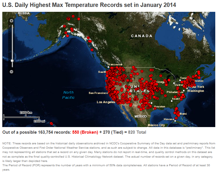
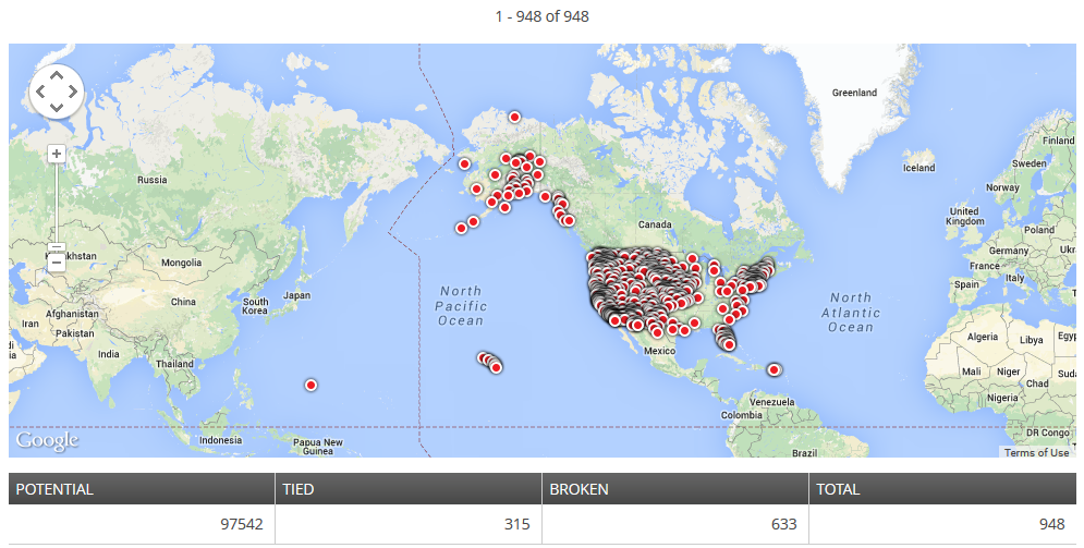
- There were more than two and a half as many record cold daily highs (2620) and lows (2174, or a total of 4794) as record warm daily highs (820) and lows (948, or a total of 1768).
- The average January national precipitation total was 1.32 inches, 0.90 inch below the 20th century average, ranking as the fifth-driest January on record and the driest since 2003. Dry conditions dominated much of the western and southern United States, with severe-to-exceptional drought engulfing much of California and Nevada. Numerous winter storms impacted the central and eastern U.S., bringing above-average snowfall but closer-to-average total precipitation for the month.
- Drier-than-average conditions were present through much of the West and Great Plains, and into parts of the Southeast and Mid-Atlantic. Eight states had January precipitation totals that ranked among the 10 driest. New Mexico had its driest January on record with 0.03 inch of precipitation, 0.57 inch below the 20th century average.
- The Alaska statewide average temperature was 14.8°F above the 1971-2000 average, marking the third-warmest January in the 96-year period of record. This was the warmest January for the state since 1985. Alaska also was wetter than average during January with a statewide precipitation total 69.8 percent above the 1971-2000 average. This was the eighth-wettest January on record for Alaska and the wettest since 1993.
- According to analysis by the Rutgers Global Snow Lab using NOAA data, the January snow cover extent across the contiguous U.S. was the 16th smallest in the 48-year period of record at 1.28 million square miles, about 82,000 square miles below the 1981-2010 average. Above-average snow cover was observed across the Northern Plains, Midwest, and Northeast where numerous winter storms brought heavy snowfall during the month, while below-average snow cover was observed for most of the West and Southern Rockies.
- According to the February 4 U.S. Drought Monitor report, 37.4 percent of the contiguous U.S. was in drought, up from 31.0 percent at the beginning of January. Drought conditions improved in the Northeast but worsened across the western Gulf Coast, the Southern Rockies, and much of the West. For the first time in the 15-year period of record for the U.S. Drought Monitor, California experienced the worst classification of drought, known as D4 or "exceptional".
- Climate Highlights — winter-to-date (December 2013–January 2014)
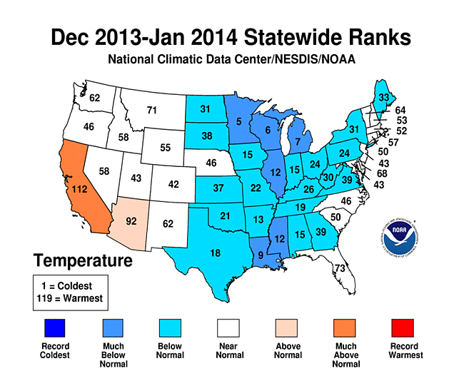
- For the first two months of the winter season, the contiguous U.S. average temperature was 30.6°F, 1.1°F below the 20th century average, and the 33rd coldest December-January on record. This was the coldest December-January since 2010/11.
- Below-average temperatures were present for much of the contiguous U.S. east of the Rockies. Louisiana, Michigan, Minnesota, and Wisconsin each had a two-month average temperature that ranked among the 10 coldest. Temperatures in the West were near to above average, where California had its eighth warmest two-month period. No state was record warm or record cold.
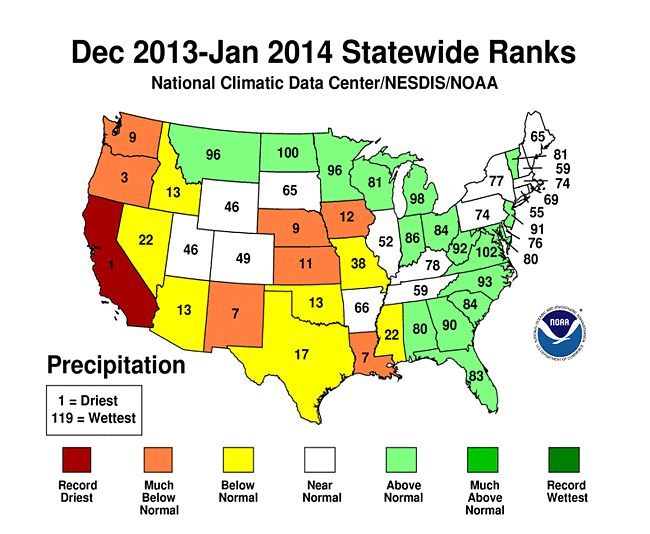
- The December-January precipitation total of 3.48 inches for the Lower-48 was 0.97 inch below average and the 11th driest December-January on record and the driest since 2000/01. Above-average precipitation was observed across the Northern Plains, Midwest, and along most of the East Coast. Below-average precipitation was observed across the West, the Central and Southern Plains, and the western Gulf Coast. Six states had two-month precipitation totals ranking among the 10 driest.
- California had its driest December-January on record with 0.94 inch of precipitation, 7.35 inches below average. The previous record dry December-January occurred in 1975/76, when the two-month precipitation total was 1.32 inches. The December-February period is typically the wettest three months for California and is an important time for the state's water resources. Winter precipitation is vital to replenish reservoirs and builds mountain snowpack that melts during the spring and summer. As of February 1, most mountain locations in California had less than 50 percent of normal snowpack and reservoirs across northern and central regions of the state had storage levels between 37 percent and 75 percent of historical averages for the date.
**A comparison of the national temperature departure from average as calculated by NCDC's operational dataset (USHCN) and the U.S. Climate Reference Network (USCRN) is available on our National Temperature Index page.**
Alaska Temperature and Precipitation:
- Temperature
- Alaska had its 3rd warmest January since records began in 1918, with a temperature 14.76°F (8.20°C) above the 1971-2000 average.
- Alaska had its 4th warmest November-January since records began in 1918, with a temperature 6.70°F (3.72°C) above the 1971-2000 average.
- Precipitation
- Alaska had its 12th wettest January since records began in 1918, with an anomaly that was 57.69% above the 1971-2000 average.
- Alaska had its 3rd wettest November-January since records began in 1918, with an anomaly that was 48.88% above the 1971-2000 average.
For additional details about recent temperatures and precipitation across the U.S., see the Regional Highlights section below and visit the Climate Summary page. For information on local temperature and precipitation records during the month, please visit NCDC's Records page.
Regional Highlights:
These regional summaries were provided by the six Regional Climate Centers and reflect conditions in their respective regions. These six regions differ spatially from the nine climatic regions of the National Climatic Data Center.
- Northeast Region: (Information provided by the Northeast Regional Climate Center)
- This January was a chilly one in the Northeast. With an average temperature of 19.5 degrees F (-6.9 degrees C), it was 4.1 degrees F (2.3 degrees C) cooler than normal. Maine was the lone warm state with a departure of +0.4 degrees F (+0.2 degrees C). In terms of departure from normal, West Virginia was the coolest state at -6.9 degrees F (-3.8 degrees C), making it their 7th coolest January on record. Departures for the remaining states ranged from -6.3 degrees F (-3.5 degrees C) in Pennsylvania to -1.3 degrees F (-0.7 degrees C) in New Hampshire. Maryland saw its 12th coolest January on record, while Pennsylvania had its 13th coolest and New Jersey had its 19th coolest. Binghamton, New York, set a record for the greatest number of January days below zero. The temperature dropped below zero 10 days this January, beating the old record of nine days set in January 1994 and January 1968. The 10 below-zero days tied February 1979 for the greatest number of days below zero in any month.
- The Northeast returned to drier-than-normal conditions in January. The region received 2.76 inches (70.10 mm) of precipitation, 89 percent of normal. Nine of the twelve states were drier than normal, with departures ranging from 74 percent of normal in Maryland and West Virginia to 96 percent of normal in New York. New Hampshire finished the month at 102 percent of normal, while Vermont and Maine received 111 percent of normal.
- According to the U.S. Drought Monitor released on January 2, 23 percent of the Northeast was abnormally dry while 7 percent was under moderate drought conditions. Precipitation throughout the month eased dryness and by month's end, 11 percent of the Northeast was abnormally dry and the areas of moderate drought had been removed.
- From January 2-3, a Noreaster dropped up to 24 inches (61 cm) of snow on parts of the Northeast. The storm packed high winds, which led to blizzard conditions and coastal flooding in southeastern Massachusetts. Kennedy Airport in New York was shutdown for several hours due to zero visibility and high winds, while sections the New York State Thruway, Long Island Expressway, and Interstate 84 were closed, as well. With a 49-degree F (27-degree C) difference between the daily high and low on the 6th, Binghamton, New York, had its largest diurnal temperature range on record. On the 7th, 23 of the Northeast's 35 first-order climate sites set records for coldest high temperature and 19 sites set record low temperatures. The cold temperatures combined with gusty winds to create wind chills as low as -50 degrees F (-46 degrees C). On the 7th, New York's power grid set a new winter peak demand of 25,738 megawatts (compared to the old record of 25,241 megawatts set on December 20, 2004). On the same day, Con Edison also set new winter peaks for electric service and natural gas use. From the 6th through the 8th, the Buffalo, New York, area experienced its first blizzard since the Blizzard of 1993 pummeled the east coast. Up to 24 inches (61 cm) of lake-effect snow fell, while winds gusted up to 50 mph (22 m/s). The New York State Thruway was closed from the Pennsylvania border north to Buffalo and east to Rochester. In Jefferson and Lewis Counties, east of Lake Ontario, snow totals of up to 60 inches (152 cm) were reported. Interstate 81 was closed from north of Syracuse to the Canadian border on the 6th and reopened on the 9th. Up to 16 inches (41 cm) of snow caused travel problems in eastern parts of the region from the 21st to the 22nd.
- For more information, please go to the Northeast Regional Climate Center Home Page.
- Midwest Region: (Information provided by the Midwest Regional Climate Center)
- Temperatures were well below normal across the Midwest in January. Despite a warm second week, average conditions for the month ranged from 5 to 10 degrees F (3 to 6 C) below normal due to very cold conditions in the first week and again in the last two weeks of the month. After two straight warm winters, the temperatures reached in January were the coldest seen in years at most locations. The most below normal areas were near the Great Lakes while areas to the west were closer to normal but still cold. Average temperatures for the month were below freezing across the nine-state region. Minimum temperatures in January averaged 0 degrees F (-18 C) or colder across Minnesota and Wisconsin and in parts of Iowa, Illinois, and Michigan.
- January precipitation was below normal for most of the Midwest, especially in the south and west with some above normal readings around the Great Lakes. Totals were less than 50 percent of normal in parts of Missouri and Iowa with western Iowa totals less than 25 percent of normal. Despite the lower precipitation totals, snowfall totals were above normal for much of the region. Snow totals exceeded two, or even three, times normal from southern Missouri eastward into Kentucky, Ohio, and Michigan. Below normal snow totals were located in the boot heel of Missouri, western Kentucky, and much of Iowa. Michigan had numerous stations report over three to five feet (91 to 152 cm) of snow downwind of Lake Superior and Lake Michigan. The snowiest location was Maple City in Leelanau County with a monthly total just short of eight feet, 95.8 inches (243 cm), which was more than double its normal amount for January.
- Several snow storms tracked across the Midwest in January. The snow, wind, and cold temperatures lead to several deaths in the region. Fatalities were reported from traffic accidents, cold exposure, and shoveling related heart attacks. Weather related deaths were reported in seven states. In week one, blizzard conditions and multi-vehicle traffic accidents closed interstate highways and even led some counties to close all roads to all but emergency vehicles. On the 23rd, I-94 in northwest Indiana had a fatal accident involving dozens of vehicles and multiple fatalities during blizzard conditions. The eastbound lanes remained closed well into the 24th as wreckers and cranes were brought in to clear the roadway.
- The persistent cold caused rivers in northern Ohio to freeze leading to ice damming. The ice dams caused ice to pile up in the rivers and in some cases spill over the banks.
- Cold temperatures and a lack of the normal snow cover in western Iowa had contributed to soils freezing to more than two feet (61 cm) under sod and down to as much as four and a half feet (135 cm) under roadways. More than 100 water mains in Des Moines have burst in January, already about a third of the city's normal annual total.
- The very cold temperatures in January, both low temperatures and long stretches at such cold temperatures, may affect many types of fruits. Damage is most likely to grape and blackberry plants. Other fruits could also be affected as temperatures were near damage thresholds but damage is less certain in hardier fruits such as apple, pear, peach, cherry, and blueberry.
- The cold temperatures may also have an effect on the Emerald Ash Borer, an invasive pest that has been spreading across the country. Although the cold will not kill off the pest population, it could keep the expansion and population growth in check allowing some trees an opportunity to recover from past damage.
- For details on the weather and climate events of the Midwest, see the weekly summaries in the Midwest Climate Watch page.
- Southeast Region: (Information provided by the Southeast Regional Climate Center)
- January was an exceptionally cold month across much of the Southeast region. The greatest departures were found across Alabama, central and northern sections of Georgia, and western sections of the Carolinas and Virginia, where monthly temperatures were 6 to 8 degrees F (3.3 to 4.4 degrees C) below average. Monthly temperatures were 3 to 5 degrees F (1.6 to 2.8 degrees C) below average across central and eastern sections of Virginia and the Carolinas, southern Georgia, and the Florida Panhandle, while much of the Florida Peninsula was near average to slightly below average for the month. Over 50 locations in the Southeast experienced one of their top 3 coldest Januarys on record, including Montgomery, AL and Macon, GA. In contrast, monthly temperatures were above average across Puerto Rico and the U.S. Virgin Islands. San Juan, PR (1898-2013) experienced its warmest January on record with a monthly temperature of 80.2 degrees F (26.8 degrees C), breaking the old record of 79.8 degrees F (26.6 degrees C) set back in 1981. Three significant cold outbreaks affected the Southeast region in January. A bitterly cold air mass overspread much of the region on the 7th and 8th of the month, resulting in subfreezing temperatures as far south as central Florida. For several locations, including Raleigh-Durham, NC and Atlanta, GA, this event marked the strongest cold outbreak not associated with snow cover in nearly 20 years. Maximum temperatures failed to climb above freezing across southern Georgia and Alabama, while windy conditions resulted in wind chill values below 0 degrees F (-17.8 degrees C) as far south as Birmingham, AL. Over 350 daily minimum temperature records and over 200 daily low maximum temperature records were tied or broken across the region over this two-day period. Mount Mitchell, NC recorded a minimum temperature of -24 degrees F (-31.1 degrees C) on the morning of the 7th. This marked the second coldest temperature ever recorded at the summit (since 1980) and tied for the 8th coldest temperature on record in North Carolina. The unusually cold temperatures forced several school districts across the Southeast to delay or cancel classes. A second cold outbreak occurred from the 22nd to the 25th of the month, with temperatures across the northern half of the region running between 20 and 25 degrees F (10 and 13 degrees C) below average. The final cold outbreak occurred near the end of the month in the days following a major winter storm. Over 80 daily minimum temperature records and over 250 daily low maximum temperature records were tied or broken on the 29th and 30th of the month.
- Precipitation in January was below average across much of the Southeast region, except across the Florida Peninsula where precipitation was generally above average for the month. The greatest deficits were found across Alabama, where monthly precipitation totals were as much as 3 to 5 inches (76.2 to 127.0 mm) below average. Precipitation was also below average across Puerto Rico and the U.S. Virgin Islands, where monthly deficits of 1 to 4 inches (25.4 to 101.6 mm) were observed. Monthly totals were 1 to 2 inches (25.4 to 50.8 mm) below average across much of Georgia and the Carolinas, except along a swath stretching across central South Carolina and south-central North Carolina where strong thunderstorms dropped between 2 and 4 inches (50.8 and 101.6 mm) of rain on the 11th of the month. The wettest locations across the Southeast in January were found in Palm Beach County, FL, where an incredible 22.21 inches (564.1 mm) of rain fell in the town of Hypoluxo on the 9th and 10th of the month. Other locations in the county reported between 13 and 18 inches (330.2 and 457.2 mm) of rain from the event, most of which fell over a period of just a few hours. The resulting flood waters forced several road closures, including a stretch of I-95 near Boynton Beach.
- The Southeast was impacted by three winter storms in January. The first storm occurred on the 15th and 16th of the month and produced up to 2 inches (50.8 mm) of snow across western portions of North Carolina and Virginia and up to 1 inch (25.4 mm) of snow across central and northern portions of Virginia. Trace amounts of snow were also reported in the mountains of Georgia. The second storm occurred on the 21st and 22nd of the month and resulted in widespread snow across the northern half of the region. The heaviest amounts were found along the higher elevations of the Southern Appalachians and across northern Virginia, where 5 to 10 inches (127.0 to 254.0 mm) were reported. Snowfall rates of 1 to 3 inches (25.4 to 76.2 mm) per hour were reported in the Washington D.C. area. In addition, central and eastern regions of Virginia and North Carolina reported between 1 and 5 inches (25.4 and 127.0 mm) of snow, while snow showers were observed along the Outer Banks of North Carolina. The third storm occurred about a week later and resulted in mostly snow across the interior of the region and a mix of snow, sleet, and freezing rain that extended across coastal sections of Alabama, northern Florida, and across eastern and coastal sections of Georgia and the Carolinas. For many locations along the northern Gulf Coast and southeast Atlantic Coast, this was the first major winter storm in over a decade. In fact, some locations, such as Pensacola, FL, recorded their first measurable snowfall in over 30 years. Freezing rain accumulations were highest across southern Georgia and eastern South Carolina, where 0.5 to 1.0 inches (12.7 to 25.4 mm) were reported, while sleet accumulations of 1 to 2 inches (25.4 to 50.8 mm) were reported across southern Alabama and southeastern North Carolina. Snow totals ranged from 1 to 4 inches (25.4 to 101.6 mm) across much of the interior of the region, while eastern sections of North Carolina and Virginia reported between 5 and 10 inches (127.0 and 254.0 mm) of snow. Icy conditions resulted in several road and bridge closures, including a portion of I-10 west of Tallahassee, FL and the iconic Ravenel Bridge in Charleston, SC, where a number of cars were damaged from ice breaking off of the bridge cables. In addition, numerous school districts across the Southeast were closed for up to four days (from the 28th through the 31st). The most notable impacts from this storm occurred in the cities of Atlanta, GA and Birmingham, AL, where rapidly accumulating snowfall and the near simultaneous release of schools, business, and government offices resulted in over 1,000 accidents and created massive gridlock on highways and interstates beginning around mid-day on the 28th. Hundreds of injuries and several fatalities have been reported, though official numbers have not yet been confirmed. Some motorists in Atlanta remained stranded on the roads for over 24 hours, while others were forced to abandon their cars and take shelter in nearby stores and offices. In addition, nearly 100 school buses were stranded on Atlanta-area roads and highways, some for as many as 12 hours. In Birmingham, over 5,000 students were forced to spend the night in schools due to traffic congestion and road closures.
- There were 169 reports of severe weather across the Southeast in January. Nearly all of these reports occurred on the 11th of the month as a line of strong thunderstorms tracked across the region. High winds were reported from central Alabama and northwest Florida to southeastern Virginia, resulting in downed trees and power lines, as well as damage to numerous homes and buildings. The Raleigh-Durham, NC International Airport (KRDU) recorded a wind gust of 86 mph (75 knots) on the afternoon of the 11th, which is the second highest wind gust recorded at that station since 1948. In addition, four weak (EF-0) tornadoes were confirmed from this event. The first occurred early in the morning on the 11th in northern Cherokee County, GA, resulting in several downed trees. The remaining three tornadoes occurred later in the afternoon across parts of southeastern Virginia, two of which were reported in Isle of Wight County. The third tornado occurred near the city of Hampton and resulted in major damage to several buildings in the Fox Hill community.
- There were relatively few changes made to the Drought Monitor across the Southeast in January. The lack of rain over the past few months across the Deep South resulted in an expansion of abnormally dry (D0) conditions into northern, southern, and western sections of Alabama. Abnormally dry conditions continued to persist across extreme southeastern North Carolina and parts of South Florida where winter season precipitation deficits have been the greatest. According to the Florida State Climate Office, the cold outbreak and high winds early in the month caused some damage to winter oats and vegetable crops across the central and southern parts of the state, while the cold temperatures in the wake of the winter storm at the end of the month resulted in more widespread damage to crops across the Panhandle region.
- For more information, please go to the Southeast Regional Climate Center Home Page.
- High Plains Region: (Information provided by the High Plains Regional Climate Center)
- The High Plains region experienced quite a range in temperatures this month with a combination of both warm spring-like days and bitterly cold days. For instance, in Nebraska, where snowpack was lacking, the highest temperatures of the month were generally in the mid-60s (upper teens in degrees C) and the lowest temperatures were 10-15 degrees F below zero (-23.3 to -26.1 degrees C), resulting in over a 70 degree F (38.9 degree C) temperature range for the month. Individual days also had quite the diurnal range. On January 29th, Lincoln, Nebraska had a low temperature of -5 degrees F (-20.6 degrees C) and a high temperature of 47 degrees F (8.3 degrees C) which resulted in a 52 degree F (28.9 degree C) temperature range that day alone. In the end, most of the High Plains region averaged out to near normal with above normal temperatures generally in the west and below normal temperatures in the east. Many Arctic air masses impacted the eastern half of the U.S. this month, but for the most part these air masses slid just off to the east of the region. For instance, while the far eastern edge of the region had temperature departures of 2.0-6.0 degrees F (1.1-3.3 degrees C) below normal, much of the Midwestern region had temperature departures of 6.0-10.0 degrees F (3.3-5.6 degrees C) below normal. These cold air masses were accompanied by high winds resulting in dangerously low wind chills for areas of the Dakotas and Nebraska.
- Precipitation was sparse for most of the High Plains region this month. Large areas of Kansas, Nebraska, South Dakota, and North Dakota were dry with precipitation totals less than 50 percent of normal. Additionally, areas of southern and eastern Kansas, eastern and northern Nebraska, and southern South Dakota received less than 25 percent of normal precipitation. The ongoing dryness in Kansas and Colorado continued to have impacts. A mid-month dust storm in the Pueblo, Colorado area caused several accidents and closed I-25 for a portion of the day. A similar scene played out just a few days later in northwestern Kansas where a dust storm reduced visibilities, caused accidents, and closed I-70 for several hours. These are just two examples of dust storms that occurred in these drought-stricken areas this month. Some locations within the dry areas of the region experienced quite a 'snow drought' this month as even areas in the Deep South received more snowfall. For instance, Atlanta, Georgia with 2.6 inches (7 cm) had more snow this month than Omaha, Nebraska, with 1.8 inches (5 cm). Luckily, since winter is typically the driest part of the year, precipitation deficits have not increased drastically. A lack of snow cover can have its advantages, however, this year the multiple extreme cold events combined with a lack of snow cover may be a risk to the winter wheat crop in Kansas and Nebraska. Not all areas of the region were lacking snowfall this month. Areas receiving above normal precipitation included northern Colorado along with pockets of Wyoming and North Dakota. The highest precipitation totals occurred in northern Colorado, where totals were up to 400 percent of normal. The popular ski destination of Breckenridge, Colorado had its 3rd snowiest January on record with 49.7 inches (126 cm) of snow (period of record 1893-2014). The snowiest January in Breckenridge occurred way back in 1899 with 79.8 inches (203 cm). On average, the town receives about 23.0 inches (58 cm) of snow during the month of January. Cheyenne, Wyoming was also a snowy spot with 15.0 inches (38 cm) of snow, marking its 7th snowiest January (period of record 1883-2014). The 1980 record of 35.5 inches (90 cm) held. Other areas of the region were impacted by snowfall, especially when combined with windy conditions which were a recurring feature this month. Ground blizzards in the Dakotas were quite an issue as high winds caused blowing snow and created treacherous travel conditions. During the blizzard on January 26th for instance, both I-29 and I-94 were both closed. Across the western U.S., this season's snowpack has been a story of the haves and the have-nots. Generally, eastern areas have fared well, while many areas to the west have struggled due to higher than normal temperatures and drought conditions. For instance, snowpack in California and Oregon has been abysmal so far this season and reservoirs have been in severe decline. Luckily, places like northern Colorado and much of Wyoming have fared better, especially when compared to last year. By the end of the month, Wyoming's statewide snowpack was 113 percent of average and Colorado's statewide snowpack was 94 percent of average. In contrast, last year's snowpack was 76 percent of average and 75 percent of average, respectively.
- There were only small changes to the U.S. Drought Monitor in the High Plains region this month. Approximately 23 percent of the Region was in moderate (D1) to exceptional (D4) drought at the end of January, which was a slight increase from 21 percent at the end of December. Degradations were present in southwestern Colorado and across Kansas. In Kansas, higher than normal temperatures combined with dry and windy conditions led to an expansion of drought there. Both areas of extreme drought (D3) expanded to the west, while areas of severe (D2) and moderate (D1) drought expanded to the east. Abnormally dry conditions (D0) also expanded eastward. By the end of the month, 63 percent of the state was in drought, which was quite a difference from last month's 47 percent. As expected this time of the year, little change is predicted over the next few months. According to the U.S. Seasonal Drought Outlook released January 16th, current drought conditions are expected to persist across Nebraska, Kansas, Colorado, and Wyoming through April 2014. Drought development is still expected in southwestern Colorado.
- For more information, please go to the High Plains Regional Climate Center Home Page.
- Southern Region: (Information provided by the Southern Regional Climate Center)
- The month of January was a very cold month for the entire Southern Region. Temperatures dipped down into the teens even as far south as Baton Rouge, Louisiana. The deep south experienced several hard freezes and two winter storms, which will make this past January a month to remember. Temperature anomalies for the month varied spatially from west to east. Texas and Oklahoma averaged between 2 to 4 degrees F (1.11 to 2.22 degrees C) below normal, while the central portions of the region, including Arkansas and northern Louisiana, averaged between 4 to 6 degrees F (2.22 to 3.33 degrees C) below normal. Farther east and in southern Louisiana, temperatures were even colder than normal, with most stations averaging from 6 to 10 degrees F (3.33 to 5.56 degrees C) below normal. All six states experienced a colder than normal month. The statewide average temperatures are as follows: Arkansas reported 34.90 degrees F (1.61 degrees C), Louisiana reported 43.30 degrees F (6.28 degrees C), Mississippi reported 38.00 degrees F (3.33 degrees C), Oklahoma reported 35.90 degrees F (2.17 degrees C), Tennessee reported 30.00 (-1.11 degrees C), and Texas reported 44.30 degrees F (6.83 degrees C). For Tennessee and Mississippi, it was the seventh coldest January on record (1895-2014), while Louisiana recorded its eighth coldest January on record (1895-2014). Arkansas reported its fourteenth coldest January on record (1895-2014), while for Texas it was their thirtieth coldest January (1895-2014). Oklahoma experienced their forty-fifth coldest January on record (1895-2014).
- In addition to being anomalously cold, January was a very dry month for the Southern Region. Most of the region saw precipitation totals that were less than half of normal. In Arkansas and Tennessee, precipitation totals varied between 50 to 70 percent of expected values. Throughout most of Louisiana and Mississippi, precipitation totals ranged between one fourth and half of normal for the month. Conditions were even drier in Texas and Oklahoma. Much of the western half of Texas experienced an extremely dry month, with precipitation totals ranging from zero to five percent of normal. Many stations, in that area, reported no precipitation at all. The statewide average precipitation totals for the month are as follows: Arkansas reported 2.04 inches (51.81 mm), Louisiana reported 2.15 inches (54.61 mm), Mississippi reported 2.04 inches (51.82 mm), Oklahoma reported 0.30 inches (7.62 mm), Tennessee reported 2.68 inches (68.07 mm), and Texas reported 0.39 inches (9.91 mm). For the state of Texas, it was the fifth driest January on record (1895-2014), while Mississippi and Oklahoma reported their seventh and eighth driest January on record (1895-2014), respectively. Louisiana experienced their twelfth driest January on record (1895-2014), and Tennessee saw its eighteenth driest on record (1895-2014). For Arkansas, it was the twenty-first driest January on record (1895-2014).
- Drought conditions over the month of January remained relatively unchanged, despite it being a very dry month across the region. In Louisiana, a small area of moderate drought has been added in the south central portions of the state. There was also some moderate drought added along the Texas Gulf coast region.
- The primary weather story for the month of January in the Southern Region is not only how cold it was, but there were two separate winter storms, that caused numerous delays at airports and school closures. In southern Louisiana, most schools were closed on January 24th and 25th, including Louisiana State University. Snow and ice accumulations in the southern parts of the region ranged from less than a quarter inch to over two inches. To provide some perspective of just how cold the month of January was, Baton Rouge, Louisiana experienced eleven hard freeze nights (where the temperature dipped below 28 degrees F (-2.22 degrees C)). Based on the period of record at Baton Rouge Ryan Airport, approximately ten percent of days in January experience temperatures below 28 degrees F (-2.22 degrees C). For January, 2014, it was thirty-five percent of the days or three and a half times the long-term average (1930-2014).
- In Texas, many lakes across the state are at dangerous levels, including the Highland Lakes, which are at a combined 38% capacity. This is raising concerns that water prices across the Lower Colorado River Authority region could increase by 20% next year. The low water supply levels became evident when the State Comptroller's Office released a statement on January 17 reporting that 23,000 Texans are at risk to losing water service within 45 days and another 47,000 running that risk at 90 days. The USDA placed 180 counties within the state under a Natural Disaster Declaration, giving farmers and ranchers the option to apply for low interest rate federal loans to make up for losses. The Panhandle from 2010-2013 has surpassed the 1954-1956 time period as the record driest three year period on record. Wichita Falls, still under Stage 4 water restrictions, is considering a cloud seeding project that could cost more than $50,000 per month (Information provided by the Texas Office of State Climatology).
- In Texas, two winter weather events took place this month, hitting the southern part of the state with a mixture of icy precipitation. A mixture of freezing rain, sleet, and snow began falling from Waco south towards Houston late on the 23rd, causing 150 flight cancellations at Bush Intercontinental and Houston Hobby airports and more than 250 wrecks in Austin. The second event occurred on the 28th bringing light freezing rain to Houston and a few flurries to the north, bring less ice accumulation but still more cold temperatures. The cold temperatures that came along with the ice storms are having their own share of problems. In the Panhandle, the cold combined with the lack of short-term rain has many winter wheat growers fearful that a large-scale crop die-off is imminent. Power consumption across the state is increasing rapidly, with a record of 57,277 megawatts of power were used across the state on the sixth and Upshur Electric purchasing more than 10,000 more KW hours than last year (Information provided by the Texas Office of State Climatology).
- For more information, please go to the Southern Regional Climate Center Home Page.
- Western Region: (Information provided by the Western Region Climate Center)
- A strong and persistent ridge over the West Coast kept coastal states much warmer and drier than normal this month, exacerbating drought conditions that have developed over the past 30 months. The position of the ridge allowed storms to move through the northern and central Rocky Mountains, bringing above normal precipitation there.
- Above normal temperatures dominated the West this month following a cooler than normal December. Many stations in California broke long-standing temperature records. On January 24th, the mercury rose to 79 F (26.1 C) in Sacramento, California, setting a new record for the highest January temperature. The previous record was 74 F (23.3 C) on January 31, 1976. The average temperature in Sacramento was 52.7 F (11.5 C), the second highest January average in the station's 137-year record. South of there, the second warmest January in Bakersfield since records began in 1937 ended up at 54.2 F (12.3 C), with a record 12 days over 70 F (21.1 C). San Francisco downtown averaged 56.5 F (13.6 C), the 2nd warmest January in its 166-year record. Further south, Santa Maria saw its warmest January in a 67-year record at 58.6 F (14.8 C), 7.1 F above normal. This includes their all-time January high of 89 F (31.7 C), recorded on the 16th. In Nevada, Las Vegas recorded its 2nd highest average January temperature at 53.1 F (11.7 C). The temperature did not drop below freezing this month in Las Vegas, the 5th such January since records began in 1937t been observed. Elsewhere in the Southwest, Phoenix, Arizona recorded an average 59.9 F (15.5 C) for the month, the second warmest January in a 120-year record. Many locations in the Northwest had record January warmth as well. Omak, in central Washington, logged its warmest January in a 105-year record at an average 50 F (10 C), including an all-time January high of 61 F (16.1 C) on the 17th. In central Idaho, temperatures at Ketchum averaged to 25.9 F (-3.4 C) for January, the second warmest since records began in 1938.
- Below normal precipitation accompanied this month's above normal temperatures, expanding drought conditions in many western states and prompting a drought State of Emergency declaration by the Governor of California. At the beginning of the month 27.5% of California was categorized as D3 or D4 (extreme to exceptional drought) by the US Drought Monitor. By the end of January, this figure rose to 67%. In southern California, Los Angeles received no measurable January precipitation. Since records began in 1878, this has only occurred in four other years. Sacramento set a record for the longest spell of consecutive stretch with no rain at 52 days, from December 7-January 29. With a total of 0.22 in (5 mm), this January was the 3rd driest since Sacramento's records began in 1877. San Francisco saw only 0.06 in (2 mm) of rain this for the driest January in the past 166 years. Normal January precipitation in San Francisco is 4.5 in (114 mm). Drought conditions also worsened in northern Nevada, Oregon, Washington, Idaho, Arizona and New Mexico this month. In Arizona, Flagstaff had a run of 39 days (December 22-January 29) without precipitation, the longest winter dry streak in the station's 87 years of data. Albuquerque, New Mexico, also received no measurable January precipitation for the 9th time since 1897. In the Northwest, Medford, Oregon, recorded 0.78 in (20 mm) for the month, the 7th driest in a 103-year record. Yakima, Washington saw only 0.3 in (8 mm) precipitation this month, the 9th driest January in a 68-year record.
- At month's end, snowpack was very low in the northern Great Basin and coastal states. These regions saw snow water equivalent (SWE) values <75% of normal with a low of 15% of normal in the Lake Tahoe Basin of the Sierra Nevada. SWE values increased to the east, with basins in Utah and Idaho measured SWE values 50-100% of normal. Further east, most basins in western Montana, Wyoming, and Colorado had SWE values over 100% of normal. In Colorado, 14.3 in (36 cm) of snow fell in Denver for the 11th snowiest January on record. Cheyenne, Wyoming logged its 6th wettest January in a 100-year record with 1.01 in (26 mm) precipitation. Billings, Montana saw its 11th snowiest January in the past 80 years, with 18.2 in (46 cm) of snowfall this month. This winter is the 5th snowiest at Billings thus far at 55.8 in (142 cm).
- Above normal temperatures and precipitation were observed throughout Alaska this month. In the South Central region of the state, Gulkana recorded 1.79 in (45 mm) precipitation for the month for its wettest January in the past 72 years. It was also the 2nd warmest January at Gulkana, where temperatures averaged to 18.5 F (-7.5 C), 21.4 F (12 C) above normal. In the central part of the state, McGrath also recorded its 2nd warmest January average at 13.5 F (-10.3 C), 20 F (11 C) above normal.
- January (all month): Out-of-season fires in California: Dry conditions permitted several fires to char California this month. In southern California, the Colby Fire, destroyed five residences and 10 buildings and burned 1952 acres (790 hectares). The Mission Fire in Jurupa Valley, fanned by Santa Ana winds, demolished four homes. Further north, the Soda Fire burned 1274 acres (516 hectares) in Sequoia National Forest. In northern California, the Campbell Fire charred 865 acres (350 hectares) in Lassen National Forest.
- January (late month): Avalanches near Valdez, Alaska: Unseasonably warm temperatures and rain-on-snow events caused several large avalanches in South Central Alaska. The Lowe River was blocked by an avalanche 30 ft (9 m) deep and 200 yards (183 m) wide. Water backing up behind the avalanche has the potential to cause flash flooding. The Richardson Highway was also closed, cutting off land access to Valdez.
- For more information, please go to the Western Regional Climate Center Home Page.