

| In Sudan, heavy rains
during August 1-3 produced flooding that was blamed for at least 20
deaths across the country (Reuters). Flooding along the Gash river
near Kassala, which is located about 450 km (280 miles) east of the
capital city of Khartoum, was described as the worst in 70
years. |

larger
image
|
At least one million people were affected by seasonal monsoon
rains in southern Pakistan. Heavy rains, which began in July,
caused 162 deaths in Pakistan as of August 3, with 153 of the
fatalities in the Sindh province (AFP). More than half a million
houses had been damaged or washed away in an area more than 1,000
square kilometers (400 square miles) in size. In Nepal, floods from
monsoon rains had claimed 205 lives and destroyed over 3,000 houses
(OCHA).
In the United States, thunderstorms on the 19th brought some of
the heaviest rainfall and flooding to the Las Vegas, Nevada area
since 1999. As much as 75 mm (3 inches) of rain fell in parts of
the area in just 30 minutes, producing widespread flooding and
prompting the mayor to declare a state of emergency (Las Vegas
Sun).
In China, at least 86 people were killed and $700 million
reported in losses (Reuters) due to flooding, landslides and
Typhoon Dujuan in August and early
September. Twelve days of heavy rain in the northern province of
Shaanxi led to some of the worst flooding in 40 years for the
region. Approximately 4.9 million people were affected by the
flooding (Reuters). Details of Typhoon
Dujuan can be be found below.
For an archive of flood events worldwide, see the
Dartmouth Flood Observatory.

| A cold frontal passage
signaled the end of the heat wave for much of Europe, although
strong thunderstorms associated with the front brought severe
weather to parts of southern France and Spain. The storms produced
flooding and scattered power outages as they affected the region on
the 17th. |

Click for
Animation (4.7MB)
|
 larger
image
larger
image
|
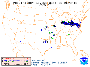
In the United States,
a
derecho associated with a cluster of severe thunderstorms
affected parts of the Ohio Valley eastward through sections of the
Mid-Atlantic. There were numerous reports of wind damage as the
storms rolled through the region on the 26th. |

 larger
image
larger
image
|
Typhoon Morakot:
developed in the western Pacific Ocean on the 1st and reached
typhoon strength by the 3rd. Morakot then tracked westward across
southern Taiwan on the 4th with maximum sustained winds of 120
km/hr (65 knots or 75 mph). Morakot made landfall and weakened
across southeastern China's Fujian province by the 5th. |
| Typhoon Etau: developed in
the western Pacific Ocean on the 3rd and attained typhoon status by
the 4th. Etau crossed Japan during the 8-10th, with maximum
sustained winds near 165 km/hr (90 knots or 105 mph) as it skirted
Shikoku on the 8th. More than 400 mm (16 inches) of rain fell on
parts of Hokkaido, flooding more than 1,000 homes. Etau was
responsible for 8 deaths in Japan (Associated Press). |

larger
image
|
 larger
image
larger
image
|
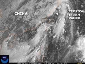
Tropical Storm
Vamco:
developed in the Philippine Sea on the 19th and crossed into
southeast China's Fujian and Zhejiang provinces on the 20th.
Maximum sustained winds at the time of landfall were near 65 km/hr
(35 knots or 40 mph), and the storm produced heavy rainfall and
localized flooding across the northern Philippines and southeastern
China. |
| Typhoon Krovanh: formed
on the 15th in the open waters of the western Pacific Ocean and
achieved typhoon status
by the 21st. Krovanh made landfall along the coast of Vietnam
near the border with China on the 25th. The storm was the strongest
typhoon to strike Vietnam in more than a decade, killing one person
and destroying nearly 1,000 homes (Disasterrelief.org). In
neighboring China, more than 11,000 homes were destroyed in
Guangdong and Hainan provinces. It was the twelfth typhoon to
affect China in 2003. |

larger
image
|
 larger
image
larger
image
|
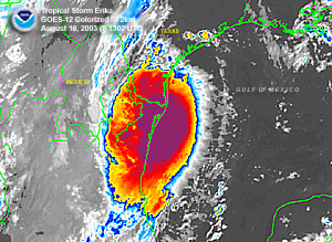
Tropical Storm
Erika
developed in the eastern Gulf of Mexico on the 14th and crossed
into northern Mexico about 70 km (45 miles) southeast of
Brownsville, TX in the United States on the 16th. Maximum sustained
winds at the time of landfall were near 110 km/hr (60 knots or 70
mph). No significant damage or flooding was reported in south
Texas, although trees were downed and roof damage occurred along
the coast of northern Mexico (Associated Press). |
| Hurricane Ignacio:
developed off the west coast of Mexico on the 21st and became a
hurricane by the 24th as it entered the Gulf of California. Ignacio
made landfall along Mexico's Baja Peninsula on the 26th, bringing
very heavy rainfall and maximum sustained winds near 120 km/hr (65
knots or 75 mph). The storm battered the city of La Paz for more
than 48 hours with strong winds and flooding rains. The La Paz
airport and area schools were closed, and around 10,000 people
evacuated to emergency shelters. By the 27th, Ignacio had weakened
into a tropical depression as it tracked over the central Baja
Peninsula. |

larger
image
|
| A strong category 4
typhoon at is peak, the eye of Typhoon Dujuan passed
close to the southern tip of Taiwan with peak winds at 230 km/hr
(125 knots or 145 mph). Two fatalities in Taiwan were attributed to
the powerful storm before it began weakening as it approached the
coast of China. Dujuan swept ashore in the Guangdong province of
China on the 2nd and 3rd of September killing at least 38 people
(Reuters). According to the Xinhua News Agency, about 1,000 people
were injured in southern China as a result of the Typhoon. |

larger
image
|

larger
image
|
Hurricane Fabian
developed in the eastern Atlantic from a tropical wave on the 27th
of August, several hundred miles west of the Cape Verde Islands.
Fabian became a tropical storm on the 28th and a hurricane on the
29th, and reached 'major hurricane' status (category 3 or higher on
the Saffir-Simpson
scale) on the 30th. Fabian reached category 4 strength on the
31st, but did not reach maximum windspeeds of 230km/hr (125 knots
or 145 mph) until September 1st. The September hazards
page contains more details of Hurricane Fabian and its impact
on the island of Bermuda. |
| Tropical Storm
Grace
developed in the Gulf of Mexico on the 30th and moved ashore near
Port O'Connor, Texas on the 31st with maximum sustained winds near
65 km/hr (35 knots or 40 mph). Heavy rainfall was the primary
impact of Grace, with 50-130 mm (2-5
inches) common along parts of the Texas Gulf Coast. |

larger
image
|
| A powerful storm
system in the South Atlantic Ocean swept a cold front into South
Africa during August 18-20. Heavy rains, mountain snows and strong
winds affected southwestern Cape Province with winds of 90 km/hr
with gusts to 130 km/hr (55 mph with gusts to 80 mph). This caused
considerable wind damage to parts of the greater Cape Town area
(South African Weather Service). |

Click For
Animation
|

References:
Basist, A., N.C. Grody, T.C. Peterson and C.N. Williams, 1998:
Using the Special Sensor Microwave/Imager to Monitor Land Surface
Temperatures, Wetness, and Snow Cover. Journal of Applied
Meteorology, 37, 888-911.
Peterson, Thomas C. and Russell S. Vose, 1997: An overview of
the Global Historical Climatology Network temperature data base.
Bulletin of the American Meteorological Society,
78, 2837-2849. |


