U.S. Drought Highlights:

- On the national scale, severe to extreme drought affected about 23 percent of the contiguous United States as of the end of August 2003
- moderate to extreme drought affected about 36 percent of the contiguous U.S.
- Short-term conditions were dry across much of the central and northern Great Plains to western Great Lakes, parts of the West, and a few locations in the southern Plains and along the east coast
- Very heavy rain fell at the end of an otherwise very dry month across much of Oklahoma, Kansas, and Missouri
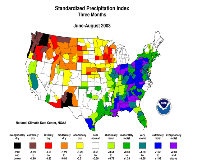
- Generally dry conditions prevailed during the summer (June-August) across much of the Pacific Northwest to western Great Lakes and parts of the Southwest
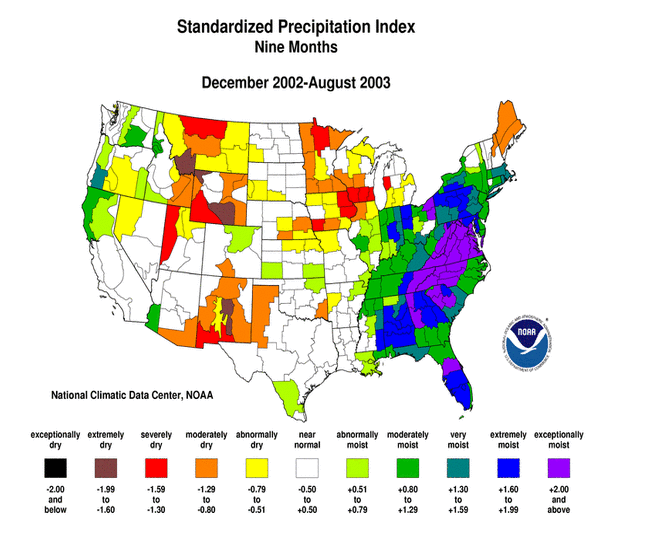
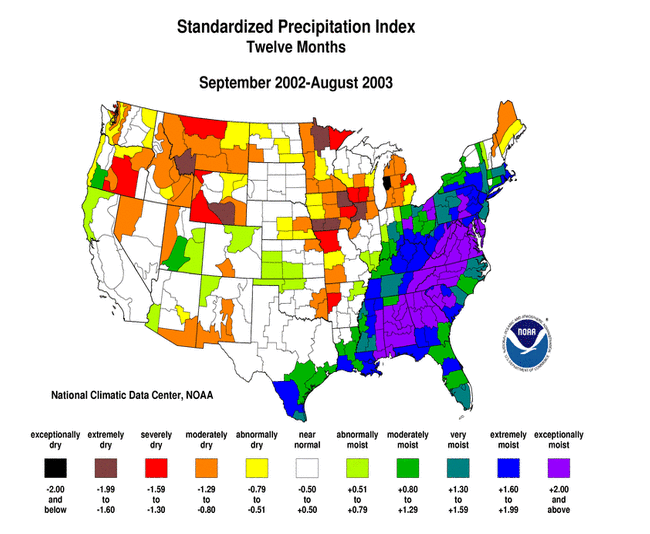
- Long-term moisture deficits persisted across parts of the central and northern Plains, Maine, and much of the West
Please Note: The data presented in this drought report are preliminary. Ranks, anomalies, and percent areas may change as more complete data are received and processed.
National Overview
On the national scale,
- severe to extreme drought affected about 23 percent of the contiguous United States as of the end of August 2003, an increase of about 3 percent compared to last month
- about 36 percent of the contiguous U.S. fell in the moderate to extreme drought categories (based on the Palmer Drought Index) at the end of August
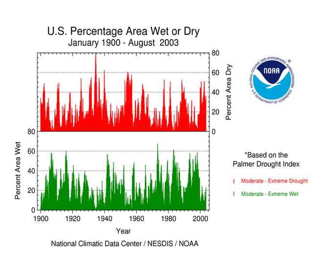
- on a broad scale, the last two decades were characterized by unusual wetness with short periods of extensive droughts, whereas the 1930s and 1950s were characterized by prolonged periods of extensive droughts with little wetness (see graph below right)
- about 15 percent of the contiguous U.S. fell in the severely to extremely wet categories at the end of August
- a file containing the national monthly percent area severely dry and wet from 1900 to present is available
- historical temperature, precipitation, and Palmer drought data from 1895 to present for climate divisions, states, and regions in the contiguous U.S. are available at the Climate Division: Temperature-Precipitation-Drought Data page in files having names that start with "drd964x" and ending with "txt" (without the quotes).
Regional Overview
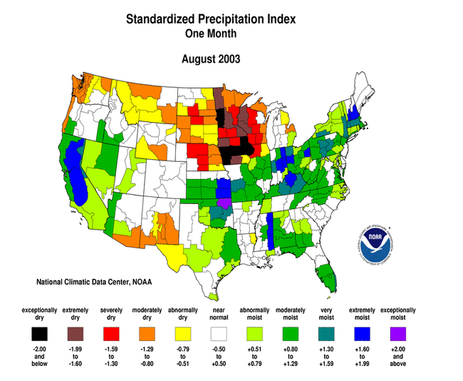
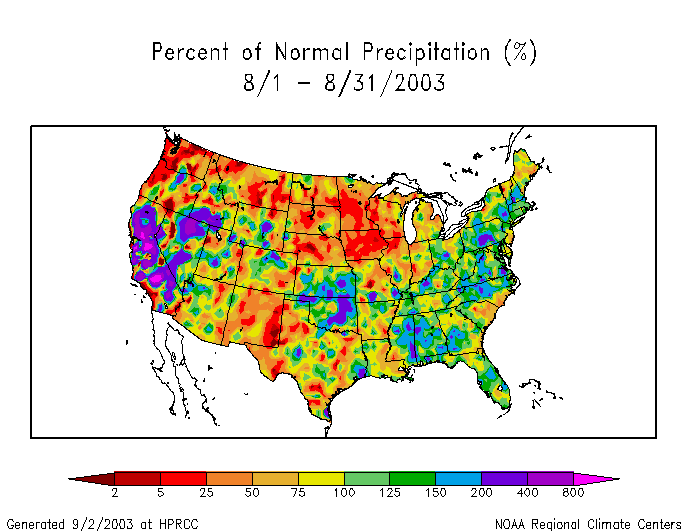
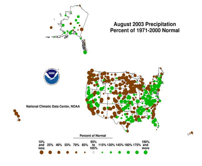
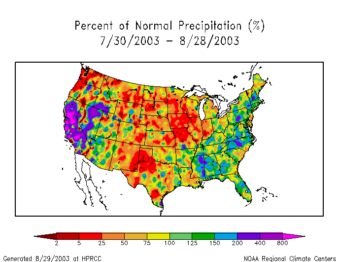
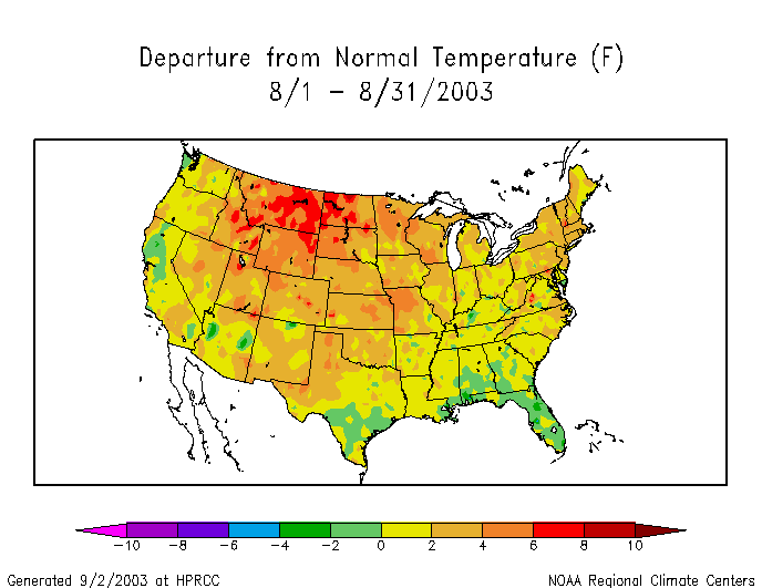
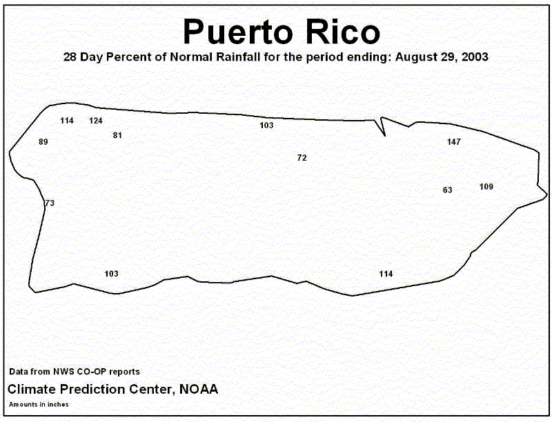
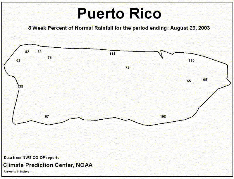
August was hot and dry in the northern Plains and Upper Mississippi Valley, resulting in extreme short-term drought from the western Great Lakes to the northern Rockies. The month was also dry across parts of the West and a few locations in the southern Plains and along the east coast. Very heavy rain fell at the end of an otherwise very dry month across much of the central Plains (Oklahoma, Kansas, and Missouri). The primary stations in Hawaii were drier than normal during August. The precipitation pattern for the stations in Puerto Rico for the last 4 weeks to 8 weeks, and for the primary stations in Alaska, was mixed.

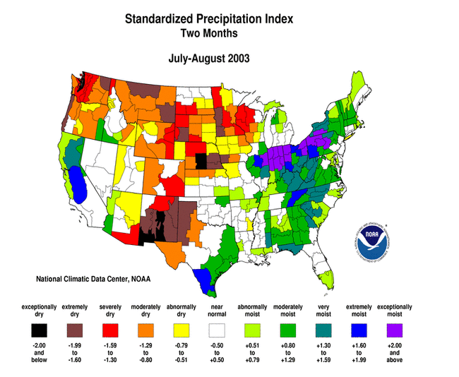
The dryness of August was a continuation of very dry conditions from July in some areas and for the entire summer in other areas. Long-term moisture deficits persisted across parts of the Great Lakes to Great Plains, northern Maine, and much of the West.
Some regional highlights:
- New Mexico had its driest July-August, Washington its driest June-August, and Iowa and Minnesota their second driest August, in 2003, based on statewide records going back to 1895
- record heat occurred at many stations in the West and Great Plains
- according to August 31 reports from the USDA,
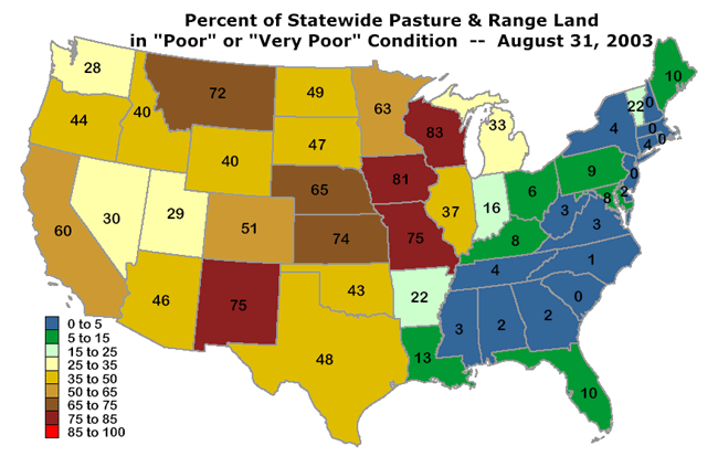
- 40% or more of the pasture and range land was classified in "poor" or "very poor" condition for all but five states west of the Mississippi River, with conditions significantly deteriorating over the last four weeks
- 65% or more of the pasture and range land was classified in "poor" or "very poor" condition for Iowa, Kansas, Missouri, Montana, Nebraska, New Mexico, and Wisconsin
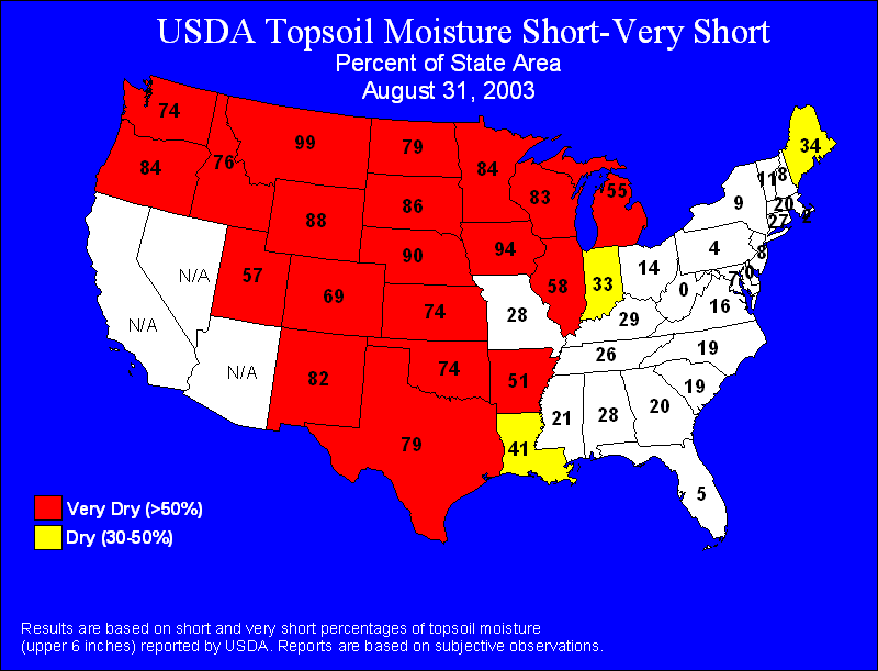
- 55% or more of the topsoils were classified in "poor" or "very poor" ("short" or "very short") condition for all but one of the reporting states from the Great Lakes to Texas then westward to the Pacific coast
- Montana, Iowa, and Nebraska had 90% or more of the topsoils in "poor" or "very poor" condition
- 40% or more of the pasture and range land was classified in "poor" or "very poor" condition for all but five states west of the Mississippi River, with conditions significantly deteriorating over the last four weeks
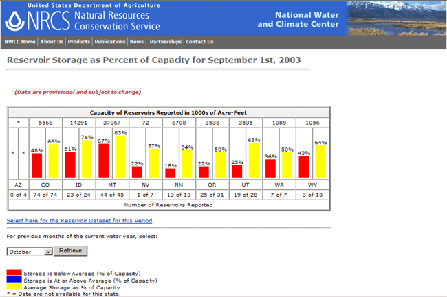
- end-of-August reservoir storage for all of the reporting western states averaged below the long-term mean percent of capacity for this time of year
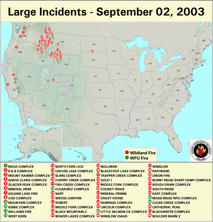
- as noted by the National Interagency Fire Center, about four dozen significant wildfires continued to burn across the northern Plains and western states at the beginning of September