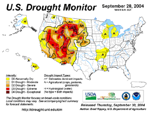
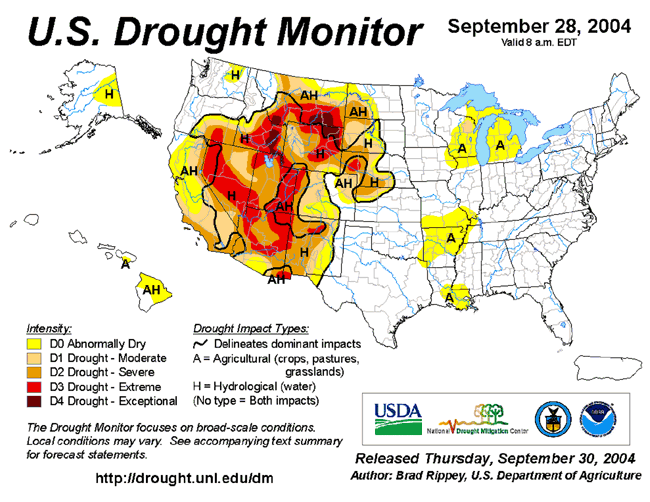
| In the United States,
severe to exceptional long-term drought continued throughout much
of the Intermountain West, with the worst-affected areas in parts
of eastern Idaho, northeastern Wyoming and adjacent areas of
Montana. |
Larger
Image
|
For comprehensive drought analysis, please see the current
U.S.
drought report.
 Larger
Image
Larger
Image
|
Long-term drought
persisted across portions of the Greater Horn of Africa, including
sections of Somalia, Ethiopia, Kenya and Tanzania. Drought also
affected parts of Lesotho, Malawi and Swaziland, where over 1.8
million people were in need of food-aid due to an extremely poor
harvest in 2004 (WFP). Recent rains alleviated short-term drought
in northern Somalia and eastern Ethiopia, although much of this
region has experienced below average rainfall for the last four
years. |

 Larger
Image
Larger
Image
|
In eastern Bangladesh,
nearly a half a million people were stranded by floodwaters after
an earthen embankment along the swollen Gomoti River gave way,
sending flood waters surging into 360 nearby villages. The bursting
of the embankment was blamed on recent heavy rainfall that caused
19 deaths during the 10th-15th (AFP). |
Heavy rainfall in India's northern state of Uttar Pradesh
produced flooding that killed 36 people on September 21 (AFP). The
majority of the deaths occurred at night when flash floods
submerged homes in the Sitapur district near the border with
Nepal.
| Heavy rainfall during
September 3-5 in the northeast region of China's Sichuan province
produced severe flooding and landslides that affected more than 1.5
million people. Flooding was blamed for 34 deaths and the
destruction of 67,000 houses (OHCA). Wet season rainfall (June
through September) in China was blamed for 1,029 deaths, nationwide
(Reuters/Xinhua). |
 Larger
Image
Larger
Image
|
 Map of Panama Flooding
|
In Panama, torrential
rains that began on the 17th produced flooding and mudslides in the
Panama City area. The eastern part of the city was particularly
hard-hit, with the Felipillo, Cabra and Chepo rivers rising above
flood stage. There were as many as 20 deaths and 281 houses
destroyed (IFRC). |
For an archive of flood events worldwide, see the
Dartmouth Flood Observatory.

| In the United States,
preliminary
numbers indicated a total of 247 tornadoes were reported during
September 2004, breaking the record for the month. The old record
was 139 tornadoes set in 1967. The unusually high number of
tornadoes was blamed on land-falling hurricanes. Hurricane Frances
produced 117 tornadoes, topping Hurricane Beulah's 115 tornadoes in
September 1967. Hurricane Ivan produced 104 tornadoes, while Jeanne
produced 16. |
 Larger
Image
Larger
Image
|

| Hurricane Frances developed
in the central tropical Atlantic Ocean on August 25, attaining
hurricane intensity by the 26th. Frances moved into the
southeastern Bahamas by September 1st where two fatalities occurred
(CNN). |
 Larger
Image
Larger
Image
|
 Photos Near Jensen Beach, FL
|
Frances then crossed
onto the Florida peninsula near Sewall's Point early on the 5th
with maximum sustained winds near 170 km/hr (90 knots or 105 mph).
In Florida, more than 1.8 million customers lost power and more
than 90,000 people waited out the storm in over 300 storm shelters.
The hurricane brought major flooding and some structural damage,
and also dealt another significant blow to the citrus crop which
had been devastated by Hurricane
Charley in August. |
| Frances re-emerged
into the northeast Gulf of Mexico late on the 5th and made a final
landfall near St. Marks, Florida as a tropical storm on the 6th.
The remnants of the storm then moved northward into the
Appalachians, where major flooding resulted from rainfall
accumulations of 150-500 mm (~6-20 inches). Frances also spawned
117 tornadoes on its track through the Southeast U.S., and a
total of 23 fatalities were also blamed on the storm (Insurance
Information Institute). |
 Larger
Image
Larger
Image
|
A file containing selected rainfall totals from Hurricane
Frances is
available.
A large (26MB) colorized infrared satellite animation of
Hurricane Frances making landfall along the Florida east coast
is
available.
 Larger
Image
Larger
Image
|
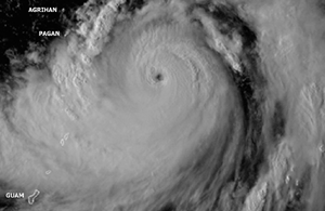
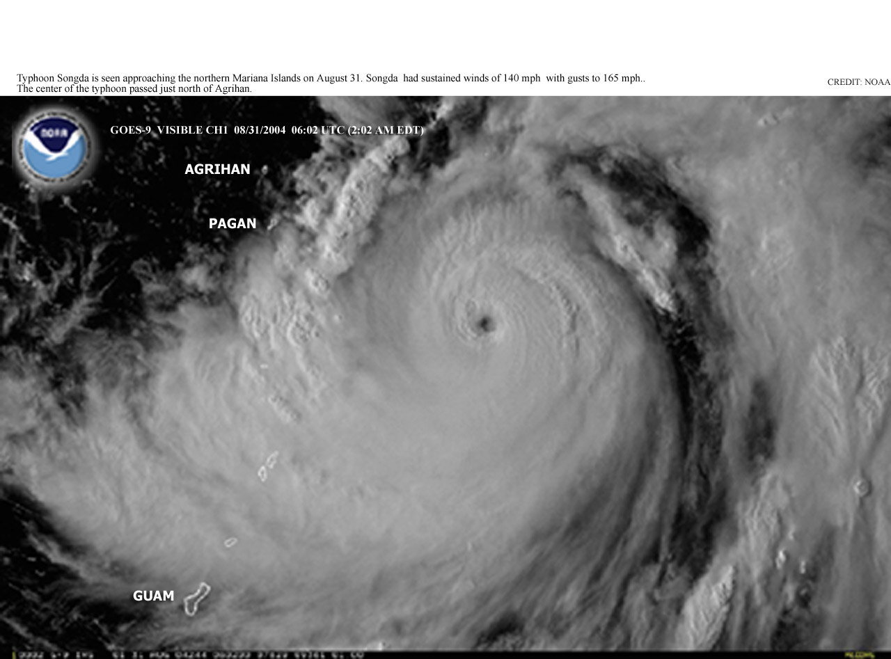
Typhoon Songda developed in
the western Pacific Ocean on August 27, and made landfall in
southern Japan on September 7 with maximum sustained winds near 165
km/hr (90 knots or 105 mph). Heavy rains and flooding accompanied
the typhoon as it weakened over the Sea of Japan by the 8th. |
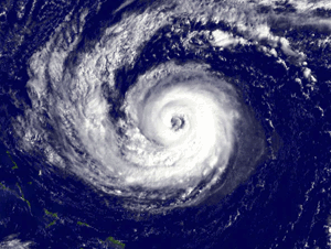
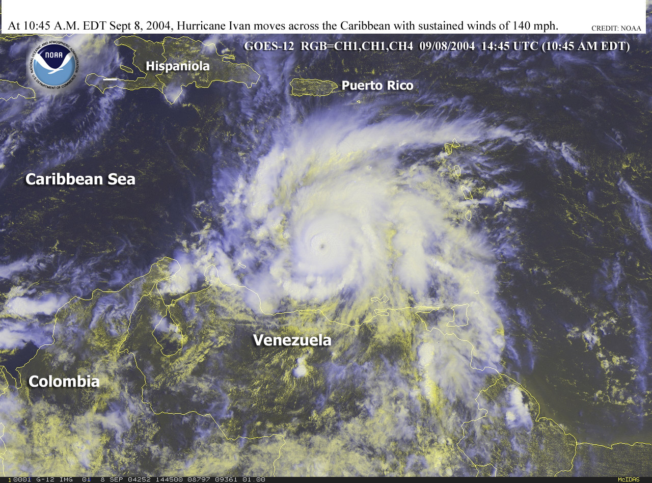
| Hurricane Ivan developed from a
tropical wave that emerged off the African coast at the beginning
of the month. Ivan reached hurricane intensity by the 5th and
proceeded westward into the Lesser Antilles and the Windward
Islands by the 7th as it reached
category-three intensity. |
 Larger
Image
Larger
Image
|
Ivan proceeded westward, crossing just south of the island of
Jamaica by the 10th-11th, then just south of Grand Cayman Island on
the 12th, and then brushing the western tip of Cuba on the 13th. On
its trek through the Caribbean, Ivan reached category-five
intensity during three separate periods in its life cycle.
Considerable destruction was reported throughout the affected
region, with 72 fatalities across the Caribbean (CNN/Associated
Press). On Grenada, 90 percent of the houses were damaged, while on
Grand Cayman, nearly every building had sustained some degree of
roof damage (OCHA).
| Ivan made landfall
along the Gulf Coast of the United States on the morning of the
16th, reaching the coastline near Gulf Shores, Alabama with maximum
sustained winds near 210 km/hr (115 knots or 130 mph). Significant
damage from winds and storm surge was reported along the coastline
of Mississippi, Alabama and the Florida panhandle, as offshore
buoys measured wave heights of 15 meters (50 feet). |
 Click For
Animation
Click For
Animation
|
Heavy rainfall and more than
100 tornadoes spread well inland into the interior Southeast,
Tennessee Valley and Mid-Atlantic regions. In western North
Carolina, around $200 million (USD) in damage was caused in
Buncombe County from the combined effects of Frances and Ivan in
the span of a two week period (Asheville Citizen-Times). At least
50 deaths in the United States were attributed to Ivan (Associated
Press).
The remnants of Ivan exited the Delmarva Peninsula and headed
south, crossing Florida and re-emerging in the Gulf of Mexico.
Ivan was
reclassified as a Tropical Storm by the 23rd and made a final
landfall just west of Cameron, Louisiana on the evening of the 23rd
with maximum sustained winds near 75 km/hr (40 knots or 45
mph).
A file containing selected rainfall totals from Hurricane Ivan
is
available.
A large (15MB) colorized infrared satellite animation of
Hurricane Ivan making landfall along the U.S. Gulf Coast
is available.
 Larger
Image
Larger
Image
|
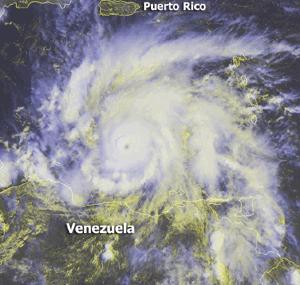
Hurricane Jeanne developed on
the 13th, passing over Puerto Rico on the 15th as a tropical storm.
Winds as high as 110 km/hr (60 knots or 70 mph) produced power
outages for most of the island's 4 million residents, left 600,000
people without running water, and was responsible for 2 deaths
(Associated Press). Jeanne reached hurricane strength by the 16th
just off the northeastern tip of the Dominican Republic, with
maximum sustained winds near 120 km/hr (65 knots or 75 mph). |
| Jeanne weakened
slightly as it tracked along the northern coast of Haiti, where
torrential
rainfall produced a flooding disaster that claimed 3,006 lives
(Reuters). The severity of the flooding and mudslides in Haiti was
exacerbated by the lack of trees, where over 98 percent of the land
is deforested (Associated Press). The majority of the fatalities
occured in the city of Gonaives. |
 Larger
Image
Larger
Image
|
 Larger
Image
Larger
Image
|
The hurricane moved
through the northwestern Bahamas on the 25th, crossing Abaco and
Grand Bahama Islands with winds sustained at 185 km/hr (100 knots
or 115 mph). The storm tore off roofs and severely damaged hundreds
of houses (Associated Press). Jeanne proceeded westward, making landfall
around midnight on the 26th (local time) near Stuart, Florida
with maximum sustained winds near 195 km/hr (105 knots or 120 mph).
Strong winds and torrential rains from the hurricane caused severe
damage as it tracked across Florida. Jeanne weakened but produced
heavy rainfall as it moved across Georgia, the Carolinas and into
the Mid-Atlantic states. Combined impacts of flooding and severe
weather (tornadoes) resulted in at least 10 fatalities in the
United States (Associated Press). |
In Florida, more than one out of every five houses received
damage this season from the unprecedented impacts of four
hurricanes (Charley, Frances, Ivan and Jeanne) (Insurance
Information Institute).
A large (11MB) colorized infrared satellite animation of
Hurricane Jeanne making landfall along the U.S. Gulf Coast is
available.
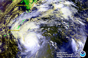
| Typhoon Meari formed in the
western Pacific Ocean on the 20th, reaching typhoon strength on the
22nd. Meari then moved across Japan, reaching the southern island
of Kyushu on the 29th with maximum sustained winds near 130 km/hr
(70 knots or 80 mph). The typhoon produced flooding and mudslides
that claimed at least 15 lives (AFP). It was the eighth typhoon to
directly hit Japan this season. |
 Larger
Image
Larger
Image
|
A table containing the
Accumulated Cyclone Energy (ACE) index for global tropical
cyclones occurring during the month of September 2004 is available.
For additional analysis of Tropical Storms and Hurricanes in the
Atlantic and Eastern Pacific Oceans, see the 2004 Hurricanes
page.
No reports of significant extratropical cyclones were received
during September 2004.

 Larger
Image
Larger
Image
|
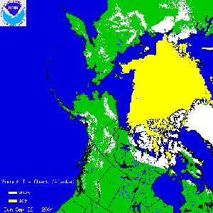
In Alaska, snowfall
totaled 15.2 cm (6 inches) in Anchorage on September 25, 2004. This
was the most snow ever recorded so early in the season and the
heaviest snowfall for any single day in the month of September. The
16 cm (6.3 inch) snowfall total for the month also made it the
snowiest September on record. |
References:
Basist, A., N.C. Grody, T.C. Peterson and C.N. Williams, 1998:
Using the Special Sensor Microwave/Imager to Monitor Land Surface
Temperatures, Wetness, and Snow Cover. Journal of Applied
Meteorology, 37, 888-911.
Peterson, Thomas C. and Russell S. Vose, 1997: An overview of
the Global Historical Climatology Network temperature data base.
Bulletin of the American Meteorological Society,
78, 2837-2849.
|


