Atlantic Basin
Four named storms formed in September, with an additional storm (Frances) that formed in August and made landfall in September in Florida.
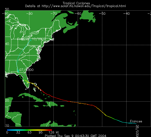
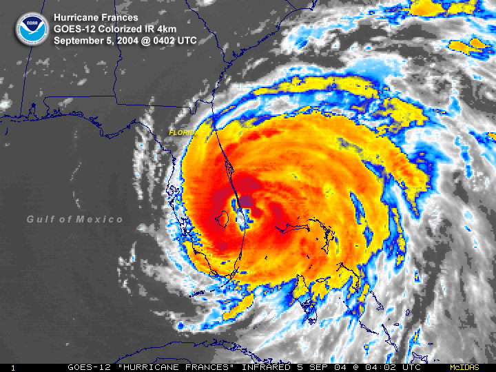
Details on the early stages of Frances can be found in the August report. Hurricane Frances was at category four strength (140 mph, 122 kts) as it moved towards the southeastern Bahamas, passing over the Turks and Caicos Islands on September 1st. The hurricane moved west-northwest across the central Bahamas over the next several days gradually diminishing in forward speed and fluctuating in intensity. By the afternoon of September 4th, Frances had stalled about 50 miles off the coast of Palm Beach Florida with windspeeds of 105 mph (91 kts).
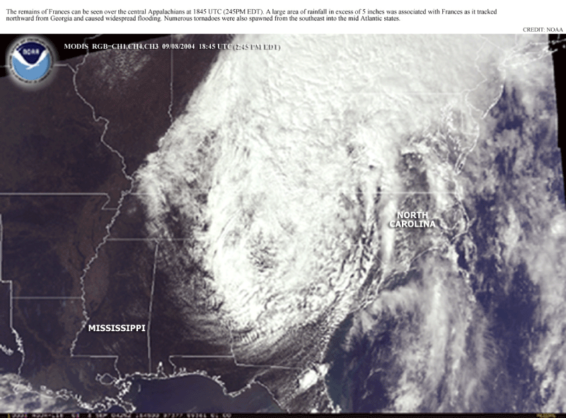
The eye finally made landfall in the U.S. early on the 5th near Sewall's Point, Florida with maximum sustained winds of 105 mph (91 kts), however, hurricane force winds had battered the coast for several hours before the eye came ashore. The storm weakened as it continued to move west-northwest across the Florida Peninsula and re-emerged over the Gulf of Mexico before making a second landfall on the 6th near St Mark's, Florida with windspeeds of 65 mph (56 kts). As Frances weakened to a tropical depression late on the 6th as it moved over Georgia, extensive flooding resulted from the storm. Over 15 inches (381mm) of rain fell in some locations as Frances moved up the Appalachian range and into the Northeast over the next several days. Locations from Georgia to New York suffered flood damage. For more details on the impacts of Frances, see the Hazards report.
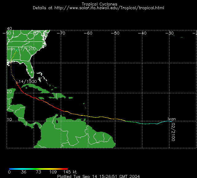
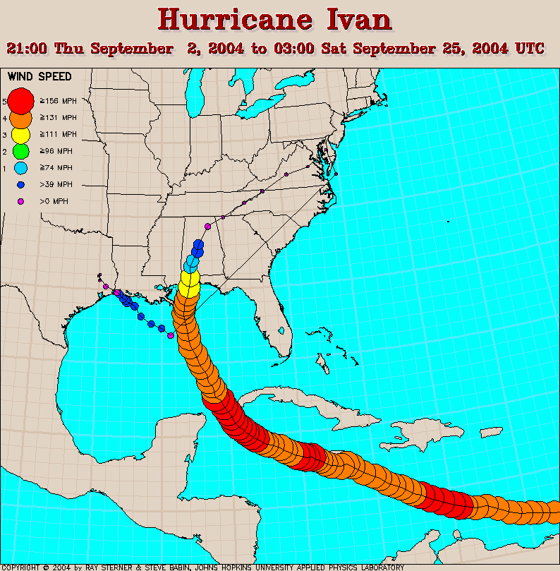
A ninth seasonal tropical depression was identified on September 2nd in the eastern tropical Atlantic. This developed into Tropical Storm Ivan on September 3rd. Ivan moved toward the west at about 9 degrees North and became a hurricane on September 5th. Later that same day, Ivan reached category 4 strength on the Saffir-Simpson scale, a major hurricane.
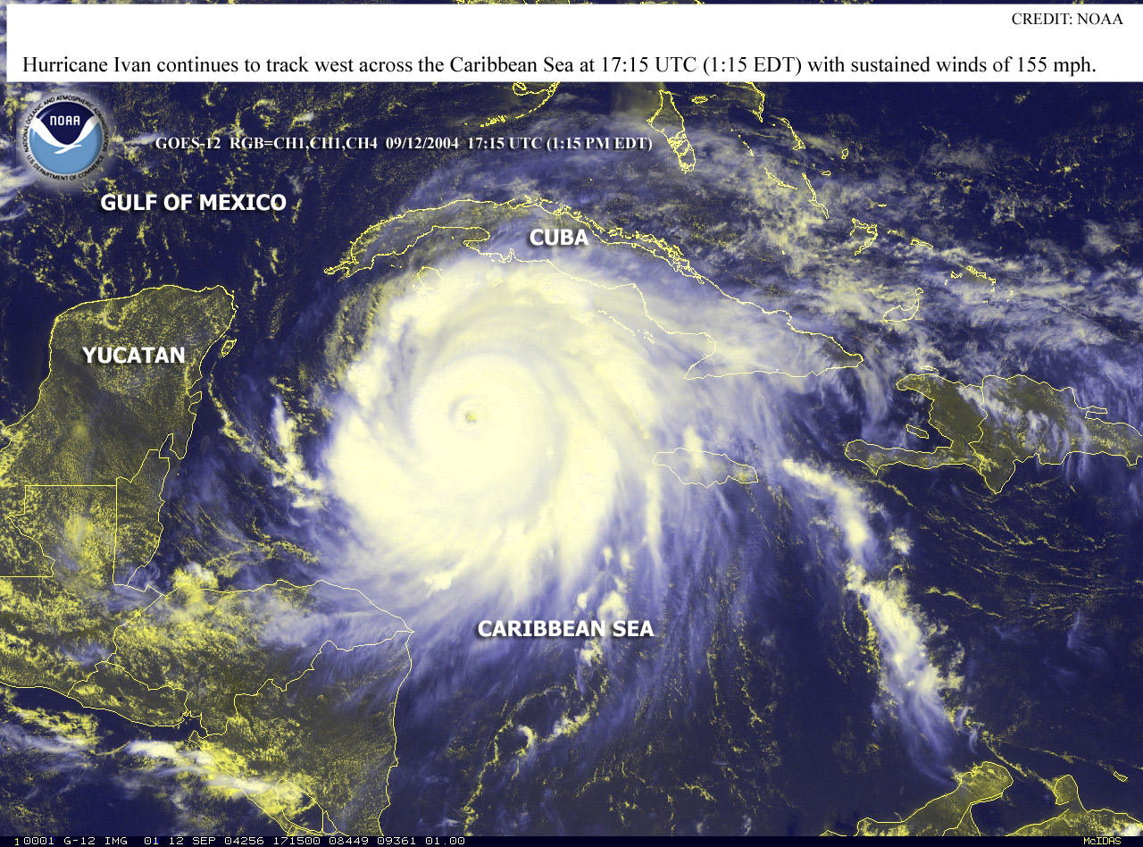
Ivan moved over Grenada on September 7th destroying much of the property there and strengthened to become a category 5 storm early on September 9th. Some fluctuations in intensity occurred with Ivan over the following several days and the eye tracked just offshore of southwest Jamaica on the 11th with windspeeds of 150 mph (130 kts), category 4. As the storm passed the Cayman Islands at category 5 strength on September 11th, considerable damage was again inflicted. Ivan remained at category 5 strength until September 12th when it weakened again to category 4, regaining category 5 intensity on the 13th.
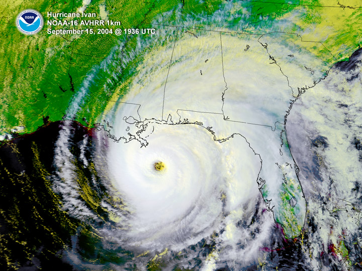
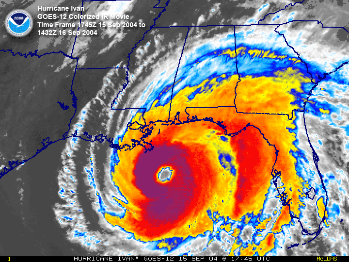
Hurricane Ivan passed the western tip of Cuba on the 13th and spent the next three days moving northwestward in the Gulf of Mexico, slowly weakening. Early on September 16th, Ivan made landfall as a category 3 storm near Gulf Shores, Alabama. The storm moved slowly northeastward across the southeastern US after landfall and weakened to an extratropical low as it moved offshore around the Delmarva Peninsula on the 19th. The remnants of Ivan continued to make a loop moving southwestward, then westward and crossing Florida into the Gulf of Mexico on September 21st. Ivan regained strength to reach tropical storm intensity, then made a second landfall over the extreme southwestern tip of Louisiana on the 24th. The storm dissipated over eastern Texas later the same day.
Damage from Ivan was severe in the southeastern US with widespread flooding. Selected rainfall totals from Ivan are available here. And more information on the impacts of the storm can be found in the Global Hazards report.
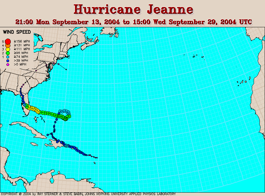
The tenth named tropical system of the Atlantic basin began as a tropical wave that developed into a tropical depression on September 13th just east of the Leeward Islands. Tropical Storm Jeanne formed on the 14th from that depression, as it moved north-northwest across the Leeward Islands. Over the next several days Jeanne moved west-northwest dumping huge amounts of rain over Puerto Rico, Haiti and the Dominican Republic. The storm briefly reached hurricane strength before weakening slightly while interacting with the high terrain of Hispaniola.
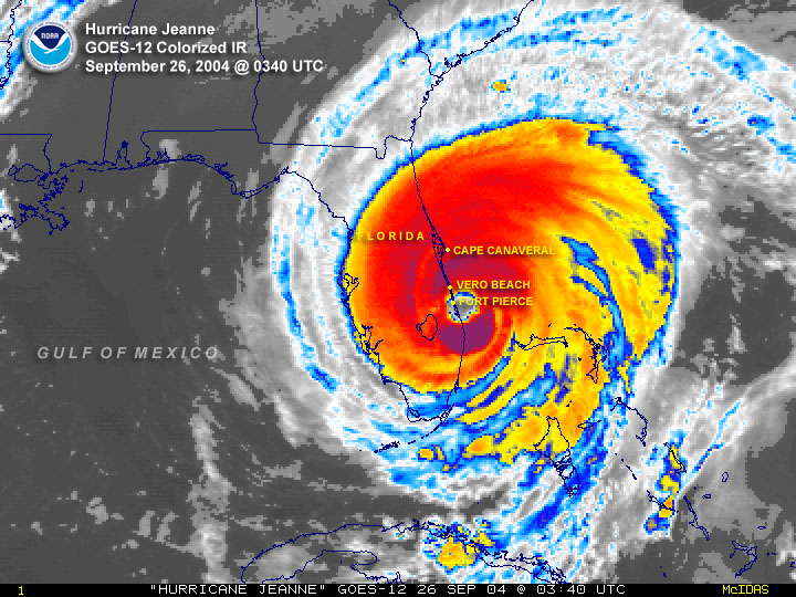
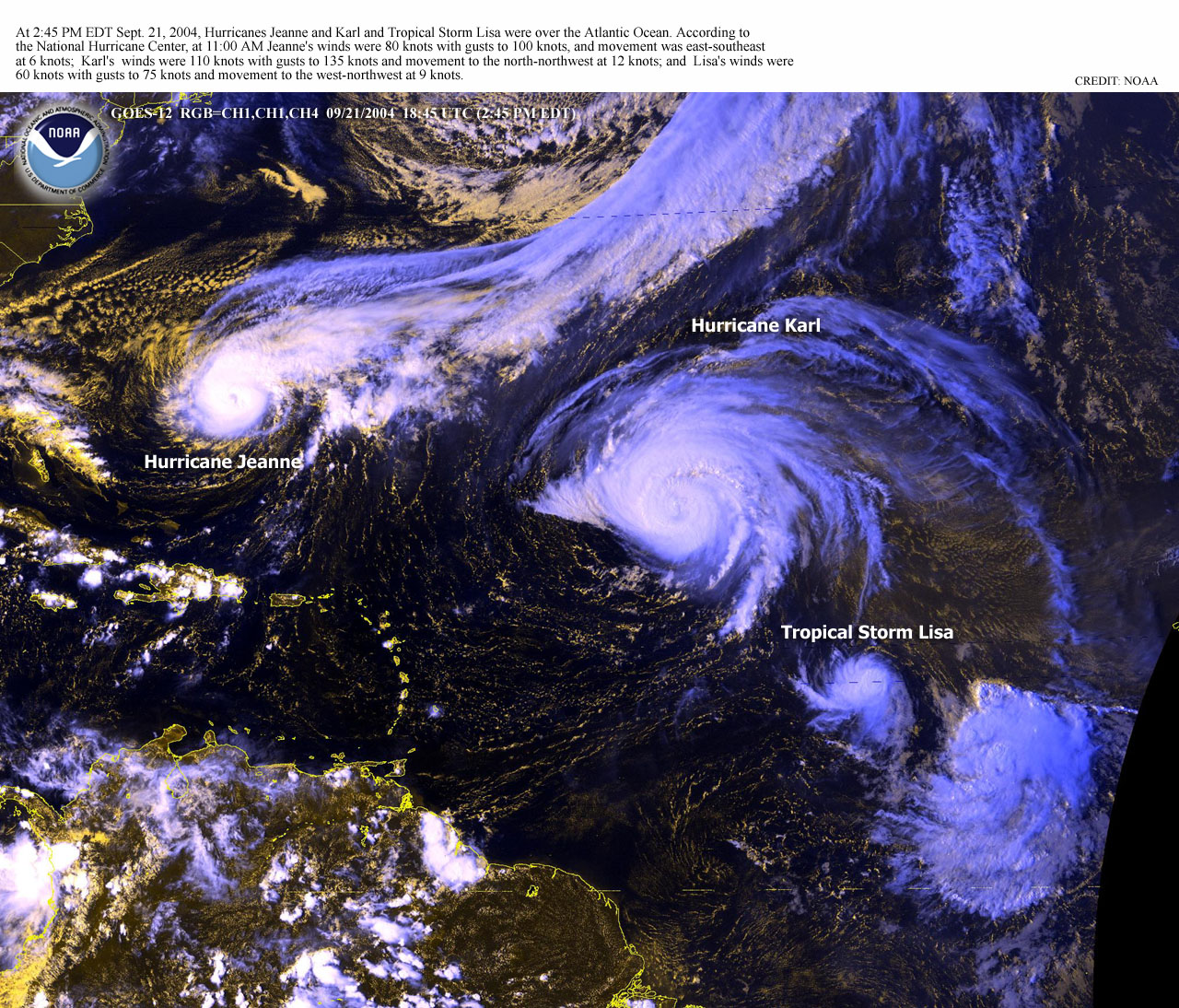
Jeanne then tracked northward on the 18th and became a hurricane on the 20th, reaching category two strength while making a clockwise loop in the western Atlantic. The hurricane began tracking westward on the 23rd, reaching Abaco Island and Grand Bahama Island in the northwestern Bahamas on the 25th, while at category 3 strength. Jeanne continued westward and made landfall at Stuart, Florida near midnight on the 26th with windspeeds of 120 mph (105 kts), category 3. The location of Jeanne's landfall was almost exactly the same as Hurricane Frances only 20 days earlier. The storm moved northwestward, then northward through Florida, weakening to a tropical storm and then tracked across Georgia and the Carolinas accompanied by heavy rain, finally exiting the coast, just east of New Jersey on the 29th.
Flooding caused by the rainfall from Jeanne was responsible for over 3000 deaths in Haiti. More details on Jeanne's impacts are available in the Global Hazards report.
Neither Hurricane Karl nor Hurricane Lisa impacted land during their lifetimes, though Karl became the 6th major hurricane of the 2004 season and Lisa became the 8th hurricane overall this year. Karl became a tropical storm in the eastern Atlantic developing from a tropical depression on September 17th. The storm became a hurricane the next day as it turned northwestward and then became a major hurricane on the 19th/20th. Maximum sustained winds reached an estimated 140 mph (kts) on September 21st as Karl turned north-northwestward.
Fluctuating in intensity Karl turned northward, then northeastward over the next couple of days. Eventually, Karl lost tropical characteristics on the 24th, approximately 935 miles northwest of the Azores.
Tropical Storm Lisa began life as a tropical depression on the 19th of September approximately 645 miles west-southwest of the Cape Verde Islands. Lisa became a tropical storm the next day as it moved westward, and then eventually turned northward on the 24th. Windspeeds in Tropical Storm Lisa intensified to 70 mph (61 kts) on September 30th as the storm moved slowly northward. Hurricane strength was briefly reached on October 1st for Lisa, though the storm began to weaken the next day in the far North Atlantic becoming extratropical about 475 miles north-northwest of the Azores.