National Overview

February Highlights
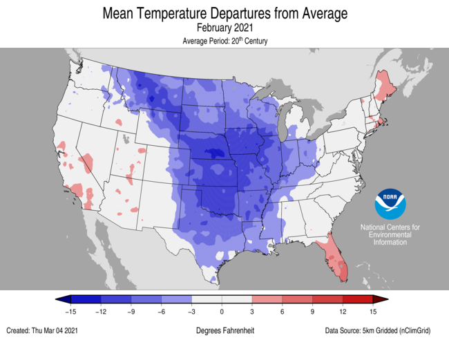
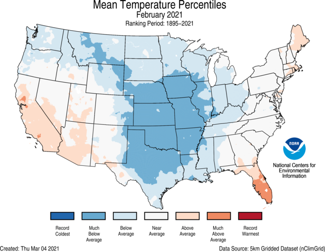
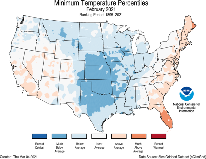
February Temperature
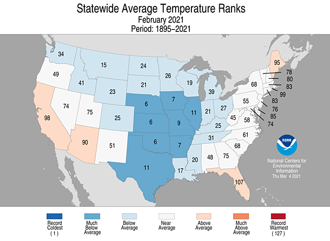
- The average contiguous U.S. temperature during February was 30.6°F, 3.2°F below the 20th century average. This ranked as the 19th coldest February in the 127-year period of record.
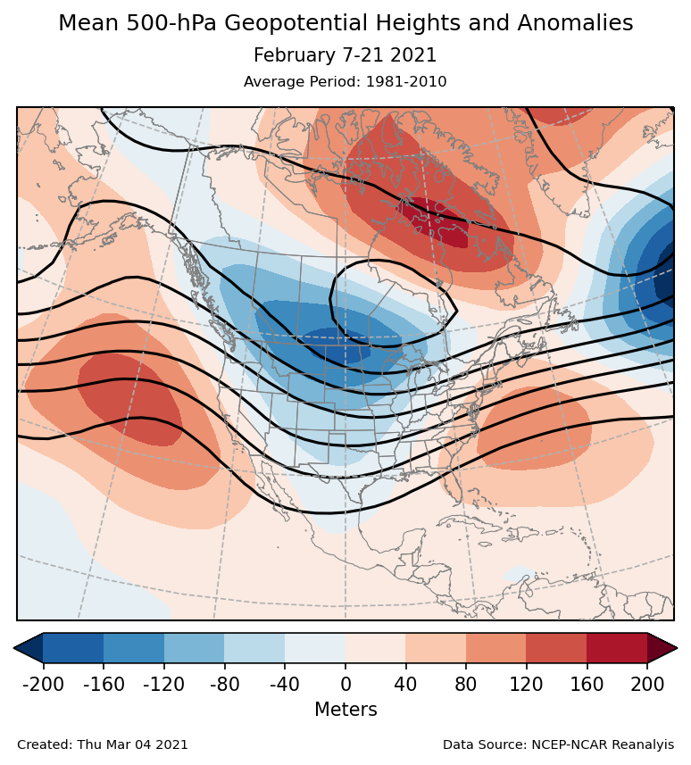
- The main driver for the weather across the contiguous U.S. during February was a strongly negative Arctic Oscillation (AO) during the first half of the month. This may have been the result of a sudden stratospheric warming event that occurred in January. The negative AO pattern favors a cold air outbreak over the central U.S., often referred to as a “polar vortex”. A blocking pattern disrupted the jet stream, which prolonged the duration of this cold event.
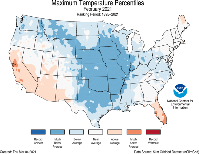
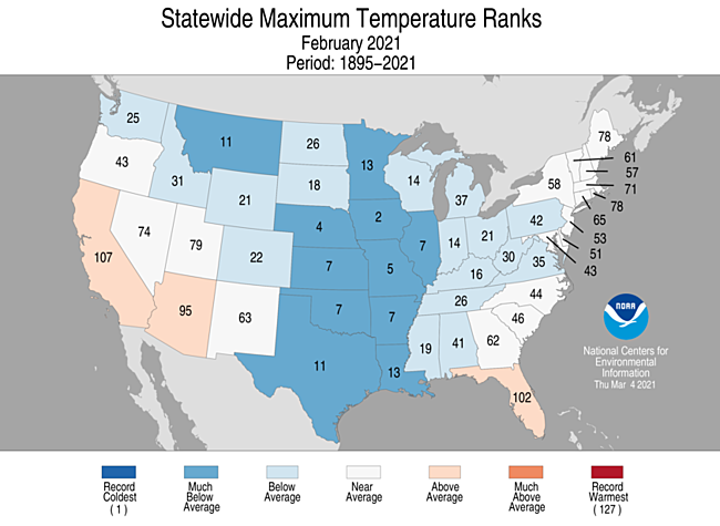
- Below-average temperatures dominated the Lower 48 and were observed from the Northwest to the Great Lakes and south to the Gulf of Mexico. Six states, Nebraska, Iowa, Kansas, Missouri, Oklahoma and Arkansas, ranked among their 10-coldest Februaries on record. Texas and Illinois ranked 11th coldest.
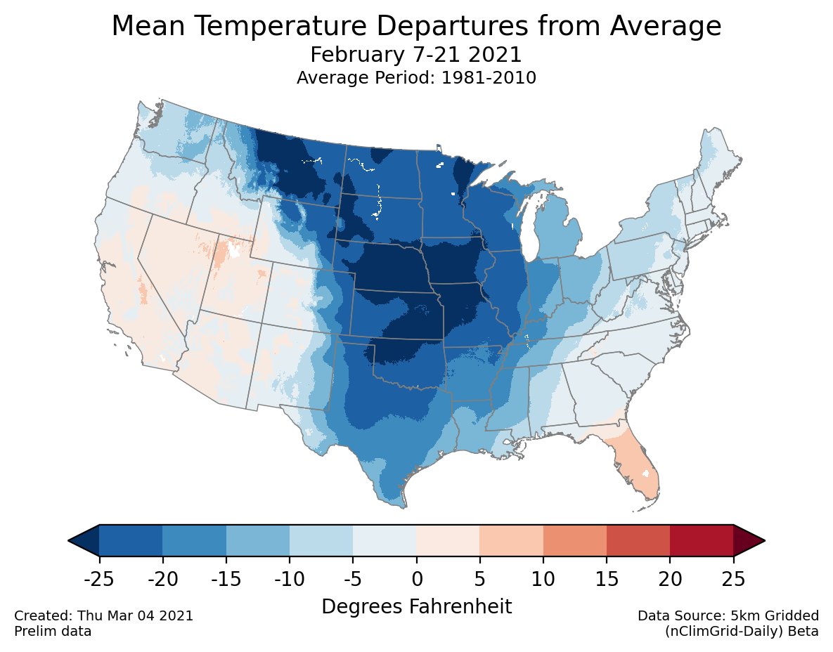
- From February 7-21, large areas with temperatures more than 25°F below average were evident from parts of the Northern Rockies and Plains to the central Plains. A station near Ely, Minnesota, bottomed out at −50°F on February 13 and 14. Several other stations in northern Minnesota reported low temperatures in the −40°F range on February 13.
- Based on preliminary data, 62 all-time daily cold minimum temperature records were broken from February 11-16 and 69 all-time daily cold maximum temperature records on February 15-16.
- Several locations across central Texas, including Austin and Waco, broke records for the longest freezing streak with temperatures below freezing between six and nine consecutive days from February 10-19.
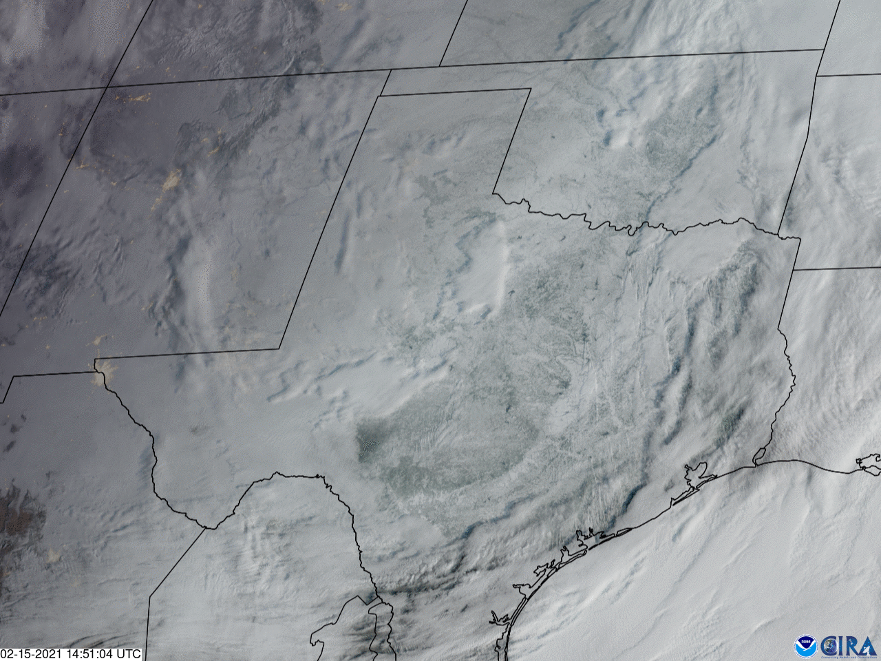
- Much of Texas endured the coldest air since December 23, 1989, during this period. Every county across Texas was under a Winter Storm Warning in mid-February. Wind chill values were below zero as far south as the Rio Grande River and into northeastern Mexico.
- Ice and snow cover stretched into south Texas and northeastern Mexico.
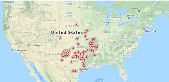
- Power outages, which were concentrated across Texas but widespread throughout much of the South, occurred over multiple days with sustained below-freezing temperatures. At the peak of the outage, nearly 10 million people were without power.
- The contiguous U.S. average maximum (daytime) temperature during February was 40.9°F, 3.9°F below the 20th century average, ranking 16th coldest on record. Above-average maximum temperatures were observed across parts of the West, Florida and Maine. Below-average daytime temperatures occurred from the Pacific Northwest to the Great Lakes, Mid-Atlantic and Gulf Coast. Iowa ranked second coldest while six additional states across the central U.S. ranked among their coldest 10 Februaries on record for maximum temperature.
- The contiguous U.S. average minimum (nighttime) temperature during February was 20.4°F, 2.4°F below the 20th century average, ranking 25th coldest on record. Above-average minimum temperatures were observed across portions of the West and along the East Coast. Below-average minimum temperatures dominated the northern Rockies, Plains, Great Lakes and the Mississippi River Valley.
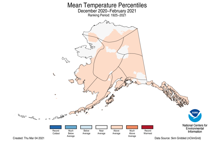
- The Alaska February temperature was 1.2°F, 3.6°F below the long-term average. This ranked among the coldest one-third of the 97-year period of record for the state and was the coldest February in 22 years.
- The North Slope had its coldest February in 31 years.
- The northern and eastern two-thirds of the state experienced below-average temperatures in February while the southwestern portion of the state, including the Aleutians, had temperatures near or above average for the month.
- Cold Bay ranked third warmest for February, and St. Paul was fourth warmest.
- The monthly high temperature for Anchorage reached a mere 30°F, making February 2021 the first month since December 1998 with all daily high temperatures remaining below freezing.
- Bering Sea ice extent in February was below average, resulting from persistent easterly winds and above-average sea-surface temperatures to the south.
- As of March 10, there were 1,429 record warm daily high (577) and low (852) temperature records in February, which was about 6.5 times less than the 9,361 record cold daily high (5,545) and low (3,816) temperature records.
- Based on NOAA's Residential Energy Demand Temperature Index (REDTI), the contiguous U.S. temperature-related energy demand during February was 23 percent above average and the 34th highest value in the 127-year period of record.
February Precipitation
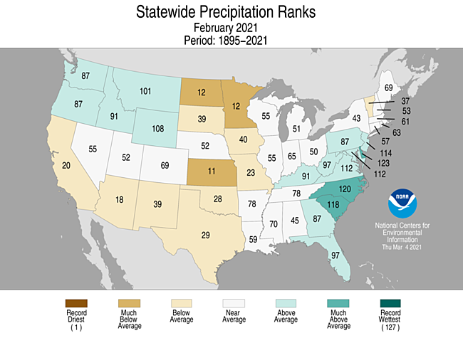
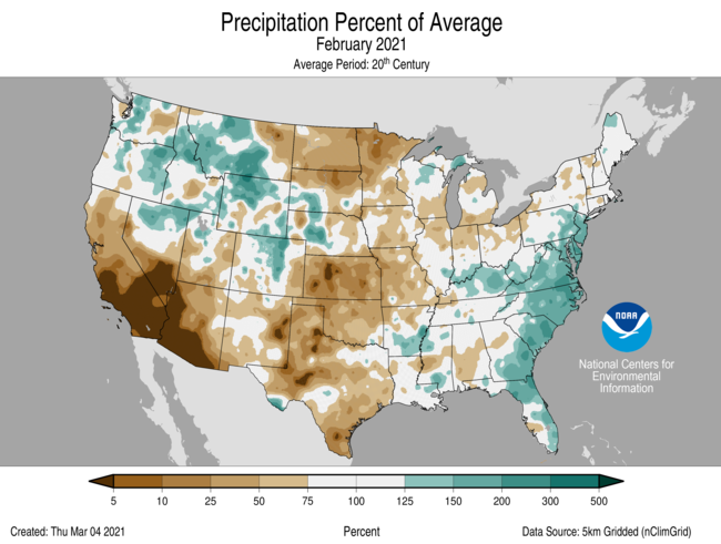
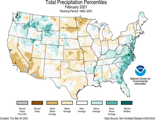
- The February precipitation total for the contiguous U.S. was 1.99 inches, 0.14 inch below average and ranked in the middle one-third of the historical period of record.
- Above-average wetness was present across much of the Northwest and portions of the East Coast and Ohio Valley. North Carolina ranked eighth wettest on record for the month while South Carolina ranked 10th wettest.
- Below-average precipitation was present across parts of the West, Plains, Great Lakes and Northeast. Kansas ranked 11th driest for February while Minnesota and North Dakota ranked 12th driest.
- From January 30-February 3, a powerful nor’easter moved up the Northeast coast and generated between 20 and 30 inches of snowfall across portions of eastern Pennsylvania, northern New Jersey and southern New York, breaking many daily snowfall records across the region. This storm was classified as a Category 3 on the Northeast Snowfall Impact Scale (NESIS) and was the biggest snowstorm in five years across much of the greater New York City metropolitan area.
- Contiguous U.S. snow cover reached 73.2 percent on February 16 — the highest daily value in the historical record (since October 2003). Snow blanketed the Sierra Nevada and much of the mountainous West. In addition, snow covered an area from northeastern Mexico and nearly all of Texas to the Great Lakes and east to the mid-Tennessee Valley and across the Northeast. This was also the highest daily snow cover value observed across the contiguous U.S. since 70.9 percent of the country was blanketed in snow on January 12, 2011.
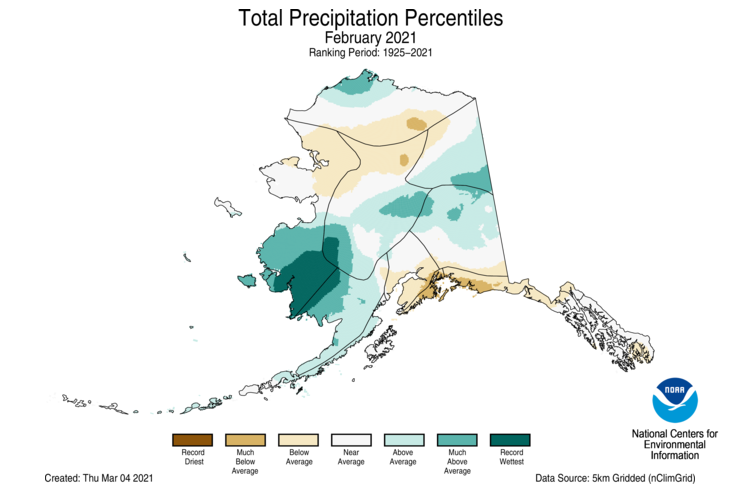
- Precipitation across Alaska varied regionally, with record-wet conditions across portions of the West Coast and Bristol Bay. Above-average precipitation was also observed across portions of the central Interior regions, North Slope and the Aleutians. Below-average precipitation occurred across parts of the northern Interior and Gulf regions.
- According to the March 2 U.S. Drought Monitor report, 46.6 percent of the contiguous U.S. was in drought, up from 45.8 percent at the beginning of February. Drought conditions expanded or intensified across portions of the northern and southern Plains, Great Basin and Puerto Rico. Improvements were observed across parts of the central Rockies, Midwest, Southeast, Pacific Northwest and Hawaii.
Winter Highlights
December-February Temperature
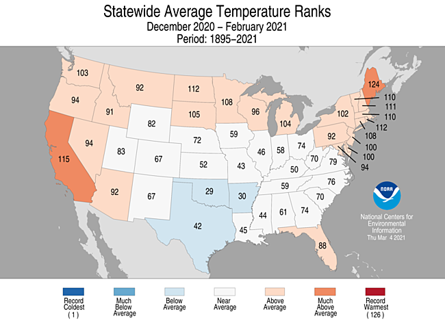
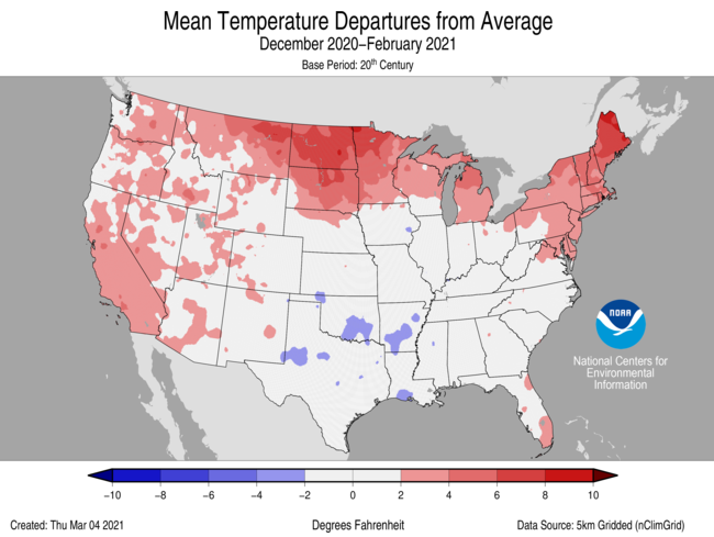
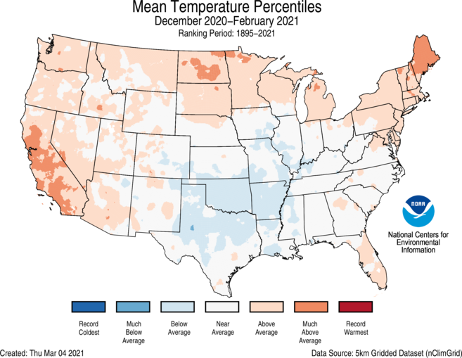
- The winter (December-February) average contiguous U.S. temperature was 33.6°F, 1.4°F above average, ranking in the warmest third of the winter record.
- Winter temperatures were above average across much of the West, Northern Tier, Northeast and parts of the Southeast. Maine ranked third warmest, and California ranked 12th warmest for this three-month period.
- Below-average temperatures were present across parts of the Midwest, lower Mississippi Valley and the southern Plains.
- The Alaska December-February temperature was 7.6°F, 4.0°F above the long-term average, ranking among the warmest one-third of the 96-year record. Above-average temperatures were observed across most of the state with pockets of near-average warmth across the North Slope, West Coast, central Interior and central Gulf Coast.
- The contiguous U.S. average maximum (daytime) temperature during December-February was 43.8°F, 1.1°F above the 20th century average, ranking in the warmest third of the historical record. Above-average conditions were observed across much of the West, northern Plains, Great Lakes, Northeast and parts of the Southeast. California ranked sixth warmest for the winter period. Below-average daytime temperatures were seen across portions of the central and southern Plains, Midwest and Ohio Valley.
- The contiguous U.S. average minimum (nighttime) temperature during December-February was 23.5F, 1.7°F above the 20th century average, ranking in the warmest third of the record. Above-average temperatures were observed across parts of the West, northern Plains, Great Lakes and East Coast. Maine ranked third warmest for the winter season. Below-average nighttime temperatures can be seen in parts of the Southwest and Deep South.
- Based on NOAA's Residential Energy Demand Temperature Index (REDTI), the contiguous U.S. temperature-related energy demand during the winter season was 67 percent of average and the 28th lowest value in the 126-year period of record.
December-February Precipitation
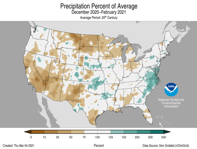
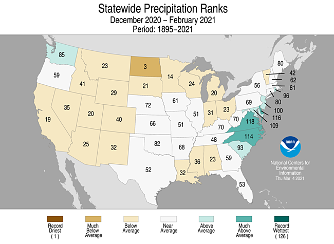
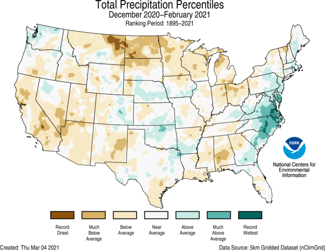
- The winter precipitation total for the contiguous U.S. was 6.10 inches, 0.69 inch below average, and ranked among the driest one-third of the 126-year period of record.
- Above-average precipitation was observed across parts of the Northwest, central Plains and East Coast. Virginia ranked ninth wettest while Delaware ranked 11th wettest for December-February.
- Many states from the West Coast to the Great Lakes and across the Gulf Coast experienced a dry winter season. North Dakota ranked third driest on record.
- For some parts of the country, snowfall was scarce during the winter months. Many locations across the northern Plains have seen a dearth of snowfall throughout the cold season and since the beginning of December. Glasgow, Montana, had its least snowy winter on record with 1.5 inches of snow observed since December 1. This eclipses the previous least snowy winter of 3.4 inches set in 1986-87. Records for Glasgow began in 1948.
- Climatologically speaking, winter is the wet season across much of the western U.S. If dry conditions continue in March and April across the Sierra Nevada range and much of the Southwest and central Rockies, insufficient water resources may occur through the dry season (summer) as well as an increased potential for drought intensification and wildfires this fall.
- While parts of the interior regions of Alaska experienced below-average winter precipitation, portions of the North Slope, West Coast, Bristol Bay, Northwest Gulf and the Panhandle regions had above-average- to record-wet conditions.
Extremes
-
The U.S. Climate Extremes Index (USCEI) for the winter season was 32 percent below average and ranked in the lowest third of the 111-year period of record. Extremes in nearly all indicators were below average with the exeption of dry PDSI values, which were nearly three times the historical average for this season. The USCEI is an index that tracks extremes (falling in the upper or lower 10 percent of the record) in temperature, precipitation and drought across the contiguous United States.
- On the regional scale, the Northeast, Southwest and West were the only regions to have CEI composite values above average for the winter season. Across the West, warm maximum temperatures and dry PDSI were elevated. For the Southwest, ongoing drought contributed to an elevated dry PDSI value. For the Northeast, warm minimum temperatures, wet PDSI and 1-day precipitation totals were elevated. The Ohio Valley ranked ninth lowest for CEI extremes during this winter season.
Regional Highlights
These regional summaries were provided by the six Regional Climate Centers and reflect conditions in their respective regions. These six regions differ spatially from the nine climatic regions of the National Centers for Environmental Information.
Northeast Region (Information provided by the Northeast Regional Climate Center)
- February 2021 was the first colder-than-normal month for the Northeast since May 2020. The region’s average temperature of 24.9 degrees F (-3.9 degrees C) was 1.4 degrees F (0.8 degrees C) below normal. Ten of the 12 Northeast states were colder than normal with average temperature departures ranging from 3.0 degrees F (1.7 degrees C) below normal in West Virginia to 1.0 degrees F (0.6 degrees C) above normal in Maine. The Northeast had its 20th warmest winter since 1895 with an average temperature of 27.7 degrees F (-2.4 degrees C), which was 1.0 degree F (0.6 degrees C) above normal. Eleven of the 12 states had a warmer-than-normal winter, with average temperature departures ranging from 1.0 degree F (0.6 degrees C) below normal in West Virginia to 4.0 degrees F (2.2 degrees C) above normal in Maine. This winter ranked among the 20 warmest on record for the six New England states: Maine, third warmest; New Hampshire and Rhode Island, 16th warmest; Massachusetts and Vermont, 17th warmest; and Connecticut, 20th warmest.
- The Northeast received 2.98 inches (75.69 mm) of precipitation, 108 percent of normal, during February. The states were split, with six being drier than normal and six being wetter than normal. Precipitation ranged from 82 percent of normal in Vermont to 197 percent of normal in Delaware, its fifth wettest February since 1895. In addition, New Jersey had its 14th wettest February, while Maryland had its 16th wettest. During winter, the Northeast received 9.67 inches (147.32 mm) of precipitation, 98 percent of normal. Five states were drier than normal, one state was at normal, and the remaining six states were wetter than normal. Precipitation ranged from 81 percent of normal in Vermont to 141 percent of normal in Delaware, its 11th wettest winter on record. In addition, Maryland had its 19th wettest winter.
- The U.S. Drought Monitor from February 2 showed 5 percent of the Northeast in a moderate drought and 14 percent of the region as abnormally dry. These areas included portions of northern New England, New York, and northern Pennsylvania. With just enough precipitation, below-normal temperatures, decent snowpack, and no noticeable impacts, conditions were unchanged for most areas during February. In fact, the only change was improvement of moderate drought in a sliver of northeastern New York. The U.S. Drought Monitor from February 23 showed 4 percent of the Northeast in a moderate drought and 14 percent of the region as abnormally dry.
- Storms moved through the Northeast frequently during February. A slow-moving nor’easter dropped snow on the entire region from February 1 to 3. Storm snow totals ranged from less than 6 inches (15 cm) to more than 24 inches (61 cm), with several locations in eastern Pennsylvania seeing over 30 inches (76 cm). Some sites, including Central Park, New York; Bridgeport, Connecticut; and Allentown, Pennsylvania, had one of their 10 all-time snowiest days on record. Snow fell at a rate of at least 3 inches (8 cm) per hour on New York’s Long Island, where some sites experienced blizzard conditions. In fact, areas closer to the coast reported wind gusts of 25 mph (11 m/s) to 64 mph (29 m/s). Minor to moderate coastal flooding occurred from Delaware to Massachusetts, eroding beaches and inundating roads and low-lying locations. Power outages and vehicle crashes were also reported. On February 7, another system produced snow for many areas. Portions of the Interstate 95 corridor from Pennsylvania to Massachusetts saw the greatest snow totals of 8 to 12 inches (20 to 30 cm). A series of storms moved through the Northeast in mid-February. A storm system from February 11 to 12 brought as much as 6 inches (15 cm) of snow and some ice accumulation from freezing rain, mostly in southern parts of the region. On February 13, southern parts of the region saw as much as 0.30 inches (0.76 cm) of ice accumulation from freezing rain, downing trees and disrupting travel. From February 15 to 16, the region saw several inches of snow and/or sleet and up to 0.50 inches (1.27 cm) of ice accumulation from freezing rain, causing hazardous travel conditions. In addition, 100,000 customers lost power in West Virginia. Another storm system from February 18 to 19 produced more snow and ice in the region. Snowfall totaled 8 inches (20 cm) or less in most areas except in parts of southeastern Pennsylvania and central New Jersey where as much as 11 inches (28 cm) accumulated. Southeastern West Virginia and parts of the Mid-Atlantic saw as much as 0.40 inches (1 cm) of ice accumulation from freezing rain, with lesser amounts in the New York City metro area. At the end of the month, from February 26 to March 1, as much as 4.75 inches (120.65 mm) of rain fell in portions of West Virginia. In fact, Huntington tied its wettest February day (and second wettest winter day) on record on the 28th with 2.83 inches (71.88 mm) of rain, while Charleston had its fourth wettest February day (and fifth wettest winter day) on record with 2.23 inches (56.64 mm) of rain. Widespread flooding led to closed roads, flooded buildings, evacuations and water rescues, and rockslides. A few waterways reached one of their 10 highest water levels on record. With frequent storms during the month, several major climate sites, particularly southern and coastal locations, saw an unusually high number of days with measurable snow, ranking among the ten greatest for February or on record. For instance, Baltimore, Maryland, had nine days with measurable snow during February, tying as the second greatest number for any month on record. February 2003 holds the record with 10 days. Similarly, Pittsburgh, Pennsylvania, had 16 days with measurable snow, which tied as the second greatest number for any February on record. In addition, Binghamton, New York, had its snowiest winter (December through February) on record with 94.3 inches (239.5 cm) of snow, beating the old record of 90.3 inches (229.4 cm) set in the winter of 1977-78.
- For more information, please visit the Northeast Regional Climate Center Home Page.
Midwest Region (Information provided by the Midwest Regional Climate Center)
- Extreme cold impacted the Midwest in February. Though the coldest conditions were centered further to the west, the Midwest also experienced very cold temperatures. The monthly average temperature for the region was 17.9 degrees F (-7.8 C) which was 8.6 degrees F (4.8 C) below normal. This ranked as the 16th coldest February for the region since 1895. Iowa had its 7th coldest February while Missouri ranked 9th, and Illinois 11th in their respective histories. The first week of the month was slightly below normal and then the real cold settled in for the next two weeks before a warmer week to end the month. More than 2,300 daily record-low maximum or minimum temperatures were set or tied from February 7th to the 18th. During the mid-month cold snap, temperatures were 20 to 30 degrees F (11.1 to 16.7 C) below normal at many locations in the western half of the region. Further east, average conditions were milder but still below normal and much of the region experienced temperatures that fell below zero degrees F (-17.8 C) on the 17th. Only large parts of Kentucky and areas along the Ohio River escaped the sub-zero temperatures on that date. The warmer temperatures in the last week of February moderated the monthly values somewhat. Winter temperatures were within 2.0 degrees F (1.1 C) of normal across nearly all of the region, with just a small area in northwestern Minnesota more than 2.0 degrees F (1.1 C) above normal for the season. Warm conditions in December and January offset the very cold conditions in February.
- Much of the Midwest was below normal for February precipitation. The average precipitation for the region was 1.42 inches (36 mm) which was 0.31 inches (8 mm) below normal. This ranked as the 46th driest February since 1895. Minnesota ranked as the 12th driest in its history. Kentucky, the only Midwest state with above-normal precipitation, ranked as the 37th wettest February in its history. Some areas with above normal precipitation for February included most of Kentucky, which got a drenching on the last few days of the month, along with northwestern Iowa, northern Wisconsin, and northern Michigan. The wettest area was in Eastern Kentucky with about twice the normal precipitation for the month and the driest area was northwestern Minnesota where many locations had less than 25 percent of normal. Snow totals were generally less than normal across Minnesota, slightly above normal in Wisconsin and western Michigan, and well above normal in southeastern Michigan and the other six Midwest states. Snow totals were two to five times normal for much of Missouri, Illinois, Indiana, Kentucky, and western and central Ohio. More than 350 daily snowfall records were set in February. Some monthly snowfall records were set including Salem, Illinois (97 years on record), Manistique, Michigan (79 years on record), and Martinsville, Indiana (77 years on record). Winter precipitation was below normal for most of the Midwest. A few areas including central and eastern Kentucky, southern Iowa, and northern and western Missouri had slightly above normal winter precipitation totals. Averaged over the region, precipitation totaled 4.78 inches (121 mm) which was 0.93 inches (24 mm) below normal. The Midwest winter ranked as the 31st driest since 1895. Winter snowfall was well above normal in Iowa, northern Illinois, and the Ohio River Valley and below normal in most of the northern areas. The lake-effect snow areas downwind of the Great Lakes were generally below normal for the winter.
- Seven stations in Kentucky reported over 4 inches of rain, including two with more than 6 inches. London Corbin Airport (Laurel County) reported 6.78 inches (172 mm) and Bowling Green Airport (Warren County) reported 6.16 inches (156 mm). Numerous highways were closed due to flooding and some water rescues were needed. Thirteen counties, mostly in eastern Kentucky, declared emergencies. Beattyville (Lee County), along the Kentucky River, had flood levels unseen since 1957.
- According to the US Drought Monitor, drought conditions were relatively steady in the Midwest in February (Figure 8). Drought areas in central Illinois and northwestern Indiana shrunk slightly in February, as did the areas in western Iowa. Drought areas in Minnesota remained nearly the same throughout February, however the areas of abnormally dry expanded to the east encompassing northeastern Wisconsin and Upper Michigan.
- For further details on the weather and climate events in the Midwest, see the weekly and monthly reports at the Midwest Climate Watch page.
Southeast Region (Information provided by the Southeast Regional Climate Center)
- Temperatures were near average to above average across much of the Southeast and Puerto Rico for the month of February. Monthly mean temperatures were within 2 degrees F (1.1 degrees C) of normal in over 60 percent of the 103 long-term (i.e., period of record equaling or exceeding 50 years) stations across the region, except in the Florida Peninsula where monthly mean temperatures were 3 to 5 degrees F (1.7 - 2.8 degrees C) above average. This warmth is due in part to the above average sea surface temperatures across the surrounding ocean waters for this time of year. Consequently, Miami, FL (1895-2021) observed its 4th warmest February on record, and West Palm Beach, FL (1888-2021) tied for its 6th warmest February. Daily maximum temperatures ranged from 5.2 degrees F (2.9 degrees C) above normal in Fort Pierce, FL (1901-2021) to 6 degrees F (3.3 degrees C) below normal in Richmond, VA (1871-2021). Likewise, daily temperature minimums ranged from 5.8 degrees F (3.2 degrees C) above average in West Palm Beach, FL (1888-2021) to 3.4 degrees F (1.9 degrees C) below average in Huntsville, AL (1894-2021). The warmest weather of the month occurred on the 27th -28th, as unusually warm and humid air surged northward ahead of an approaching cold front. Daytime maximum temperatures reached or exceeded 80 degrees F (26.7 degrees C) across portions of every state, except Virginia. Augusta, GA (1873-2021) and Columbia, SC (1887-2021) both set a new February and winter (DJF) daily maximum temperature record on February 28th at 88 and 86 degrees F (31 and 30 degrees C), respectively. In contrast, the coldest weather of the month occurred on February 3rd – 5th, as a continental high-pressure system ushered in unseasonably cold air from the northwest. Daily minimum temperatures fell below 25 degrees F (-3.9 degrees C) across portions of every state including Florida, with a few mountain locations dropping into the single digits F (-12.8 to -17.2 degrees C). Indeed, Jacksonville, FL (1871-2021) recorded a daily minimum of 23 degrees F (-5 degrees C) and Mt. Mitchell, NC (1925-2021) a daily minimum of 3 degrees F (-16 degrees C). Furthermore, as an unseasonably cold airmass spilled into the deep south on February 16th, Huntsville, AL (1894-2021; 19 degrees F (-7.2 degrees C)) observed its fourth coldest daily maximum temperature for the month.
- Precipitation varied across the region for February, with the wettest locations in Virginia, North Carolina, eastern South Carolina and southern Georgia, where precipitation totals were 150 to more than 200 percent of normal. There were 24 long-term stations that observed more than 7 inches (178 mm) of precipitation for February, including Ocracoke, NC (1957-2021; 2nd wettest) at 9.95 inches (253 mm) and Cape Hatteras, NC (1893-2021; 5th wettest) at 8.39 inches (213 mm). On the 18th and 19th, a low-pressure system tracked northward along the coasts of South Carolina, North Carolina and Virginia, producing moderate rainfall across the eastern portions of the region. As a result, Florence, SC (1948-2021) received 2.39 inches (61 mm) of precipitation in 1-day, making it the 4th wettest February day on record. In contrast, driest locations were found across Alabama and northern Georgia, where precipitation totals were 50 to less than 25 percent of normal, although no stations ranked within the top 10 driest for the month. Athens, GA (1857-2021) only received 3.21 inches (82 mm) of precipitation, which was 1.7 inches (43 mm) below normal. Precipitation in Puerto Rico and the US Virgin Islands was near average for the month, with most stations observing totals within .75 inches (19 mm) of normal. A strong low-pressure system tracked eastward across the region brought over 3 inches (76 mm) of snow to parts of Alabama and freezing rain to parts of Virginia and North Carolina on February 17th -19th. Muscle Shoals, AL (1893-2021) measured 4.5 inches (114 mm) of snow and Huntsville, AL (1894-2021) 3.1 inches (79 mm). Richmond, VA (1871-2021) observed .25 inches (6 mm) of ice and parts of Hanover County, VA reported .40 inches (10 mm) of ice. There were over ten thousand customers without power, and Virginia State Police responded to 385 traffic crashes and 255 disabled vehicles due to the storm. The highest snowfall total in the region for the month was observed at Hot Springs, NC with 19.7 inches (500 mm).
- There were 61 reports of severe weather across the Southeast during February, which is 72 percent of the median monthly frequency of 85 reports during 2000-2019. There were 7 confirmed tornadoes reported for the month (5 EF-0, 1 EF-2, and 1 EF-3), 78 percent of the monthly average of 9. About 5 of these tornadoes were associated with a line of thunderstorms with embedded supercells that developed ahead of a cold front, corresponding with a low-pressure system that tracked northeastward through Georgia, South Carolina and North Carolina on February 15th. The most damaging tornado was rated an EF-3 with winds of 160 mph (72 m/s) and occurred in Brunswick County, NC. The tornado first touched down near Sunset Beach, damaging a number of trees and moved northeastward then increased in strength and destroying a large number of well-built brick homes in the Ocean Ridge Plantation subdivision. There were three fatalities and ten injuries associated with this tornado. This was the strongest tornado on record and the only tornado to cause fatalities within Brunswick County. Another tornado, rated EF-2 with winds of 130 mph (58 m/s), destroyed two homes and damaged trees, causing five injuries in Damascus, GA. There were 11 reports of hail for the month, with the largest being golf ball sized (1.75 inches) in Johnson County, GA. There were 43 wind reports for the month, which is 67 percent of average (64 reports). Strong winds were observed with the low-pressure system on February 15th, including 76 mph (34 m/s) gusts in Panama City Beach, FL and Romar Beach, AL. Strong winds were also observed across the region on February 22nd, with the strongest reported gust at 77 mph (34 m/s) in Tangier, VA. There were over several reports of trees and powerlines downed.
- The coverage of abnormally dry conditions (D0) decreased across Georgia and Florida, with a few small pockets remaining by the end of the month. Moderate drought (D1), however, expanded in coverage across central Alabama due to below-average precipitation. Near average amounts of precipitation kept drought conditions at the same levels in Puerto Rico, with an area of moderate drought (D1) ringed by an area of abnormally dry conditions (D0) on the northern portion of the island. In Florida, pasture conditions declined at the beginning of the month due to frosts and overall cold conditions. As temperatures rose later in the month, conditions improved across the state, as pastures started to green back up. Sugarcane harvest continued in the southern peninsula with minimal damage reported from frost. In Georgia, frequent rain events saturated soils, and prevented farmers from getting into their fields across the state for much of the month. Small grains and winter wheat were in need of additional fertilizer, but wet conditions prevented farmers from applying it, which led to nutrient deficiencies in many areas. Pest pressure was limited in the state due to the cold temperatures. Producers in northern Alabama struggled with ice and snow that delayed fieldwork and made providing feed and water to livestock difficult. However, hay stocks remained adequate, despite hay consumption being greater than normal due to below-average temperatures. Heavy rain events in South Carolina kept growers out of fields and forced livestock producers to manage pasture and feed areas more intensively to reduce mud and increase drainage. Wet conditions delayed small grain and pasture fertilizer topdressing. Wheat growth lagged and is in need of sunshine and warmth to catch up to historic norms. Many producers reported livestock health problems related to excessive rain and cool temperatures. Similarly, in North Carolina, the cold and wet weather led to muddy field conditions and nutrient deficiencies for small grains and wheat.
- For more information, please visit the Southeast Regional Climate Center Home Page.
High Plains Region (Information provided by the High Plains Regional Climate Center)
- The coldest air in decades invaded the central U.S. in mid-February, breaking many temperature records and taking a toll on the nation’s power grid. On the 16th, temperature departures exceeding 40.0 degrees F (22.2 degrees C) below normal occurred from Nebraska southward to Texas. From an east-west perspective, bitter cold stretched from the Continental Divide eastward to include much of the Midwest and southern states. While numerous daily temperature records were broken on the 16th, it was the longevity of the cold snap that was particularly impressive. Extreme cold persisted for 1-2 weeks, and the majority of the central U.S. remained below freezing during that time. Given the severity, duration, and spatial extent of the event, the energy demand for heating overwhelmed the power grid, prompting rolling blackouts in many states. The Southwest Power Pool, which serves much of North Dakota, South Dakota, Nebraska, and Kansas, was adversely impacted by the event. In addition to rolling blackouts, residents were asked to conserve energy until temperatures moderated. It is worth noting that Texas was most impacted by the extreme cold, as millions of people were left without power for days, and some residents had no water due to pipes bursting underground. It is anticipated that recovery from this event, which was declared a major disaster in Texas, will take quite some time.
- In addition to the cold, other adverse weather conditions increased the occurrence of avalanches and fires in February. According to The Denver Post, avalanche forecasters said that the avalanche danger is extremely high this season for the Rockies, mostly due to a bottom layer of snow that fell in October and was weakened by dry conditions in November. As new snow continues to build, the avalanche risk increases. Two men were killed by avalanches in Colorado. Fires were also an issue in February, particularly in drought-stricken areas of Colorado and Kansas where there was little snow cover. Increasing dryness and the lack of snow cover in western North Dakota prompted the National Weather Service in Bismarck to begin issuing their fire weather products unusually early.
- Temperature:
- February was quite cold for the majority of the High Plains region. With the exception of southwestern Wyoming and the western half of Colorado, where temperatures were near to slightly above normal, the region experienced temperature departures ranging from 6.0-15.0 degrees F (3.3-8.3 degrees C) below normal. This February was among the coldest on record for numerous locations.
- The lingering cold snap in the middle of February was primarily responsible for below-normal average temperatures for the month. This bitterly cold Arctic air mass remained in place for nearly two weeks, breaking many daily records for both lowest minimum and maximum temperature. Several locations experienced their lowest February temperature on record, including Goodland, KS (-24.0 degrees F (-31.1 degrees C)), Hastings, NE (-30.0 degrees F (-34.4 degrees C)), and Lincoln, NE (-31.0 degrees F (-35.0 degrees C)). Looking at all months, Hastings tied for its coldest temperature ever recorded, while it was the 2nd coldest for Lincoln and 3rd coldest for Goodland.
- As for the winter season, temperatures were 2.0-6.0 degrees F (1.1-3.3 degrees C) above normal throughout a large portion of the Dakotas, while the rest of the High Plains had near-normal temperatures. Sisseton, South Dakota had its 4th warmest winter on record, while Mobridge, South Dakota had its 8th warmest (Sisseton period of record 1931-2021, Mobridge period of record 1911-2021). However, average winter temperatures masked the extremes that occurred, as December and January were extremely warm for much of the region, while February was extremely cold.
- Precipitation:
- It was a mix of wet and dry conditions throughout the High Plains in February. Areas of the Dakotas and Kansas were especially dry, receiving less than 25 percent of normal precipitation. On the other hand, pockets of wetness existed throughout northern Wyoming, central Colorado, southwestern South Dakota, and several areas of Nebraska where precipitation exceeded 150 percent of normal. Sheridan, Wyoming had its 3rd wettest February on record, while it was the 6th wettest February for North Platte, Nebraska (Sheridan period of record 1907-2021, North Platte period of record 1874-2021).
- As for snow, some areas of the High Plains experienced a very snowy month, while others missed out. For instance, several storm systems brought snow to portions of Wyoming, Colorado, and Nebraska throughout the month. The snow was very welcome in Wyoming and Colorado, as mountain snowpack was lagging behind this season, and the snows helped these areas to catch up. In Nebraska, a winter storm that came through early in the month brought impressive snow totals. North Platte, Nebraska received 13.3 inches (34 cm) of snow from the 5th to the 7th, which was its highest 3-day total snowfall on record for February. Several locations broke into the top 10 of snowiest Februaries. However, snowfall was below normal in some areas, especially in the Dakotas and western Kansas. For instance, Aberdeen, South Dakota received only 0.6 inch (2 cm) of snow the entire month, which was 6.2 inches (16 cm) below normal. Also, major winter wheat growing areas in the region were largely snow-free when bitter cold settled in early in the month, leaving winter wheat vulnerable. While it is likely that there was damage to winter wheat, the full extent of the damage will not be realized until the spring.
- The winter season (December-February) was very dry for the Dakotas, northern and western Kansas, and the Nebraska Panhandle, while parts of Nebraska and Colorado were quite snowy. The following locations ranked among the top 10 driest winters on record: Chadron, NE (6th driest), Williston, ND (7th driest), Mobridge, SD (tied for 9th driest), and Grand Forks, ND (10th driest). Locations ranking among the top 10 snowiest winters on record included Lincoln, NE (snowiest), Omaha, NE (tied for snowiest), Hastings, NE (5th snowiest), North Platte, NE (5th snowiest), Grand Island, NE (6th snowiest), and Colorado Springs, CO (8th snowiest).
- Several snowstorms moved across the Upper Missouri Basin region in February, boosting mountain snowpack. According to the U.S. Army Corps of Engineers, as of March 1st, Snow Water Equivalent (SWE) was 94 percent of average above Fort Peck Reservoir as well as between Fort Peck and Garrison Reservoirs. Colorado and Wyoming were also fortunate enough to receive ample moisture, as SWE improved to 94 percent of median in Wyoming and 86 percent of median in Colorado. Plains snowpack varied throughout the month. At the beginning of February, snow covered the eastern Dakotas and central and eastern Nebraska, while the western Plains were largely snow-free. However, by mid-February, an active weather pattern had brought snow to much of the Plains, except for portions of the Dakotas. Then, a rapid warmup melted much of the snow by the end of the month.
- On the whole, drought conditions improved slightly in the High Plains in February. According to the U.S. Drought Monitor, the area experiencing drought (D1-D4) decreased from approximately 86 percent to 82 percent over the course of the month. However, the area experiencing abnormal dryness and drought (D0-D4) remained nearly the same at 93 percent.
- A continued lack of snowfall across western portions of the Dakotas prompted a large expansion of severe drought (D2) in this area. Several impacts to livestock and ranching were reported, including the use of supplemental feed, overgrazed winter pastures, and little water for livestock. There is growing concern that hay supplies will be limited in the spring. An increasing risk for wildfire was also reported. Conditions worsened in northern and western Wyoming as well, as continued dryness caused mountain snowpack to fall further behind the average for this time of the year.
- However, there were also widespread improvements in drought conditions in February. Several snowstorms traversed the region, easing conditions in portions of Nebraska, Kansas, Colorado, and Wyoming. The greatest improvements occurred in northeastern Kansas, where moderate drought (D1) and abnormal dryness (D0) were erased, and the Nebraska Panhandle extending westward into eastern Wyoming, where extreme drought (D3) improved to D1. The Rockies in Colorado received a boost in snowpack in drought-stricken areas in February, improving conditions in areas experiencing exceptional drought (D4) and D3.
- For more information, please visit the High Plains Regional Climate Center Home Page.
Southern Region (Information provided by the Southern Regional Climate Center)
- Temperatures for the month of February were below normal across the Southern Region, with the greatest departures from normal in the northwestern parts of the region. Parts of eastern Tennessee as well as western Texas experienced temperatures 0 to 2 degrees F (0.00 to 1.11 degrees C) below normal. Parts of eastern and central Tennessee, eastern and southern Mississippi, southeastern and southwestern Louisiana, and southeastern, southern, and western Texas experienced temperatures 2 to 4 degrees F (1.11 to 2.22 degrees C) above normal. Parts of central Tennessee; northeastern, central, and southwestern Mississippi; northern, central, and southern Louisiana; and eastern southern, central, and western Texas experienced temperatures 4 to 6 degrees F (2.22 to 3.33 degrees C) below normal. Parts of western Tennessee; northern and southern Louisiana; northwestern Mississippi; southern Arkansas; and eastern, central, western, and northern Texas experienced temperatures 6 to 8 degrees F (3.33 to 4.44 degrees C) below normal. Parts of western Tennessee, northwestern Mississippi, eastern and western Oklahoma, northern, central, and eastern Texas, and most of Arkansas experienced temperatures 8 to 10 degrees F (4.44 to 5.56 degrees C) below normal, while parts of central and eastern Arkansas, northern Texas, and most of Oklahoma experienced temperatures 10 degrees F or more (5.56 degrees C or more) below normal. The statewide monthly average temperatures were as follows: Arkansas – 35.20 degrees F (1.78 degrees C), Louisiana – 48.10 degrees F (8.94 degrees C), Mississippi – 44.00 degrees F (6.67 degrees C), Oklahoma – 31.30 degrees F (-0.39 degrees C), Tennessee – 37.60 degrees F (3.11 degrees C), and Texas – 44.20 degrees F (6.78 degrees C). The statewide temperature rankings for February were as follows: Arkansas (seventh coldest), Louisiana (seventeenth coldest), Mississippi (twentieth coldest), Oklahoma (sixth coldest), Tennessee (thirty-first coldest), and Texas (eleventh coldest). The region as a whole experienced its thirteenth coldest February on record. All state rankings are based on the period spanning 1895-2021.
- Precipitation values for the month of February varied spatially across the Southern Region. Parts of northwestern and northern Arkansas; northern Louisiana; central Mississippi; northern, western, central, eastern, and southern Texas; and most of Oklahoma received 50 percent or less of normal precipitation. Parts of northwestern Arkansas, northeastern and northwestern Oklahoma, and northern, central, western, and southern Texas received 25 percent or less of normal precipitation, while parts of central, western, and southern Texas received 5 percent or less of normal precipitation. In contrast, parts of southern and eastern Arkansas, southern Mississippi, central and western Texas, and western and eastern Tennessee received 130 percent or more of normal precipitation, while parts of western Texas, southern and eastern Arkansas, western Tennessee, and northern and southern Mississippi received precipitation 150 percent or more of normal. The statewide precipitation totals for the month were as follows: Arkansas – 3.88 inches (98.55 mm), Louisiana – 4.24 inches (107.70 mm), Mississippi – 5.09 inches (129.29 mm), Oklahoma – 0.82 inches (20.83 mm), Tennessee – 4.60 inches (116.84 mm), and Texas – 0.90 inches (22.86 mm). The statewide precipitation rankings for February were as follows: Arkansas (fiftieth wettest), Louisiana (fifty-ninth driest), Mississippi (fifty-eighth wettest), Oklahoma (twenty-eighth driest), Tennessee (fiftieth wettest), and Texas (twenty-ninth driest). The region as a whole experienced its sixtieth driest February on record. All state rankings are based on the period spanning 1895-2021.
- Drought and Severe Weather:
- At the end of February, drought conditions primarily deteriorated across the Southern Region. Exceptional drought conditions persisted across western and northwestern Texas, but the total area experiencing exceptional drought conditions in western Texas shrank. Extreme drought conditions persisted across parts of western, northwestern, and southern Texas as well as southwestern Oklahoma, with a slight increase in southern Texas. Severe drought classifications developed or expanded across parts of northern, northeastern, southern, and western Texas. Moderate drought classifications expanded or developed across parts of eastern Tennessee, northeastern and southern Louisiana, western and southeastern Oklahoma, and northern, northeastern, central, and southern Texas, while moderate drought conditions persisted across parts of Tennessee, Mississippi, Oklahoma, and Texas. There was an increase in the total area experiencing abnormally dry conditions, as abnormally dry conditions developed across northern and eastern Mississippi, northeastern and southwestern Louisiana, northern and southeastern Arkansas, southern and western Oklahoma, and eastern, central, southern, and northern Texas. However, abnormally dry conditions reduced or were eliminated across parts of west-central Texas and southern Louisiana.
- The Southern Region was exposed to extreme cold temperatures during the month of February due to an Arctic air outbreak. From February 12-19, parts of Oklahoma, Texas, and Arkansas experienced temperatures at or below 32 degrees F (0 degrees C) for at least 168 consecutive hours. On February 15, the average temperature across Oklahoma was 40 degrees F below normal, while the average temperature in Texas was such that it was the state’s third-coldest day on record. On February 16, every station in the Oklahoma Mesonet reported temperatures below 0 degrees F (-17.78 degrees C) at the same time, the first time this has occurred in the network’s history. Additionally, a wind chill of -36 degrees F (-37.78 degrees C) was reported in the Oklahoma Panhandle, while Oklahoma also recorded its coldest 2-day and 3-day period on record. Elsewhere, the Mississippi Lower Delta region reported ice accumulation between 0.50-0.75 inches (12.70-19.05 mm). Between February 12-21, just under 3,000 daily low temperature records were tied or broken (1,516 daily low maximum temperature records, 1,367 daily low minimum temperature records).
- In February, there were approximately twenty-eight severe weather reports across Arkansas, Louisiana, Mississippi, Oklahoma, Tennessee, and Texas. There was one tornado report, thirteen hail reports, and fourteen wind reports. Texas had the most hail reports (6) while Tennessee had the most wind reports (8). Tennessee had the most reports (12) while Louisiana and Oklahoma had the fewest (2). Only one state (Louisiana) reported a tornado, while two states did not report hail (Arkansas and Louisiana) or wind (Oklahoma and Texas). All twenty-eight reports occurred on three days (February 10, 25, and 28).
- On February 10, 2021, there was a report that homes and buildings were completely destroyed by strong winds near Shreveport, Louisiana.
- On February 25, 2021, lime-sized hail was reported near Bogata, Texas.
- On February 28, 2021, there were twenty-two severe weather reports across Arkansas, Louisiana, Mississippi, Oklahoma, Tennessee, and Texas. An EF-1 tornado was reported near Vivian, Louisiana. Two injuries were reported in Tennessee due to strong winds, with one person rescued after being trapped while another person was injured after coming into contact with a downed power line. A wind gust of 67 mph (107.83 kph) was reported near Joiner, Arkansas.
- For more information, please visit the Southern Regional Climate Center Home Page.
Western Region (Information provided by the Western Region Climate Center)
- February brought a characteristically La Niña-like precipitation pattern to the western United States, with the northern tier of the West experiencing above normal precipitation while drier-than-normal conditions persisted in the southern tier. This precipitation pattern resulted from a poleward displacement of the Pacific storm track allowing more frequent midlatitude cyclones and associated atmospheric rivers to make landfall further north along the Washington and Oregon coasts. Moisture penetrated inland and provided much-needed boosts to the northern Intermountain West snowpack to the delight of both water managers and winter recreators. For example, Riggins, ID measured 2.3 in. (58 mm) of precipitation (1.2 in. (30 mm) above average; 191% of average), making 2021 the 9th wettest February since 1896. Extremely dry conditions were observed in the Pacific Southwest throughout southern California, southern Nevada, southern Utah, and western Arizona. Normally February is the wettest month of the year in southern California. However, Los Angeles, CA recorded only a trace of precipitation (3.8 in. (96 mm) below normal; 0% of normal). Since 1877, this is the 9th time a trace or less has been observed and marks the third time a top 12 driest February has occurred since 2018. Similarly, Phoenix, AZ recorded a trace for its 7th driest February since 1934 (0.92 in. (23 mm) below normal; 0% of normal).
- February finished with well-above average to near-record snow water equivalent throughout the Washington Cascades and the Wallowa Mountains of eastern Oregon, and above-average snowpack in northern Idaho and northwestern Montana. A notable gradient of snow water equivalent occurred along the northern Snake River plain, with rapidly declining snowpack to the south. While the Teton Range of Wyoming shows a near-normal to slightly above-normal snowpack, further southeast in the Wind River Range, record low snowpack is observed. Following the dry February, below-normal to extremely below-normal (near-record) low snowpack was observed in California, Arizona, Nevada, Utah, and Colorado, and New Mexico. The only bright spot in the Colorado snowpack is the northern Sangre de Christo Mountains. As of March 2, the US drought monitor shows 89% of the western US in drought, with over 41% of area experiencing extreme to exceptional drought conditions.
- Temperatures west of the Rockies were near-normal to slightly colder (1-3°F; 0.6–1.8°C) than normal in the northern tier of the West and slightly colder to slightly hotter (0-3°F; 0–1.8°C) than normal in the southern tier. East of the Rockies, much colder than normal (6–15°F; 3.3–8.3°C) temperatures resulted from the extreme cold air outbreak early in February that brought Arctic air into Montana, Wyoming, and eastern Colorado (and led to severe impacts elsewhere in the US). Billings, MT experienced its 6th coldest February since record-keeping began in 1935 with a mean temperature of 16.6°F (-27.7°C), which is 13.4°F (7.2°C) below normal.
- Sea surface temperatures (SST) north of the Hawaiian Islands remained 1.5–3°F (1-1.8°C) above normal, though colder SST anomalies associated with stronger-than-normal trade winds and enhanced equatorial upwelling were observed south of the islands. Temperatures on the Hawaiian Islands ran slightly-above normal. Since records started in 1950, Hilo recorded its 11th warmest February at 73.1°F (23.2°C), which is 1.9°F (1°C) above normal. The enhanced trade winds brought heavy precipitation to the windward sides of Kauai and Maui, with numerous flash flood watches being issued. On the island of Kauai, Lihui observed 4.1 in. (104 mm) of precipitation, which is 0.8 in. (20 mm) above normal (124% of normal; records began in 1950).
- Temperatures were Alaska were generally below normal during February, particularly across the northern third of the state. Further south, the Alaska Peninsula and eastern Aleutians observed warmer-than-normal temperatures. Cold Bay, with records beginning in 1951, tied its third warmest February at 36.2°F (°C), which is 11.9°F (°C) above normal. Precipitation varied throughout the state. Fairbanks observed 1.37 in. (35 mm) of precipitation, its 10th wettest February (326% of normal) since records began in 1930. While Bering sea ice extent was slightly below normal, ice extent remained steady due to persistent easterly winds and warmer-than-normal sea surface temperatures along the southern margin of the ice. In the western Chugach Mountains and Kenai Peninsula, February ended with a bountiful snowpack as many SNOTEL stations reported snow water equivalent values in the top 25th to top 5th percentiles.
- Significant Events for February 2021
- Widespread western US avalanches throughout February:The heavy snowfall in February that bolstered the Intermountain West’s water resources came with a downside. Early winter drought produced a shallow snowpack in the western US that weakened due to temperature gradient metamorphism and allowed the formation of weak layers within the snowpack. When loaded with subsequent snowfall, these weak layers created widespread deep persistent slab problems, one of the most difficult to forecast avalanche hazards. Heavy snowfall and wind transport of snow created other avalanche problems. Between February 1–8, 14 avalanche fatalities occurred in the West, with three incidents involving multiple fatalities. Including an additional fatality in the northeastern US, this is the largest number of fatalities in an eight-day span since the US Forest Service began tracking avalanche deaths in 1951 (an avalanche year is akin to a water year). During February 2021, 25 people were killed in avalanches in the West, which is two fewer than the annual US average (27).
- For more information, please go to the Western Regional Climate Center Home Page.