National Overview

April Highlights

April Temperature
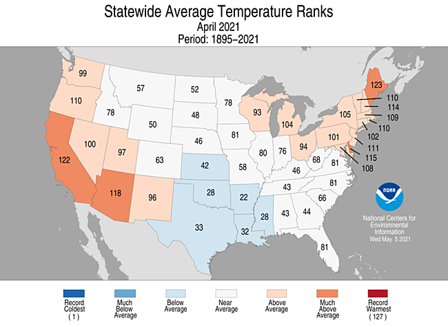
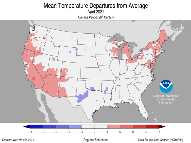
- During April, the average temperature of the contiguous U.S. was 51.9°F, 0.9°F above the 20th-century average. This ranked in the middle third of the 127-year period of record.
- Temperatures were above average across much of the West Coast, Southwest, Northeast, Great Lakes and parts of southern Texas and Florida. Maine ranked fifth warmest on record for April.
- A large portion of the southern Plains and Gulf Coast states experienced below-average temperatures, as did portions of the northern and central Rockies, northern and central Plains and the Tennessee Valley.
- The contiguous U.S. average maximum (daytime) temperature during April was 38.9°F, 0.3°F above the 20th-century average, ranking in the middle third of the historical record. Above-average conditions were observed across portions of the West, Great Lakes and Northeast, as well as south Texas and across much of Florida. Below-average maximum temperatures were observed from the Northern Rockies and Plains to the southern Plains and into the Southeast.
- The contiguous U.S. average minimum (nighttime) temperature during April was 38.9°F, 0.3°F above the 20th-century average, ranking in the middle third of the historical record. Above-average conditions were observed across portions of the West, Great Lakes and Northeast, as well as south Texas and across much of Florida. Below-average minimum temperatures were observed from the Northern Rockies and Plains to the southern Plains and into the Southeast.
- The Alaska April temperature was 23.6°F, 0.3°F above the long-term average, ranking in the middle third of the 97-year period of record. In general, the interior portions of the state were cooler than average, while the Aleutians experienced above-average temperatures for the month.
- Despite the mild average, large temperature swings were seen throughout the month as records were set for both coldest temperatures seen so late and warmest temperatures seen so early in the season across portions of Alaska.
- On April 9, Bettles set a record for its lowest April temperature on record with a report of -39°F.
- Fort Greely/Delta Junction also set a record on April 9 with the coldest sub-zero temperature on record for this location by more than a week with a high temperature report of -2°F.
- On April 17, Juneau reported a high temperature of 70°F, which was the earliest 70°F temperature on record by a week.
- On April 18, Klawock Airport reported a high temperature of 75°F, which was the highest such temperature so early in the season for all of Alaska, breaking the previous record by three days.
- Bering Sea ice cover for April was 80 percent of average and the highest for April since 2016.
- During April there were nearly 1.4 times as many warm daily records as compared with cold records. As of May 6, there were 4,617 record warm daily high (2,557) and low (2,060) temperature records and 3,236 record cold daily high (1,541) and low (1,695) temperature records.
- Based on NOAA's Residential Energy Demand Temperature Index (REDTI), the contiguous U.S. temperature-related energy demand during April was 50 percent of average and ranked 24th lowest in the 127-year period of record.
April Precipitation
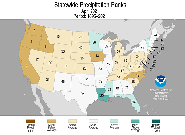
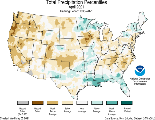
- The April precipitation total for the contiguous U.S. was 2.03 inches, 0.49 inch below average, and ranked as the 14th-driest April in the 127-year period of record. This was the driest April since 1989.
- A majority of the Lower 48 experienced below-average precipitation during April with four states across the West ranking among their 10-driest Aprils on record. Oregon ranked third driest while California ranked fifth driest on record for April. Precipitation was above average across portions of the northwest Great Lakes, New England, Midwest, southern Plains and Gulf Coast.
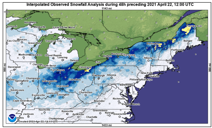
- A late-season snowstorm on April 20-22 brought record snowfall for this time of year across parts of the Ohio Valley and the Northeast. Between 5 and 7 inches of snow fell across the Cleveland area. Stations across northern New England and upstate New York also reported records. This storm snapped trees and caused power outages as well as travel problems.
- Several large hail events occurred throughout the month across the southern Plains. Hail up to the size of baseballs fell across portions of east Texas on April 8. On April 12, severe thunderstorms in central Texas produced hail up to the size of grapefruits. A widespread hail event on April 28 across Texas and Oklahoma caused significant damage to cars and homes. Hailstones as large as baseballs were associated with a line of severe weather that also sparked tornado warnings. One stone that fell in Hondo, TX, measured 6.4 inches in diameter and will be evaluated by the State Climate Extremes Committee to determine if it is the largest known hailstone on record for Texas.
- Several cities reported their driest April on record including: Lewiston, Idaho; Vancouver, Washington; and Portland, Eugene and Troutdale, Oregon.
- April is climatologically either the driest or second driest month of the year across Alaska. For April 2021, precipitation received was above average for the state as a whole. Fairbanks saw significant April snowfall with more than 16 inches reported for the month — their second-highest April total on record.
- According to the April 27 U.S. Drought Monitor report, 48.4 percent of the contiguous U.S. was in drought, up nearly 4.5 percent since the end of March. Drought conditions intensified and/or expanded across the eastern Great Lakes, Northeast, northern Rockies, northern Plains and the West Coast. Drought intensity and/or severity lessened across portions of the Upper Mississippi Valley, southern Plains and central Rockies.
- With more than 20 percent of the CONUS in extreme and exceptional drought and most of this drought occurring across the West, Southwest and northern Plains, and with the western U.S. rainy season coming to an end, concerns for competing water resources and wildfire potential are growing.
Year-to-Date Highlights
January-April Temperature
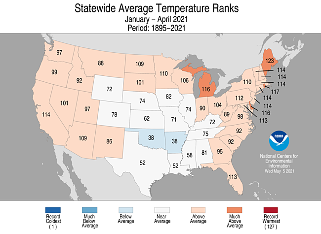
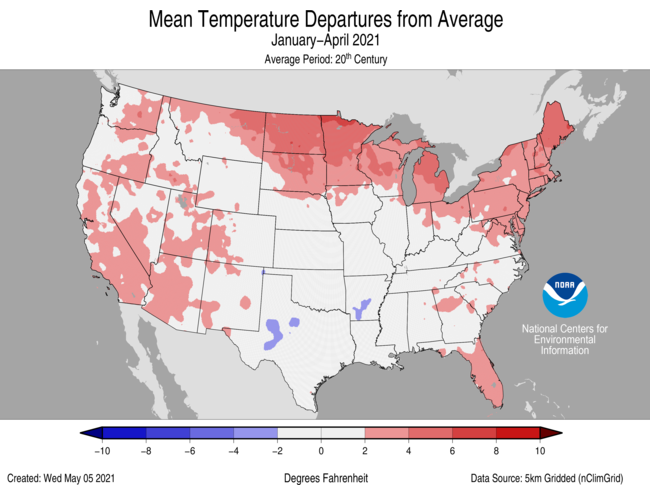
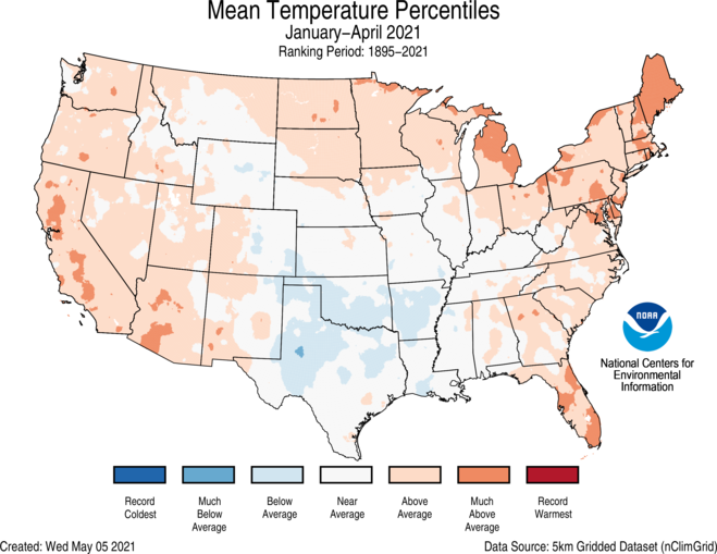
- The year-to-date (January-April) average contiguous U.S. temperature was 40.7°F, 1.6°F above average, ranking in the warmest third of the record.
- Temperatures were above average over much of the West, northern Plains, Great Lakes, Northeast and Southeast. Maine ranked fifth warmest on record for the first four months of the year. Below-average temperatures were primarily found across portions of the southern Plains.
- The Alaska January-April temperature was 11.1°F, 0.8°F above the long-term average and ranked in the middle third of the record. Temperatures were below average across portions of the Southeast Interior, Northeast Gulf and Cook Inlet regions and above average over much of the Bristol Bay and Aleutian regions.
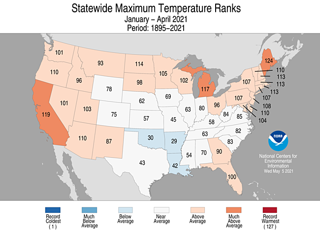
- The contiguous U.S. average maximum (daytime) temperature during January-April was 51.9°F, 1.5°F above the 20th-century average, ranking in the warmest third of the historical record. Above-average conditions blanketed much of the West, northern Plains, Great Lakes, Northeast and portions of the Southeast. Maine ranked fourth warmest for daytime temperatures in April. Temperatures were below average across parts of the middle and lower Mississippi Valley and southern Plains.
- The contiguous U.S. average minimum (nighttime) temperature during January-April was 29.4°F, 1.6°F above the 20th-century average, ranking in the warmest third of the record. Above-average temperatures blanketed an area from the Plains to the Northeast and to the Gulf Coast, as well as across portions of the West. Maine again ranked fourth warmest on record. Temperatures were below average in small pockets across the Rockies and outhern Plains.
- The Alaska January-April temperature was 11.1°F, 0.8°F above the long-term average and ranked in the middle third of the record. Temperatures were below average across portions of the Southeast Interior, Northeast Gulf and Cook Inlet regions and above average over much of the Bristol Bay and Aleutian regions.
- Based on REDTI, the contiguous U.S. temperature-related energy demand during January-April was 63 percent of average and was the 18th-lowest value on record.
January-April Precipitation
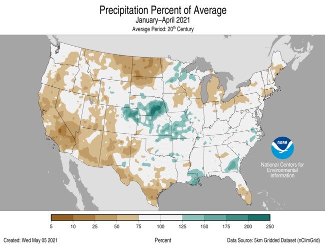
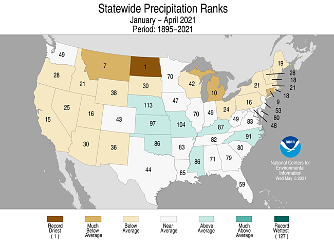
- The year-to-date national precipitation total was 8.63 inches, 0.85 inch below average, and ranked in the driest third of the January-April record.
- Below-average precipitation extended from the West Coast to the northern Plains and from the southwestern Great Lakes to the Northeast, and across southern Texas. North Dakota ranked driest for this four-month period while Montana and Connecticut ranked seventh and ninth driest, respectively. Above-average precipitation was limited to portions of the central Plains, northwest Great Lakes, central Gulf Coast and parts of the Southeast.
- With more than 82 percent of the state in extreme drought, a statewide drought disaster was declared by the governor in early April. The most recent nine months have been the driest August-April period on record for North Dakota with only 4.68 inches of precipitation reported.
- Precipitation across Alaska for the January-April period ranked in the wettest third of the 97-year record.
Extremes
-
The U.S. Climate Extremes Index (USCEI) for the year-to-date period was 19 percent below average and ranked in the middle third of the 112-year period of record. Extremes in dry PDSI were above average for the January-April period while other indicators were either near or below average for the CONUS as a whole. The USCEI is an index that tracks extremes (falling in the upper or lower 10 percent of the record) in temperature, precipitation and drought across the contiguous United States.
- On the regional scale, The Northeast, Southwest and West regions had CEI values that were above average. Across the Northeast, elevated extremes in both warm maximum and minimum temperatures as well as days without precipitation contributed to the elevated CEI value. For the West and Southwest, extremes in dry PDSI values were at record levels (Southwest), covering nearly the entire region or at near-record extent (West). CEI values for the Northern Rockies and Plains region were 53 percent below average during this period, ranking 18th lowest on record.
- The preliminary count of 73 tornadoes reported in April was the lowest April total since 53 tornadoes were reported in 1992 and was also nearly half of the April 1991-2010 average of 155 tornadoes.
Regional Highlights
These regional sumapries were provided by the six Regional Climate Centers and reflect conditions in their respective regions. These six regions differ spatially from the nine climatic regions of the National Centers for Environmental Information.
Northeast Region (Information provided by the Northeast Regional Climate Center)
- The Northeast had its 20th warmest April since 1895 with an average temperature of 47.6 degrees F (8.7 degrees C), which was 1.5 degrees F (0.8 degrees C) above normal. State average temperature departures ranged from 1.3 degrees F (0.7 degrees C) below normal in West Virginia, the lone colder-than-normal state, to 3.9 degrees F (2.2 degrees C) above normal in Maine. This April ranked among the 20 warmest on record for eight states: Maine, fifth warmest; Delaware and New Hampshire, 14th warmest; New Jersey, 17th warmest; Rhode Island and Vermont, 18th warmest; and Maryland and Massachusetts, 20th warmest.
- April wrapped up on the dry side of normal for the Northeast with 3.20 inches (81.28 mm) of precipitation, which was 85 percent of normal. Nine of the twelve Northeast states received below-normal precipitation, with New Jersey having its 20th driest April in 127 years of recordkeeping. Overall, precipitation ranged from 64 percent of normal in Delaware to 111 percent of normal in Vermont.
- The U.S. Drought Monitor released on April 1 showed 9 percent of the Northeast in a moderate drought and 28 percent as abnormally dry. During the month, moderate drought and abnormal dryness expanded in the region due to below-normal precipitation, low soil moisture, and reduced streamflow and groundwater levels. By month’s end, areas of moderate drought were found in northwestern Pennsylvania, western and northern New York, much of Vermont, southwestern New Hampshire, and north-central Massachusetts. Meanwhile, areas of abnormal dryness were found in parts of every Northeast state except New Jersey and Delaware. The U.S. Drought Monitor released on April 29 showed 14 percent of the Northeast in a moderate drought and 41 percent as abnormally dry. Low groundwater levels continued to concern officials in New England, with a few states asking residents to conserve water. Ipswich, Massachusetts, enacted voluntary water restrictions earlier than usual due to below-normal precipitation and low flow on the Ipswich River. Water restrictions were also implemented in Falmouth, Massachusetts, due to drought concerns. The aquifers that provide drinking water to Dover, New Hampshire, were around two feet (0.6 m) below normal. In Vermont, reduced streamflow affected recreational activities and Lake Champlain’s water level was below normal. Extra water was removed from Lake Ontario in January and February due to spring flooding concerns but below-normal precipitation and reduced snowpack over the past few months resulted in even lower water levels. Because of this, outflows on Lake Ontario were reduced, with the goal of allowing water levels to increase. Fire danger continued to be high in some locations due to dry conditions, causing some fire wardens in Vermont to not issue burn permits. Dry conditions in Vermont have already led some farmers to purchase feed for their livestock. In addition, maple syrup production in the state was expected to be reduced by 30 to 40 percent.
- Several storm systems moved through the Northeast during April. One of the more notable storms was from April 21 to 22 and produced severe thunderstorms and a mix of precipitation types in the region. The severe storms produced damaging winds and small hail in coastal areas from Maryland to New Hampshire. In addition, two tornadoes, an EF-1 in eastern New York and an EF-0 in western Connecticut, damaged buildings and trees. Meanwhile, interior portions of New England and New York saw up 9 inches (23 cm) of snow. A storm system dropped heavy rain on portions of New York and New England from April 29 to 30. The greatest amounts of 3 to 4 inches (76 to 102 mm) were reported in eastern Massachusetts. Binghamton, New York, picked up 2.46 inches (62.48 mm) of rain, making it the site’s third wettest April day on record. Wind gusts of up to 66 mph (30 m/s) knocked down trees and powerlines, particularly across coastal areas from Maryland to Massachusetts. Trees fell on houses and cars and blocked roads, causing an accident that injured three people. Downed wires left thousands of customers without power and likely contributed to a house fire that caused $100,000 in damage.
- For more information, please visit the Northeast Regional Climate Center Home Page.
Midwest Region (Information provided by the Midwest Regional Climate Center)
- Temperatures saw both extremes in April but averaged out to near-normal values for the month. Regionwide temperature was 49.0 degrees F (9.4 C) which was 0.3 degrees F (0.2 C) above normal. Statewide temperatures ranged from 2.3 degrees F (1.3 C) above normal in Michigan to 1.9 degrees F (1.1 C) below normal in Kentucky. Michigan ranked as the 24th warmest in its history (1895-2021). During the month, the region saw very warm temperatures from the 4th to the 9th and very cold temperatures from the 17th to the 23rd. During these extreme periods, hundreds of daily records were set or tied. There were more than 750 record lows and more than 850 record highs recorded in April.
- Regionwide precipitation for April in the Midwest was 2.70 inches (69 mm), which was 0.97 inches (25 mm) below normal. Precipitation totals ranged widely across the Midwest with most of the region below normal and two areas had above-normal precipitation. Northern and central Minnesota, northern Wisconsin, and Upper Michigan were above normal, as were much of Missouri, western Illinois, and extreme southeastern Iowa. Parts of northern Minnesota had more than twice their normal April precipitation, while a large part of Iowa, and tiny portions of Minnesota and Wisconsin had less than 25 percent of normal. Other areas in Iowa, Minnesota, Wisconsin, Illinois, Michigan, and Kentucky had less than half of their normal precipitation for the month. Iowa ranked as the 13th driest in its history back to 1895. Decorah, Iowa (120 years of data) set a new monthly precipitation record with just 0.56 inches (14 mm) breaking the 1959 record value of 0.68 inches (17 mm). Waterloo, Iowa (127 years) ranked 2nd driest, Mason City, Iowa (120 years) ranked 4th driest, and Chicago, Illinois (151 years) ranked 6th driest in their respective histories.
- A very late (April 19th to 21st) snow for the southern half of the Midwest brought well above-normal April snow totals. Most of the southern half of the region received 1 to 5 inches (3 to 13 cm) which was two or more times their normal monthly snowfall. The northern half of the region had less than normal snowfall in April, with large areas receiving less than an inch (3 cm) of snow, or no snow at all. About 200 daily snowfall records were set or tied in April, mostly in the southern half of the region.
- Drier than normal conditions in April led to an expansion of drought in the Upper Midwest. The month began with about 11 percent of the region in moderate drought, just over 1 percent in severe drought and about a quarter of a percent in extreme drought. By the end of the month the moderate drought had expanded to about 20 percent of the region, with severe drought holding relatively steady at 1 percent and the extreme drought in northwestern Iowa gone. A large part of the increase in moderate drought was in Michigan where nearly all of Lower Michigan was included.
- Reports of severe weather across the Midwest were minimal. In April, 19 days had no reports of severe weather and the busiest day was the 7th with just 34 reports. For the entire month across nine states there were fewer than 150 reports of severe weather. This total count of reports was less than 15 percent of the number of reports in April of 2020. Despite the limited number of reports, all nine Midwest states did have severe weather reports. Tornado reports (9 total) were spread across three days and four states. Iowa had tornado reports on the 7th, Michigan on the 10th, and Illinois and Missouri on 28th. Most of the large hail reports were in Minnesota on the 5th, Kentucky on the 8th, and Missouri on the 9th. Damaging thunderstorm wind reports were mostly in Illinois and Missouri on the 7th, and then again on the 28th and 29th.
- For further details on the weather and climate events in the Midwest, see the weekly and monthly reports at the Midwest Climate Watch page.
Southeast Region (Information provided by the Southeast Regional Climate Center)
- Temperatures were near average across much of the Southeast and Puerto Rico for the month of April, with very few extremes observed. Monthly mean temperatures were within 2 degrees F (1.1 degrees C) of normal in more than 80 percent of the 177 long-term (i.e., period of record equaling or exceeding 50 years) stations across the region. There were only three long-term stations that tied or ranked within the top 10 warmest or coldest values, including Covington, VA (1960-2021; 4th coldest April), Grundy, VA (1960-2021; 7th coldest April), and Bamberg, SC (1951-2021; T-9th coldest April). Daily maximum temperatures ranged from 4.2 degrees F (2.3 degrees C) above normal in Punta Gorda, FL (1965-2021) to 3 degrees F (1.7 degrees C) below normal in Marion, NC (1893-2021). Likewise, daily temperature minimums ranged from 3.4 degrees F (1.9 degrees C) above average in Melbourne, FL (1937-2021) to 4.9 degrees F (2.7 degrees C) below average in Celo, NC (1948-2021). The warmest weather of the month occurred on the 28th -30th, as the circulation around the Bermuda High, situated off the Atlantic coast, transported warm, humid air over much of the Southeast region and suppressed nighttime cooling. Daytime maximum temperatures reached or exceeded 85 degrees F (29 degrees C) across much of the region, with some stations in Virginia almost reaching 90 degrees F (32 degrees C). Indeed, Norfolk, VA (1871-2021) had a daily maximum temperature of 89 degrees F (32 degrees C), and Richmond, VA (1871-2021) had a daily maximum temperature of 88 degrees F (31 degrees C). Nighttime minimum temperatures stayed above 60 degrees (16 degrees C) in many locations. Roanoke, VA (1912-2021) had a minimum temperature of 65 degrees F (18 degrees C), which set a new high daily minimum temperature record. In contrast, the coldest weather of the month occurred on April 2nd – 3rd, as a continental high-pressure system ushered in cold, dry air from the northwest. Daily minimum temperatures fell below 32 degrees F (0 degrees C) across portions of every state north of Florida, with a few mountain locations dropping into the single digits F (-17 to -13 degrees C). Indeed, Macon, GA (1892-2021) had a daily minimum temperature of 30 degrees F (-1.1 degrees C), which was the 3rd coldest monthly minimum observed, and Mt. Mitchell, NC (1925-2021) recorded a daily minimum of 6 degrees F (-14 degrees C). A late season freeze occurred on April 22nd -23rd, with numerous stations in all states but Florida reporting daily minimum temperatures below 32 degrees F (0 degrees C). Rome, GA (1893-2021) and Raleigh, NC (1887-2021) both had a daily minimum temperature of 31 degrees F (-0.6 degrees C), setting a daily minimum temperature record. Many growers have reported total losses of blackberries, apples, and peaches due to the late season freeze.
- Precipitation varied across the Southeast region during April. The driest locations were found across South Carolina, North Carolina, southern Virginia, and eastern Puerto Rico, where precipitation totals were 70 to less than 25 percent of normal. Florence, SC (1948-2021) only received 0.15 inches (3.81 mm) of precipitation for the month, making this the driest April on record. In contrast, the wettest locations were found across southern Alabama, southern Georgia, Florida, and western Puerto Rico, where precipitation totals were 150 to more than 300 percent of normal. Alma, GA (1948-2021; 2nd wettest) reported 7.99 inches (203 mm) of rainfall for the month, over 5 inches (127 mm) above normal. On the 24th, a line of thunderstorms produced heavy rainfall across Georgia, with 24-hour precipitation totals exceeding 6 inches (152 mm) and numerous reports of localized flooding. Alma, GA (1948-2021) reported 7.66 inches (195 mm) of rain, making this the wettest 24-hour day ever on record. The mountains of North Carolina and Virginia reported very little snowfall for the month, with Mill Gap, VA (1976-2021) observing 0.9 inches (23 mm), the highest in the region.
- There were 440 reports of severe weather across the Southeast during April, which is 177 percent of the median monthly frequency of 248 reports during 2000-2019. There were 16 confirmed tornadoes reported for the month (6 EF-0, 8 EF-1, and 2 EF-2), 53 percent of the monthly average of 30. The strongest tornado occurred on April 10th in Laguna Beach, FL and was rated an EF-2 with winds of 125 mph (56 m/s). This tornado started as a waterspout that came ashore near Laguna Beach. It heavily damaged a convenience store and nearby home. Fortunately, there were no fatalities with this storm. Another EF-2 tornado occurred on April 24th in Coffee County, GA, with winds of 116 mph (52 m/s). This tornado caused widespread damage to several homes and trees however, no injuries or fatalities were reported. There were 164 reports of hail for the month, with the largest being softball sized (4.00 inches) in Orange Beach, AL, where significant hail damage reported to numerous vehicles in the area. There were 258 wind reports for the month, which is 177 percent of average (146 reports). Strong winds were observed with the severe weather on April 10th, including 75 mph (34 m/s) gusts in Dauphin Island, AL with reports of roof and tree damage. Strong winds were also observed across the region on April 30th, with winds gusting over 50 mph (22 m/s) in NC and VA. A Virginia public works employee was killed when a falling tree limb struck them while on the job in Harrisonburg.
- Below normal amounts of precipitation for the month of April increased abnormally dry conditions (D0) across North Carolina and South Carolina. The area of moderate drought (D1) is gone, but a few pockets of abnormally dry conditions (D0) still remain. Moderate precipitation slightly improved drought conditions across Florida, with a small pocket of moderate drought (D1) ringed by abnormally dry conditions (D0) in the southern peninsula. Drought conditions increased in Puerto Rico, with a general area of abnormally dry conditions (D0) and embedded pockets of moderate drought (D1) across the island. The Panhandle and northern parts of Florida experienced muddy field conditions due to the rains in April and need the fields to dry out in order to prepare them for planting. In the southern part of the peninsula, warm, dry weather increased the pest pressure, including whiteflies on vegetables, and wilting was noted in pastures. The late freeze in Georgia caused damage to several crops in the northern and middle parts of the state. There was notable damage to berries, vineyards, and peaches. The southern part of the state reported heavy rains and hail damage that impacted crops. Producers are in the process of assessing the frost and hail damage in Alabama. Dry conditions in the northern counties required the employment of irrigation for the first time this year. However, in the southern counties, heavy rainfall from storms caused a surplus of soil moisture and flood damage to fields. In South Carolina, the continued lack of rainfall has farmers choosing which fields to plant based on soil moisture; in addition, the planting/transplanting of tobacco has stopped because of the soil moisture deficit. Similarly, in North Carolina, soils are getting dry slowing down planting and pasture growth.
- For more information, please visit the Southeast Regional Climate Center Home Page.
High Plains Region (Information provided by the High Plains Regional Climate Center)
- Drought continued to impact over half the region this month, with relatively cool and dry conditions overall. In the west, there were slight improvements in Colorado, but drought conditions expanded by nearly 14 percent in Wyoming. Several Colorado communities were asked to voluntarily reduce their water use in anticipation of the spring and summer. Interestingly, Fort Collins had voluntary restrictions due to concerns over potential water quality issues from runoff in areas that burned in the Cameron Peak Fire last year. The winter wheat crop in Colorado also continued to be impacted, with 31 percent in poor to very poor condition at the beginning of May, according to the USDA National Agricultural Statistics Service. Several impacts have also been reported across Wyoming, particularly for ranchers who were dealing with poor pasture and range conditions. Hunting activities may also be impacted, as the Wyoming Game and Fish Department proposed to reduce pronghorn licenses this year due to a combination of the ongoing drought and spring blizzard.
- Meanwhile, drought intensified across the Northern Plains, with extreme drought (D3) expanding by about 11 percent in South Dakota and 36 percent in North Dakota. This intensification was due to a combination of mounting precipitation deficits, depleted soil moisture reserves, and below-normal streamflows. Spotty rain and snow showers merely helped to stave off additional degradations. Many impacts have been reported this month, including dry stock ponds and creeks, low feed supplies, the culling of herds, and an increase in fire danger. The Drought Hotline and hay map were reactivated in North Dakota, giving ranchers an outlet to buy/sell hay or offer help, while a series of drought webinars were planned in South Dakota in order to provide additional information for people there. Fire emergencies were also declared in both states at the start of April, as warm, dry conditions prevailed early in the month. Thousands of acres burned, including portions of the Theodore Roosevelt National Park in North Dakota.
- Temperature
- After an extremely warm March, temperatures moderated during the month of April with most locations having temperature departures near or just below normal. Widespread temperature departures of 2.0-4.0 degrees F (1.1-2.2 degrees C) below normal occurred across much of the region, with the main exception in portions of southwestern Colorado where temperatures were 2.0-4.0 degrees F (1.1-2.2 degrees C) above normal. As is usually the case, the month was not consistently warm or cool for any location, with several ups and downs over the course of the month. This led to some interesting extremes that were masked by the moderate overall departures.
- For instance, Casper, WY tied for its highest April temperature on record with 84.0 degrees F (28.9 degrees C) on the 30th. 84.0 degrees F (28.9 degrees C) was also reached on April 30, 1992 (period of record 1939-present). Just about a week and a half prior to this new record, Casper had a low temperature of 10.0 degrees F (-12.2 degrees C) and 4.4 inches (11 cm) of new snow on the 19th. These types of extremes are common in the spring in the High Plains region.
- Temperatures have had a mixed impact on the progression of spring, according to the USA National Phenology Network. As of the beginning of May, spring leaf out had occurred across the entire High Plains region, with the exception of some mountainous areas. Spring bloom, however, was confined to Kansas, southern and eastern Nebraska, and southeastern Colorado. This was early across much of Kansas, but late in Nebraska and Colorado. To track leaf out and bloom out in your area, see: https://www.usanpn.org/news/spring.
- Precipitation
- Overall, April was a dry month for the High Plains region. Large areas received less than 50 percent of normal precipitation, including much of North Dakota, western South Dakota, northern Nebraska, western and central Kansas, western and southern Colorado, and pockets of Wyoming. This caused some locations to rank among the top 10 driest Aprils on record. For example, Dodge City, KS had its 10th driest April with only 0.33 inch (8 mm), which was 18 percent of normal (period of record 1874-present). Dodge City’s driest April occurred in 1909 with 0.02 inch (1 mm).
- Looking back before April, mounting precipitation deficits have contributed to an expansion and intensification of drought conditions across much of North Dakota, northern South Dakota, and eastern Montana. Year-to-date deficits in these areas were generally in the range of 1.50-3.00 inches (38-76 mm), with water year-to-date deficits approaching 4.00-6.00 inches (102-152 mm) in some areas. This is a considerable deficit given that much of this area receives, on average, less than 20.00 inches (508 mm) of precipitation per year. As an example, year-to-date precipitation in Bismarck, ND was 1.15 inches (29 mm) at the end of April. This paltry amount was enough to rank as the 3rd driest January-April precipitation total on record (period of record 1874-present). The driest January-April time period occurred in 1926 with 1.00 inch (25 mm).
- Although the majority of the region was dry, a few areas received above-normal precipitation. Northeastern Colorado, northeastern South Dakota, southeastern North Dakota, and pockets of Wyoming received at least 130 percent of normal precipitation. This precipitation helped to alleviate, or eliminate, drought conditions in some areas. A notable storm system at the end of the month brought heavy rain, snow, and severe weather to parts of Colorado. The heaviest amounts ranged from 4.00-6.00 inches (102-152 mm) of rain out on the Plains and 6.0-12.0 inches (15-30 cm) of snow in the higher elevations. One location that received ample precipitation from this storm was Akron, which is located in northeastern Colorado. Akron received 2.81 inches (71 mm) in just one day - April 27th. This amount ranked as the highest one-day precipitation total for the month of April and 6th highest for any month. Akron’s monthly total was 3.58 inches (91 mm), which ranked as the second wettest April on record, just behind 1983 (3.94 inches / 100 mm) (period of record 1937-present).
- According to the U.S. Army Corps of Engineers, snowpack has peaked in the upper Missouri Basin. This year, the Snow Water Equivalent (SWE) above Fort Peck Reservoir peaked on March 31st at 86 percent of the normal peak, while the reach between Fort Peck and Garrison Reservoirs peaked on April 26th at 96 percent of the normal peak. As of May 2nd, the SWE for both reaches was below normal, at 78 percent of normal and 91 percent of normal, respectively. The 2021 runoff forecast for the upper Missouri Basin has been adjusted downward to 17.8 MAF as of May 1st. This is 69 percent of average. Next month’s summary will shift away from snowpack and will focus on streamflow. For more updates on snowpack, see the Water Supply section here: https://hprcc.unl.edu/tribal-dashboards/dashboard.php.
- Overall, the area experiencing drought (D1-D4) in the High Plains region remained at about 64 percent this month, according to the U.S. Drought Monitor. Although the total area was unchanged, there were several areas that had improvements or degradations over the course of the month. The largest reduction in drought conditions occurred in South Dakota, with a decrease of about 14 percent. These improvements were generally confined to eastern and southwestern areas of the state, which received above-normal precipitation. Drought intensified across the northwest, however, with an 11 percent increase in extreme drought (D3). In Wyoming, nearly the opposite occurred. Precipitation helped to improve drought conditions, particularly in the central part of the state, where D3 was reduced by about 12 percent. However, the statewide areal coverage of drought increased by nearly 14 percent due to ongoing dry conditions. North Dakota also had large changes in drought intensity, with a 36 percent increase in D3 over the course of the month. By the end of April, approximately 83 percent of the state was in D3, which was the highest amount since the U.S. Drought Monitor began. Prior to 2021, the record was about 46 percent during the 2017 Northern Plains drought (July 25, 2017). Elsewhere in the region, only minor adjustments to drought conditions were made. Abnormally dry conditions did expand across southern Kansas due to recent dryness.
- For more information, please visit the High Plains Regional Climate Center Home Page.
Southern Region (Information provided by the Southern Regional Climate Center)
- Temperatures for the month of April were below normal across much of the Southern Region. Parts of southern, southeastern, and far western Texas experienced temperatures 0 to 2 degrees F (0.00 to 1.11 degrees C) above normal, while parts of southern and far western Texas experienced temperatures 2 to 4 degrees F (1.11 to 2.22 degrees C) above normal. Conversely, parts of northern, southwestern, and southeastern Louisiana; southern, eastern, and northern Arkansas; southern, western, and eastern Mississippi; northern, eastern, western, and southwestern Oklahoma; northern, western, central, and eastern Texas; and most of Tennessee experienced temperatures 0 to 2 degrees F (0.00 to 1.11 degrees C) below normal. Parts of south-central Louisiana, northern and north-central Mississippi, northern and western Tennessee, central, western, northern, eastern, and southern Arkansas, eastern, southern, and western Oklahoma, and northern, western, central, and eastern Texas experienced temperatures 2 to 4 degrees F (1.11 to 2.22 degrees C) below normal. The statewide monthly average temperatures were as follows: Arkansas – 58.40 degrees F (14.67 degrees C), Louisiana – 64.80 degrees F (18.22 degrees C), Mississippi – 61.90 degrees F (16.61 degrees C), Oklahoma – 57.50 degrees F (14.17 degrees C), Tennessee – 56.60 degrees F (13.67 degrees C), and Texas – 63.70 degrees F (17.61 degrees C). The statewide temperature rankings for April were as follows: Arkansas (twenty-second coldest), Louisiana (thirty-second coldest), Mississippi (twenty-ninth coldest), Oklahoma (twenty-eighth coldest), Tennessee (forty-third coldest), and Texas (thirty-fourth coldest). The region as a whole experienced its twenty-ninth coldest April on record. All state rankings are based on the period spanning 1895-2021.
- Precipitation values for the month of April varied spatially across the Southern Region. Parts of eastern, central, and western Tennessee; northern Mississippi; western Oklahoma; and northern, western, southern, and southeastern Texas received 50 percent or less of normal precipitation. Parts western Oklahoma as well as northern, western, and southern Texas received 25 percent or less of normal precipitation, while parts of far western Oklahoma as well as northern, western and southern Texas received 5 percent or less of normal precipitation. In contrast, parts of northwestern and northern Arkansas, eastern and southern Oklahoma, central and southern Louisiana, southern Mississippi, and north-central and eastern Texas received 130 percent or more of normal precipitation. Parts of northwestern and northern Arkansas, southern Mississippi, central and southeastern Louisiana, eastern, southeastern, and southern Oklahoma, and north-central and eastern Texas received precipitation 150 percent or more of normal, while parts of southern Mississippi, southeastern and central Louisiana, and north-central Texas received 200 percent or more of normal precipitation. The statewide precipitation totals for the month were as follows: Arkansas – 5.36 inches (136.14 mm), Louisiana – 8.55 inches (217.17 mm), Mississippi – 6.96 inches (176.78 mm), Oklahoma – 3.38 inches (85.85 mm), Tennessee – 2.66 inches (67.56 mm), and Texas – 2.03 inches (51.56 mm). The statewide precipitation rankings for April were as follows: Arkansas (fiftieth wettest), Louisiana (eighth wettest), Mississippi (thirtieth wettest), Oklahoma (fifty-seventh wettest), Tennessee (fourteenth driest), and Texas (sixty-second driest). The region as a whole experienced its forty-fifth wettest April on record. All state rankings are based on the period spanning 1895-2021.
- Drought and Severe Weather
- At the end of April, drought conditions both improved and deteriorated across the Southern Region. Exceptional drought conditions persisted or expanded across northwestern, western, and southern Texas. Extreme drought conditions persisted or even expanded across parts of western and southern Texas, while new areas developed across parts of north-central and central Texas. Severe drought classifications persisted across western Oklahoma as well as northwestern, western, northeastern, central, and southern Texas, while new areas developed across parts of eastern Texas and southern Oklahoma. Moderate drought classifications expanded or developed across parts of central Texas and southern Oklahoma. However, the moderate drought conditions in northern Louisiana and parts of eastern Texas were eliminated. There was a decrease in the total area experiencing abnormally dry conditions, as abnormally dry conditions were eliminated across parts of central Mississippi, northern Louisiana, and eastern Texas. However, abnormally dry conditions developed across parts of west-central Texas as well as western and southwestern Oklahoma.
- In April, there were approximately 558 severe weather reports across Arkansas, Louisiana, Mississippi, Oklahoma, Tennessee, and Texas. There were 38 tornado reports, 295 hail reports, and 225 wind reports. Louisiana had the most tornado reports (13), Texas had the most hail reports (167), and Mississippi had the most wind reports (60). Texas had the most reports (224) while Tennessee had the fewest (22). Every state reported at least three tornadoes, while every state except for Tennessee tallied at least ten wind reports. Two states (Oklahoma and Texas) tallied more hail reports than wind reports.
- On April 7, 2021, there were thirteen tornado reports issued across Arkansas (1), Louisiana (11), and Mississippi (1), with a couple of reports in Louisiana indicating tornadoes of EF-1 strength. Additionally, there were several reports of trees and power lines blown down as well as damage to residences due to strong winds.
- On April 8, 2021, there were three tornado reports in Tennessee. Additionally, baseball sized hail was reported near College Station, Texas.
- On April 9, 2021, there were seven tornado reports across Arkansas (1), Louisiana (2), and Mississippi (4). One person was killed and seven were injured by a tornado reported near Palmetto, Louisiana. Tea cup-sized hail was reported near Henderson, Texas and Italy, Texas, while baseball sized hail was reported in Arkansas, Louisiana, Mississippi, Oklahoma, and Texas. A wind gust of 70 mph (112.65 kph) was reported near Idabel, Oklahoma, while a wind gust of 65 mph (104.61 kph) was reported near Ben Lomond, Arkansas.
- On April 10, 2021, lime-sized hail was reported near Noxapater, Mississippi.
- On April 12, 2021, tea cup-sized hail was reported near Llano, Texas, while a spotter reported hail up to grapefruit-sized near Voca, Texas.
- On April 13, 2021, a wind gust of 75 mph (120.70 kph) was reported near Grand Isle, Louisiana.
- On April 14, 2021, baseball-sized hail was reported near Anson, Texas. Additionally, a wind gust of 66 mph (106.22 kph) was reported near the mouth of the Mississippi River.
- On April 15, 2021, baseball-sized hail was reported near Loyal Valley, Texas and Bertram, Texas.
- On April 23, 2021, there were five tornado reports in north-central Texas. Hail slightly smaller than softball-sized was reported near Gilliland, Texas and Quanah, Texas. One person was injured due to a falling tree near Carnes, Mississippi, while one person was killed by a falling tree near Poplarville, Mississippi. Additionally, a wind gust of 70 mph was reported near Cameron, Louisiana.
- On April 27, 2021, there were six tornado reports across Texas (4) and Oklahoma (2). Tea cup-sized hail was reported near Truscott, Texas, while baseball sized hail was reported near Paducah, Texas and Grow, Texas. Additionally, a wind gust of 80 mph (128.75 kph) was reported near Inadale, Texas.
- On April 28, 2021, there were four tornado reports across Arkansas, Oklahoma, Tennessee, and Texas (one each). Hail larger than tea cup-sized was reported near Roanoke, Texas, while tea cup-sized hail was reported in several places across Texas and Oklahoma. Additionally, a wind gust of 75 mph (120.70 kph) was reported near Bridge Creek, Oklahoma.
Western Region (Information provided by the Western Region Climate Center)
- Dry conditions persisted throughout the western U.S. during April as a result of a weak but persistent ridge located offshore of North America. This ridge favored slightly above normal temperatures in the western half of the region, whereas the eastern portion of the region experienced slightly below normal temperatures. A few locations, notably southern New Mexico observed above normal precipitation, such as Cavern City, NM, which with records starting in 1930, observed 1.87 in. (47.5 mm) of precipitation for its fourth wettest April at 415% of normal. Dry records were much more abundant. Portland, OR received 0.39 in. (10 mm) of precipitation (14% of normal), making April 2021 its driest April since records began in 1938. With a total of 0.05 in. (1 mm; 3% of normal), Lewiston, ID also had its driest April since record keeping began in 1948. Further south along the coast, Half Moon Bay, CA recorded its second driest April since 1938 with 0.04 in. (1 mm) of precipitation (2% of normal).
- The lack of April precipitation did not improve widespread snow drought conditions throughout much of the West. While snowpack in the Pacific Northwest, the northern Front Range of the Colorado Rockies, and the Bighorn Mountains of Wyoming ended April still well above average, well below to near record low snowpack plagued the majority of the West. The lack of snowpack accumulation throughout water year 2021, as well as the generally below normal water year accumulated precipitation, resulted in many regions undergoing degradation of Drought Monitor categories by one to two categories, particularly along the coastal ranges, the northern west slope of the Sierra Nevada, and the San Joaquin Valley of CA, western MT and WY, central MT, coastal OR and WA, eastern WA, and the ID Panhandle. There were some areas of improvement, with northwestern CO and northcentral WY improving by one to two drought classes. As of this writing, approximately 95% of the western U.S. is in drought, with nearly half (47%) experiencing extreme to exceptional drought.
- Temperature anomalies during April were generally slightly colder (0-4°F; 0–2°C) in the eastern half of the West with slightly warmer temperatures (0-4°F; 0–2°C) in the western half of the West. The greatest hot temperature anomalies (4-6°F; 2–3°C) occurred in southwestern Arizona, southcentral OR, and central eastern California with the coldest anomalies found in northern NM, central WY, and along the UT/NV border (4-6°F; 2–3°C). With a mean monthly temperature of 71.8°F (22.1°C) Tucson, AZ observed its third hottest April (2.6°F; 1.4°C above average) since records started in 1895. With April records beginning in 1943, Las Vegas, NV tied its third hottest April at 70.9°F (21.6°C), which is 3.2°F (1.8°C) above normal.
- Sea surface temperatures (SST) north of the Hawaiian Islands remained 1.5–3°F (0.8-1.7°C) above normal, though colder SST anomalies associated with stronger-than-normal anticyclonic flow around the strengthening Pacific High enhanced equatorial upwelling were observed southeast of the islands. Temperatures on the Hawaiian Islands were near-normal, with many long-record stations observing mean temperatures near the long-term median. The Big Island observed hot but near normal precipitation. With a mean temperature of 74.4°F (23.6°C) Hilo, HI recorded its fourth hottest April (1.9°F (1°C) above normal; a three-way tie) since 1950. Precipitation-wise, April was near normal with 8.5 in. (217 mm) of precipitation (95% of normal).
- Alaska experienced a wilder month in terms of weather and climate extremes when compared with other western regions. During early April, many parts of the eastern and central mainland experienced the latest cold snap since records began in the mid-1900s but by mid-April, numerous locations set records for the earliest observation of various thresholds of high temperatures. Notably, Anchorage observed 10 days with a high temperature of 55°F (12°C) or higher, the most in any April since records began in 1915. Fairbanks observed its third wettest April with 1.35 in. (34 mm) of precipitation (397% of normal) since record keeping started in 1930. April 2021 was also the second snowiest on record in Fairbanks, with 16.7 in. (424 mm). Bering Sea ice extent in April was 80% of the 1981-2010 mean, which is the highest April average since 2016. Sea ice break-up north of the Bering Strait had not begun by the end of the month.
- Significant Events
- Persistent drought conditions lower fuel moistures to record levels:Chaparral ecosystems are found throughout California. Climatologically, April is when these fire-prone shrublands indicate their highest live fuel moistures. However, following back-to-back dry winters (2020 and 2021) and a 2020 warm season characterized by multiple heat waves and extreme vapor pressure deficits, live fuel moisture samples from the chamise plant were found to be at record low levels with no new growth observed. The conditions of these indicator species highlight not only a critically stressed ecosystem, but also the extreme fire hazard that will characterize the dry season of 2021 in the lower elevations. At middle-to-upper elevations, not just in California but West-wide, the well-below average snowpack is already undergoing rapid melt. This will lead to earlier drying of soils and fuels, promoting conditions favorable for wildfire ignition and spread, with standing dead fuels favoring higher intensity wildfire.