National Overview:

- Climate Highlights — October
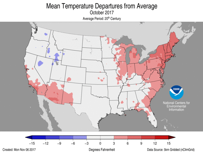 October Average Temperature Departures |
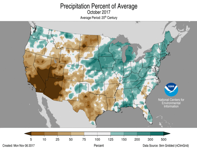 October Percent of Average Precipitation |
Temperature
- The October nationally-averaged temperature was 55.7°F, 1.6°F above the 20th century average, and ranked among the warmest third of the historical record.
- Above-average temperatures were observed for most of the eastern U.S. and parts of the Southwest. Record and near-record warmth stretched from the Great Lakes and Mid-Atlantic into New England. Connecticut, Maine, Massachusetts, New Hampshire, Rhode Island and Vermont each had their warmest October on record.
- Below-average October temperatures were observed for parts of the Northwest stretching into the northern and central Rockies and Great Basin. Some locations in the Northwest and Great Basin had a top 10 cool October.
- The contiguous U.S. average maximum (daytime) temperature during October was 68.5°F, 1.7F above the 20th century average, ranking in the warmest third of the historical record. Above-average maximum temperatures were observed across the Southwest, Midwest, Southeast, and along the East Coast. Below-average maximum temperatures were observed in parts of the Northwest.
- The contiguous U.S. average minimum (nighttime) temperature during October was 42.9°F, 1.5°F above the 20th century average, also ranking in the warmest third of the historical record. Above-average minimum temperatures spanned most locations from the Great Plains to East Coast as well as the Southwest. Below-average minimum temperatures were observed in the Northwest, northern Rockies, and Great Basin.
- During October there were 5,334 record warm daily high (1,517) and low (3,817) temperature records, which was more than two and a half times the 1,966 record cold daily high (1,060) and low (906) temperature records.
- Based on NOAA's Residential Energy Demand Temperature Index (REDTI), the contiguous U.S. temperature-related energy demand during October was 79 percent below average and ranked as the fourth lowest value in the 123-year period of record. Record and near-record temperatures in the densely populated Northeast contributed to the lower REDTI value.
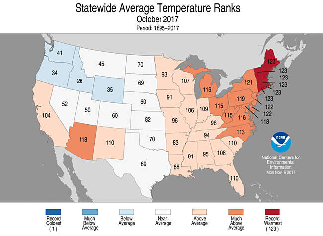
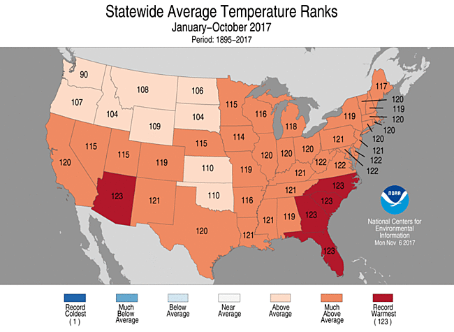
October 2017 Statewide Temperature Ranks
Precipitation
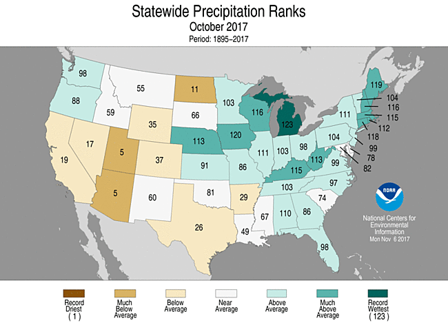
October 2017 Precipitation Ranks
- The October national precipitation total was 2.53 inches, 0.37 inch above average, and ranked among the wettest third of the historical record.
- Above-average precipitation fell across the Northwest, central Plains, Midwest and much of the East Coast. Record and near-record precipitation was observed in parts of the Midwest, Northeast and central Gulf Coast. Michigan had its wettest October on record with 244 percent of average monthly precipitation.
- Below-average precipitation was observed in the Southwest, central Rockies, northern Plains and from the southern Plains into the Lower Mississippi Valley. Arizona and Utah each tied their fifth driest October.
- According to the October 31 U.S. Drought Monitor report, 12.0 percent of the contiguous U.S. was in drought, down nearly 2.4 percent compared to the beginning of October. Drought improved across parts of the Northwest, northern Rockies to Great Plains, Midwest and Northeast. Drought conditions expanded and intensified in parts of the Southwest, southern Plains, Lower Mississippi Valley and Southeast. Outside of the contiguous U.S., drought conditions improved across parts of Hawaii.
Extremes
- Two tropical cyclones impacted the contiguous U.S. during October. Hurricane Nate made landfall near the mouth of the Mississippi River as a Category 1 Hurricane with estimated winds of 85 mph on October 8. Nate brought heavy rains to the central Gulf Coast and Southern Appalachians. Tropical Storm Philippe made landfall near Everglades National Park in Florida on October 29 with estimated sustained winds of 45 mph. The remnants of Philippe interacted with an extratropical cyclone off the East Coast, bringing heavy rain and hurricane-force winds to the Northeast.
- During the second week of October, several large and destructive wildfires devastated parts of northern California. Following a wet winter season in the region that led to a productive growing season, typical seasonal dryness during the summer and autumn dried vegetation, creating abundant wildfire fuels. A hot and windy weather pattern during October caused several wildfires to grow out of control very quickly. Thousands of homes and business were destroyed and at least 40 fatalities were reported - the deadliest week in California wildfire history, according to state officials.
- Climate Highlights — year-to-date (January-October)
 Jan-Oct Average Temperature Departures |
 Jan-Oct Percent of Average Precipitation |
Temperature
- The year-to-date U.S. average temperature was the third warmest on record at 57.5°F, 2.5°F above average. Only January-October of 2012 and 2016 were warmer.
- Every state across the contiguous U.S. had an above-average temperature for the first 10 months of the year. Thirty-nine states, stretching from coast to coast, had much-above-average temperatures for January-October. Five states in the Southwest and Southeast - Arizona, Florida, Georgia, North Carolina and South Carolina - were record warm.
- The contiguous U.S. average maximum (daytime) temperature during January-October was 69.5°F, 2.3°F above the 20th century average, ranking as the fifth highest value on record. Above-average maximum temperatures spanned the nation with the only state having a near-average maximum temperature being Washington. Much-above-average maximum temperatures were observed in the Southwest, Southern Plains, and from the Midwest to East Coast.
- The contiguous U.S. average minimum (nighttime) temperature during January-October was 45.5°F, 2.8°F above the 20th century average, ranking as the third highest value on record. Above-average minimum temperatures spanned most locations from the Great Plains to East Coast as well as the Southwest. Every state across the Lower 48 had an above-average maximum temperature for the year-to-date. Eleven states in the Southeast and Mid-Atlantic had record warm minimum temperatures.
- Based on REDTI, the contiguous U.S. temperature-related energy demand during January-October was near zero and the lowest value in the 123-year period of record.
January-October Statewide Temperature Ranks
Precipitation
- The year-to-date U.S. precipitation total was 28.93 inches, 3.57 inches above average. This was the second wettest January-October on record, with only the same period in 1998 being wetter.
- Most locations had wetter than average conditions during January-October. Much-above-average precipitation was observed across the West and parts of the southern Plains, central Gulf Coast and Great Lakes to Northeast. Nine states were much wetter than average, and Michigan was record wet. Conversely, below-average precipitation was observed across the northern Rockies to northern Plains and parts of the Southwest. North Dakota had its 10th driest
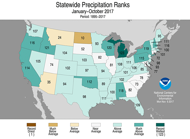
January-October Statewide Precipitation Ranks
Extremes
- The U.S. Climate Extremes Index (USCEI) for the year-to-date was the fourth highest value on record at nearly double the average. On the national scale, extremes in warm maximum and minimum temperatures, one-day precipitation totals, days with precipitation and landfalling tropical cyclones contributed to the elevated USCEI. The USCEI is an index that tracks extremes (falling in the upper or lower 10 percent of the record) in temperature, precipitation, drought and landfalling tropical cyclones across the contiguous U.S.
- On the regional scale, the CEI was much-above-average in the Northeast, Upper Midwest, Ohio Valley, Southeast, and West. In each of these regions, extremes in warm maximum and minimum temperatures were above average. In the Northeast, the component that measures days with precipitation was the fourth highest on record. In the Upper Midwest, the spatial extent of wetness was record high and days with precipitation was the sixth highest. In the Ohio Valley, one-day precipitation totals and days with precipitation were both among the ten highest values on record. In the West, one-day precipitation totals were the second highest on record.
**A comparison of the national temperature departure from average as calculated by NCDC's operational dataset (nClimDiv), the U.S. Historical Climatology Network (USHCN), and the U.S. Climate Reference Network (USCRN) is available on our National Temperature Index page.**
Regional Highlights:
These regional summaries were provided by the six Regional Climate Centers and reflect conditions in their respective regions. These six regions differ spatially from the nine climatic regions of the National Centers for Environmental Information.
- Northeast Region: (Information provided by the Northeast Regional Climate Center)
- For more information, please go to the Northeast Regional Climate Center Home Page.
- The Northeast had its second warmest October since recordkeeping began. The region's average temperature of 55.6 degrees F (13.1 degrees C) was 6.2 degrees F (3.4 degrees C) above normal. The record warmest October was 55.8 degrees F (13.2 degrees C) in 2007, only 0.2 degrees F (0.1 degrees C) warmer than October 2017. Six states had their warmest October on record: Connecticut, Maine, Massachusetts, New Hampshire, Rhode Island, and Vermont. The remaining six states ranked this October among their top ten: Delaware and New Jersey, second warmest; New York, third warmest; Pennsylvania, fifth warmest; Maryland, sixth warmest; and West Virginia, ninth warmest. State average temperature departures ranged from 4.1 degrees F (2.3 degrees C) in West Virginia to 7.9 degrees F (4.4 degrees C) in New Hampshire. In addition, eleven of the region's 35 major climate sites had a record warm October.
- The first three weeks of October were drier than normal for a large portion of the region, but back-to-back storms late in the month caused the Northeast to wrap up October on the wet side of normal. The region received 5.63 inches (143.00 mm) of precipitation, 146 percent of normal. All twelve states were wetter than normal, with nine states ranking this October among their top 20 wettest: Maine, fifth wettest; Connecticut, sixth wettest; New Hampshire, eighth wettest; Massachusetts, ninth wettest; West Virginia, 11th wettest; Rhode Island, 12th wettest; New York, 13th wettest; and Pennsylvania and Vermont, 20th wettest. Precipitation ranged from 108 percent of normal in Maryland to 172 percent of normal in Connecticut and West Virginia.
- The U.S. Drought Monitor released on October 5 showed 4 percent of the Northeast was in a moderate drought and 41 percent of the region was abnormally dry. Maine was the only state experiencing moderate drought at the start of the month, but drought expanded into the rest of New England over the next three weeks. In addition, abnormal dryness expanded across the Northeast. The U.S. Drought Monitor released on October 26 showed 12 percent of the Northeast was in a moderate drought and 51 percent of the region was abnormally dry. The dry conditions contributed to below-normal streamflow and groundwater levels in parts of the region. There were a few reports of shallow wells going dry in Maine, and two water companies, one in Connecticut and one in Pennsylvania, asked customers to reduce water use. The dry conditions also contributed to elevated fire danger in New England, with several wildfires in Maine in October. However, two storms brought heavy precipitation to the Northeast late in the month, which erased moderate drought and eased much of the abnormally dry conditions in the region. The U.S. Drought Monitor released on November 2 showed 10 percent of the region was abnormally dry.
- Low temperatures on October 8 and 9 were particularly warm, ranging from 59 degrees F (15 degrees C) to 75 degrees F (24 degrees C). At least 51 hottest minimum temperature records were set or tied at the major climate sites on those dates. Ten sites had their hottest minimum temperature for October and another 14 sites ranked their minimum temperatures among their top five hottest for October. On October 25, Caribou, ME, had a low of 64 degrees F (18 degrees C), breaking their record for warmest October minimum temperature that was set earlier in the month. In fact, Caribou's top three warmest minimum temperatures for October were all set/tied in October 2017. From October 24 to 26, New England and eastern New York received up to 8.42 inches (213.87 mm) of rain, leading to flash flooding. Numerous roadways were flooded and impassable. The system's strong winds downed trees and wires causing power outages. Another powerful storm brought heavy rain, high winds, and some snow to the Northeast from October 28 to 30. The highest rainfall total was 6.38 inches (162.05 mm) in southern Vermont. The heavy rain caused flooding across the region. Snow totals of up to 8.4 inches (21.3 cm) were reported in higher elevations of northern West Virginia and western Maryland. Wind gusts of up to 93 mph (42 m/s) downed trees and wires. News reports indicated nearly 1.5 million customers lost power in the Northeast. More than 400,000 Central Maine Power customers lost power, making it the "largest number of outages in the company's history." In New Hampshire, more than 350 roads were closed due to flooding and high winds. Flights were delayed for several hours at some major East Coast airports. In addition, hundreds of schools were closed.
- Midwest Region: (Information provided by the Midwest Regional Climate Center)
- October precipitation was above normal for most of the Midwest. Totals were 150 percent of normal in parts of all nine Midwest states with large parts of Iowa, Michigan, southern Minnesota, and northern Illinois receiving more than 200 percent of normal precipitation. Drier than normal areas with less than 75 percent of normal were in northwestern Minnesota and southeastern Missouri. Statewide numbers for October ranged from 102 percent of normal in Missouri to 200 percent of normal in Iowa and 207 percent of normal in Michigan. More than 680 daily precipitation records were set during the month with at least a couple dozen in all nine states. The first measurable snow of the season in the region fell in the northern states beginning on the 26th in Minnesota and spreading eastward with totals over 12 inches (25 cm) in the two western most counties of Upper Michigan.
- October temperatures were above normal for the first three weeks of October before dropping to below normal in the final week. Record high temperatures (475) were spread fairly evenly among the first 24 days of the month while record low temperatures (337) were largely limited to just the final four days of the month. Temperature readings of 80 degrees F (27 C) or more occurred in all nine states and readings dropped to 20 degrees F (-7 C) or less in every state except Ohio. Most of the Midwest experienced its first freezing temperature in October. A few northern stations had their first freeze in September and some station, mostly near the Great Lakes or along the Ohio River, made it through the month without dropping to freezing. For much of the Midwest the first freeze was a week or two later than the median date of the first freeze.
- Severe weather touched all nine states in October however, only Missouri, Illinois, and Michigan had more than a handful of reports. All reports of severe convective weather fell on just eight days in October (2nd, 7th, 9th, 10th, 13th-15th, and 21st). The vast majority of the reports were high winds. Tornadoes were reported on the 7th (Indiana and Wisconsin) and the 14th (Missouri and Illinois). The 7th and 14th were the busiest days for wind reports as well. The 9th and the 21st were the next busiest with just a handful of reports on the other 4 days with severe weather.
- Rains and wet fields contributed to a delayed corn harvest in the Midwest. As of the October 29th NASS Crop Progress Report, harvest progress ranged from within a couple percentage points of the 5-year average in Kentucky and Michigan to more than 25 percent behind average in Iowa, Minnesota, and Wisconsin. Soybean harvest was close to the 5-year average across the region with all nine states within plus or minus 10 percentage points of average.
- Drought eased in the Midwest overall but Missouri trended the other way. For the region as a whole, drought areas dropped from 12 percent to 7 percent while the area noted as abnormally dry or in drought dropped from about half the region to about a quarter of the region. Drought expanded in southeastern Missouri during October.
- For further details on the weather and climate events in the Midwest, see the weekly and monthly reports at the Midwest Climate Watch page.
- Southeast Region: (Information provided by the Southeast Regional Climate Center)
- Temperatures were above average across the Southeast region during October, but relatively few monthly extremes were recorded due to periods of well-below-average temperatures during the second half of the month. Only 15 of more than 175 long-term stations (i.e., period of record equaling or exceeding 50 years) across the region observed October mean temperatures that were ranked within their five warmest values on record. Eleven of these 15 stations were located in North Carolina, Virginia, and the District of Columbia. At least 65 long-term stations observed or tied their highest count of October days with a minimum temperature at or above 70 degrees F (21.1 degrees C), including Federal Point, FL (1892-2017; 19 days), Charleston, SC (1938-2017; 8 days), Charlotte, NC (1879-2017; 5 days), Athens, GA (1902-2017; 4 days), and Richmond, VA (1897-2017; 4 days). An extraordinary number of daily temperature extremes were recorded during the month. On the 1st and 10th, Tampa, FL (1890-2017) tied its second warmest daily maximum temperature on record for October, at 94 degrees F (34.4 degrees C). From the 6th through the 12th, Augusta, GA (1874-2017) observed its longest streak of 7 days during October with a maximum temperature at or above 90 degrees F (32.2 degrees C). Across the Southeast, the warmest weather of the month occurred from the 9th through the 11th, as unseasonably warm and humid air surged northward ahead of an approaching cold front. Daytime maximum temperatures ranged from 80 to 95 degrees F (26.7 to 35 degrees C) across much of the region, while nighttime minimum temperatures remained above 70 degrees F. From the 7th through the 11th, a total of 142 long-term stations across the region observed or tied their highest daily minimum temperature on record for October, including Miami, FL (1896-2017; 83 degrees F, 28.3 degrees C), Columbia, SC (1887-2017; 77 degrees F, 25 degrees C), Norfolk, VA (1874-2017; 77 degrees F), Macon, GA (1897-2017; 75 degrees F, 23.9 degrees C), Birmingham, AL (1896-2017; 75 degrees F), Raleigh, NC (1887-2017; 75 degrees F), and Washington, D.C. (1872-2017; 75 degrees F). At least 15 of these stations were found in every state, with about one third (47 of 142) located in North Carolina. It is especially outstanding that several stations observed or tied their highest minimum temperature on record for any month outside meteorological summer (i.e., June-August), including Tampa, FL (1890-2017; 81 degrees F, 27.2 degrees C), Augusta, GA (1874-2017; 78 degrees F, 25.6 degrees C), Lumberton, NC (1903-2017; 75 degrees F), and Asheville, NC (1876-2017; 71 degrees F, 21.7 degrees C). In contrast, the coldest weather of the month occurred on the 29th and 30th, as a strong frontal passage ushered in unseasonably cold air from the northwest. Daily minimum temperatures fell below 40 degrees F (4.4 degrees C) across portions of every state in the region, with much of southern Florida reaching the 50s F (10 to 15 degrees C) or lower. During this two-day period, several locations observed or tied their lowest or second lowest maximum temperature on record for October, including Highlands, NC (1893-2017; 30 degrees F, -1.1 degrees C), Jasper 1 NNW, GA (1940-2017; 37 degrees F, 2.8 degrees C), Opelika, AL (1957-2017; 49 degrees F, 9.4 degrees C), Clarks Hill 1 W, SC (1952-2017; 51 degrees F, 10.6 degrees C), and Miami, FL (1896-2017; 70 degrees F).
- Precipitation was highly variable across the Southeast region during October, with several wet extremes recorded. Unusual dryness was found in portions of north-central Florida, east-central and southeastern Georgia, central and southern South Carolina, and central North Carolina, where monthly precipitation totals were 50 to less than 25 percent of normal. In contrast, the wettest locations were found primarily across broad portions of Alabama, southern and eastern Florida, the western half of the Florida Panhandle, northern and west-central Georgia, Upstate South Carolina, western North Carolina, and southwestern Virginia. Monthly precipitation totals ranged from 150 to more than 400 percent of normal in these areas. Twenty-four long-term stations across the region observed October precipitation totals that were ranked within their five highest values on record, including Brevard, NC (1902-2017; 15.00 inches, 381 mm), Federal Point, FL (13.91 inches, 353 mm), Mobile, AL (1871-2017; 13.44 inches, 341 mm), Walhalla, SC (1896-2017; 11.00 inches, 279 mm), and Blacksburg, VA (1953-2017; 7.72 inches, 196 mm). On the 1st and 2nd, a slow-moving frontal boundary generated heavy rainfall along the eastern coast of Florida, with road flooding and stalled vehicles reported in parts of Flagler and Brevard Counties. Federal Point observed its third highest 1-day and 2-day precipitation totals for any month on record, with 7.56 and 10.95 inches (192 and 278 mm), respectively. From the 3rd through the 5th, a combination of heavy rainfall, strong easterly winds, and king tides (i.e., highest astronomical tides that occur during autumn) produced coastal flooding in southeastern Florida, with 6 to more than 12 inches of standing water reported in parts of Miami, Hollywood, and West Palm Beach. From the 7th through the 9th, Hurricane Nate produced 3 to nearly 10 inches (76.2 to nearly 254 mm) of rainfall across portions of Alabama, the western half of the Florida Panhandle, northern and west-central Georgia, Upstate South Carolina, western North Carolina, and southwestern Virginia. Multiple stations (including CoCoRaHS) in every state except Virginia recorded a 1-day precipitation total exceeding 5 inches (127 mm), with some of the greatest amounts including 9.69 inches (246 mm) at Gulf Breeze 7.2 ENE, FL, 8.10 inches (206 mm) at Jonas Ridge 1.4 S, NC, 7.22 inches (183 mm) at Dillard 3.5 NE, GA, 7.10 inches (180 mm) at Foley 4.5 SE, AL, and 7.05 inches (179 mm) at Jocassee 8 WNW, SC. In addition, Hurricane Nate generated a storm surge of 3 to more than 5 feet along the Gulf Coast from Mobile, AL to Pensacola, FL, resulting in coastal flooding and beach erosion. On the 23rd, a slow-moving complex of thunderstorms produced heavy rainfall and flash flooding across Upstate South Carolina, western North Carolina, and southwestern Virginia. Several long-term stations in these areas observed their wettest or second wettest October day on record, including Brevard, NC (7.20 inches, 183 mm), Boone, NC (1929-2017; 5.95 inches, 151 mm), Staffordsville 3 ENE, VA (1951-2017; 3.79 inches, 96.3 mm), and Anderson Regional Airport, SC (1948-2017; 3.50 inches, 88.9 mm). This was also the third and fourth wettest day for any month on record in Boone and Brevard, respectively. Over 50 apartments in Boone sustained floodwater damage, while more than a dozen people were rescued from partially submerged vehicles. From the 28th through the 29th, Tropical Storm Philippe produced 3 to more than 10 inches of rainfall across portions of east-central and southern Florida. On the 29th, measurable snowfall was observed in the higher elevations of western North Carolina and southwestern Virginia, with 1.0 and 0.5 inches (25.4 and 12.7 mm) recorded on Beech Mountain, NC and Mt. Mitchell, NC, respectively.
- There were 113 severe weather reports across the Southeast during October, which is about 240 percent of the median monthly frequency of 47 reports during 2000-2016. Approximately 80 percent (90 of 113) of the severe weather reports occurred in the Carolinas and Virginia, and nearly 75 percent (67 of 90) of these reports were recorded during a severe weather outbreak on the 23rd. On the 8th, wind gusts of 40 to more than 60 mph caused widespread downed trees and power lines across Alabama, as Hurricane Nate moved inland. Some of the highest recorded wind gusts in Alabama and the Florida Panhandle included 66 mph at Mobile Regional Airport, AL, 58 mph at Destin-Fort Walton Beach Airport, FL, 58 mph at a C-MAN station on Dauphin Island, AL, and 53 mph at Pensacola Regional Airport, FL. A total of 33 tornadoes (1 unrated, 11 EF-0s, 16 EF-1s, 5 EF-2s), with at least one in every state except Georgia, were confirmed across the region during the month, which is more than triple the median frequency of 10 tornadoes observed during October. In fact, this is the fourth highest October tornado count for the region since modern records began in 1950, trailing only 1995 (47 tornadoes), 1997 (42 tornadoes), and 2010 (37 tornadoes). On the 7th and 8th, Hurricane Nate spawned 16 tornadoes in Alabama and the Carolinas, resulting in 2 reported injuries. After touching down in Wilkes County, NC, an EF-1 tornado crossed the Blue Ridge Parkway at an elevation exceeding 3,000 feet and became the first observed tornado in Ashe County, NC since records began in 1950. From the 23rd through the 24th, another outbreak of 14 tornadoes, including three EF-2s, was produced by an extratropical low pressure system. On the 23rd, an EF-2 tornado damaged several vehicles and warehouse buildings on the northwest side of Spartanburg, SC, and one person was hospitalized with ruptured eardrums due to the rapid change in air pressure caused by the tornado. Later that day, another EF-2 tornado tracked nearly 23 miles across portions of four counties in western North Carolina. After touching down at Hickory Regional Airport, the tornado destroyed a hangar and damaged several planes that were stored inside. The tornado then widened to nearly three-fourths of a mile and downed hundreds of trees around Lake Hickory, with many falling onto houses and vehicles. On the 7th, a woman in Chiefland, FL was injured by a lightning strike while leaning on a metal fence.
- While over 97 percent of the Southeast region was drought-free at the end of October, abnormally dry (D0) conditions were observed in portions of every state except Florida. Indeed, the coverage of abnormally dry conditions across the region increased from 13 percent on October 3rd to 23 percent on October 31st. Above-average temperatures and a persistent lack of rainfall led to the development of moderate (D1) drought in portions of central North Carolina and south-central Virginia, as well as localized areas of north-central South Carolina and west-central Alabama. Predominately warm, dry weather across the Southeast was beneficial for crop harvesting and hay cutting during the month, but some pastures and crop fields were stressed by below-normal precipitation. Good yields of cotton, soybeans, and peanuts were reported across much of the region north of Florida. However, insufficient soil moisture delayed the planting of winter grains in drier areas, while livestock producers in parts of North Carolina and Virginia began feeding hay to their cattle due to poor pasture conditions. Excessive rainfall in portions of Florida kept many pastures saturated or flooded since the landfall of Hurricane Irma on September 10th. Some livestock producers had to begin an early supplemental feeding for their herds during the first week of October, as pasture conditions declined rapidly. While agricultural and livestock impacts from Hurricane Nate were relatively modest across the Southeast, some farmers in Alabama and Florida reported damage to cotton fields that had defoliated prior to the storm. In addition, the heavy rainfall produced by Nate could significantly reduce the quality of peanuts in portions of northern Florida, resulting in increased crop losses. During late October, heavy rainfall from Tropical Storm Philippe disrupted the preparation of vegetable fields in southeastern Florida and may exacerbate fungal diseases (e.g., root rot and leaf spots) that were reported by growers in Palm Beach County.
- For more information, please go to the Southeast Regional Climate Center Home Page.
- High Plains Region: (Information provided by the High Plains Regional Climate Center )
- A stark contrast in precipitation patterns existed across the High Plains during October, with wet conditions occurring early in the month in the southern and eastern parts of the region and mostly dry conditions elsewhere. Precipitation records were set on both sides of the spectrum, as there were locations that ranked among the top 10 wettest and top 10 driest Octobers on record. The wetness presented problems for producers harvesting their crops, as well as those planting winter wheat. Temperatures were largely near normal, and most of the region experienced a hard freeze in October, which ended the growing season. Drought conditions remained but continued to improve in some parts of the Northern Plains, particularly in areas of Montana that received heavy precipitation early in the month.
- While it is not uncommon for snowstorms to occur in the High Plains in October, a snowstorm in the Rockies set records for early snowfall. Havre, Montana was hit particularly hard with a snowstorm on October 2-3. The Havre Airport reported a 2-day snowfall total of 13.0 inches (33 cm), which not only was the highest 2-day total snowfall on record for October, but it was also the snowiest October on record for Havre (period of record 1961-2017). The snowstorm knocked out power to thousands of homes and damaged trees and structures in the area. Missoula, Montana received 0.1 inches (0.3 cm) of snowfall on the 2nd, which was its earliest snowfall since 1983 (period of record 1948-2017).
- While not in the High Plains region, it is worth noting that climate conditions contributed to deadly wildfires in California in October. Wildfires are a common occurrence in California during the fall, but they were made particularly worse this year due to last winter's record-setting precipitation, record-breaking summer heat, and the presence of fierce winds. The wet winter caused desert wildflowers to bloom, then the summer heat turned much of the vegetation to tinder, which provided plenty of fuel for the fires. Excessively high winds spread fires so rapidly that there was little time to evacuate, which led to the deaths of dozens of people.
- Temperatures were near normal for the month of October across the majority of the High Plains, ranging from approximately 2.0 degrees F (1.1 degrees C) below normal in Wyoming and northern Colorado to about 2.0 degrees F (1.1 degrees C) above normal across parts of North Dakota and eastern Kansas. The October temperature pattern was somewhat similar to that of September, although it was slightly warmer across central Nebraska and Kansas during September and a bit cooler in Wyoming in October.
- While October temperatures were not record-breaking throughout most of the region, it was cool enough in Laramie, Wyoming that this location tied for its 6th coolest October on record (period of record 1948-2017). On the 10th, the temperature dipped down to a chilly -2.0 degrees F (-18.9 degrees C), which was Laramie's 10th coldest October temperature on record and the 3rd earliest negative temperature (below 0.0 degrees F) ever recorded. Meanwhile, it got quite warm in southwestern Kansas on the 14th, as the temperature reached above 90.0 degrees F (32.2 degrees C) in Dodge City.
- Nearly the entire region experienced a hard freeze (defined as 28.0 degrees F (-2.2 degrees C) or lower) during October, bringing an end to the growing season. The timing of the hard freeze was fairly typical for the High Plains, although some areas of southern Kansas received a hard freeze a little earlier than expected. A sharp drop in temperature in late October in western Kansas had winter wheat growers concerned about crop injury, according to Kansas State University Agronomy. However, warm soil temperatures may have helped buffer the crop from negative effects of cold temperatures.
- With several locations ranking among the top 10 wettest or driest Octobers, the High Plains region experienced both ends of the precipitation spectrum this month. Much of the High Plains were dry, with North Dakota experiencing the most extreme dryness where precipitation was less than 10 percent of normal in some areas. This resulted in Grand Forks and Dickinson having their 3rd driest and 6th driest Octobers on record, respectively. The wettest areas included extreme southeastern South Dakota, eastern Nebraska, and eastern Kansas where October precipitation ranged from 130-300 percent of normal. The most impressive records included Salina, KS (2nd wettest), Nebraska City 2NW, NE (3rd wettest), Lincoln, NE (4th wettest), Grand Island, NE (5th wettest), and Yankton, SD (5th wettest). These locations represent the western edge of a large area extending eastward to the Great Lakes that experienced excessively wet conditions in October.
- While the dryness that occurred throughout much of the region caused few issues for agriculture, the wetness was quite problematic. For instance, producers in eastern Nebraska were concerned about soil compaction, which can occur when soils are particularly wet during harvest. According to Nebraska CropWatch, soil compaction increases runoff and can impede crop's roots for the next season. Also, harvest slowed down considerably across the Dakotas, Nebraska, and Kansas throughout September and October because of wet conditions. The USDA Weekly Weather and Crop Bulletin stated that as of the end of October, the amount of corn harvested was behind the 5-year average by as much as 20-30% in North Dakota, South Dakota, and Nebraska. As for soybeans, the harvest in South Dakota and Nebraska was far behind the 5-year average in mid-October, but drier weather in the latter half of the month allowed producers to catch up to the 5-year average.
- While row crops such as corn and soybeans are being harvested during the fall, winter wheat is being planted. This month's conditions have already negatively impacted the winter wheat crop in South Dakota, with over half the state's crop in poor to very poor condition. According to the South Dakota State Climatologist, these crop conditions were in part due to the summer drought, but poor conditions could also be attributed to intermittent rains in September that interrupted and delayed planting, causing emergence issues particularly in the western part of the state..
- Melting snow and heavy precipitation contributed to above-normal streamflows throughout parts of the High Plains region in October. For instance, snow fell in the Rockies of Colorado and Wyoming and then quickly melted with warming temperatures, causing a rise in streams. Above-normal streamflows were noted across eastern portions of the High Plains due to heavy rainfall. Several streams were running high in eastern Nebraska as a result of receiving precipitation in excess of 200 percent of normal. Meanwhile, streams in drought-stricken areas of the Dakotas continued to rise, thanks to heavy rains in late September that brought drought relief to the region. The mountain snowpack season was just getting off to a start in October, so look for this update to transition from discussing streamflow conditions to snowpack in November.
- Drought conditions continued to improve on the whole across the High Plains during October, aided by heavy rains in late September and reduced evaporative demand as the growing season wound down. According to the U.S. Drought Monitor, the area in drought (D1-D4) across the 6-state region declined from approximately 21 percent to 14 percent. The majority of the improvement occurred across the western Dakotas, particularly in North Dakota where extreme drought (D3) and exceptional drought (D4) conditions were removed. While drought continued to improve in parts of South Dakota, an area of D3 conditions in the west-central portion of the state persisted. In fact, drought conditions deteriorated slightly in the latter part of October across this area due to below-normal precipitation. Drought conditions vastly improved throughout Montana in October, with the large area of D4 in the north-central part of the state being removed and conditions improving elsewhere. Also, improvements in moderate drought (D1) were noted in Kansas where October rainfall was plentiful.
- While dryness in the fall is not of tremendous concern (and, it is even welcomed by producers harvesting their crops), it is still important to have ample soil moisture going into winter to ensure it is adequate for spring planting. This is even more critical for areas that have recently experienced drought, such as the Dakotas. Much of this region was dry in October, so precipitation is needed in this region to replenish soil moisture before the ground freezes.
- For more information, please go to the High Plains Regional Climate Center Home Page.
- Southern Region: (Information provided by the Southern Regional Climate Center)
- October temperatures were warmer than normal for most of the region. There were areas of 3 to 5 degrees F (1.7 to 2.7 degrees C) above normal in northern Tennessee, central and northern Mississippi, central Arkansas, northern, central, and southern Louisiana, western Texas, and in the panhandles of Oklahoma and Texas. Most of Oklahoma, Arkansas, Louisiana, Mississippi, and Tennessee experienced 1 to 2 degrees F (0.7 to 1.1 degrees C) above normal temperatures. Parts of west central and southern Texas experienced 1 to 2 degrees F (0.7 to 1.1 degrees C) below normal temperatures. An area of southwestern Texas experienced 3 to 5 degrees F (1.7 to 2.7 degrees C) below normal temperatures. The statewide monthly average temperatures were as follows: Arkansas — 62.80 degrees F (17.11 degrees C), Louisiana — 69.00 degrees F (20.56 degrees C), Mississippi — 66.30 degrees F (19.06 degrees C), Oklahoma — 62.00 degrees F (16.67 degrees C), Tennessee — 60.70 degrees F (15.94 degrees C), and Texas — 66.40 degrees F (19.11 degrees C). The statewide temperature rankings for October were as follows: Arkansas (forty-first warmest), Louisiana (thirty-sixth warmest), Mississippi (thirty-third warmest), Oklahoma (fifty-forth warmest), Tennessee (thirtieth warmest), and Texas (fifty-fifth warmest). All state rankings are based on the period spanning 1895-2017.
- Precipitation values for the month of October varied spatially throughout the Southern Region. Parts of western Tennessee, northern and central Mississippi, northeastern, central and southern Arkansas, northern, central, and southwestern Louisiana, south central Oklahoma, and central, southern, and western Texas received 50 percent or less of normal precipitation. There were a few areas of 5 percent or below normal precipitation in central and western Texas and the panhandle of Oklahoma. In contrast, central and eastern Tennessee, southeastern Mississippi, southeastern Louisiana, northern and central Oklahoma, and northern and extreme southern Texas received 150 percent or more of normal precipitation. There were areas of 300 percent or more of normal precipitation in the panhandle of Texas, southeastern Mississippi, and eastern Tennessee. The state-wide precipitation totals for the month were as follows: Arkansas — 1.83 inches (46.48 mm), Louisiana — 2.52 inches (64.01 mm), Mississippi — 2.88 inches (73.15 mm), Oklahoma — 3.27 inches (83.06 mm), Tennessee — 4.69 inches (119.13 mm), and Texas — 1.20 inches (30.48 mm). The state precipitation rankings for the month were as follows: Arkansas (twenty-ninth driest), Louisiana (forty-ninth driest), Mississippi (fifty-seventh wettest), Oklahoma (forty-third wettest), Tennessee (twenty-first wettest), and Texas (twenty-sixth driest). All state rankings are based on the period spanning 1895-2017.
- During October 2017, drought conditions worsened to moderate in east central Mississippi, parts of northern Louisiana, northeastern Texas, southwestern Oklahoma, and western, central, northern, and southern Arkansas. Moderate drought conditions persisted in southern Texas and a small area of north central Oklahoma. A small area of severe drought developed in southern Texas. Abnormally dry conditions expanded throughout parts of the SRCC region and now include: northern and central Mississippi, southeastern Arkansas, northern and central Louisiana, and parts of western Texas. Parts of northeastern Oklahoma and central Texas improved from abnormally dry to normal.
- Wind seemed to be the major meteorological hazard in October with roughly 103 wind events throughout the region. There were eight tornadoes during the month of October, six of which occurred on October 21. Louisiana, Arkansas, and Tennessee did not have any tornado reports in October. There were 30 hail events reported in October, 29 of which occurred on October 21.
- On October 6, 2017, there were a dozen wind reports throughout Texas and Oklahoma. A 69 mph (111.05 kph) wind gust was reported in Woods, Oklahoma.
- On October 9, 2017, a wind gust of 63 mph (101.39 mph) was reported in Muskogee, Oklahoma.
- On October 14, 2017, there was a 75 mph (120.70 kph) wind gust reported in Grady, Oklahoma.
- On October 19, 2017, there was a tornado reported in Galveston, Texas. Reported damage from the tornado included tree damage and out-building and car damage.
- On October 21, 2017, there were six tornado reports in Oklahoma with damage to residential and business buildings in Seminole, Oklahoma. Over 25 severe hail reports were received throughout Texas, Oklahoma, and Arkansas with roof damage and broken windshields reported in Jackson, Oklahoma. There were also over 50 severe wind reports between Texas, Oklahoma, and Arkansas.
- On October 22, 2017, there was a tornado reported in Pascagoula, Mississippi. The tornado passed across an industrial plant and caused significant damage to the roof and walls around the plant. There were also 19 wind events reported between Texas, Louisiana, and Mississippi.
- For more information, please go to the Southern Regional Climate Center Home Page.
- Western Region: (Information provided by the Western Region Climate Center)
- Temperatures were cooler than normal along the northern tier of the West and warmer than normal over the Southwest. A series of storms mid-month brought above normal precipitation to the Pacific Northwest, while much of the Southwest, with the exception of parts of New Mexico, remained drier than normal.
- The Pacific Northwest saw two back-to-back atmospheric river storms mid-month that caused minor to moderate flooding on some rivers. Precipitation totals from these storms resulted in above normal precipitation for the month, though were generally not record setting. On the Oregon Coast, Tillamook reported 10.61 in (269 mm) for the month, 153% of normal. Further east, Moscow, Idaho logged 3.36 in (85 mm), 155% of normal. In northern Montana, Havre observed 1.9 in (48 mm), 331% of normal and the 3rd wettest October since records began in 1961. Havre also had its snowiest October on record, with 13 in (33 cm) falling during the first three days of October. The previous record was 12 in (30 cm) in 1991. At month's end, snowpack was 150-300% of normal across the northern tier of the West. This month's precipitation supported improvement of drought conditions in the US Drought Monitor across a large portion of the Northwest. Eastern New Mexico also observed above normal precipitation, resulting mostly from a storm during the first week of the month. Tucumcari logged 2.25 in (57 mm), 153% of normal.
- Much of the Southwest observed very little precipitation, not uncommon for October. Tucson, Arizona, observed no measurable precipitation, tied with 10 other years in its 72-year record. Expansion of moderate drought conditions was observed in southwestern and eastern Arizona this month in response to lackluster rains during the North American Monsoon season, which ended September 30. San Diego, California, also reported no measurable precipitation, same as 16 other years in its 79-year record. Salt Lake City, Utah, recorded 0.18 in (5 mm), 12% of normal and the 9th driest year since records began in 1928.
- Temperatures across the Northwest were cooler than normal during October. Several low-pressure systems passed over this region during this period, bringing cool air. In east-central Oregon, temperatures averaged to 44.8 F (7.1 C), 4.8 F (2.7 C) below normal. This was the 5th coolest October since records began in 1903. Further south, Fallon, Nevada, observed an average temperature of 50.8 (10.4 C), 3.3 F (1.8 C) below normal. In southeastern Idaho, Pocatello had its 8th coolest October on record at 43.9 F (6.6 C), 3.1 F (1.7 C) below normal. Records at Pocatello began in 1939. Across the Southwest, temperatures were well above normal. Los Angeles reported its 3rd warmest October in a 141-year record at an average 74.1 F (23.4 C), 4.4 F (2.4 C) above normal. Further east, Tucson had its second warmest October at an average 77.3 F (25.2 C), 6.3 F (3.5 C) above normal. Tucson experienced 12 days with highs greater than or equal to 95 F (35 C), the second highest number of such October days on record.
- Conditions were warmer and wetter than normal across Alaska, with the exception of the Southeast, where temperatures were near normal and precipitation was generally below normal. Temperatures at Fairbanks averaged to 31.2 F (-0.4 C), 7 F (3.9 C) above normal and the 12th warmest since records began in 1929. Fairbanks also logged 2.44 in (62 mm), 294% of normal. In the Southwest, Bethel observed an average temperature of 36.7 F (2.6 C), 6.4 F (3.6 C) above normal and the 6th warmest since records began in 1923. Bethel reported 4.09 in (104 mm) precipitation, 248% of normal. On the 24-25th, a moist storm brought heavy snow to the Susitna Valley; up to 40 in (100 cm) of new snow caused major delays on the main road connection between Anchorage and Fairbanks. Further south, precipitation was variable across Hawaii, though many stations reported above normal precipitation. In West Maui, Kapalua reported 8.37 in (213 mm), 414% of normal. Much of this precipitation occurred due to thunderstorms associated with a slow moving cold front October 23-24. This event caused a nearly island-wide power outage on Maui as well as road closures. Oahu and Big Island also experienced impacts of the storm; Kona reported 2.84 in (72 mm) for the month, 211% of normal. This event did not have as much of an impact on Kauai; Lihue reported 2.8 in (71 mm), 73% of normal.
- October 8-31: Extremely destructive fires in Napa, Solano, and Sonoma County, California: During a strong -Diablo wind event (dry, northeasterly wind) in central California, several fires ignited and quickly spread. The cause of the fires is still under investigation. The Tubbs Fire became the most destructive fire in California history, destroying 5,643 structures and killing 22 people. The Nuns fire was the 6th most destructive on record, burning 1335 structures and causing two deaths. The Atlas Fire was the 10th most destructive, destroying 781 structures and killing six people. These three fires collectively burned over 140,000 acres (57,000 hectares). Smoke from these fires produced very poor air quality in the heavily populated Bay Area, creating health concerns. The fires occurred following a record hot summer and warmer than normal September and at the tail end of the dry season when fuel moisture was near record low values. At the end of the month, the Nuns and Atlas Fire were 100% contained while the Tubbs Fire was 99% contained.
- October 23-25: Heat wave in Southern California: A period of several days of well above normal temperatures affected southern California. The extreme temperatures in some cases broke daily records, but generally did not set October or all-time high temperature records. The first game of the World Series occurred during this heat wave, and fans were asked to take caution and drink lots of water. Hot temperatures and gusty winds created critical fire weather conditions. Public schools in San Diego and Long Beach closed early on the 23rd and 24th due to the excessive heat.
- For more information, please go to the Western Regional Climate Center Home Page.