National Overview:

- Climate Highlights — July
 July Average Temperature Departures |
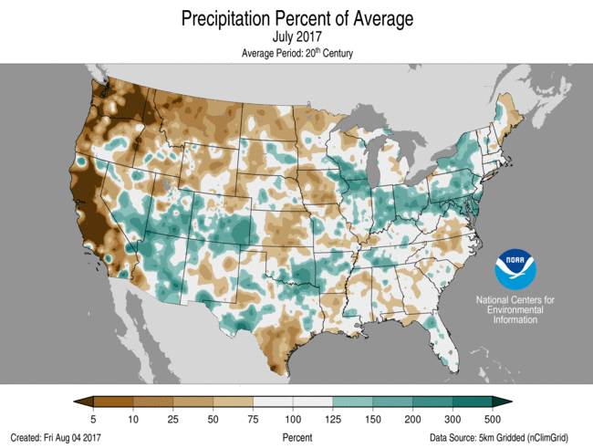 July Percent of Average Precipitation |
Temperature
- The July average temperature for the contiguous U.S. was 75.7°F, 2.1°F above the 20th century average and was the 10th warmest July in 123 years of record-keeping.
- Above-average temperatures were observed for locations from the West Coast to Rocky Mountains with several locations in the Southwest and Great Basin being record warm. Bakersfield, California; Reno, Nevada; and Salt Lake City, Utah, each had their hottest July, and hottest month, on record. Parts of the Mid-Atlantic and Southeast were also warmer than average, with Miami also observing its hottest July, and hottest month, on record.
- Near- to below-average temperatures were observed in parts of the Great Plains, South, Midwest, and Northeast. Above-average precipitation in the Midwest and Northeast was associated with suppressed daytime maximum temperatures.
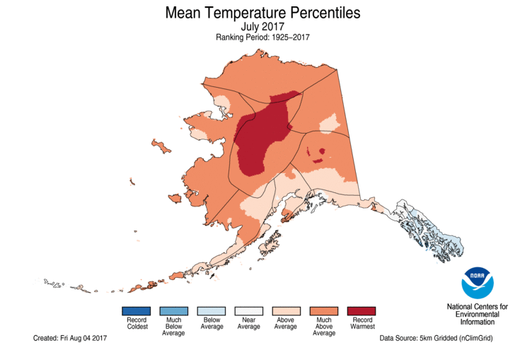
- The Alaska July temperature was 56.2°F, 3.5°F above the long-term average. This was the third warmest July on record for the state. Central and northern areas of Alaska were record warm including Barrow, Bettles, McGrath and Tanana. Many locations observed their warmest month, of any month, on record.
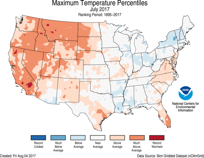
- The contiguous U.S. average maximum (daytime) temperature during July was 88.6°F, 1.9°F above the 20th century average, and tied as the 14th warmest on record. Above-average maximum temperatures were observed across the West and parts of the Great Plains and Southeast. Eight states in the West had much-above-average maximum temperatures. Below-average maximum temperatures were observed in the Midwest and Northeast and parts of the Southeast, where above-average precipitation was observed.
- The contiguous U.S. average minimum (nighttime) temperature during July was 62.8°F, 2.2°F above the 20th century average, the sixth warmest on record. Above-average minimum temperatures spanned most of the nation, with near-average conditions in the Upper Midwest and New England. Ten states in the West and six states in the Southeast and Mid-Atlantic had much-above-average minimum temperatures.
- During June there were 2,495 record warm daily high (814) and low (1,681) temperature records, which was more than three times the 763 record cold daily high (516) and low (247) temperature records.
- Based on NOAA's Residential Energy Demand Temperature Index (REDTI), the contiguous U.S. temperature-related energy demand during July was 69 percent above average and ranked as the 16th highest value in the 123-year period of record.
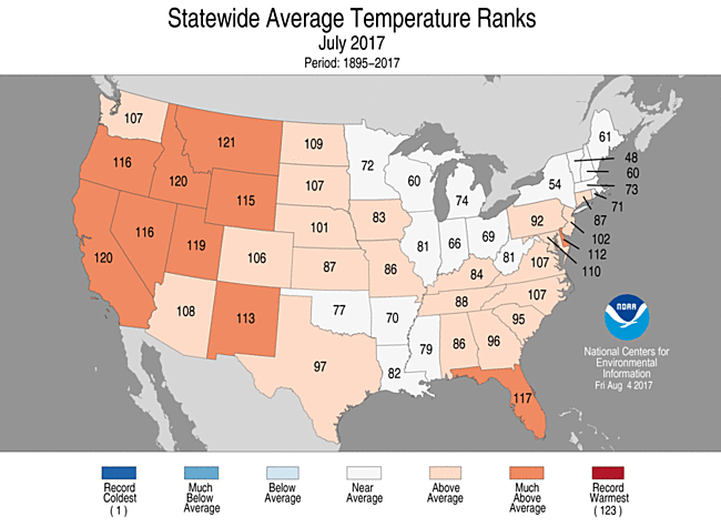
July 2017 Statewide Temperature Ranks
Precipitation

July 2017 Statewide Precipitation Ranks
- The July precipitation total was 2.74 inches, 0.04 inch below the 20th century average and was near the middle value of the 123-year period of record.
- Below-average precipitation was observed from the Northwest through the Northern Rockies and into parts of the Northern Plains and Upper Midwest. Montana had its second driest July on record with only 29 percent of average precipitation. Areas of central California were also record dry, receiving no precipitation, a common summer occurrence. The wet winter, followed by the dry summer, in the West created ideal wildfire fuels with numerous large and destructive fires burning during July. Below-average precipitation was also observed for parts of the central and southern Great Plains, Southeast and northern New England.
- Above-average precipitation was observed in the Southwest, in part due to an active monsoon season that kicked into high gear mid-month. Above-average precipitation was also observed across the Midwest and into parts of the Northeast and Mid-Atlantic with several intense one-day precipitation events causing significant flooding at numerous locations.
- According to the August 1 U.S. Drought Monitor report, 11.8 percent of the contiguous U.S. was in drought, up about 3.7 percent compared to the end of June. Drought improved across parts of the Southwest, southern High Plains and in the Washington, DC, area. Drought intensified and expanded in the Northwest, Northern Rockies and Central to Northern Plains driven by below-average precipitation and above-average temperatures. The drought and heat decimated crops in the Northern Plains. Drought and abnormally dry conditions developed in parts of the Southeast and northern Maine. Drought continued to impact parts of Hawaii and western Alaska.
- Climate Highlights — year-to-date (January-July)
 Jan-Jun Average Temperature Departures |
 Jan-Jun Percent of Average Precipitation |
Temperature
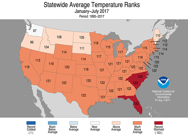
- The year-to-date (January-July) average temperature for the contiguous U.S. was 54.5°F, 3.2°F above average and second warmest on record. This was slightly warmer than the same period in 2006 and 1.2°F cooler than the record set in 2012.
- Above-average temperature spanned the nation for the first seven months of 2017 with only parts of the Northwest cooler than average. Much-above-average temperatures were observed for most locations in the Southwest and from the Rockies to the East Coast, mostly due to record and near-record warmth early in the year. Florida, North Carolina and South Carolina had their warmest January-July on record.
- The contiguous U.S. average maximum (daytime) temperature during January-July was 66.3°F, 3.0°F above the 20th century average, and tied as the fourth warmest on record. Above-average maximum temperatures were observed for most of the Lower 48, with the exception of Washington State. Thirty-one states across the Southwest, Great Plains, Midwest, Mid-Atlantic, and Southeast had much-above average maximum temperatures. South Carolina tied its record warm January-July maximum temperature. Below-average maximum temperatures were present in parts of the Northwest.
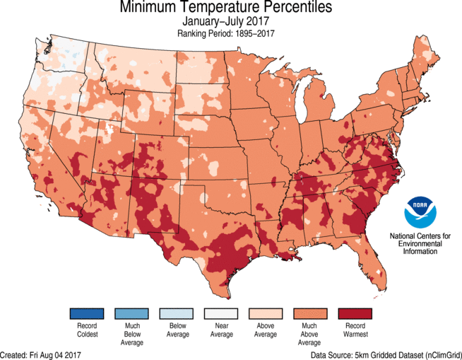
- The contiguous U.S. average minimum (nighttime) temperature during January-July was 42.7°F, 3.4°F above the 20th century average, the second warmest on record. Above-average minimum temperatures spanned most of the nation, with near-average conditions in parts of the Northwest. Forty-three states had much-above-average minimum temperatures with two states in the Southwest and eight states in the Southeast having record warm conditions.
- Based on REDTI, the contiguous U.S. temperature-related energy demand during January-July was 95 percent below average and ranked as the second lowest value in the 123-year period of record.
Jan-Jun Statewide Temperature Ranks
Precipitation
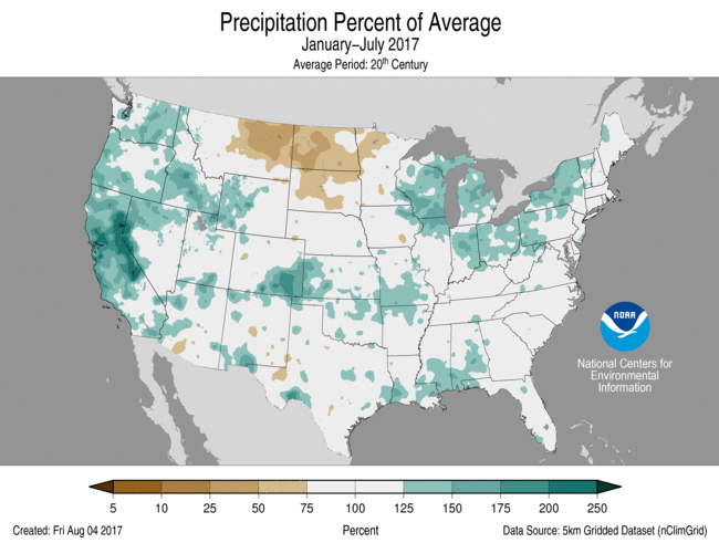
- The year-to-date precipitation total was 20.68 inches, 2.59 inches above average. This was the seventh wettest year-to-date on record and wettest since 1998.
- Above-average precipitation was observed for a large part of the contiguous U.S. with much-above-average precipitation observed for nine states across the West, and from the Great Lakes to Northeast. Wisconsin had its wettest January-July on record with 25.25 inches, 7.14 inches above average.
- Below-average precipitation was observed for the Northern Rockies and adjacent Plains. North Dakota had only 6.80 inches of precipitation, 60 percent of average. This was the third driest year-to-date for the state and the driest since 1936.

Jan-Jun Statewide Precipitation Ranks
Extremes
- The U.S. Climate Extremes Index (USCEI) for the year-to-date was the fifth highest value on record at one and a half times the average. On the national scale, extremes in warm daytime and nighttime temperatures, one-day precipitation totals, days with precipitation, and the spatial extent of wet conditions contributed to the elevated USCEI. The USCEI is an index that tracks extremes (falling in the upper or lower 10 percent of the record) in temperature, precipitation, drought and landfalling tropical cyclones across the contiguous United States.
- Regionally, the Northeast, Upper Midwest, Ohio Valley, Southeast, South, Southwest, and West each had a CEI value that was much above average. In each of these regions, extremes in warm maximum and minimum temperatures were record or near-record high. In the Northeast, the element that tracks days with precipitation was the third highest on record. In the Upper Midwest, the spatial extent of wet conditions was record high. In the Ohio Valley, one-day precipitation totals were the fifth highest on record. In the West, the spatial extent of wetness was the eighth highest on record while one-day precipitation totals ranked as the fourth highest.
Regional Highlights:
These regional summaries were provided by the six Regional Climate Centers and reflect conditions in their respective regions. These six regions differ spatially from the nine climatic regions of the National Centers for Environmental Information.
- Northeast Region: (Information provided by the Northeast Regional Climate Center)
- July averaged out to be slightly warmer than normal in the Northeast. The region's average temperature of 69.8 degrees F (21.0 degrees C) was 0.2 degrees F (0.1 degrees C) above normal. The states were split, with six wrapping up the month on the cold side of normal and six on the warm side of normal. Average temperature departures for all twelve states ranged from 0.6 degrees F (0.3 degrees C) below normal in Vermont to 1.8 degrees F (1.0 degrees C) above normal in Delaware, its 12th warmest July since 1895. In addition, Maryland had its 14th warmest July on record.
- It was the fifth wetter-than-normal month in a row for the Northeast. The region received 5.12 inches of rain (130.05 mm), 120 percent of normal, making it the 18th wettest July since recordkeeping began. Just like with average temperature, the states were split in terms of precipitation. For the drier-than-normal states, precipitation ranged from 78 percent of normal in Maine to 93 percent of normal in Vermont. For the wetter-than-normal states, precipitation ranged from 125 percent of normal in West Virginia to 205 percent of normal in Delaware. This July ranked among the top 20 wettest on record for all six of the wet states: Maryland, fifth wettest; Delaware, sixth wettest; Pennsylvania, ninth wettest; New York and West Virginia, 16th wettest; and New Jersey, 19th wettest.
- The U.S. Drought Monitor released on July 6 showed abnormally dry conditions for 3 percent of the Northeast, including portions of coastal Maine, eastern Long Island, southern Delaware, south-central Pennsylvania, and central and southern Maryland. During the month, dryness eased in Pennsylvania, Delaware, and most of Maryland but expanded in Maine and Long Island. In West Virginia, abnormal dryness was introduced mid-month but eased slightly by month's end. The U.S. Drought Monitor released on July 27 showed abnormally dry conditions for 7 percent of the Northeast.
- During July, there were multiple extreme rainfall events across the region. A particularly notable event occurred on July 23 when 4.27 inches (108.46 mm) of rain fell in one hour at the Harrisburg International Airport in Pennsylvania. This event exceeded the 100-year return period, meaning rainfall of that magnitude has a 1% chance of occurring in a given year. The daily total of 4.71 inches (119.63 mm) made it the site's fifth wettest day on record. Atlantic City, New Jersey, had its second wettest July day on record with 5.41 inches (137.41 mm) of rain on July 29. Downpours and wet conditions led to flash flooding in many parts of the region, with impacts such as numerous washed out or impassable roads, flooded basements and damaged buildings, stranded vehicles, water rescues, evacuations, and several mudslides. Agriculture was also affected. USDA crop reports from July indicated the wet conditions led to flooded and muddy fields, delayed harvest and reduced quality of hay, and stunted corn growth in wet fields. Runoff from the heavy rains contributed to high levels of bacteria along the southern New Jersey coastline, causing 15 beaches to close, as well as harmful algal blooms on several waterways including Lake Erie and Cayuga Lake, one of New York's Finger Lakes. Severe thunderstorms also caused damage in the Northeast in July. There were 14 tornadoes: five in Maine, four in Pennsylvania, three in New York, and one each in Maryland and West Virginia. All five of Maine's tornadoes touched down on July 1. For comparison, the state averages only two tornadoes a year. The National Weather Service office in Gray, Maine, issued seven tornado warnings on the 1st, which is their greatest number for any day or year on record. Maryland's tornado was an EF-2, which was the first EF-2 or stronger tornado in the state since September 2004 (according to data from NCEI's Storm Event database). The tornadoes caused structural damage to homes and businesses, as well as snapped or uprooted dozens of trees, some of which fell on and extensively damaged buildings, vehicles, and other structures. Severe storms also produced straight-line winds of up to 100 mph (45 m/s) and quarter to golfball-sized hail elsewhere in the region.
- For more information, please go to the Northeast Regional Climate Center Home Page.
- Midwest Region: (Information provided by the Midwest Regional Climate Center)
- July temperatures in the Midwest were close to normal. Temperatures were within 2 degrees F (1 C) nearly everywhere in the region. The northernmost areas were slightly below normal while the southwestern third of the region was slightly warmer than normal. Temperatures and humidity were both high in the third week of July leading to excessive heat warnings issued by some National Weather Service offices in the region.
- July precipitation in the Midwest ranged from less than 1.00 inches (25 mm) in some locations in Iowa and Minnesota to more than 6.00 inches (152 mm) for a large swath of the region extending from the southeastern tip of Minnesota, through parts of Wisconsin, Iowa, Illinois, and Kentucky, and across most of Indiana and Ohio. Totals exceeded 8.00 inches (203 mm) along the Illinois-Wisconsin border and in central Ohio. Viewed as a percentage of normal, some locations were at less than 25 percent of normal while large parts of Indiana and Ohio, along with the Illinois-Wisconsin border area, had more than 150 percent of normal. Statewide totals in both Indiana and Ohio ranked July as the 10th wettest on record (since 1895).
- Drought expanded in the Midwest in July, especially in Iowa. At the beginning of the month less than two percent of the region was in drought. This rose to nearly eight percent by the end of the month and included an area of severe drought in south central Iowa. Parts of northwestern Minnesota, east central Missouri, west central Illinois were in drought along with a big chunk of Iowa extending from the northwestern part of the state to the southeastern part and slightly into northern Missouri.
- Severe weather was reported across the entire region, including some of the drier locations in the region. Tornadoes were reported in seven states and on eight days in July. Hail and wind were much more common with only five days in the month that lacked any severe weather. Large hail, 2.00 inch (5 cm) in diameter or more, was reported at several locations in Minnesota and a few in Wisconsin.
- Crop conditions were better than some years but worse than others when compared to the past five years. 2012 was worse in nearly all locations but was not the only year topped by the current year. Most locations had a better year or two among the past five years as well. The factors causing stress on the crops varied by location with dryness and wetness both being a factor along with hail and wind damage in some locations. Some locations still had effects from late planting or replanting due to wetness in the spring.
- For further details on the weather and climate events in the Midwest, see the weekly and monthly reports at the Midwest Climate Watch page.
- Southeast Region: (Information provided by the Southeast Regional Climate Center)
- Temperatures were near average to above average across the Southeast region (including Puerto Rico and the U.S. Virgin Islands) during July, with extreme warmth occurring at several locations. At least 20 long-term (i.e., period of record equaling or exceeding 50 years) stations across the region, with 13 located in Florida, observed July mean temperatures that were ranked within their five warmest values on record. A few of these stations included Miami, FL (1896-2017; warmest on record), Williamsburg 2 N, VA (1951-2017; warmest on record), Plant City, FL (1893-2017; 2nd warmest), Guayama 2 E, PR (1914-2017; second warmest), and Pensacola, FL (1880-2017; third warmest). A much greater number of long-term stations (38) observed average minimum temperatures that were ranked within their five warmest values on record, compared to only 6 stations for average maximum temperatures. Pensacola, FL observed its highest count of 31 days during July with a minimum temperature at or above 75 degrees F (23.9 degrees C). From the 10th through the 25th, Roanoke, VA (1912-2017) recorded 16 consecutive days with a maximum temperature at or above 90 degrees F (32.2 degrees C), which is its longest July streak and ties its fourth longest streak all time. Miami, FL and Raleigh, NC (1887-2017) observed and tied their highest count of July days with a maximum temperature of at least 90 degrees F, at 30 and 25 days, respectively. Miami was exceptionally warm during July, as the city observed its warmest mean temperature for any month on record (85.7 degrees F; 29.8 degrees C). On four days during the month (1st, 3rd, 6th, and 14th), Miami tied its warmest minimum temperature for July and third warmest minimum temperature for any month on record, at 83 degrees F (28.3 degrees C). In addition, Miami observed its greatest monthly count of 19 days with a minimum temperature at or above 80 degrees F (26.7 degrees C), surpassing the previous record (August 2005) by 3 days. With the heat index (i.e., a measure of how hot it feels due to the combined effects of temperature and humidity) reaching a maximum around 110 degrees F (43.3 degrees C), Miami Beach Ocean Rescue reported 10 to 15 heat-related illnesses on the 25th. The warmest weather of the month across the Southeast occurred during two periods of excessive heat from the 13th through the 14th and the 20th through the 23rd. Daily maximum temperatures exceeded 90 degrees F across much of the region, with a few stations in the Carolinas and Virginia recording 100 degrees F (37.8 degrees C) or higher. On several days, the heat index reached a maximum of 105 to 115 degrees F (40.6 to 46.1 degrees C) across central and eastern portions of the Carolinas, as well as Tidewater Virginia. On the 14th, several stations tied their highest daily minimum temperature on record for July, including Melbourne, FL (1938-2017; 83 degrees F), Vero Beach, FL (1943-2017; 81 degrees F, 27.2 degrees C), Wilson 3 SW, NC (1917-2017; 80 degrees F), and Dunn 4 NW, NC (1963-2017; 78 degrees F, 25.6 degrees C). In contrast, the coolest weather of the month occurred on the 31st, as a continental high pressure system ushered in unseasonably cool, dry air from the north. Daily minimum temperatures fell below 65 degrees F (18.3 degrees C) as far south as southern Georgia, while much of Virginia and North Carolina recorded minimum temperatures ranging from the middle 40s F to the upper 50s F (5 to 17 degrees C).
- Precipitation was highly variable across the Southeast region during July, with a few wet and dry extremes recorded. The driest locations were found across broad portions of Upstate South Carolina, central North Carolina, and central Virginia, where monthly precipitation totals were 50 to less than 25 percent of normal. Siler City, NC (1916-2017) and Greensboro, NC (1903-2017) observed their driest and second driest July on record, with only 0.69 and 1.04 inches (17.5 and 26.4 mm) of precipitation, respectively. In contrast, the wettest locations were found across portions of the Florida Peninsula, northern Alabama, southeastern Georgia, central and coastal South Carolina, western and northeastern North Carolina, northern Virginia, and the District of Columbia. Monthly precipitation totals ranged from 150 to nearly 300 percent of normal in these areas. Lakeland Regional Airport, FL (1948-2017), Gainesville, FL (1890-2017), and Washington Dulles International Airport, VA (1962-2017) observed their wettest July on record, with 20.07, 16.70, and 8.80 inches (510, 424, and 224 mm) of precipitation, respectively. This was also the third wettest month on record for Gainesville, trailing only September 1894 (19.91 inches, 506 mm) and June 2017 (16.86 inches, 428 mm). Numerous heavy rainfall and flash flooding events occurred across the region during the month. On the 1st, the AWOS station at Robins Air Force Base, GA recorded 5.40 inches (137 mm) of rainfall in one hour, which corresponds to an average recurrence interval of approximately 1,000 years at this location. A few roads in the city of Warner Robins were closed due to flash flooding, with several reports of stalled vehicles. On the 6th and 12th, Mt. Weather, VA (1915-2017) and Miami, FL (1896-2017) observed their wettest July day on record, with 4.04 and 5.49 inches (103 and 139 mm) of precipitation, respectively. From the 14th through the 16th, heavy rainfall from a series of slow-moving thunderstorms caused flooding across southern portions of the Birmingham, AL metropolitan area. A few of the highest 3-day precipitation totals included 7.52 and 7.09 inches (191 and 180 mm) at CoCoRaHS stations in Bessemer and Pelham, respectively. Several homes were flooded in Hueytown, while a water rescue was performed for two submerged vehicles near the Birmingham Fairgrounds. On the 26th, another significant flooding event occurred south of Birmingham in the suburbs of Vestavia Hills and Hoover, as floodwater from heavy rainfall caused property damage and swept several vehicles into a raging creek. A personal weather station in Hoover recorded 3.31 inches (84.1 mm) of precipitation in approximately one hour, which only has a 2 percent probability of occurring in any given year at this location. From the 23rd through the 24th, two rounds of slow-moving thunderstorms produced heavy rainfall and flash flooding in Columbia, SC. On the 23rd, a mesonet station located at Dr. Martin Luther King Jr. Park in downtown Columbia recorded exceptional rainfall amounts of 2.99 inches (75.9 mm) in 30 minutes and 3.82 inches (97.0 mm) in 60 minutes, which correspond to an average recurrence interval of approximately 100 to 200 years at this location. Nearby, the USGS streamflow gage for Rocky Branch at Whaley Street reached its third highest crest of 12.15 feet since records began in 2007, with an increase of more than 11 feet occurring in only one hour. The streamflow crest nearly surpassed the gage height of 12.28 feet that was measured by this USGS station during the historic flood of October 2015. Capturing both rainfall events from 5:00 PM EDT on the 23rd through 5:00 PM EDT on the 24th, the University of South Carolina COOP station (1955-2017) observed its third wettest July day and seventh wettest day for any month on record, with 4.57 inches (116 mm) of precipitation. From the 28th through the 29th, heavy rainfall from a developing low pressure system caused flooding in portions of northern Virginia and Washington, D.C., with numerous reports of road closures. A CoCoRaHS station in Falls Church, VA recorded 7.72 inches (196 mm) of rainfall in the 24-hour period ending at 6:45 AM EDT on the 29th. In addition, the National Arboretum (1949-2017) in Washington, D.C. observed its wettest July day and eighth wettest day for any month on record, with 4.80 inches (122 mm) of precipitation. At approximately 8:00 AM EDT on the 31st, Tropical Storm Emily formed off the coast of Tampa Bay, FL and made landfall less than 3 hours later on Anna Maria Island, located just west of Bradenton. Plant City, FL (1895-2017) and Lakeland Regional Airport, FL observed their second wettest July day on record, with 5.36 and 4.91 inches (136 and 125 mm) of precipitation, respectively. Precipitation was above-average across much of the northern half of Puerto Rico, while below-normal amounts were found in southern portions of Puerto Rico and St. Croix in the U.S. Virgin Islands. On St. Croix, Christiansted Airport (1951-2017) observed its fifth driest July on record, with only 1.08 inches (27.4 mm) of precipitation.
- There were 795 severe weather reports across the Southeast during July, which is about 115 percent of the median monthly frequency of 687 reports during 2000-2016. At least one severe weather report was recorded on all 31 days during the month, but only five of these days (5th, 6th, 8th, 15th, and 23rd) had 50 or more reports. Strong thunderstorm winds accounted for nearly 95 percent (747 of 795) of the severe weather reports during July. Indeed, a combination of frequent thunderstorm activity and wet soils produced many downed trees across the region, with at least 48 reports of home damage. Downed trees were also responsible for 6 injuries during the month, including 5 that occurred in vehicles. Several thunderstorm wind gusts exceeding 50 mph were recorded across the region, including 66 mph at Robins Air Force Base, GA, 64 mph at Savannah-Hilton Head International Airport, GA, 63 mph at Anniston Regional Airport, AL, 58 mph at Albert Whitted Airport in St. Petersburg, FL, and 56 mph at Richmond International Airport, VA. On the 31st, wind gusts of 30 to nearly 60 mph from Tropical Storm Emily caused roof damage to a few structures across southwestern Florida and required a temporary closure of the Sunshine Skyway Bridge over Tampa Bay. Only 6 EF-0 tornadoes (4 in Florida and 2 in North Carolina) were confirmed across the region during the month, which is slightly more than half the median frequency of 10 tornadoes observed during July. On the 19th, a waterspout moved onshore at Surf City, NC and caused minor roof damage to several homes as an EF-0 tornado. On the 31st, an EF-0 tornado spawned by Tropical Storm Emily destroyed two barns and multiple greenhouses west of Bradenton, FL. Six fatalities and 21 injuries were caused by lightning strikes across the region, with 2 fatalities occurring in Alabama, Florida, and North Carolina. On the 11th, a 23-year-old Marine was struck and later killed by lightning while working on an aircraft at the New River Marine Air Corps Station in Jacksonville, NC. Another Marine was injured by the lightning strike but recovered at Camp Lejeune Naval Hospital. On the 26th, a 16-year-old boy in Dothan, AL was killed in the enclosed porch of his home, when lightning struck two nearby trees and then jumped through his body. Lightning strikes damaged at least 23 residential structures across the region, including 18 fires reported during the month.
- With the removal of a localized area of moderate (D1) drought in northeastern Georgia at the beginning of July, drought conditions (D1 and greater) were not observed across the mainland portion of the region during the remainder of the month. However, below-average precipitation caused abnormally dry (D0) conditions to develop across broad portions of North Carolina and Virginia, with below-normal streamflows also recorded in these areas. A narrow strip of moderate (D1) drought developed across the southern coast of Puerto Rico at the end of the month. Dryland crops and pastures thrived from timely rainfall and few days of extreme heat across much of the region, but detrimental impacts were reported in some areas. A persistence of heavy rainfall, especially during the first half of July, continued to delay winter wheat harvesting, hay cutting, and soybean planting across portions of Alabama and Georgia. Several wheat fields in northern Georgia were lost due to the excessive wetness, which could also prevent a subsequent planting of soybeans in those fields. High humidity and abundant rainfall resulted in fungal disease issues for several crops across the region, particularly fruit and vegetable products in Georgia and South Carolina, tobacco in parts of North Carolina and Georgia, and cotton in multiple states. Some farmers in Alabama, Georgia, and Florida were unable to spray fungicides and remove weeds in their saturated fields. A period of hot, dry weather during mid-to-late July stunted the growth of crops, hay fields, and pastures across portions of North Carolina and Virginia. Wilting of corn and soybean plants was prevalent in these areas, and some livestock fatalities in central Virginia were attributed to the unusual dryness. Plentiful rainfall and near-average temperatures during the month contributed to a bumper crop of watermelons in South Carolina, with some farmers reporting double their normal yields.
- For more information, please go to the Southeast Regional Climate Center Home Page.
- High Plains Region: (Information provided by the High Plains Regional Climate Center )
- July provided little relief to areas dealing with drought this past spring and summer, as most of the High Plains ended the month with below-normal precipitation and above-normal temperatures. The Northern Plains drought continued to spread and intensify, reaching farther across the Dakotas and southward into northern and central Nebraska. Crop stress increased in severity and became more widespread, as much of the corn and soybean crops in this region did not get adequate moisture when it was needed most. Impacts to livestock and ranching were evident during July as well. Pasture conditions worsened, and by the end of the month more than two-thirds of pastureland in the Dakotas was in poor to very poor condition. Furthermore, the quality of water in livestock ponds declined, causing livestock to become ill and die. The USDA approved additional Conservation Reserve Program (CRP) land for emergency haying and grazing to alleviate drought impacts to livestock.
- Despite the widespread dryness, above-normal precipitation occurred throughout portions of eastern Colorado, central and eastern Nebraska, and eastern South Dakota. These conditions favored the development and intensification of corn disease in some areas. For instance, warm nighttime temperatures and high relative humidity caused the spread of southern rust. According to Nebraska CropWatch, bacterial leaf streak has been a significant disease in Nebraska in 2017, and it increased in severity during July as the disease moved into the upper leaves in some corn fields. Diplodia leaf streak, a corn disease that develops and spreads in warm, wet conditions, was discovered in Nebraska for the first time.
- Heat was a common feature throughout the High Plains, resulting in several top 10 records for warmest July. Near-record-low relative humidities were reported in areas of drought, especially across portions of Montana, and contributed to the high temperatures as well as exacerbated drought conditions. High temperatures combined with high humidity to create high heat index values and dangerous conditions in the eastern part of the region.
- July temperatures ranged from near normal in the southern High Plains to 4.0-6.0 degrees F (2.2-3.3 degrees C) above normal in the northern part of the region. The greatest departures occurred in the western Dakotas where drought has been present this summer. This warmth resulted in several locations in this area experiencing July temperatures among the top 10 warmest on record: Williston, ND (2nd warmest); Dickinson, ND (tied for 2nd warmest); Bismarck, ND (5th warmest); and Rapid City, SD (7th warmest).
- A large contributor to the above-normal temperatures that occurred across parts of the High Plains was a series of heat waves that moved through the region. All six states in the High Plains region had locations that reached 100.0 degrees F (37.8 degrees C) in July. During the first part of the month, a heat wave produced especially high temperatures in Colorado. For instance, Grand Junction had five consecutive days of temperatures in the 100s from the 5th to the 9th, which has not happened since 2010.
- Another heat wave impacted the region, particularly throughout the eastern High Plains, from the 19th-22nd. High temperatures combined with high humidity prompted several National Weather Service offices to issue Heat Advisories and Excessive Heat Warnings across portions of Kansas, Nebraska, and the Dakotas. The heat was particularly impressive in Valentine, Nebraska. On the 19th, it reached an astounding 112.0 degrees F (44.4 degrees C), which was the 3rd highest temperature ever recorded at Valentine. The range of temperatures experienced in Valentine has been impressive during the past year; on December 18th, the temperature dipped down to -31.0 degrees F (-35.0 degrees C)!
- The majority of the High Plains region was dry during July, and little relief was provided to drought-stricken areas. Less than 50 percent of normal precipitation fell across North Dakota, central South Dakota, the Nebraska panhandle, and much of Wyoming and Kansas. The dryness resulted in Pierre, South Dakota having its 2nd driest July on record, while it was the 5th driest for Cheyenne, Wyoming. Meanwhile, a few areas were particularly wet during July. Monsoon conditions brought excessive precipitation to eastern Colorado, which led to Alamosa and Colorado Springs having their wettest and 3rd wettest Julys on record, respectively. Excessive precipitation across central Nebraska and eastern South Dakota helped relieve dryness in these regions.
- Despite the overall dryness, it was an active month for severe weather across the High Plains, as there were reports of high winds and large hail nearly every day of the month somewhere in the six-state region. On July 4th, the Galesburg North Dakota Automated Weather Network (NDAWN) station recorded a wind gust of 94 mph (151 km/hr) from a severe thunderstorm. According to the interim director of NDAWN, it was the highest wind speed ever recorded by an NDAWN station since 1990 when the network was established. On the 26th-27th, heavy rain caused major flooding in the Kansas City, Missouri metro area. According to the National Weather Service in Kansas City, many locations experienced more than 3 hours of rainfall rates of 1.00-2.00 inches (25-51 mm) per hour. Local streams rose quickly across Overland Park and Leawood, Kansas, resulting in multiple swift water rescues.
- Widespread dryness and above-normal temperatures contributed to the depletion of soil moisture across much of the region in July - a time when moisture is critical for row crops, such as corn and soybeans. Topsoil moisture conditions deteriorated in all six states with Kansas and North Dakota showing the largest increases in percent short to very short. According to the August 1 edition of the USDA Weekly Weather and Crop Bulletin, the percent of topsoil moisture rated short to very short in the High Plains as of July 30th was as follows: South Dakota (79%), North Dakota (73%), Nebraska (62%), Wyoming (60%), Kansas (48%), and Colorado (37%). Consequently, this combination of conditions in July led to crop stress, especially where soil moisture was inadequate.
- Over the past several months, flooding has been an issue along areas of the Wind River and its tributaries in Wyoming, as well as the North Platte River in Nebraska. Although flood waters have receded and streamflows are returning back to normal along the North Platte River, streamflows continued to be above normal in much of the Wind River Basin. In other areas of the region, heavy monsoonal precipitation across eastern Colorado and western Kansas caused much-above-normal streamflows, while persistent drought conditions in the western Dakotas caused the continuation of much-below-normal streamflows. Low streamflows in southwestern Nebraska throughout the month indicated drought development, which was reflected in the U.S. Drought Monitor's drought depiction of that region by the end of July.
- Drought continued to expand and intensify throughout the High Plains during July, as weather conditions provided little relief. According to the July 25th release of the U.S. Drought Monitor, nearly one-third of the region was experiencing drought conditions, compared to just under 20 percent at the end of June. The Northern Plains drought intensified in the Dakotas and expanded southward into northern Nebraska. Exceptional drought (D4), the highest category of intensity depicted on the U.S. Drought Monitor, was introduced to portions of western North Dakota. While Nebraska was drought-free at the end of June, drought expanded to cover approximately 40 percent of the state by the end of July. Abnormal dryness (D0) and small pockets of moderate drought (D1) slowly spread across parts of Kansas, Colorado, and Wyoming as well.
- Agricultural impacts from the drought have become widespread, particularly in the Dakotas. The U.S. spring wheat crop took a big hit this year, as the drought-stricken states of Montana, North Dakota, and South Dakota contain major wheat-growing areas. For the week ending July 29th, the USDA Weekly Weather and Crop Bulletin reported the following percentages of spring wheat in poor to very poor condition: South Dakota (75%), Montana (58%), and North Dakota (44%). Some of the destroyed crop was turned into hay for feed. Corn and soybean conditions also began to deteriorate during July. South Dakota was faring worst as soybeans and corn were rated 35% and 39% poor to very poor, respectively.
- For more information, please go to the High Plains Regional Climate Center Home Page.
- Southern Region: (Information provided by the Southern Regional Climate Center)
- Agricultural impacts from the drought have become widespread, particularly in the Dakotas. The U.S. spring wheat crop took a big hit this year, as the drought-stricken states of Montana, North Dakota, and South Dakota contain major wheat-growing areas. For the week ending July 29th, the USDA Weekly Weather and Crop Bulletin reported the following percentages of spring wheat in poor to very poor condition: South Dakota (75%), Montana (58%), and North Dakota (44%). Some of the destroyed crop was turned into hay for feed. Corn and soybean conditions also began to deteriorate during July. South Dakota was faring worst as soybeans and corn were rated 35% and 39% poor to very poor, respectively.
- Precipitation values for the month of July varied spatially across the Southern Region. Parts of southern Oklahoma, and northern and western Texas were 300% of normal precipitation. Central Tennessee, northern and western Arkansas, southern Mississippi, western and southern Oklahoma, and northern, eastern, and western Texas reported 150 - 300% of normal precipitation. In contrast, parts of northern Mississippi, southeastern Louisiana, southeastern Arkansas, northern Oklahoma, and western and southern Texas were 0 - 50% of normal precipitation. The state-wide precipitation totals for the month are as follows: Arkansas reporting 4.48 inches (113.79 mm), Louisiana reporting 4.47 inches (113.54 mm), Mississippi reporting 4.51 inches (114.55 mm), Oklahoma reporting 3.58 inches (90.93 mm), Tennessee reporting 5.15 inches (130.81 mm), and Texas reporting 2.33 inches (59.18 mm). The state precipitation rankings for the month are as follows: Arkansas (thirty-eighth wettest), Louisiana (twenty-ninth driest), Mississippi (fifth-sixth driest), Oklahoma (thirty-ninth wettest), Tennessee (thirty-sixth wettest), and Texas (sixty-first driest). All state rankings are based on the period spanning 1895-2017.
- Over the month of July 2017, drought conditions improved for some parts of the region, such as areas in eastern Texas and northeastern Mississippi. In contrast, drought conditions worsened in the panhandles of Texas and Oklahoma, central Oklahoma, and southern Texas. Currently there are areas of severe drought present in Oklahoma and Texas. At this time there are no areas of extreme or exceptional drought. Parts of Oklahoma and southern Texas became abnormally dry whereas parts of northwestern Louisiana, northeastern Mississippi, and central Texas improved from abnormally dry to normal conditions.
- On July 1, 2017, there were 65 mph (104.61 kph) wind gusts reported in Hale and Jeff Davis, Texas.
- On July 2, 2017, there was a tornado reported in Craighead, Arkansas. There were also over a dozen wind events reported throughout the region, with Osage, Oklahoma reporting 80 mph (128.75 kph) winds.
- On July 3, 2017, there was a tornado reported in Dyer, Tennessee. A macroburst wind event in Hockley, Texas caused an injury. There was an 80 mph (128.75 kph) wind gust reported in Woodward, Oklahoma.
- On July 4, 2017, there were over a dozen strong wind reports in northern Texas.
- On July 5, 2017, there were two tornado reports in Tennessee. In Humphreys, Tennessee, a tornado caused uprooted trees and structural damage.
- On July 8, 2017, there were a dozen wind reports throughout Texas and Oklahoma. In Collin, Texas there was a report of 62 mph (99.77 kph) winds.
- On July 15, 2017, there were two tornadoes reported, one in Polk, Texas and the other in Calcasieu, Louisiana. In Polk, Texas the tornado caused property damage to storage and roofs. There was a 60 mph (96.56 kph) in Cleveland, Oklahoma which bent a few street signs and caused roads to be blocked by debris.
- On July 23, 2017, there were around 20 severe wind events reported throughout the region in the states of Texas, Oklahoma, Arkansas, and Tennessee. In Coffee City, Texas, a wind event caused downed trees and at least eight downed power poles.
- On July 27, 2017, there was an 87 mph (140.1 kph) wind gust recorded in Canadian, Oklahoma snapping several power poles.
- On July 28, 2017, there was roof damage reported at a trailer facility in Johnston, Oklahoma from a thunderstorm downburst.
- For more information, please go to the Southern Regional Climate Center Home Page.
- Western Region: (Information provided by the Western Region Climate Center)
- Near record to record-breaking temperatures were observed in the Great Basin, Inland Northwest, and some parts of California this month, with near normal temperatures across the Southwest. Widespread monsoonal rains during the latter two-thirds of the month brought above normal precipitation and flooding to some areas of the Southwest.
- The Southwest Monsoon had a relatively late start this year for much of Arizona, though a series of storms beginning mid-month brought above normal, and in some cases record-breaking, precipitation to many areas of the state. Tucson, Arizona, recorded its wettest July on record and second wettest month of all-time at 6.8 in (173 mm), 302% of normal. Records for Tucson began in 1894. Other areas of the Southwest and southern Great Basin experienced above normal precipitation as well. Bodie, California reported 3.48 in (88 mm), 530% of normal and the wettest July since records began in 1895. In southeastern Colorado, La Junta observed 5.33 in (135 mm) rainfall, 291% of normal and the 3rd wettest July in a 73-year record. Above normal precipitation helped to improve drought conditions in southern Arizona and southwestern New Mexico. Some locations in the monsoon region reported below normal precipitation, which is common due to the high spatial variability of monsoonal rains. Las Vegas, Nevada, received only 0.09 in (2 mm), 23% of normal, though many locations in its vicinity were wetter than normal. Much of New Mexico saw near to slightly below normal precipitation; Albuquerque recorded only 0.85 in (22 mm) of rainfall, 57% of normal.
- Outside of the Southwest, much of the West received little to no precipitation, typical of July for areas west of the Rockies. Drier than normal conditions persisted across central and eastern Montana this month. Great Falls reported 0.08 in (2 mm), 5% of normal and the 5th driest July since records began in 1937. Glasgow recorded 0.69 in (18 mm), 39% of normal. Dry conditions coupled with above normal temperatures intensified drought conditions in Montana this month; 38% of Montana is experiencing severe to exceptional drought, all in the eastern half.
- Outside of the Southwest, much of the West received little to no precipitation, typical of July for areas west of the Rockies. Drier than normal conditions persisted across central and eastern Montana this month. Great Falls reported 0.08 in (2 mm), 5% of normal and the 5th driest July since records began in 1937. Glasgow recorded 0.69 in (18 mm), 39% of normal. Dry conditions coupled with above normal temperatures intensified drought conditions in Montana this month; 38% of Montana is experiencing severe to exceptional drought, all in the eastern half.
- Northern and Interior Alaska observed well above normal temperatures this month, while other parts of the state saw less extreme temperatures. McGrath and Tanana both reported their all-time warmest month on record at 63.7 F (17.6 C), 3.7 F (2.1 C) above normal and 65.8 F (18.8 C), 5.4 F (3 C) above normal, respectively. Records for McGrath began in 1941 and Tanana in 1902. Barrow logged its warmest July in a 117-year record at 46 F (7.8 C), 5.1 F (2.8 C) above normal. Precipitation was generally above normal in western and southeastern Alaska. Juneau reported 7.04 in (179 mm) precipitation, 153% of normal and the 10th wettest July since records began in 1936. Dry conditions in Hawaii this month prompted expansion of drought conditions, such that nearly all of Hawaii and Maui counties are in moderate or worse drought according to the US Drought Monitor. Na'alehu, on the southeastern side of the Big Island, reported 0.87 in (22 mm) this month, 24% of normal. Outside of the moderate drought area, Honolulu reported its driest July on record at 0.02 in (0.5 mm), 4% of normal. Records for Honolulu began in 1940.
- July (latter half of month): Flooding in Arizona: On July 17, a flash flood caused by monsoon thunderstorms killed 7 people at a popular swimming area east of Phoenix, Arizona. Flash flooding on July 24 stranded 17 hikers in the mountains east of Tucson; all were rescued. Severe weather also caused temporary road closures and power outages in the state.
- July (all month): Fires in the West: In the Great Basin and some parts of California, a wet winter generated fine fuels that led to increased fire hazard. Several destructive fires affected the West this month. The Detwiler Fire in the southern Sierra Nevada foothills has burned over 80,000 acres (32,000 hectares) and destroyed 63 residences. Smoke from the fire reduced air quality in the local area as well as in the western Great Basin. The fire was approximately 95% contained at the end of July. In southern California, the Whittier Fire burned over 18,000 acres (7,300 hectares) in the mountains west of Santa Barbara, destroying 16 residences and 30 outbuildings. The Wall Fire in northern California only burned 6,000 acres (2,400 hectares), but 41 residences were destroyed. The Truckee Fire, east of Wadsworth, Nevada, burned over 98,000 acres (40,000 hectares) but did not destroy any structures. The Lodgepole Complex fire in eastern Montana burned over 270,000 acres (109,000 hectares), destroyed a dozen homes, and forced ranchers to let their livestock loose.
- For more information, please go to the Western Regional Climate Center Home Page.