National Overview:

 June Average Temperature Departures |
 June Percent of Average Precipitation |
Temperature
- The June average temperature for the contiguous U.S. was 70.3°F, 1.9°F above the 20th century average, and tied as the 20th warmest June in 123 years of record keeping.
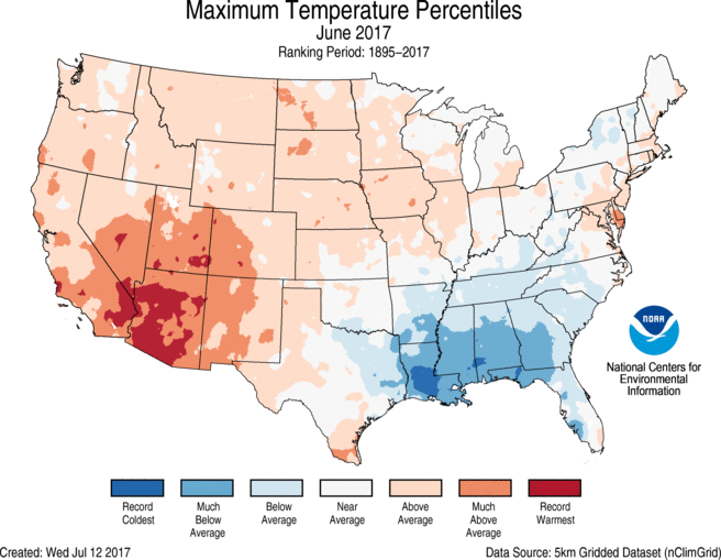
- Above-average temperatures were observed for locations from the West Coast to Rocky Mountains, with parts of the Great Plains, Great Lakes and East Coast also warmer than average. In the Southwest, much-above-average temperatures were driven by a record-breaking heat wave in mid-June. No state was record warm, but Arizona had its second warmest June on record.
- Below-average temperatures were observed in parts of the Southeast, Lower Mississippi Valley and Ohio Valley. The below-average temperatures were mostly due to much-below-average maximum temperatures, particularly along the Gulf Coast where record and near-record precipitation kept afternoon highs below average. No state was record cold.
- Alaska tied its 12th warmest June in the 94-year period of record with a statewide average temperature of 51.5°F, 2.3°F above average. Western areas of the state were warmer than average, with near- to below-average temperatures along the North Slope and in southern parts of the state. Utqia'vik (Barrow) had its first cooler-than-average month since December 2015.
- The contiguous U.S. average maximum (daytime) temperature during June was 83.3°F, 2.0°F above the 20th century average, and ranked as the 20th warmest on record. Above-average maximum temperatures were observed across the West, Great Plains, and Mid-Atlantic. Arizona observed its warmest June maximum temperature on record at 97.3°F, 6.4°F above average. This bested the previous record of 96.6°F in 2013. Below-average maximum temperatures were observed from the Deep South to the Ohio Valley. Five states along the Gulf Coast had much-cooler-than-average maximum temperatures, with Louisiana tying the second coolest June maximum temperature on record at 86.3°F, 3.8°F below average. The record coldest June maximum temperature for Louisiana was 85.8°F set in 1903.
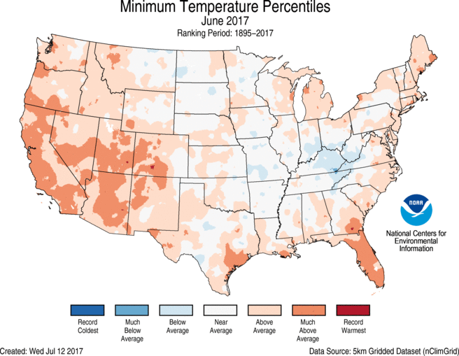
- The contiguous U.S. average minimum (nighttime) temperature during June was 57.3°F, 1.7°F above the 20th century average, the 14th warmest on record. Above-average minimum temperatures spanned the West, South, Great Lakes and East Coast. Below-average minimum temperatures were observed in the Ohio Valley and parts of the Great Plains. In the Northern Plains and Central Rockies, some locations observed freezing overnight temperatures in June which is an unusual but not unprecedented occurrence.
- During June there were 4,343 record warm daily high (1,848) and low (2,494) temperature records, which was nearly 2.5 times the 1,752 record cold daily high (974) and low (778) temperature records.
- Based on NOAA's Residential Energy Demand Temperature Index (REDTI), the contiguous U.S. temperature-related energy demand during June was 14 percent below average and ranked near the middle of the 123-year period of record. This was due to the temperature anomaly pattern of near to below-normal temperatures in the high population centers of the South and East and above-normal temperatures in the less heavily populated West and Plains.

June 2017 Statewide Temperature Ranks
Precipitation
June 2017 Statewide Precipitation Ranks
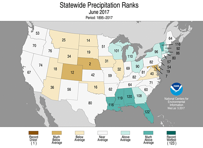
- The June precipitation total was 3.01 inches, 0.08 inch above the 20th century average, and ranked near the middle value in the 123-year period of record.
- Below-average precipitation was observed across parts of the Great Basin, Northern and Central Plains, and Mid-Atlantic. Nebraska had its second driest June and Maryland had its seventh driest. Some regions in the Southwest received no precipitation in June, which is typical of early summer. No state was record dry.
- Above-average precipitation fell across the Gulf Coast and from the Great Lakes to northern Northeast. Tropical Storm Cindy dropped heavy rain and caused significant flooding across parts the Southeast to Midwest as the storm tracked northward after making landfall near the Louisiana/Texas Coast on June 22. Alabama, Florida, Louisiana, Mississippi and Vermont were each much wetter than average. No state was record wet.
- The Alaska June average precipitation total for June was 2.04 inches, 0.30 inch below the long-term average, and ranked as the 34th driest June since 1925. Northern and south-central parts of Alaska were drier than average with above-average precipitation in southwestern and southeastern Alaska.
- According to the June 27 U.S. Drought Monitor report, 8.0 percent of the contiguous U.S. was in drought, up about 2.8 percent compared to the end of May. Drought improved across parts of the Southern Plains and Southeast. In the Southeast, drought conditions were nearly eradicated where torrential rainfall was observed over the past month, particularly along the Gulf Coast. Drought conditions expanded and worsened across the Northern to Central Plains where short-term and long-term precipitation deficits have been observed. Outside of the contiguous U.S., drought worsened for parts of Hawaii and western to central Alaska. Abnormally dry conditions improved in eastern Alaska.
- Climate Highlights — year-to-date (January-June)
 Jan-Jun Average Temperature Departures |
 Jan-Jun Percent of Average Precipitation |
Temperature
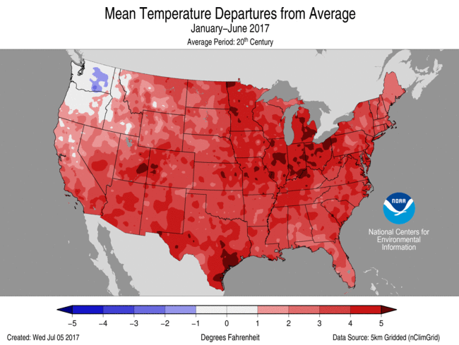
- The year-to-date average temperature for the contiguous U.S. was 50.9°F, 3.4°F above average. This was ranked as second warmest on record, slightly warmer than the same period in 2006 and 1.2°F cooler than the record set in 2012.
- Above-average temperatures spanned the nation for the first half of 2017 with only parts of the Northwest cooler than average. Much-above-average temperatures were observed for most locations from the Rockies to East Coast mostly due to record and near-record warmth early in the year. Florida, Georgia, North Carolina and South Carolina observed their warmest January-June on record.
- The Alaska January-June temperature was 22.8°F, 1.4°F above average. This ranked in the warmest third of the historical record, but was the coolest first half of a year since 2013 for the state. Northern areas of Alaska were warmer than average with some parts of southern Alaska cooler than average.
- The contiguous U.S. average maximum (daytime) temperature during January-June was 62.5°F, 3.2°F above the 20th century average, and tied 2016 as the fifth warmest on record. Above-average maximum temperatures were observed for most locations from the Rockies to East Coast with record warm maximum temperatures along the western Gulf Coast and parts of the Southeast. At the statewide level, Georgia, North Carolina, and South Carolina had record warm maximum temperatures for the first six months of 2017.
- The contiguous U.S. average minimum (nighttime) temperature during January-June was 39.3°F, 3.6°F above the 20th century average, the second warmest on record. Only January-June 2012 had warmer minimum temperatures at 39.7°F . Above-average minimum temperatures spanned much of the nation with below-average conditions in parts of the Northwest. In addition to New Mexico, ten states in the Southeast and Mid-Atlantic had a record warm January-June minimum temperature.
- Based on REDTI, the contiguous U.S. temperature-related energy demand during January-June was 88 percent below average and the second lowest value in the 123-year period of record.

Jan-Jun Statewide Temperature Ranks
Precipitation
- The year-to-date precipitation total for the contiguous U.S. was 17.86 inches, 2.55 inches above average, the sixth wettest on record and wettest since 1998.
- Above-average precipitation was observed for a large part of the contiguous U.S. with much-above-average precipitation observed for 12 states across the West, Central Plains and Great Lakes to Northeast. Idaho and Michigan each had record high precipitation totals for the first half of 2017.
- Below-average precipitation was observed for the Northern Plains. North Dakota had only 5.40 inches of precipitation, 61 percent of average. This was the fourth driest year-to-date for the state and the driest since 1936.
- The Alaska year-to-date precipitation total was 12.06 inches, 1.56 inches below average. This ranked as the 12th driest June since 1925 for the state and the driest since 2011. Below-average precipitation was observed in parts of southwestern and northwestern Alaska with above-average precipitation in western, central, and far northern Alaska.

Jan-Jun Statewide Precipitation Ranks
Extremes
- The U.S. Climate Extremes Index (USCEI) for the year-to-date was the third highest value on record at more than double the average. The USCEI is an index that tracks extremes (falling in the upper or lower 10 percent of the record) in temperature, precipitation, drought and land-falling tropical cyclones across the contiguous U.S. On the national scale, extremes in warm daytime and nighttime temperatures, one-day precipitation totals, days with precipitation, the spatial extent of wet conditions and land-falling tropical cyclones contributed to the elevated USCEI.
- On the regional scale, the Northeast, Upper Midwest, Ohio Valley, Southeast, South, and West each had record or near-record high CEI value for the year-to-date. In each of these regions, extremes in warm daytime and nighttime temperatures were above average. In the Northeast and Upper Midwest, the number of days with precipitation was much above average. In the Ohio Valley, one-day precipitation totals and days with precipitation were much above average. In the Southeast, one-day precipitation totals and the spatial extent of drought were much above average. In the South, one-day precipitation totals were much above average and in the West, the spatial extent of wetness, one-day precipitation totals and days with precipitation were all much above average.
Regional Highlights:
These regional summaries were provided by the six Regional Climate Centers and reflect conditions in their respective regions. These six regions differ spatially from the nine climatic regions of the National Centers for Environmental Information.
- Northeast Region: (Information provided by the Northeast Regional Climate Center)
- June averaged out to be warmer than normal for the Northeast. The region's average temperature of 65.5 degrees F (18.6 degrees C) was 0.3 degrees F (0.2 degrees C) above normal. Ten of the twelve states were warmer than normal, with Delaware having its 10th warmest June on record. Departures for all states ranged from 0.6 degrees F (0.3 degrees C) below normal in West Virginia to 1.6 degrees F (0.9 degrees C) above normal in Delaware. The month featured both unusually cool and unusually warm weather. At six major climate sites, high temperatures on June 6 ranged from 49 degrees F (9 degrees C) to 60 degrees F (16 degrees C), which ranked among the top five coldest high temperatures on record for summer. On June 13, LaGuardia Airport, New York, tied its all-time warmest June day on record when it reached 101 degrees F (38 degrees C). Caribou, Maine, had a low temperature of 69 degrees F (21 degrees C) on June 19, which tied its all-time warmest June low temperature on record.
- June was another wetter-than-normal month for the Northeast. The region received 4.40 inches (111.76 mm) of rain, which was 105 percent of normal. Of the twelve states, six were drier than normal and six were wetter than normal. For the dry states, rainfall ranged from 53 percent of normal in Maryland to 94 percent of normal in Rhode Island. Maryland has its seventh driest June on record, while Delaware had its 19th driest. For the wet states, precipitation ranged from 103 percent of normal in Massachusetts to 151 percent of normal in Vermont, its eighth wettest.
- The U.S. Drought Monitor released on June 1 showed small areas of abnormal dryness in Pennsylvania and Connecticut, which eased the following week. Abnormal dryness was introduced in northern West Virginia mid-month and in Pennsylvania and central Maryland a week later. Dryness eased in West Virginia by month's end, but lingered in Pennsylvania and Maryland and was introduced in coastal Maine. During the month, state drought declarations returned to normal status in Connecticut and Rhode Island.
- The U.S. Drought Monitor released on June 1 showed small areas of abnormal dryness in Pennsylvania and Connecticut, which eased the following week. Abnormal dryness was introduced in northern West Virginia mid-month and in Pennsylvania and central Maryland a week later. Dryness eased in West Virginia by month's end, but lingered in Pennsylvania and Maryland and was introduced in coastal Maine. During the month, state drought declarations returned to normal status in Connecticut and Rhode Island.
- For more information, please go to the Northeast Regional Climate Center Home Page.
- Midwest Region: (Information provided by the Midwest Regional Climate Center)
- June precipitation in the Midwest varied from more than 200 percent of normal to less than 50 percent of normal. The wettest areas were largely in Wisconsin and Michigan. A swath across Iowa and into Illinois had the driest conditions. Statewide precipitation values ranged from 69 percent of normal in Iowa to 140 percent of normal in Michigan. Michigan ranked as the 14th wettest June on record (1895-2017), just outside the wettest 10 percent.
- June temperatures averaged close to normal across the Midwest. Nearly all of the region was within 2 degrees F (1 degrees C) of normal. Warmer than normal conditions were common in the first half of the month but were offset by cooler weather later in the month. Statewide values also were close to normal with only Kentucky below normal (0.9 degrees F or 0.5 degrees C) and Iowa warmest at 1.6 degrees F (0.9 degrees C) above normal.
- Severe weather was reported in the Midwest on all but five days in June (6th-8th and 25th-26th). Two particularly busy periods for severe weather were during the middle of the month and again in the last few days of June. Tornadoes were reported on nine days and in seven states with many reports in Wisconsin on the 14th and in Iowa on the 28th. Minnesota also had numerous tornado reports during June.
- Corn and soybean crops in the region were rated as good or excellent for over half of each crop in eight of the nine Midwestern states. Indiana came in just below half of each crop being rated as such. Crops rated as fair accounted for 10 to 35 percent and less than 20 percent were rated poor or very poor.
- After a drought-free May in the Midwest, some areas of drought developed in June. The US Drought Monitor introduced areas of moderate drought in Minnesota, Iowa, and Missouri. As of the June 27th release of the US Drought Monitor, just under 2 percent of the Midwest was designated in drought.
- Snow totals in the Midwest were mostly below average for the July 2016 to June 2017 snow season. Just a few areas, including northwestern Minnesota and a narrow swath from north central Iowa to northeastern Wisconsin, were slightly above normal. The southern half of the region had totals that failed to reach 50 percent of normal with seasonal totals not even reaching 10 percent of normal in the southern extent of the Midwest.
- For further details on the weather and climate events in the Midwest, see the weekly and monthly reports at the Midwest Climate Watch page.
- Southeast Region: (Information provided by the Southeast Regional Climate Center)
- Temperatures were near average to below average across much of the Southeast region during June, but above-average temperatures occurred in parts of the Florida Peninsula, coastal North Carolina, and the eastern half of Virginia. Only eight long-term (i.e., period of record equaling or exceeding 50 years) stations across the region observed June mean temperatures that were ranked within their five warmest or coolest values on record. However, well-below-average maximum temperatures and well-above-average minimum temperatures were recorded in portions of the region. Persistent cloud cover and rainfall during the month suppressed daytime temperatures in Alabama, the western half of Georgia, and the Florida Panhandle. Indeed, at least 13 long-term stations in these areas observed average maximum temperatures that were ranked within their five coolest June values on record. Several stations recorded an exceptionally low count of daily maximum temperatures at or above 90 degrees F (32.2 degrees C), including Newnan 7 WNW, GA (1901-2017; tied for third lowest June count with 1 day), Camilla 3 SE, GA (1938-2017; tied for second lowest June count with 3 days), and Tuscaloosa Regional Airport, AL (1948-2017; second lowest June count with 4 days). For only the seventh time in its 115-year record, Greensboro, NC (1903-2017) did not observe a daily maximum temperature of at least 90 degrees F during June. At least 15 long-term stations across the Florida Peninsula recorded average minimum temperatures that were ranked within their five warmest values for June, including Miami (1896-2017; third warmest), Tampa (1890-2017; fourth warmest), and Daytona Beach (1923-2017; fifth warmest). From the 23rd through the 26th, Miami observed four consecutive days with a minimum temperature of 82 degrees F (27.8 degrees C), which is its longest June streak and ties its second longest streak for any month on record. The warmest weather of the month occurred from the 13th through the 15th, as a moist subtropical air mass stagnated over the Southeast. Daily maximum temperatures exceeded 85 degrees F (29.4 degrees C) across much of the region, with multiple stations in nearly every state reaching 95 degrees F (35 degrees C) or higher. In contrast, the coolest weather of the month occurred from the 8th through the 10th and the 26th through the 28th, as continental high pressure systems ushered in unseasonably cool air from the north. Daily minimum temperatures fell below 70 degrees F (21.1 degrees C) across much of the region north of Florida, and numerous locations in North Carolina and Virginia reached 55 degrees F (12.8 degrees C) or lower. Mean temperatures were near average to above average across much of Puerto Rico and the U.S. Virgin Islands during the month. In southeastern Puerto Rico, Guayama (1914-2017) tied its third warmest June mean temperature on record.
- Precipitation was well above normal across much of the Southeast region during June, but a few areas of unusual dryness were also observed. The driest locations were found across portions of northern Virginia and the District of Columbia, where monthly precipitation totals were 25 to 50 percent of normal. Washington, D.C. (1871-2017) and Washington Dulles International Airport, VA (1960-2017) observed their third and fourth driest June on record, with only 1.13 and 1.28 inches (28.7 and 32.5 mm) of precipitation, respectively. From the 1st through the 15th, Washington, D.C. tied its second longest June streak of 15 consecutive days with no measurable precipitation. In contrast, the wettest locations were found across much of Alabama, Florida, Georgia, Upstate and coastal South Carolina, central North Carolina, and south-central Virginia. Monthly precipitation totals ranged from 150 to over 400 percent of normal in these areas. There were at least 23 stations in Florida and 5 in Alabama that recorded 20 inches (508 mm) of precipitation or greater during the month, including the two highest totals of 29.20 inches (742 mm) at Gonzalez 2.1 E, FL and 27.20 inches (691 mm) at Everglades City 5 NE, FL. Ocala, FL (1893-2017), Pensacola, FL (1880-2017), and Montgomery, AL (1873-2017) observed or tied their highest count of June days with measurable precipitation, at 28, 22, and 19 days, respectively. At least 21 long-term stations, with 16 located in Alabama and Florida, observed June precipitation totals that were ranked within their three highest values on record, including Chatom, AL (1950-2017; 21.73 inches, 552 mm), Pensacola, FL (20.73 inches, 527 mm), Camilla 3 SE, GA (1938-2017; 11.47 inches, 291 mm), and Greensboro, NC (1903-2017; 9.94 inches, 252 mm). Numerous heavy rainfall and flash flooding events occurred across the region during the month. From the 5th through the 7th, several rounds of training thunderstorms produced extreme rainfall across much of southern Florida. Some of the highest 3-day precipitation totals included 20.64 inches (524 mm) at a Boca West CWOP station in Palm Beach County, 17.37 inches (441 mm) at the Marco Island COOP station in Collier County, and 15.75 inches (400 mm) at a Pompano Beach CoCoRaHS station in Broward County. On the 6th, Everglades City 5 NE, FL (2007-2017) recorded 14.85 inches (377 mm) of precipitation, which corresponds to an average recurrence interval of approximately 200 years at this location. Flooded roads with stalled vehicles were reported on Marco Island, while the airport in Everglades City was temporarily closed due to flooding. On the 10th, a nearly stationary thunderstorm caused flash flooding in Ocala, FL, with a National Weather Service spotter measuring 4.62 inches (117 mm) of rainfall in less than 30 minutes. About 15 vehicles were submerged in several feet of floodwater, and one vehicle was swallowed by a 25-foot-deep sinkhole. From the 19th through the 23rd, Tropical Storm Cindy produced 4 to more than 10 inches (102 to more than 254 mm) of rainfall across much of Alabama and the Florida Panhandle, as well as portions of northern Georgia. Widespread road flooding was reported in these areas, and nearly 50 people in Atlanta, GA were displaced from their apartment building, which partially collapsed after floodwater eroded its foundation. Some of the highest 5-day precipitation totals were recorded at the following CoCoRaHS stations: 10.70 inches (272 mm) at Navarre 2.1 WNW, FL, 10.44 inches (265 mm) at Tuscaloosa 4.4 SE, AL, and 7.15 inches (182 mm) at Stephens 4.2 WSW, GA. Pensacola, FL observed its fifth highest 2-day and sixth highest 3-day precipitation totals on record for June, with 7.83 inches (199 mm) from the 20th through the 21st and 8.53 inches (217 mm) from the 19th through the 21st. On the 21st, a 10-year-old boy was killed at a beachfront home in Fort Morgan, AL, as a high wave from Cindy's storm surge knocked a wooden log into him. Precipitation was highly variable across Puerto Rico and the U.S. Virgin Islands during June, with well-above-normal amounts in northwestern Puerto Rico and much-below-normal amounts in southern and central portions of the island.
- There were 427 severe weather reports across the Southeast during June, which is about 45 percent of the median monthly frequency of 925 reports during 2000-2016. At least one severe weather report was recorded on 24 days during the month, but over 60 percent (270 of 427) of the reports were recorded on just four of these days (13th, 15th, 19th, and 23rd). Strong thunderstorm winds accounted for nearly 95 percent (399 of 427) of the severe weather reports during June and were responsible for 4 injuries across the region. On the 15th, a squall line produced wind gusts ranging from 30 to over 50 mph across broad portions of northern and east-central Alabama, as well as northwestern Georgia. Some of the highest recorded wind gusts included 54 mph at Huntsville International Airport, AL, 53 mph at Anniston Regional Airport, AL, and 49 mph at Hartsfield-Jackson International Airport in Atlanta, Georgia. Widespread downed trees and power lines damaged numerous homes and vehicles in these areas, with 3 injuries occurring in Alabama. A total of 9 tornadoes (1 unrated, 4 EF-0s, 4 EF-1s) were confirmed across the region during the month, which is slightly more than half the median frequency of 16 tornadoes observed during June. Six of the tornadoes, including 4 in Alabama and 2 in Florida, were spawned in the outer rainbands of Tropical Storm Cindy from the 20th through the 22nd. On the 22nd, an EF-1 tornado damaged several homes and businesses along an 8.3-mile track in Jefferson County, AL, with 4 injuries reported in the city of Fairfield (located less than 10 miles from downtown Birmingham). One fatality and 7 injuries were caused by lightning strikes across the region. Five of the injuries occurred in North Carolina, including 1 person in Charlotte on the 15th and 4 people in Pender County on the 16th. On the 27th, a construction worker was killed and another was injured by a lightning strike in Pembroke Pines, FL.
- With the exception of a localized area in northeastern Georgia, drought conditions were completely removed from the region during June. The greatest drought improvement occurred in Florida, which observed its second wettest June since records began in 1895. Consequently, moderate-to-extreme (D1-D3) drought covering about 72 percent of the state was rapidly removed during the month. Moderate-to-severe (D1-D2) drought covered about one third of Georgia in early June but was nearly eliminated from the state by the end of the month. Well-above-average precipitation replenished streamflows, recharged soil moisture, and suppressed lingering wildfires across Florida and southern Georgia. Pasture conditions continued to improve rapidly in Florida, with many livestock producers no longer having to feed hay or provide water for their herds. Corn, cotton, peanut, and soybean fields in portions of Alabama and the Florida Panhandle were flooded by heavy precipitation during the month, with some crops needing to be replanted. The heavy rainfall also leached nutrients from the soil and caused herbicide injury to the crops, which could lead to yield losses in some fields. While irrigation costs were reduced in some areas, excessive wetness during June delayed winter wheat harvesting, hay cutting, and crop planting across much of the region. In addition, nutrient and pesticide treatments could not be applied to saturated fields, which increased disease pressure on the crops. Agricultural producers in southern Georgia were prevented from harvesting several fruit and vegetable products (e.g., sweet corn, watermelon, and tomatoes), resulting in significant damage during a small harvest window for these crops.
- For more information, please go to the Southeast Regional Climate Center Home Page.
- High Plains Region: (Information provided by the High Plains Regional Climate Center )
- June brought a variety of weather conditions to the High Plains, including widespread dryness, heat waves, severe weather outbreaks, and flooding from snowmelt. Beginning with the dryness, below-normal precipitation during spring carried into June in the Dakotas and northeastern Montana, which resulted in rapid intensification of drought in this region. As of the end of June, much of this area had received no more than 50 percent of normal precipitation since April, which is a critical time for receiving ample precipitation so that crops take in adequate moisture for growth and pastures green up to feed livestock. The lack of precipitation depleted topsoil moisture, thus causing agricultural impacts to accumulate quickly. According to the July 5, 2017 U.S. Weekly Weather and Crop Bulletin, 68 percent of South Dakota's topsoil moisture was rated short to very short, compared to 54 percent in North Dakota. In South Dakota, nearly two-thirds of the spring and winter wheat crops were in poor to very poor condition. Similar conditions were reported for pastures in the Dakotas. Heat waves experienced in June exacerbated drought conditions, and without widespread precipitation and cooler conditions in July, the situation could become dire.
- Severe weather and flooding also occurred throughout the High Plains in June. Reports of tornadoes, large hail, and high winds were numerous in all High Plains states. Severe weather impacted several cities and their surrounding areas. For instance, tornadoes touched down near Omaha, Nebraska and Grand Forks, North Dakota, and hail damage occurred in Lincoln, Nebraska and Cheyenne, Wyoming. Meanwhile, flooding continued on the Wind River and its tributaries in Wyoming, which was a result of runoff from the much-above-normal snowpack in the Wind River Range. The Casper Star Tribune stated that Fremont County, which includes the Wind River Indian Reservation and the cities of Lander and Riverton, was preparing for record-setting flooding during the first part of June. By the end of the month, floodwaters had begun to recede and many roads were reopened.
- Temperatures were near normal to slightly above normal throughout most of the High Plains region during June. The greatest departures occurred in western and central Colorado, where temperatures exceeded 4.0 degrees F (2.2 degrees C) above normal. Grand Junction, Colorado tied for its 5th warmest June on record, which was 5.0 degrees F (2.8 degrees C) above normal. In fact, Grand Junction experienced temperatures exceeding 100.0 degrees F (37.8 degrees C) on three consecutive days in late June.
- Much of the rest of the region experienced heat waves during June as well. The warmest temperatures of the month occurred in early June throughout the Dakotas. Temperatures soared into the upper 90s and lower 100s, which exacerbated drought conditions. A late-June heat wave pushed temperatures into the 100s in parts of Colorado, Nebraska, and Kansas. On the 21st, North Platte, Nebraska reached an astounding 107.0 degrees F (41.7 degrees C), which tied for the warmest June temperature on record in North Platte.
- Despite these heat waves, there was a cool spell in late June across the eastern High Plains. During the last week of June, minimum temperatures dipped down into the 30s to near the freezing mark across parts of the Dakotas. Unfortunately, the cool temperatures had a negative impact on corn. Frost was reported on corn in eastern North Dakota, and frost damage occurred in southeastern South Dakota. Frozen corn was also reported on the Standing Rock Reservation. The extreme temperatures experienced in June combined with below-normal precipitation since spring have taken their toll on crops in the Dakotas.
- The precipitation pattern turned dry during June, as most of the High Plains region experienced below-normal precipitation. Other than some pockets of wetness, the majority of the region only received 50 percent of normal precipitation, at best. Precipitation was particularly abysmal across parts of Colorado, Wyoming, western and central Nebraska, and western North Dakota where these areas received less than 25 percent of normal precipitation. This dryness resulted in some impressive records. The following locations had a top 5 driest June on record: Chadron, NE (2nd driest), North Platte, NE (2nd driest), Laramie, WY (2nd driest), Dickinson, ND (3rd driest), and Valentine, NE (4th driest). This dryness came at a critical time for crop growth and, as a result, drought began to spread quickly across the northern High Plains and has negatively impacted agriculture.
- Despite the widespread dryness, it was a very active month for severe weather on the Plains. Numerous severe weather outbreaks occurred throughout June, and tornadoes, high winds, and large hail were reported in all six states in the High Plains region. One area that was repeatedly impacted was eastern Nebraska. Several storm systems made their way through this area and caused damage to homes and vehicles. On the 16th, supercells developed in northeastern Nebraska and raced southeastward, eventually congealing into a squall line. Tornadoes spun up along the squall line, several of which hit the Omaha suburb of Bellevue, Nebraska. An EF-2 tornado with winds of approximately 135 mph (217 km/hr) ripped roofs off homes. Another tornado went through Offutt Air Force Base, damaging several buildings and two of America's four E-4B Doomsday Planes. Storm spotters measured impressive wind gusts with the squall line, including 110 mph (177 km/hr) two miles northwest of Fremont and 104 mph (167 km/hr) in Omaha.
- Lingering wetness enabled crop diseases to spread in parts of Kansas and Nebraska during June. According to the Kansas Wheat Innovation Center, the Wheat Streak Mosaic Virus has been the primary culprit for low wheat yields throughout western and central Kansas. The virus was also prevalent in southwestern Nebraska, and wheat rust was reported in the North Platte area. Black stem disease was reported in alfalfa in western Nebraska. In addition to the crop diseases, winter wheat damage from the late-spring snowfall in southwestern Kansas has been realized. Kansas State University agronomist Romulo Lollato reported lodging, tiller abortion, and smaller grain.
- Snowpack has melted in the Rocky Mountains in Wyoming and Colorado and has impacted streamflow in these areas. The excessive snowpack in the Wind River Range in Wyoming has run off and caused high streamflows along the Wind River and its tributaries. Flooding was reported in several areas, including the Wind River Indian Reservation and the community of Hudson, Wyoming. Otherwise, stream levels have mostly returned to normal in locations such as the North Platte River in Nebraska, where streamflows were high during peak runoff. Meanwhile, prolonged dryness in the western Dakotas and southwestern Nebraska has depleted surface water supplies, and streamflow has dwindled in these areas. For the month of June, average streamflow on several streams was less than the 10th percentile, which is considered much below normal by the U.S. Geological Survey.
- Drought conditions intensified rapidly during the month of June across the Dakotas and northeastern Montana. According to the June 27th U.S. Drought Monitor depiction, nearly half of the High Plains region was experiencing drought or abnormal dryness (D0-D4), compared to only a quarter of the region at the end of May. Conditions worsened considerably in the Dakotas, and some areas quickly slipped into extreme drought (D3). While much of the Dakotas experienced a wet winter, it was very dry during the spring, which is a critical time for moisture as plants come out of winter dormancy and crops are planted. Spring precipitation was only 25-50 percent of normal for the majority of the Dakotas, and the dryness carried into June as well. A hot spell with temperatures in the high 90s and low 100s occurred in early June, making conditions even worse.
- A wide range of drought impacts have been reported in the Dakotas. The winter and spring wheat crops were faring poorly, especially in South Dakota. Pasture conditions have suffered considerably across the Dakotas, which has led to the culling of herds and the allowance of emergency grazing on Conservation Reserve Program (CRP) lands. Water hauling for livestock has been reported in some areas. Due to the scarcity of hay, the North Dakota Department of Agriculture designed an interactive online map to display information on producers selling hay, hay haulers, and hay/pasture land for rent and feedlots and can be accessed here: http://ndda.maps.arcgis.com/apps/webappviewer/index.html?id=d9266e1cc231463399c585d7f0a39893.
- For more information, please go to the High Plains Regional Climate Center Home Page.
- Southern Region: (Information provided by the Southern Regional Climate Center)
- June was cooler than normal for the majority states in the southern region besides Texas and Oklahoma. Parts of central and northeastern Louisiana, western and southern Mississippi, northeastern Tennessee, and Arkansas had reports of 2 to 4 degrees F (1.111 to 2.222 degrees C) below normal temperatures for June. Eastern and southern Oklahoma along with eastern and southwestern Texas were slightly below normal temperatures in June. The northern and western part of Texas and western Oklahoma were 2 to 6 degrees F (1.111 to 3.333 degrees C) above normal with a cluster of stations in the panhandle of Texas reporting 6 to 8 degrees F (3.333 to 4.444 degrees C) above normal temperatures. The statewide June monthly average temperatures were as follows: Arkansas reporting 75.50 degrees F (24.17 degrees C), Louisiana reporting 78.40 degrees F (25.78 degrees C), Mississippi reporting 76.70 degrees F (24.83 degrees C), Oklahoma reporting 77.40 degrees F (25.22 degrees C), Tennessee reporting 72.90 degrees F (22.72 degrees C), and Texas reporting 80.60 degrees F (27 degrees C). The state-wide temperature rankings for June are as follows: Arkansas (thirty-first coldest), Louisiana (seventeenth coldest), Mississippi (twentieth coldest), Oklahoma (forth-ninth warmest), Tennessee (thirty-second coldest), and Texas (thirty-third warmest). All state rankings are based on the period spanning 1895-2017.
- Precipitation values for the month of June varied spatially across the Southern Region. Parts of southeastern and central Mississippi reported 300% normal precipitation for June. Central and northeastern Mississippi, southern Louisiana, parts of northern Louisiana, central Texas, and eastern Arkansas received 150-200% normal precipitation. In contrast, Areas in central and western Oklahoma, western Arkansas, and parts of central and southern Texas received 5-50% normal precipitation for June. The majority of Tennessee received near normal precipitation for June with parts of western and eastern Tennessee receiving 50-70% of normal precipitation. The state-wide precipitation totals for the month of June are as follows: Arkansas reporting 3.97 inches (100.84 mm), Louisiana reporting 8.70 inches (220.98 mm), Mississippi reporting 9.09 inches (230.89 mm), Oklahoma reporting 2.07 inches (52.58 mm), Tennessee reporting 4.19 inches (106.43 mm), and Texas reporting 3.02 inches (76.7 mm). The state precipitation rankings for the month are as follows: Arkansas (sixty-second wettest), Louisiana (eighth wettest), Mississippi (fifth wettest), Oklahoma (sixteenth driest), Tennessee (sixtieth wettest), and Texas (forty-fourth wettest). All state rankings are based on the period spanning 1895-2017.
- Over the month of June 2017, moderate drought conditions are present in western and central Oklahoma and parts of northern and central Texas. There is an area of severe drought located near the panhandle of Texas. Most of Oklahoma is experiencing abnormally dry conditions which were not present in May. Northeastern Mississippi and areas in central and southern Texas are reporting abnormally dry conditions. The moderate drought has improved to abnormally dry in northeastern Mississippi. Abnormally dry conditions improved to near normal conditions during June for parts of western Arkansas and northeastern Louisiana.
- On June 2, 2017, there was egg sized hail reported in Mesquite, Texas.
- On June 5, 2017, six hail events were reported in Texas with tennis ball sized hail reported in Holiday Beach, Texas.
- On June 8, 2017, there were 23 hail events reported in Texas. There was also a wind report in Randall, Texas of 75 mph (120.7 kph).
- On June 12, 2017, there were reports of golf ball sized hail in Hale and Floyd, Texas.
- On June 13, 2017, over 30 hail events were reported in the Texas and Oklahoma panhandles.
- On June 14, 2017, hail reportedly left dents in cars and broke windshields as well as damaged house shingles and windows in Midland, Texas.
- On June 15, 2017, there were over 40 wind and hail reports that occurred in Texas and Oklahoma. Tennis ball sized hail fell in Donley, Texas.
- On June 16, 2017, there were two tornado reports in Mississippi. Mississippi reported over 80 wind events.
- On June 18, 2017, there were four tornado reports in Texas. Winds knocked down trees in Baton Rouge, Louisiana. A tree fell on a shed because of wind in Crockett, Tennessee.
- On June 21, 2017, there were two tornadoes reported in Harrison county, Mississippi. There were also a dozen wind events in the Oklahoma and Texas panhandles.
- On June 22, 2017, there was one tornado report in Marshall, Mississippi which caused tree damage. Wind events caused down trees in Natchitoches, Louisiana.
- On June 23, 2017, strong winds caused several downed trees and power lines in Claiborn, Louisiana and Jackson, Mississippi. There was a report of 78 mph (125.52 kph) winds in Sterling, Texas.
- On June 25, 2017, there were three tornadoes reported in Cimarron county, Oklahoma. Baseball sized hail was also reported in Cimarron county, Oklahoma which caused crop and farm damage. There was an 82 mph (131.97 kph) wind gust reported in Muleshoe, Texas.
- On June 30, 2017, there was baseball to softball size hail reports in Littlefield, Texas. There was an 80 mph (128.75 kph) wind gust reported in Levelland, Texas.
- For more information, please go to the Southern Regional Climate Center Home Page.
- Western Region: (Information provided by the Western Region Climate Center)
- The West experienced a broad range of weather conditions in June, from late season snowfall mid-month to extreme heat in the latter part of the month. Temperatures averaged between 2-6 F (1-3 C) above normal in the Southwest and near normal across the northern tier of the region. While most of the West was seasonably dry, the northern Great Basin and southern New Mexico observed above normal precipitation and eastern Montana reported drier than normal conditions.
- June is typically one of the driest months of the year for most areas of the West, and many areas received little to no precipitation. However, a few scattered areas reported above normal precipitation mostly due to a slow-moving closed low-pressure system that traversed the Northwest on the 11th-13th. In central California, Napa reported 0.83 in (21 mm) of precipitation for the month, 437% of normal. Further east, Winnemucca, Nevada, recorded 1.22 in (31 mm), 218% of normal. Boise, Idaho, observed 1.4 in (36 mm) for the month, 203% of normal. None of these locations saw a top-10 wettest June. The aforementioned closed low was anomalously cold and produced late season snowfall in some high elevation areas of the Great Basin and Pacific Northwest. Austin, in central Nevada, recorded 12 in (30 cm) snowfall over two days, making it the snowiest June since records began in 1887. A pocket of above normal precipitation was observed in southwest New Mexico, where Buckhorn recorded precipitation on several days of the month, resulting in a June total of 1.81 in (46 mm), 307% of normal. This was the 5th wettest June since records began in 1948. In contrast with other parts of the West, June is the peak of the wet season for eastern Montana, however much of the state experienced far below normal precipitation. Glasgow reported 0.14 in (4 mm), 6% of normal and the second driest June since records began in 1948. A large area of northeastern Montana was elevated from moderate to severe to exceptional drought in the US Drought Monitor this month.
- June opened with slightly to well above normal temperatures for many western locations followed by a cooler than normal period spanning several days with the passage of a cold closed low-pressure system. During the second half of the month, an extensive high-pressure ridge established over the West, driving average temperatures at many locations to 10-20 F (6-10 C) above normal. In the Southwest, the heat wave peaked roughly from the 18th-21st, while the Pacific Northwest saw the greatest departures from normal on the 24th-26th. Seattle tied its highest June temperature of 96 F (35.6 C) on the 25th. Temperatures averaged to 91.8 F (33.2 C) in Las Vegas this month, 5.1 F (2.8 C) above normal and making this the third warmest June since records began in 1948. Las Vegas tied its all-time hottest temperature of 117 F (47.2 C) on June 20. Elsewhere in the Desert Southwest, Palmdale, California, observed an average temperature of 79.8 F (26.6 C), 4.8 F (2.7 C) above normal and the fifth warmest June in an 84-year record. Temperatures were also above average in southern Utah. Escalante recorded an average temperature of 73.9 F (23.3 C), 6 F (3.3 C) above normal and the warmest June since records began in 1901. June average temperatures were more moderate in the Pacific Northwest.
- Temperatures were near normal across most of Alaska this month, with some western locations seeing well above normal temperatures. Kotzebue reported an average temperature of 51.1 F (10.6 C), 5.4 F (3 C) above normal and the 6th warmest June in a 121-year record. Along the North Slope, temperatures at Utqia'vik were slightly below normal, ending a string of 17 consecutive months of above normal temperatures at that location. Many areas of Alaska saw near to above normal June precipitation, especially in the panhandle. Ketchican recorded 10.97 in (279 mm) for the month, 166% of normal. Several locations in the Southcentral region reported below normal precipitation; for example, Homer logged 0.46 in (12 mm), 56% of normal. In Hawaii, June is typically one of the driest months of the year. Many locations saw near normal precipitation, though Hilo, which still typically receives over 7 in (178 mm) of rainfall in June, recorded only 2.96 in (75 mm), 40% of normal. This drier than normal June prompted a designation of 'abnormally dry' for the windward side of the Big Island this month in the US Drought Monitor.
- June (all month): Drought emergency declared for eastern Montana: Impacts from persistent dry conditions combined with periods of above normal temperatures and strong winds prompted the Montana governor to declare a drought emergency in 19 counties in eastern Montana and on two Native American reservations. Range and pasture conditions are poor, and various crops such as oats, spring wheat, and sugarbeets have suffered.
- June (all month): Large fires in the West: The Frye Fire, caused by lightning, has burned over 47,000 acres (19,000 ha) in southern Arizona making it the 14th largest wildfire in the state's history. The Brian Head Fire in southwest Utah has burned over 67,000 acres (27,000 ha) and destroyed 13 homes. An outbreak of lightning early in the month started multiple fires in southwestern Alaska that have collectively burned over 68,000 acres (27,500 ha).
- June 18-22: Heat wave across Southwest: A period of elevated temperatures led to a variety of impacts in the Southwest. In Phoenix, Arizona, regional aircraft were grounded due to extreme temperatures during the peak of the heat wave and officials are investigating a dozen deaths as potentially heat related. In California, the heat wave reduced dairy cow milk production and affected citrus and nut crops. Hundreds of central California cattle perished in the heat wave as well, overwhelming processing facilities. Infrastructure damage to bridges and roads from record snowmelt-induced runoff occurred in the eastern Sierra Nevada in California.
- For more information, please go to the Western Regional Climate Center Home Page.