National Overview:

- Climate Highlights — June
 June Average Temperature Departures |
 June Percent of Average Precipitation |
Temperature
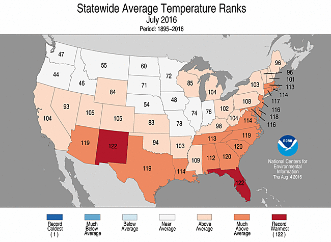
- The July temperature for the contiguous U.S. was 75.3°F, or 1.6°F above the 20th century average, ranking as the 14th warmest on record.
- Above-average temperatures were widespread across the southern half of the nation and along the East Coast. Eighteen states, including Alaska, had July temperatures that were much above average. Florida and New Mexico had their warmest July on record.
- The New Mexico statewide average temperature was 76.8°F, 4.1°F above average, tying July 2003 as the warmest month of any month for the state.
- The Florida statewide average temperature was 84.0°F, 3.0°F above average, and was the second warmest month of any month in the 122-year period of record, behind only June 1998.
- Near- to below-average temperatures were observed across the Northwest, Northern Plains and parts of the Midwest.
- Alaska observed its fourth warmest July in its 92-year record with a statewide temperature of 55.7°F, 3.0°F above average. This was Alaska's warmest July since 2009 and continued a streak of above-average temperatures that began in October 2015. Several locations across southern parts of the state were record warm, including the Ted Stevens Anchorage International Airport which had a monthly average temperature of 62.7°F, the warmest month observed there since records began in 1953.
- The contiguous U.S. average maximum (daytime) temperature during July was 87.9°F, 1.3°F above the 20th century average, the 21st warmest on record. Above-average maximum temperatures were observed across the southern half of the nation and along the East Coast. Florida had a record warm July maximum temperature. Near- and below-average maximum temperatures were observed across the Northwest, Northern Rockies, Great Plains, and Midwest were above-average precipitation suppressed daytime temperatures.
- The contiguous U.S. average minimum (nighttime) temperature during July was 62.5°F, 2.0°F above the 20th century average, the eighth warmest on record. Most of the country experienced above-average minimum temperatures, with near-average minimum temperatures across parts of the Northwest and the Northern Plains and Rockies. Much-above-average minimum temperatures were observed across the Southwest, Southern Plains, Southeast and Mid-Atlantic. South Carolina had its warmest July minimum temperature on record.
- During June there were 4,843 record warm daily high (1,462) and low (3,381) temperature records, which is more than three times the 1,394 record cold daily high (1,027) and low (367) temperature records.
- Based on NOAA's Residential Energy Demand Temperature Index (REDTI), the contiguous U.S. temperature-related energy demand during July was 115 percent above average and the sixth highest value on record, driven in large part to warm temperatures across the densely populated Northeast.
June 2016 Statewide Temperature Ranks
Precipitation
June 2016 Precipitation Ranks
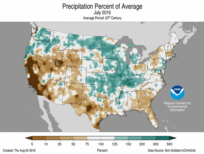
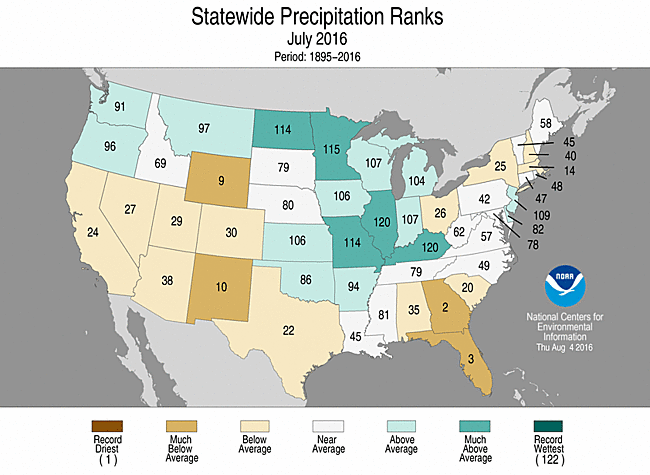
- The July precipitation total for the contiguous U.S. was 2.87 inches, 0.09 inch above the 20th century average, and ranked near the middle value in the 122-year period of record.
- Above-average precipitation was widespread across the Northwest, Northern and Central Plains, and Midwest. Illinois, Kentucky, Minnesota, Missouri and North Dakota each had July precipitation totals that were much above average. Parts of western Kentucky were record wet where heavy rainfall caused widespread flooding.
- Below-average precipitation was observed across the Southwest, Central Rockies, Southern Plains and along parts of the East Coast. Florida, Georgia, New Mexico and Wyoming each had much below average July precipitation. In the Northeast, continued dry conditions contributed to expanding drought.
- On July 24, Tropical Storm Darby made landfall on Hawaii's Big Island with sustained winds of 40 mph. The storm moved to the northwest, skirting southern parts of the state. Heavy rains from Darby caused flooding with precipitation totals exceeding 10 inches in some locations. Darby is only the fifth tropical storm or hurricane to make landfall in Hawaii since records began in 1949.
- According to the August 2 U.S. Drought Monitor report, 21.1 percent of the contiguous U.S. was in drought, up about 4.9 percent compared to the end of June. Drought conditions worsened and expanded across parts of the Southeast, Great Plains and Northeast. Drought reduction was observed across parts of the Upper Midwest and the Hawaiian Islands. Drought and wildfires continued to plague California.
- Climate Highlights — year-to-date (January-June)
 Jan-Jul Average Temperature Departures |
 Jan-Jul Percent of Average Precipitation |
Temperature
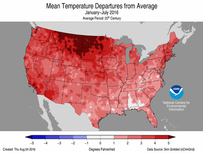
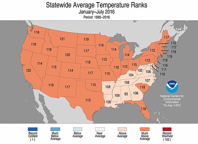
- The year-to-date contiguous U.S. (January-July) temperature was 54.3°F, 3.0°F above the 20th century average, making it the third warmest on record.
- Above-average temperatures spanned the nation for the first seven months of 2016, with every state being warmer than average. Overall, the contiguous U.S. was the third warmest on record. Thirty-eight states across the West, including Alaska, the Great Plains, Midwest and Northeast were much warmer than average, while parts of the Southeast observed above-average temperatures. No state in the contiguous U.S. was record warm.
- Alaska was record warm for the year-to-date with a statewide temperature of 33.9°F, 8.1°F above the 1925-2000 average. This bested the previous record of 31.2°F set in 1981.
- The contiguous U.S. average maximum (daytime) temperature during January-July was 66.2°F, 2.9°F above the 20th century average, the fifth warmest on record. Above-average maximum temperatures spanned the nation, with every state having an above-average year-to-date maximum temperature. Much-above-average maximum temperatures were observed across much of the West, Great Plains, and Northeast.
- The contiguous U.S. average minimum (nighttime) temperature during January-July was 42.3°F, 3.1°F above the 20th century average, the second warmest on record. The January-July 2012 minimum temperature was warmer at 43.1°F. Above-average minimum temperatures were observed for every state, with 40 states having a year-to-date minimum temperature much warmer than average.
- Based on REDTI, the contiguous U.S. temperature-related energy demand during January-July was 60 percent below average and the eighth lowest value on record.
January-June Statewide Temperature Ranks
Precipitation
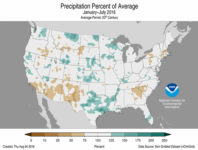
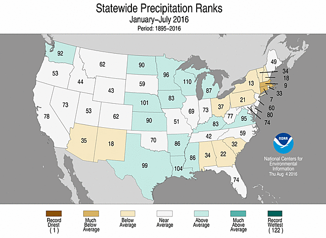
- The year-to-date precipitation total for the contiguous U.S. was 18.49 inches, 0.40 inch above average, and ranked near the middle value in the 122-year period of record.
- Year-to-date precipitation totals across the contiguous U.S. were mixed. Above-average precipitation was observed for parts of the Northwest, Great Plains, Midwest and Mid-Atlantic. Below-average precipitation fell across parts of the Southwest, Southeast and Northeast. No state was record dry or wet for the seven-month period, but Connecticut had its seventh driest year-to-date and Massachusetts its ninth driest.
Jan-June Statewide Precipitation Ranks
Extremes
- The U.S. Climate Extremes Index (USCEI) for the year-to-date was 60 percent above average and the eighth highest value on record. On the national scale, extremes in warm maximum and minimum temperatures, the spatial extent of wetness and one-day precipitation totals were much above average. The USCEI is an index that tracks extremes (falling in the upper or lower 10 percent of the record) in land-falling tropical cyclones, temperature, precipitation and drought across the contiguous U.S.
- On the regional scale, the CEI was much above average in the Northern Rockies and Plains and the South. In the Northern Rockies and Plains, extremes in warm daytime and nighttime temperatures were much above average. In the South, extremes in warm minimum temperatures, the spatial extent of wet conditions, and one-day precipitation totals were much above average.
**A comparison of the national temperature departure from average as calculated by NCDC's operational dataset (nClimDiv), the U.S. Historical Climatology Network (USHCN), and the U.S. Climate Reference Network (USCRN) is available on our National Temperature Index page.**
Regional Highlights:
These regional summaries were provided by the six Regional Climate Centers and reflect conditions in their respective regions. These six regions differ spatially from the nine climatic regions of the National Centers for Environmental Information.
- Northeast Region: (Information provided by the Northeast Regional Climate Center)
- July was a warmer-than-normal month for the Northeast. The region's average temperature of 71.6 degrees F (22.0 degrees C) was 2.0 degrees F (1.1 degrees C) above normal, making it the 15th warmest July since 1895. All twelve states saw above-normal temperatures, with nine ranking this July among their top 20 warmest: Delaware, 5th warmest; Connecticut, 6th warmest; Maryland and New Jersey, 7th warmest; Rhode Island, 9th warmest; Massachusetts, 10th warmest; Pennsylvania, 15th warmest; and New York and West Virginia, 20th warmest. Average temperature departures ranged from 1.1 degrees F (0.6 degrees C) above normal in Maine to 3.0 degrees F (1.7 degrees C) above normal in Delaware. Hartford, Connecticut and Scranton, Pennsylvania had their greatest number of days with a high of at least 90 degrees F (32 degrees C) this July with 17 days and 15 days, respectively.
- July was a warmer-than-normal month for the Northeast. The region's average temperature of 71.6 degrees F (22.0 degrees C) was 2.0 degrees F (1.1 degrees C) above normal, making it the 15th warmest July since 1895. All twelve states saw above-normal temperatures, with nine ranking this July among their top 20 warmest: Delaware, 5th warmest; Connecticut, 6th warmest; Maryland and New Jersey, 7th warmest; Rhode Island, 9th warmest; Massachusetts, 10th warmest; Pennsylvania, 15th warmest; and New York and West Virginia, 20th warmest. Average temperature departures ranged from 1.1 degrees F (0.6 degrees C) above normal in Maine to 3.0 degrees F (1.7 degrees C) above normal in Delaware. Hartford, Connecticut and Scranton, Pennsylvania had their greatest number of days with a high of at least 90 degrees F (32 degrees C) this July with 17 days and 15 days, respectively.
- The U.S. Drought Monitor released on July 7 showed 21 percent of the Northeast was in a moderate or severe drought and 44 percent of the region was abnormally dry. Much of the region received below-normal precipitation during the month, leading to the expansion of drought and abnormally dry conditions. By the end of July, 29 percent of the region was in a moderate or severe drought and 37 percent of the region was abnormally dry. There were numerous impacts from the drought. Streamflow was at record or near record low levels and groundwater and reservoir levels were below normal in parts of New York, New England, northern New Jersey, and northern Pennsylvania. Water bans and restrictions were in place in more than 130 Massachusetts towns and more than 50 New Hampshire towns. Yields of corn and second cuttings of hay were expected to be lower than usual. Pastures and crops were stunted, and wild blueberries and apples were smaller in size. Many farmers irrigated, but some reported dried up wells and ponds. There was also increased fire activity. In Massachusetts, there were several lightning strike fires in late July, which is unusual for the state. Dead fuel moisture, the amount of water in dead vegetation (fuel), was historically low for late July in the state. When fuel moisture is low, fires can start easily and spread rapidly. A Drought Watch was declared for New York (for the first time since 2002) and northern New Jersey. In addition, a Drought Advisory was issued for southeastern Massachusetts and the Connecticut River Valley, while a Drought Watch was issued for central and northeastern Massachusetts.
- Severe thunderstorms moved through the Northeast frequently in July. There were seven weak tornadoes and several straight line wind events, with wind speeds of up to 100 mph (45 m/s). Hundreds of trees were uprooted or snapped, and there was some structural damage to homes and outbuildings. Flash flooding accompanied many storms. On July 30, extreme rainfall fell in Howard and Montgomery counties in Maryland. According to the National Weather Service, Ellicott City received 5.96 inches (151.38 mm) of rain in 2 hours, making it a 1,000-year event. Rainfall of that magnitude has a 0.1% chance of occurring in a given year. The heavy rainfall led to a rapid rise of the Patapsco River (preliminary data shows it rose 13.13 feet (4 m) in 1.5 hours), causing significant flash flooding in the city. Numerous buildings and hundreds of vehicles sustained damage.
- For more information, please go to the Northeast Regional Climate Center Home Page.
- Midwest Region: (Information provided by the Midwest Regional Climate Center)
- July temperatures, when averaged for the month, were close to normal for most of the Midwest. Temperatures were within 2 degrees F (1 C) of normal for most of the region, with smaller areas averaging 2 to 4 degrees F (1 to 2 C) above normal along the southern and eastern edges of the region. The monthly averages were not reflective of the day-to-day variations in July however. The first few days of the month were well below normal and the latter half of the month was hot and humid. Temperatures for the 1st to the 4th averaged as much as 10 degrees F (6 C) below normal from the Iowa-Missouri border to northern and central Indiana. To the north and south the temperatures were still below normal but were closer to normal near the north and south edges of the region. Temperatures fell below 40 degrees F (4 C) in Minnesota, Michigan, and Ohio and to below 50 degrees F (10 C) in Wisconsin, Iowa, Illinois, and Indiana. Later in July hot and humid conditions developed, the third week of the month was particularly hot and humid and the warmth remained to a lesser degree through the end of the month. Temperatures only reached 100 degrees F (38 C) at a handful of Midwest stations, mostly in Missouri, but did climb to within a few degrees of the century mark in all nine states. Humidity levels were quite elevated with dewpoint temperatures above 80 degrees F (27 C) and heat index values soaring above 110 degrees F (43 C) at numerous locations.
- July was very wet for most of the Midwest. Statewide precipitation totals were above normal in every Midwest state except Ohio, which ranked tied for the 19th driest July on record (1895-2016). On the other hand, four states ranked among the 10 wettest over the same 122-year period of record. Kentucky ranked 2nd wettest, Illinois 3rd, Minnesota 4th, and Missouri 8th. Precipitation exceeded 5 inches (127 mm) for most of the region with 10-inch (254 mm) areas also widespread. An area in western Kentucky exceeded 15 inches (381 mm) for numerous stations. Dozens of stations in seven states recorded 10 or more inches (254 mm) of rain and 10 stations in four states exceeded 15 inches (381 mm) in July. The northern two-thirds of Ohio and northeast Indiana received only 25 to 50 percent of its normal July rainfall total. The highest rainfall totals in Kentucky was 18.67 inches (474 mm) at Madisonville, in Missouri was 17.04 inches (433 mm) at Brumley, in Minnesota was 16.58 inches (421 mm) at Ortonville, and in Illinois was 16.13 inches (410 mm) at Downers Grove.
- With heavy rain events during July, flooding and flash flooding were a problem in many parts of the Midwest. Flooding on the 11th and 12th in northeast Minnesota and northwest Wisconsin was the worst since in the area since June 2012. There were three confirmed deaths due to this event.
- Severe weather was common in July with hundreds of reports spread across the entire Midwest. Only two days, the 1st and 2nd, had no severe convective weather reports during July. July 13th was the busiest day with more than 500 reports, predominantly thunderstorm wind damage. Six other days, 5th-8th and 20th-21st, also had more than 100 severe weather reports. Tornadoes were reported on 12 days in July in eight states. Large hail, 1.00 inch (2.54 cm) in diameter or greater, was reported in all nine states with very large hail, 2.50 to 3.00 inches (6.35 to 7.62 cm), reported on 4 days in Minnesota and one day in Michigan. On the 20th, trees were felled by thunderstorm winds killing two people at a scout camp in northern Minnesota. A tornado in Metropolis, Illinois on the 6th was responsible for two injuries.
- The lack of rain in Ohio led to the introduction and expansion of moderate drought in the state during July (33 percent of Ohio). Drought also was introduced in Lower Michigan (16 percent of the state). The areas in the western half of the region that were in drought to begin the month saw improvements in their status with the heavy rains.
- Corn and soybean crops in the Midwest were rated about the same condition as each other in most of the states. Ohio and Michigan showed the most concern with both crops rated good or excellent in only 54 to 58 percent of fields. The other seven states in the region had good or excellent conditions for more than 70 percent of these two key crops. Ohio and Michigan were also reported to have the highest percentage of both topsoil and subsoil moisture in the region. These two states had about half their acreage in the short or very short categories while the other seven states reported less than 20 percent in those two categories.
- For further details on the weather and climate events in the Midwest, see the weekly and monthly reports at the Midwest Climate Watch page.
- Southeast Region: (Information provided by the Southeast Regional Climate Center)
- Temperatures were well above average across the Southeast region, with numerous record-breaking extremes observed during July. Mean temperature departures were 2 to 4 degrees F (1.1 to 2.2 degrees C) above average across much of the region, with a few locations in Georgia and the Carolinas reaching 5 degrees F (2.8 degrees C) above average. A total of 22 long-term (i.e., period of record exceeding 50 years) stations across the region, with over half of these located in Florida, observed or tied their warmest July mean temperature on record. A few of these stations include Daytona Beach, FL (84.1 degrees F; 28.9 degrees C), Orlando, FL (85.2 degrees F; 29.6 degrees C), Charleston, SC (86.2 degrees F; 30.1 degrees C), and Columbia, SC (87.2 degrees F; 30.7 degrees C). Several stations observed a maximum temperature at or above 90 degrees F (32.2 degrees C) on all 31 days during the month, including Daytona Beach, FL (highest count for any month on record, 1923-2016) and Athens, GA (tied for the highest count for any month on record, 1893-2016). On the 3rd, the University of South Carolina station (1955-2016) in Columbia tied its third warmest maximum temperature for July on record, reaching 107 degrees F (41.7 degrees C). During the month, at least three fatalities in South Carolina were attributed to hyperthermia (a key symptom of heat-related illness), with two of these occurring in the Columbia metropolitan area. From the 24th through the 27th, Washington, D.C. (1872-2016) tied its second longest streak of four days with a minimum temperature at or above 80 degrees F (26.7 degrees C). Temperatures were also well above average in Puerto Rico and the U.S. Virgin Islands during the month, as Guayama, PR (1914-2016) observed its warmest mean temperature for July on record (85.5 degrees F; 29.7 degrees C). The warmest weather of the month occurred from the 24th through the 26th, as the Bermuda High expanded westward across the Southeast. Daily maximum temperatures exceeded 95 degrees F (35 degrees C) across broad portions of every state in the region, with several locations reaching or exceeding 100 degrees F. In contrast, the coolest weather of the month occurred on the 16th, as widespread thunderstorm activity suppressed daytime temperatures across the region.
- Precipitation was highly variable across the Southeast region during July, with numerous extremes recorded. The driest locations were found across the southern portion of the region, including much of Georgia as well as parts of central Alabama, central and western South Carolina, the Florida Panhandle, and the eastern coast of the Florida Peninsula. Monthly precipitation totals were between 10 and 50 percent of normal in these areas. A total of 11 long-term (i.e., period of record exceeding 50 years) stations in Georgia and Florida observed their driest or second driest July on record, including Columbus, GA (0.96 inch; 24.4 mm), Savannah, GA (1.21 inches; 30.7 mm), Daytona Beach, FL (0.71 inch; 18 mm), and Vero Beach, FL (0.61 inch; 15.5 mm). In contrast, the wettest locations were found predominately across the northern portion of the region, including parts of eastern South Carolina, western and eastern North Carolina, and eastern Virginia. Monthly precipitation totals were between 150 and 300 percent of normal in these areas. On the 16th, training thunderstorms caused a significant flash flooding event within the Triangle region of North Carolina (i.e., Raleigh, Durham, and Chapel Hill), resulting in numerous road closures and water rescues. For this event, the greatest 1-day precipitation total of 7.52 inches (191 mm) was recorded by a CoCoRaHS gauge in Cary, NC. On the 31st, Norfolk, VA (1874-2016) observed its wettest July day and fifth wettest day all time with 6.98 inches (177 mm) of precipitation. Precipitation was above normal across much of Puerto Rico and the U.S. Virgin Islands during the month, with departures exceeding 8 inches (203 mm) above normal over a broad area of western Puerto Rico.
- There were 1,170 severe weather reports across the Southeast during the month, which is well above normal (based on the median frequency of 788 reports for July during 2000-2015). At least one severe weather report was recorded within the region on all but one day (29th) during the month, but nearly 40 percent of the reports (451 of 1,170) occurred on just four of these days (6th, 7th, 8th, and 19th). At least 70 severe weather reports were recorded in every state across the region, with the greatest numbers occurring in North Carolina (304; 26 percent of total) and South Carolina (265; 23 percent of total). Strong thunderstorm winds accounted for nearly 95 percent (1,097 of 1,170) of the severe weather reports during July and were responsible for seven injuries across the region. On the 8th, winds associated with a vigorous squall line downed trees and power lines across a large swath of Watauga and Wilkes Counties in North Carolina, resulting in one reported injury when a tree fell onto an occupied vehicle. An 87 mph wind gust was recorded on Grandfather Mountain, as the line of thunderstorms moved through western North Carolina. Only two tornadoes (1 EF-0, 1 unrated), both occurring in Florida, were confirmed across the region during the month, which is well below the short term (2000-2015) median frequency of 11 tornadoes observed during July. A total of four fatalities and 14 injuries were caused by lightning strikes across the region. On the 6th, four agricultural workers were injured by a lightning strike while harvesting peaches in Edgefield County, SC. On the 16th, a motorcyclist was killed by a lightning strike on the Blue Ridge Parkway near Mt. Mitchell State Park in North Carolina. On the 20th, a lightning-induced fire destroyed the Nature Center at Huntington Beach State Park near Myrtle Beach, SC, killing all animals inside.
- Drought conditions intensified and expanded in coverage across several areas of the Southeast region during July, including northern and central Georgia as well as western portions of the Carolinas. The percentage of the region under drought-free conditions (less than D1) decreased from 83 percent on June 28th to 81 percent on July 26th. The coverage of moderate-to-extreme (D1-D3) drought across Alabama remained around 40 percent during the month. Extreme drought conditions expanded in coverage by 9 percent during the month across parts of northern Georgia, and an area of moderate drought developed in the central portion of the state. Drought conditions (D1 and greater) doubled in coverage across western South Carolina, including the emergence of a localized area of extreme drought along the northwestern border with Georgia. A small area of southeastern Puerto Rico remained in moderate drought during the month. Field crops (corn, soybeans, cotton, and tobacco) were highly stressed by the persistent excessive heat and the lack of rainfall across much of the region, and this will likely reduce the quality of yields at harvest. The corn crop in Alabama and Georgia was especially affected by the hot, dry weather during the month, with substantial losses reported in many fields. In drought-stricken portions of the region, many livestock producers continued a supplemental feeding for their herds, as some pastures became infested with fall armyworms. Hail and high winds from severe thunderstorms damaged several corn and tobacco fields across North Carolina.
- For more information, please go to the Southeast Regional Climate Center Home Page.
- High Plains Region: (Information provided by the High Plains Regional Climate Center )
- The month of July brought a variety of climate conditions to the High Plains region, as some places were wet while others were dry, and temperatures were both cool and warm at times. The western High Plains experienced warmer and drier conditions, causing streamflows to run low and drought to expand and intensify in western South Dakota/northeastern Wyoming. In Colorado, top 10 records for warmest July were set in Pueblo (2nd warmest), Alamosa (6th warmest), and Colorado Springs (7th warmest). Several locations in Wyoming had a top 5 driest July, including Lander (tied for driest), Rawlins (4th driest), Casper (4th driest), and Laramie (5th driest). In the eastern High Plains, many locations enjoyed unseasonably cool temperatures over the 4th of July weekend, but a heat wave occurred in the latter part of the month, prompting the issuance of excessive heat warnings by the National Weather Service. It was also much wetter in this part of the region, and top 10 records for wettest July were set in North Dakota at Bismarck (6th wettest), Dickinson (7th wettest), and Fargo (10th wettest), as well as Wichita, Kansas (2nd wettest).
- The climate conditions in July impacted several sectors around the region. The heat wave that was previously mentioned caused stress to spring wheat in South Dakota and fledglings in the northern Plains and into the Midwest. Soil moisture declined in July across most of the region except North Dakota, and crop stress was evident in areas where drought was present. The occurrence of wildfires increased, particularly across Wyoming, Colorado, and South Dakota. However, above-normal temperatures over the past few months have had positive impacts such as accelerated crop growth in the Dakotas, and ideal field conditions have allowed small grains to be harvested much earlier than usual. Additionally, timely rainfall in the eastern Dakotas brought beneficial moisture as corn was beginning to tassel, and row crop conditions improved. In Kansas, cooler and wetter weather benefited developing sorghum, but a storm system that brought excessive rainfall in early July caused flooding in and around the city of Wichita.
- On the whole, temperatures were closer to average in the High Plains region in July, as most locations were between 1.0 degrees F (0.6 degrees C) below normal and 2.0 degrees F (1.1 degrees C) above normal. However, the first half of the month was cooler than normal in the northern and eastern parts of the region, while the latter half was much warmer, so monthly temperatures came out close to average in these areas. The primary exception was in parts of Colorado, where it was much warmer and temperatures were 2.0-5.0 degrees F (1.1-2.8 degrees C) above normal. Pueblo, Colorado was especially warm, as this location experienced not only its 2nd warmest July, but its 2nd warmest month on record as well (period of record 1888-2016). Only July 2003 was warmer in Pueblo.
- A cool spell occurred during the first week of the month across the eastern High Plains, which was a welcomed break from the heat experienced in June. The 4th of July weekend was rather pleasant, especially in eastern Nebraska and eastern Kansas. In fact, record cool daily maximum temperatures were set on the 3rd in Nebraska at Lincoln and Norfolk, as well as in Kansas at Concordia and Topeka. The heat returned during the latter half of the month, however, and a heat wave occurred from the 20th-22nd across the eastern High Plains and parts of the Midwest. A combination of heat indices of at least 110.0 degrees F (43.3 degrees C), warm nighttime low temperatures of around 80.0 degrees F (26.7 degrees C), and high relative humidity created very uncomfortable conditions and posed a danger to those who are particularly sensitive to heat. As a result of these conditions, numerous National Weather Service Weather Forecast Offices issued excessive heat warnings and heat advisories across the area.
- The region experienced a mix of wetter and drier conditions in July. The western High Plains, particularly Wyoming and Colorado, had a very dry July while the eastern High Plains were mostly wet, especially in North Dakota, central Nebraska, and Kansas. The differences in precipitation were extreme across the region, as locations in Wyoming and Colorado had a top 10 driest July on record, while North Dakota and Kansas experienced record wetness.
- The dryness in Wyoming was especially pronounced, as a large portion of the state received only 25 percent of normal precipitation for the month, at best. Several top 5 driest Julys on record were set. Only a trace of precipitation was recorded at Hunt Field Airport in Lander, Wyoming, tying 1901 and 1917 for the driest July on record (period of record 1892-2016). The dry weather in July followed a very dry June in Wyoming, causing drought to expand and intensify. Wildfires were burning in several of the state's forests. Despite the dryness over the past two months, the spring was so wet in parts of Wyoming that some locations, such as Lander and Casper, have already received enough precipitation to have a top 10 wettest year on record.
- Some of the wettest areas in the region included parts of North Dakota and Kansas, where precipitation was more than 200 percent of normal. The most impressive precipitation records were set in Wichita, Kansas, which ended the month at 6.35 inches (161 mm) above normal and had its 2nd wettest July on record (period of record 1888-2016). On the 2nd, Wichita received an astounding 5.72 inches (145 mm) of precipitation, which was the highest 1-day total precipitation on record for July, crushing the previous record of 3.52 inches (89 mm) set in 1950. July 2nd also became the 6th highest 1-day total precipitation recorded in any month for Wichita.
- Adequate precipitation is very important during this part of the growing season, as some crops are entering critical growth stages. For example, moisture is especially needed when corn begins to tassel. Fortunately, dry areas in the eastern Dakotas received beneficial rainfall during this corn growth stage, and row crop conditions improved. Cooler, wetter weather in Kansas benefited developing sorghum. However, soil moisture continued to decline in July throughout much of the High Plains, which could cause crop conditions to worsen and impact yields should conditions not improve.
- Streamflows were running much below normal across the northern half of Wyoming and in western South Dakota in July. The early melting of mountain snowpack and very little precipitation during the month were to blame for low streamflows in Wyoming. The presence of drought in western South Dakota was taking its toll on streamflows there, and water quantity and quality issues were being reported. Streamflows were mostly normal in Colorado despite a dry July, although there were some exceptions in the southern part of the state. This area was much warmer, and the spring supply of snowmelt and soil moisture began to diminish, causing a decline in streamflows and reservoir levels. Streamflows were running much above normal in locations in the High Plains where rainfall was ample, such as in North Dakota, northern and central Nebraska, and Kansas.
- Drought and abnormal dryness expanded and intensified across much of the region in July due to the lack of adequate rainfall in areas that needed it most. The July 26th release of the U.S. Drought Monitor indicated that approximately 35 percent of the High Plains region was experiencing drought or abnormal dryness (D0-D4), compared to about 28 percent at the end of June. Reports of impacts became more common as conditions continued to worsen. However, wetter conditions prevailed in areas of the eastern High Plains, which allowed for improvement of drought and dryness in some areas.
- The area in drought in the Black Hills of South Dakota extending into northeastern Wyoming was faring the worst in the region, as the area received little drought relief in July after enduring a very dry June. Impacts that have been reported include low alfalfa yields, little hay production, water quantity and quality issues, and wildfires. Moderate drought (D1) began to spread from this area into central South Dakota and the Nebraska panhandle. Another area of drought that intensified was in the Bighorn Mountains of northern Wyoming, where drought has been present since the snowpack season and precipitation has been abysmal so far this summer.
- As for improvements, ample precipitation fell in the eastern Dakotas in July, providing some relief from drought conditions in the area. Also, abnormal dryness (D0) was nearly erased in eastern Kansas due to impressive July rainfall totals.
- For more information, please go to the High Plains Regional Climate Center Home Page.
- Southern Region: (Information provided by the Southern Regional Climate Center)
- July temperatures were generally above average in the Southern Region, with all six states averaging warmer than the monthly expected values. Temperature anomalies ranged from 0 to 4 degrees F (0-2.22 degrees C) above normal for most stations, except in western Texas, where a bulk of the stations there averaged between 4-6 degrees F (2.22-3.33 degrees C) above normal. The statewide monthly average temperatures were as follows: Arkansas reporting 82.10 degrees F (27.83 degrees C), Louisiana reporting 83.60 degrees F (28.67 degrees C), Mississippi reporting 82.60 degrees F (28.11 degrees C), Oklahoma reporting 83.40 degrees F (28.56 degrees C), Tennessee reporting 79.80 degrees F (26.56 degrees C), and Texas reporting 85.50 degrees F (29.72 degrees C). The state-wide temperature rankings for May are as follows: Arkansas (twentieth warmest), Louisiana (ninth warmest), Mississippi (fourteenth warmest), Oklahoma (twenty-ninth warmest), Tennessee (tenth warmest), and Texas (fourth warmest). All state rankings are based on the period spanning 1895-2016.
- Precipitation totals for the month of July varied spatially over the Southern Region, with much of the northern half of the region experiencing a wetter than normal month, and by contrast, drier than normal conditions in the southern half of the region. The wettest portions included much of northern Arkansas and eastern Oklahoma, where many stations reported over 150 percent of normal precipitation for the month. Similar values were also observed in north central Tennessee and in the Louisiana-Arkansas-Mississippi border region. Conditions were quite dry in eastern and southern Texas, with stations reporting little to no precipitation for the month. Many stations reported less than 10 percent of normal for the month. The state-wide precipitation totals for the month are as follows: Arkansas reporting 4.85 inches (123.19 mm), Louisiana reporting 5.02 inches (127.51 mm), Mississippi reporting 5.46 inches (138.68 mm), Oklahoma reporting 3.60 inches (91.44 mm), Tennessee reporting 4.87 inches (123.70 mm), and Texas reporting 1.31 inches (33.27 mm). The state precipitation rankings for the month are as follows: Arkansas (twenty-ninth wettest), Louisiana (forty-fifth driest), Mississippi (forty-second wettest), Oklahoma (thirty-seventh wettest), Tennessee (forty-fourth wettest), and Texas (twenty-second driest). All state rankings are based on the period spanning 1895-2016.
- Drought conditions across the Southern Region have worsened over the past month. In central Mississippi, many counties have been downgraded from moderate drought to severe drought as conditions there have been consistently drier than normal. There is also a new small pocket of moderate and severe drought in south eastern Oklahoma and north eastern Texas. Conditions in central Texas were quite dry this past month and many counties are now identified as abnormally dry. This is also the case in west-central and south western Arkansas.
- On July 14, strong winds were reported across much of western Arkansas and eastern Oklahoma. Wind reports indicated wind speeds between 60-70 mph (96.56-112.70 kph) in Kay County, Oklahoma and in Hot spring County, Arkansas. One injury was reported in Polk county Arkansas. Although some minor damage was reported, most of the damage was restricted to trees and power lines.
- There were only a small handful of tornadoes in the Southern Region in July. Many of them were just brief touchdowns. No tornado-related injuries or fatalities were reported.
- In Texas, excessive rain early in July, followed by a prolonged period of dry conditions, took its toll on farmers. Non-irrigated fields in areas seeing little rain are dealing with partial to near total losses. Rice farmers are seeing highs over 100 degrees F (37.78 degrees C) and lows above 77 degrees F (25 degrees C), not allowing plants stressed during the day any reprieve at night. Excessive heat is also lowering the quality of livestock, which are spending more time cooling than feeding, and lowering hay quality. Regions that did see rain were impacted by hail and excess saturation; at one farm about 300 peach trees were examined and they could not find any peaches worthy to save and sell. The B & G Gardens in Poolville lost 60 percent of their peach crop due to worms because they were unable to spray their 240 trees from excess water. The development of flash drought was a concern in many parts of Texas during July, as many places had not seen more than half an inch of rainfall since the beginning of June, notably in northeast Texas near Texarkana. Drought conditions progressively worsened throughout the month as areas went longer and longer with no rainfall. Wildfires due to high surface evaporation were common throughout the month, including Del Valle, where 10 acres were burned (Information provided by the Texas Office of State Climatology).
- The National Weather Service had to give heat advisories often this month. Heavy power usage caused an electrical spike, leaving 12,000 people with no power for a couple days in Ector County. Four people died in El Paso due to the heat. Three of the deaths were from heat stroke and the fourth was from heat exposure. One hiker died from a heat stroke in a Texas park. Lastly, four children died in hot cars, each from different states and one was a 2-year- old boy from Texas (Information provided by the Texas Office of State Climatology).
- For more information, please go to the Southern Regional Climate Center Home Page.
- Western Region: (Information provided by the Western Region Climate Center)
- July average temperatures were slightly cooler than normal across the northern tier of the West this month, and slightly above normal across much of the Southwest. Scattered areas of above normal precipitation were recorded across Northwest. In the Southwest, a break in monsoon activity was observed in the first half of the month, with a return to monsoon conditions in the latter half of the month.
- A trough passing over the Northwest July 8-11 brought precipitation to many locations across the northern tier of the region, supporting above normal monthly totals. Thunderstorms and a smaller disturbance in the latter half of the month also contributed to precipitation totals for some inland locations, though generally to a lesser extent. In northern California, Crescent City observed 1.03 in (26 mm) rainfall, 251% of normal and the wettest July in a 68-year record. On the Washington-Idaho border, Lewistown logged 1.57 in (40 mm) precipitation, 238% of normal and the 7th wettest July in a 69-year record. Further east, Missoula, Montana recorded 2.06 in (52 mm) for the month, the 5th wettest July since 1948. In the Southwest, precipitation at Tucson, Arizona, totaled 3.32 in (84 mm), 148% of normal for the month. Southern and central Utah also observed some areas of above normal precipitation; Ferron logged 1.2 in (30 mm) precipitation, 151% of normal.
- Several Southwest locations saw below normal precipitation. Salt Lake City, Utah, recorded no measurable July precipitation for only the second time since records began in 1928. Normal July precipitation for Salt Lake City is 0.61 in (15 mm). Monsoon activity favored Arizona this month, leaving many areas of New Mexico drier than normal. In eastern New Mexico, Roswell saw only one day of precipitation totaling 0.45 in (11 mm), 22% of normal. This was the 16th driest July in a 124-year record. In southwestern New Mexico, Hachita reported only 33% of normal precipitation. Further north, Lander, Wyoming, reported no measurable July precipitation for the first time since its record began in 1946. Normal July precipitation for Lander is 0.78 in (20 mm). Most of California received little to no precipitation this month, as is typical for July. Drier than normal conditions allowed for drought conditions to develop or increase in severity along the Oregon coast, western Montana, eastern New Mexico. Along the eastern Wyoming-Montana border, extreme drought conditions are now present. Only very small areas of improvement were seen this month in the New Mexico panhandle and eastern Idaho.
- Average temperatures across the West were generally within 2-4 F (1-2 C) of normal, with the exception of New Mexico. A notable heat wave impacted much of the West July 26-29, with average temperatures of 5-10+ F (3-5 C) above normal, though high temperatures were not unprecedented. Las Vegas, Nevada, reported a high temperature of 115 F (46.1 C) on July 27 and 28, tie with 18 other years for 11th warmest July temperature on record. Temperatures at Las Vegas averaged to 95.4 F (35.2 C), 2.9 F (1.6 C) above normal and the second warmest July since records began in 1948. Further east, Roswell, New Mexico, had its warmest July on record at an average 86.5 F (30.3 C), 6.2 F (3.4 C) above normal. In the Northwest, temperatures trended cooler than normal. In the Idaho Panhandle, Moscow recorded an average 81 F (27.2 C) for the month, 2.6 F (1.4 C) below normal.
- Temperatures in coastal regions of Alaska were generally above normal this month, reflecting strong positive sea-surface temperature anomalies; inland areas saw more moderate temperatures. Anchorage recorded an average July temperature of 62.7 F (17.1 C), 3.9 F (2.2 C) above normal and the warmest July since records began in 1952. Much of Alaska's Interior observed above normal precipitation; Fairbanks recorded 4.97 in (126 mm) for the month, 230% of normal and the 3rd wettest June since records began in 1929. Further south, above normal precipitation was reported in many locations in Hawaii, much of it resulting from Tropical Storm Darby. Kaneohe, Oahu, recorded 10.75 in (273 mm) for the month, 7.65 in (194 mm) of which fell on the 25th. This was 400% of normal and the wettest July since records began in 1905.
- July (all month): Large Fires in the West: Several large fires impacted the West this month, notably in California and Nevada. At month's end, the Soberanes Fire in coastal central California, grew to 40,600 acres (16,400 hectares) by month's end, destroyed 57 homes, and was only 18% contained. In southern California, the Sand Fire burned over 41,000 acres (16,600 hectares) and destroyed 18 homes. In northern Nevada, the Hot Pot Fire, fueled by brush, burned over 122,000 acres (49,000 hectares) in a week. The fire grew at a rate of 10,000 acres (4,000 hectares) per hour during a period of strong winds on July 2-3.
- July 24-25: Tropical Storm Darby impacts Hawaiian Islands: TS Darby resulted minor to moderate flooding, high surf, power outages, and road closures on Oahu, Maui, and Big Island. Some areas of eastern Oahu received 5-7+ in (127-178 mm) of rain in a single day. Peak wind gusts of 50-60 mph (80-97 kph) were reported on Big Island.
- For more information, please go to the Western Regional Climate Center Home Page.