National Overview:

- Climate Highlights — Spring (March - May)
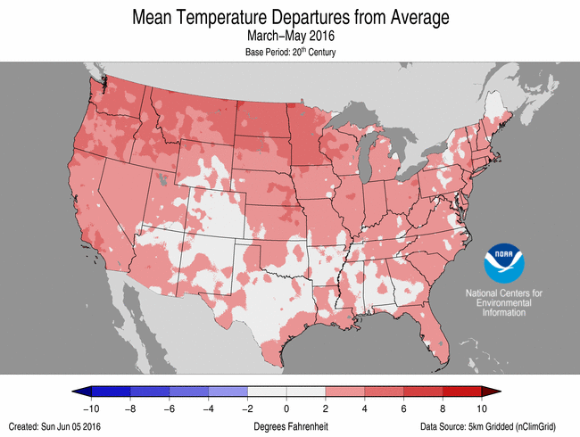 Spring (March-May) Average Temperature Departures |
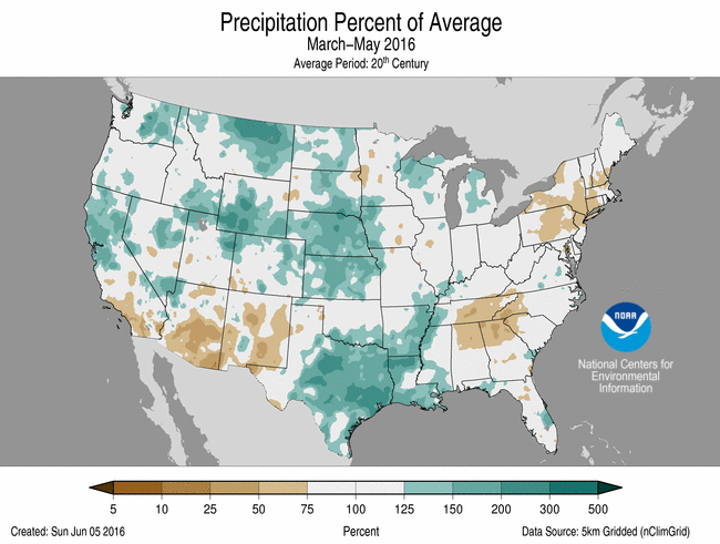 Spring (March-May) Percent of Average Precipitation |
Temperature
- Despite a near-average May, warmth in March and April fueled the warmest spring in the contiguous U.S. since the record-breaking spring of 2012. As has been the case for much of this decade, overnight temperatures were generally relatively higher than afternoon temperatures when compared to average.
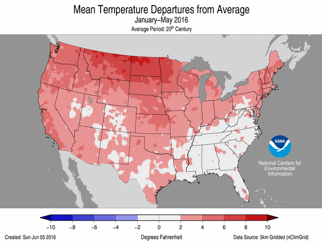
- Every state had a spring temperature that was above average. Fifteen states observed much-above-average temperatures. The highest spring temperatures, relative to history, occurred in the Northwest and much of the northern tier. Washington had its second warmest spring on record, while Oregon had its third warmest.
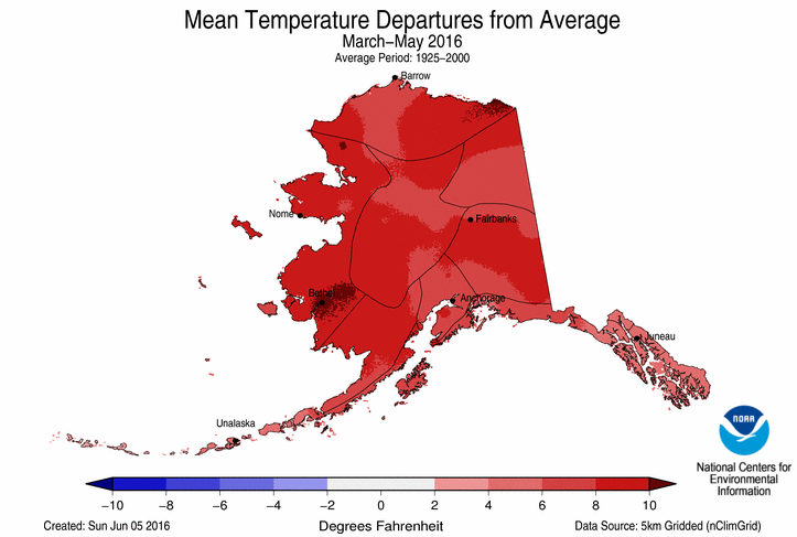
- For the first time in Alaska's modern climate record, its average spring temperature hit 32.0°F. This was easily Alaska's warmest spring on record, eclipsing the previous record set in 1998 by 2.0°F.
- For the period, Washington had its warmest minimum temperature (overnight low) in the 122-year record. This was primarily driven by the warmest April on record for the state. Minimum temperatures for April were 5.7°F above average.
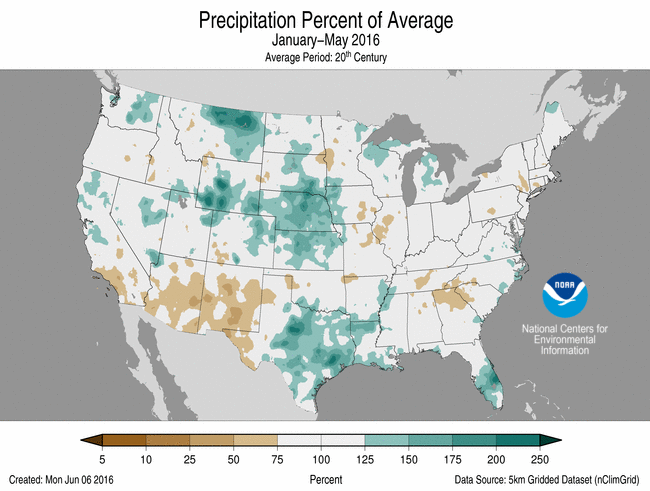
- When averaged across the contiguous U.S., the national precipitation total of 9.03 inches was 1.09 inches above the 20th century average and registered as the nation's 18th wettest spring in the 122-year record.
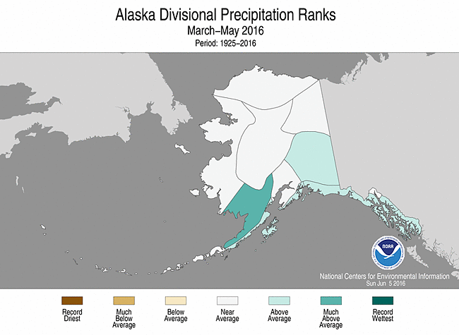
- Above-average spring precipitation fell across most of the area between the Mississippi River and the Pacific Coast. Nebraska, Wyoming, Louisiana and Texas saw much above-average precipitation. Alaska was also wetter than average for the season. Dryness prevailed in the Northeast, where New York and Connecticut observed much drier-than- average spring precipitation totals.
- Parts of central and eastern Texas, northern Louisiana, and eastern Arkansas had precipitation totals that were 10-15 inches greater than their 20th century average. This was driven by a persistently strong flow of Gulf of Mexico moisture which fueled intense rain showers for several consecutive days. In an area between Houston and College Station, 15-20 inches of rain fell in both April and May separately. That equates to more than four times as much rain as typically seen during the 2-month period.
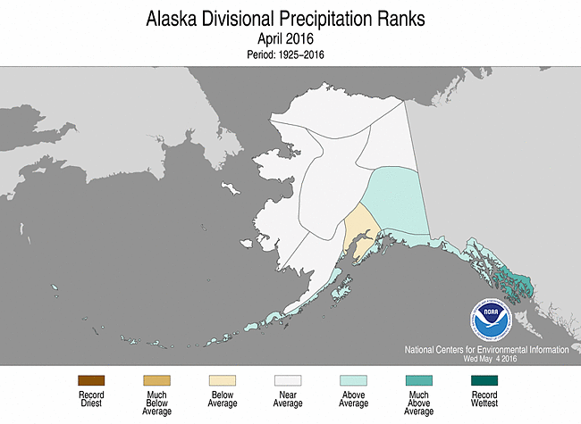
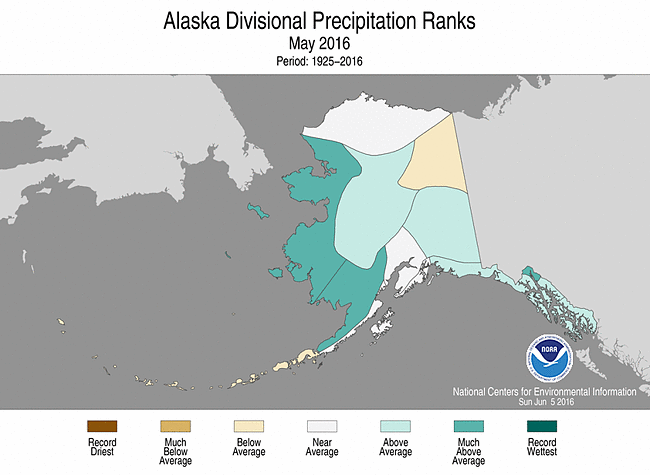
- In Alaska, precipitation was variable during March, April, and May. But for the spring season, the southern part of the state measured above to much-above average precipitation. Some areas received five times the precipitation typically expected in the spring.
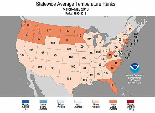
Spring (March-May) 2016 Statewide Temperature Ranks
Precipitation

Spring 2016 Precipitation Ranks
- Climate Highlights — May
 May Average Temperature Departures |
 May Percent of Average Precipitation |
Temperature
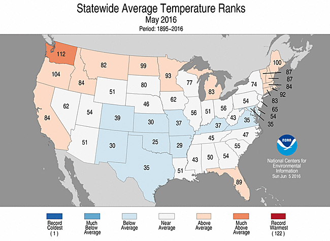
- The average May temperature for the contiguous U.S. was 60.3°F, just 0.1°F warmer than the 20th century average and near the middle of the 122-year record.
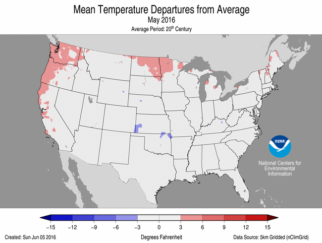
- Below-average May temperatures stretched from a slice of the Mid-Atlantic to a broad region of the Southern Plains and Southern Rockies. Warmer-than-average conditions prevailed across the nation's northern tier. A pocket of much-above-average temperatures occurred in the Pacific Northwest.
- Alaska had its second warmest May on record with a statewide temperature of 44.0°F, 6.0°F above average and 1.0°F shy of its May record set in 2015.
- During May there were 2,122 record warm daily high (771) and low (1,351) temperature records. Conversely, there were 2,061 record cold daily high (1,547) and low (514) temperature records.
- Based on NOAA's Residential Energy Demand Temperature Index (REDTI), the contiguous U.S. temperature-related energy demand during May was the 25th lowest value on record. The spring value was the 3rd lowest on record.
May 2016 Statewide Temperature Ranks
Precipitation

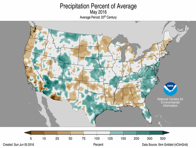
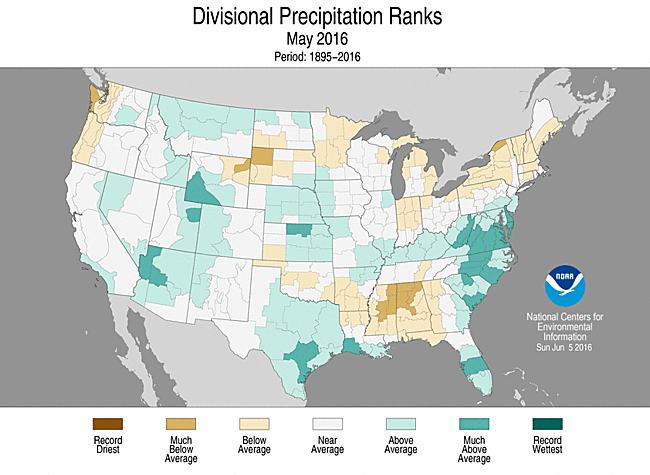
May 2016 Precipitation Ranks
- Precipitation averaged across the contiguous U.S. was 3.04 inches, which is 0.13 inch above the 20th century average.
- Above-average precipitation was observed in parts of the Rockies, Plains, Southwest and Atlantic Coast, where Delaware and Virginia each observed their fifth wettest May on record. Below-average precipitation was focused across the Northeast, Southeast, and parts of the Midwest and Northwest.
- In central and eastern Texas, torrential late May rains, on top of generally wet conditions from earlier in the spring, led to severe flooding that lasted into early June.
- According to the May 31 U.S. Drought Monitor report, 12.7 percent of the contiguous U.S. was in drought, down considerably from 15.4 percent in late April. Drought conditions improved or were eliminated in parts of the Great Basin and Plains. Drought also improved somewhat in northern California and Nevada but persisted in the southern half of California. Drought developed in parts of the Southeast and southern Appalachians. Outside of the contiguous U.S., there was little drought relief for Hawai'i during May; drought generally persisted, although there was a modest contraction on the Big Island. Drought conditions improved across Puerto Rico.
- Climate Highlights — year-to-date (January-May)
 Jan-Mar Average Temperature Departures |
 Jan-Mar Percent of Average Precipitation |
Temperature
- The average year-to-date temperature for the contiguous U.S. was 46.6°F, 3.2°F above the 20th century average and the fourth warmest in the 122-year record.
- Every state was warmer than average for the period. Twenty-nine states across the West, Great Plains, Midwest and Northeast were much warmer than average.
- As was the case through April, Alaska's year-to-date average temperature through May was record warm. The January-May value of 26.1°F was 10.3°F above the 1925-2000 average and 2.4°F higher than the previous record of 23.7°F set in 1981. The last three January-May periods have been three of the four warmest on record for Alaska.

Jan-May Statewide Temperature Ranks
Precipitation
- Above-average precipitation prevailed for the contiguous U.S. as the average year-to-date precipitation was 13.1 inches, 0.7 inch more than the 20th century average, ranking near the middle of the historical record.
- Above-average precipitation occurred in the Central Plains, northern High Plains and Rockies, and parts of Arkansas, Louisiana and Texas. Below-average precipitation was observed for much of the Southwest, Midwest, Southeast and Northeast.
- At the state level, only Nebraska experienced a much-above year-to-date precipitation total, with a 5-month total of 12.03 inches—the seventh wettest start to the year. No state had much-below average precipitation.

Jan-May Statewide Precipitation Ranks
Extremes
- The U.S. Climate Extremes Index (USCEI) for the year-to-date was 40 percent above average and the 16th highest value on record. On the national scale, extremes in warm maximum and minimum temperature and the spatial extent of wetness were much above average. The USCEI is an index that tracks extremes (falling in the upper or lower 10 percent of the record) in temperature, precipitation and drought across the contiguous U.S.
- On a regional scale, the CEI was much-above average in the Northern Rockies and Plains due to warm maximum and minimum temperatures and one-day precipitation totals. The CEI was also much-above average in the South due to the spatial extent of wet conditions and one-day precipitation totals.
**A comparison of the national temperature departure from average as calculated by NCDC's operational dataset (nClimDiv), the U.S. Historical Climatology Network (USHCN), and the U.S. Climate Reference Network (USCRN) is available on our National Temperature Index page.**
Regional Highlights:
These regional summaries were provided by the six Regional Climate Centers and reflect conditions in their respective regions. These six regions differ spatially from the nine climatic regions of the National Centers for Environmental Information.
- Northeast Region: (Information provided by the Northeast Regional Climate Center)
- For more information, please go to the Northeast Regional Climate Center Home Page.
- The Northeast's average temperature for May was 56.7 degrees F (13.7 degrees C), 0.4 degrees F (0.2 degrees C) above normal. Of the region's twelve states, seven were warmer than normal. Average temperatures ranged from 1.8 degrees F (1.0 degree C) below normal in Maryland to 1.7 degrees F (0.9 degrees C) above normal in Maine. With an average temperature of 47.1 degrees F (8.4 degrees C), 1.5 degrees F (0.8 degrees C) above normal, it was the 16th warmest spring on record for the region. Ten states ranked this spring among their top 20 warmest: Connecticut and Rhode Island, 8th warmest; West Virginia and Massachusetts, 10th warmest; New Jersey, 11th warmest; Delaware, 13th warmest; New Hampshire, 14th warmest; Pennsylvania, 17th warmest; and New York and Maryland, 18th warmest. Average temperatures for the states ranged from 0.6 degrees F (0.3 degrees C) above normal in Maine to 2.4 degrees F (1.3 degrees C) above normal in West Virginia.
- During May, the Northeast received 3.57 inches (90.68 mm) of precipitation, 89 percent of normal. State precipitation ranged from 59 percent of normal in New Hampshire to 168 percent of normal in Delaware. Of the four states that were wetter than normal, three ranked this May among their top 20 wettest: Delaware, 5th wettest; Maryland, 14th wettest; and West Virginia, 19th wettest. It was the 15th driest spring on record for the region with 8.74 inches (222 mm), 78 percent of normal. All states saw below-normal precipitation, with totals ranging from 64 percent of normal in Connecticut to 98 percent of normal in Delaware. Three states ranked this spring among their top 20 driest: New York, 9th driest; Connecticut, 12th driest; and Pennsylvania, 14th driest. Williamsport, Pennsylvania and Kennedy Airport, New York had their driest spring seasons on record at 50 percent of normal and 55 percent of normal, respectively.
- At the beginning of May, 34 percent of the Northeast was abnormally dry and 3 percent of the region was experiencing moderate drought. Above-normal precipitation in southern West Virginia, much of Maryland, parts of southeastern Pennsylvania, and northern Delaware eased dry conditions there. However, below-normal precipitation led to the expansion of abnormal dryness in parts of New York and New England. The U.S. Drought Monitor released on June 2 showed 39 percent of the Northeast was abnormally dry and 1 percent of the region was experiencing moderate drought.
- Severe thunderstorms from May 1-2 produced baseball-sized hail in Maryland, a funnel cloud in West Virginia, and flash flooding in both states. Washington National, DC had a record setting fifteen consecutive days with measurable precipitation from April 27 to May 11. The previous record was ten days from July 17-26, 1938. Caribou, Maine received 4.5 inches (11.4 cm) of snow on May 16, making it the largest snowfall so late in the season and contributing to the site's fourth snowiest May on record. On May 28, Scranton, Pennsylvania had a high of 92 degrees F (33 degrees C), while Erie, Pennsylvania had a high of 90 degrees F (32 degrees C) and Binghamton, New York had a high of 88 degrees F (31 degrees C). These sites were 1 degree F (0.6 degrees C) away from tying their warmest May temperature on record. Syracuse, New York had its greatest 1-day rainfall for May with 2.42 inches (61.47 mm) on the 29th. With a low of 67 degrees F (19.4 degrees C) on May 29 and 31, Bridgeport, Connecticut tied its record for warmest low temperature for the month. Totals for the snow season (October through May) ranged from more than 6 feet (1.8 m) below normal in parts of New York and New England to 2 feet (0.6 m) above normal in a few spots from southern West Virginia to Long Island, New York. Binghamton, New York had its least snowy season on record with 32.0 inches (81.3 cm), which was 51.4 inches (130.6 cm) below normal.
- Midwest Region: (Information provided by the Midwest Regional Climate Center)
- May temperatures averaged within 2 degrees F (1 C) of normal across nearly the entire Midwest. The only exception was in northwest Minnesota where temperatures were up to 4 degrees F (2 C) above normal. The daily temperatures cycled between warm and cool throughout the month with temperatures ranging from below freezing to over 90 degrees F (32 C) in all nine states. Temperatures for the spring, March to May, were above normal for the region averaging about 2 degrees F (1 C) above normal. This ranked the spring of 2016 in a tie for 11th warmest in the 122 year history. Year-to-date, January to May, temperatures were also about 2 degrees F (1 C) above normal for the region which ranked as the 9th warmest in history.
- May precipitation varied across the Midwest. Most of the region was slightly below normal while southeast Missouri, Kentucky, southwest Minnesota, western Iowa, and northwest Missouri saw above average rainfall totals in May. Precipitation totals were well above normal and exceeded 10 inches (254 mm) at several stations in Missouri and isolated stations in Illinois, Indiana, Kentucky, and Iowa. Spring precipitation totals, March through May, were close to normal with drier areas in south central Iowa and west central Minnesota and wet areas scattered along the north, south, and west edges of the region.
- Planting of corn and soybeans in the Midwest was near or slightly ahead of the 5-year average in all states except Kentucky, where soybean planting was slightly behind the average pace. Periods of dry weather allowed farmers to get the crops in the ground in most locations. Some replanting was needed due to excessive wetness in western Iowa. Freezing conditions in mid-May affected a large portion of the Midwest but damage was limited.
- Small areas of drought (2 to 3 percent of the region) were removed from the Midwest during May. However, there remained areas of dryness (about 14 percent of the region) scattered across six states that were being watched closely for possible development of drought as the month came to a close.
- Severe convective weather was reported in the Midwest on 20 of 31 days in May. There were no severe weather reports on the 5th, 8th, and from the 14th to the 22nd. Tornadoes were reported on the 1st, 9th-11th, 23rd-27th, and the 31st of the month with occurrences in every Midwest state except Ohio. On the 10th, a tornado injured eight people near Mayfield, Kentucky and other tornadoes that day caused structural damage. Two tornadoes in Upper Michigan on the 24th damaged trees in Marquette County.
- For further details on the weather and climate events in the Midwest, see the weekly and monthly reports at the Midwest Climate Watch page.
- Southeast Region: (Information provided by the Southeast Regional Climate Center)
- Temperatures were near average across much of the Southeast region, with very few extremes observed during May. However, mean temperatures were 1 to 3 degrees F (0.6 to 1.7 degrees C) below average across portions of northern and eastern Virginia, including the Washington, D.C. metropolitan area. Until the final week of the month, persistent daytime coolness was observed in these areas due to a frequent occurrence of clouds and precipitation. At Washington Reagan National Airport (1872-2016), the daily maximum temperature was below 80 degrees F (26.7 degrees C) for the first 23 days of the month, which ranks as the second longest streak on record for May. There were no long-term (i.e. period of record exceeding 50 years) stations across the mainland portion of the region with monthly mean temperatures that were ranked within the top 5 warmest or coldest values. Temperatures were above average in Puerto Rico and the U.S. Virgin Islands during the month. Across the Southeast, the warmest weather of the month occurred on the 30th and 31st, as sunny skies prevailed in the wake of Tropical Depression Bonnie. Daily maximum temperatures exceeded 80 degrees F across much of the region, with numerous locations in Alabama, Georgia, and Florida reaching the lower-to-middle 90s F (32.8 to 35.6 degrees C). In contrast, the coolest weather of the month occurred on the 15th and 16th, as a continental high pressure system settled over the region. Daily minimum temperatures fell below 55 degrees F (12.8 degrees C) across much of the region north of Florida, with several locations in North Carolina and Virginia reaching the lower-to-middle 30s F (-0.6 to 2.2 degrees C).
- Precipitation was highly variable across the Southeast region during May, with numerous extremes recorded. The driest locations were found across central and northern portions of Alabama and Georgia, where monthly precipitation totals were between 10 and 50 percent of normal. Precipitation was generally below normal across Puerto Rico and the U.S. Virgin Islands during the month. In contrast, the wettest locations were found in a swath extending northward from the Florida Peninsula through portions of eastern Georgia, South Carolina, and central and eastern North Carolina and Virginia. Monthly precipitation totals were between 150 and 600 percent of normal in these areas. Several locations observed their wettest May on record, including Vero Beach, FL (1943-2016) with 17.98 inches (457 mm) of precipitation, Cape Hatteras, NC (1893-2016) with 12.67 inches (322 mm) of precipitation, and Richmond, VA (1887-2016) with 9.79 inches (249 mm) of precipitation. On the 17th, Vero Beach observed its all-time wettest day on record with 11.22 inches (285 mm) of precipitation. In addition, Fort Pierce, FL (1901-2016) observed its wettest May day on record and fourth wettest day all time with 7.75 inches (197 mm) of precipitation. Tropical Depression Bonnie made landfall near Isle of Palms, SC on the 29th, resulting in a partial closure of Interstate 95 near Ridgeland, SC for about 16 hours due to flooding. Cape Hatteras observed its second wettest May day on record with 7.09 inches (180 mm) of precipitation on the 30th. During the month, Washington Reagan National Airport (1871-2016) recorded its longest streak of consecutive days with measurable precipitation, spanning the 15-day period from April 27th through May 11th. On the 5th, Mt. Mitchell, NC observed 3.5 inches (89 mm) of snowfall as an unusually strong upper-level low approached the region from the north.
- There were only 429 severe weather reports across the Southeast during the month, which is about 65 percent of normal (based on the median frequency of 678 reports for May during 2000-2015). At least one severe weather report was recorded within the region on 22 days during the month, but nearly 60 percent of the reports (248 of 429) occurred on just 3 of these days (2nd, 3rd, and 12th). At least 20 severe weather reports were recorded in every state across the region, with the greatest numbers occurring in North Carolina (127; 30 percent of total), Virginia (88; 21 percent of total), and Florida (81; 19 percent of total). There were eight reports of large hail (i.e., at least 2 inches in diameter or hen egg-sized) during the first three days of the month, including 2.25-inch hail in Prince William County, VA on the 2nd and 2.5-inch (tennis ball-sized) hail in Bladen County, NC on the 3rd. On the 1st, at least 100 trees were uprooted by strong thunderstorm winds in Sugar Hill, NC, resulting in damage to 5 structures. On the 3rd, strong thunderstorm winds caused a tree to fall on a school bus in Clemmons, NC, injuring one child. Only five tornadoes (1 EF-0, 4 EF-1s) were confirmed across the region during the month, which is well below the short-term (2000-2015) median frequency of 11 tornadoes observed during May. On the 5th, an EF-1 tornado touched down in Wilmington, NC. Several residences sustained minor to major damage, and falling tree limbs caused 1 reported injury. On the 17th, an EF-1 tornado touched down in Vero Beach, FL, causing major damage to 2 homes and minor damage to an additional 16 residences.
- Moderate (D1) drought conditions either developed or expanded in coverage across several areas of the Southeast region during May, including northern Georgia, northern Alabama, and western portions of the Carolinas. In addition, a small area of severe (D2) drought emerged in parts of northeastern Alabama and northwestern Georgia by the end of the month. However, small pockets of moderate drought were eliminated across portions of northern and western Virginia during early May. The percentage of the mainland region under drought-free conditions (less than D1) decreased substantially from 98 percent on April 26th to 86.5 percent on May 31st. Indeed, moderate-to-severe drought conditions covered nearly 30 percent of both Alabama and Georgia by May 31st. In contrast, severe drought conditions were eliminated across southeastern Puerto Rico, and the extent of moderate drought decreased from 13 to 5 percent in coverage during the month. Excessive rainfall and frequent hailstorms during early May caused damage (i.e., fruit rot and increased disease pressure) to the strawberry crop across portions of North Carolina and Virginia as well as nearly 400 acres of watermelons in southern Georgia. While predominately warm, dry weather stressed corn and cotton fields across Alabama and the Florida Panhandle, persistent cool and wet conditions to the north hampered corn and soybean planting in parts of North Carolina and Virginia. Winter wheat fields in Virginia suffered from several diseases (e.g., fusarium head blight and stripe rust) due to excessively damp conditions.
- For more information, please go to the Southeast Regional Climate Center Home Page.
- High Plains Region: (Information provided by the High Plains Regional Climate Center )
- May was a drier month than April across the central part of the High Plains, but wet conditions prevailed in locations such as southwestern Wyoming and the eastern halves of Nebraska and Kansas. Snowmelt and excessive rainfall caused the declaration of a state of emergency in Lander, Wyoming for flooding, and severe weather and slow-moving storms produced large hail and flooding in Nebraska and Kansas. The continuation of wet conditions in these areas resulted in a few top 5 records for wettest springs: Lander, WY (wettest), Topeka, KS (3rd wettest), and Valentine, NE (4th wettest). A positive impact of this abundant precipitation was it brought drought relief to Wyoming, and drought was removed in Kansas and Colorado. However, dryness was an issue in the Blackhills of South Dakota and northeastern Wyoming, and as a result, drought developed in that area. It was especially dry in Rapid City, South Dakota, which had its 2nd driest May on record.
- Below-normal temperatures were prominent across the central and southern parts of the region this month. However, above-normal temperatures returned to North Dakota and northeastern South Dakota. It was especially warm near the Canadian border, as Minot, North Dakota experienced its 2nd warmest May on record. This warm pattern was evident across much of the eastern portion of the High Plains throughout the spring, and several locations had a top 5 warmest spring on record: Minot, ND (warmest), Bismarck, ND (4th warmest), Lincoln, NE (4th warmest), Fargo, ND (5th warmest), and Omaha, NE (5th warmest).
- The growing season is now in full swing, and climate conditions in May had both positive and negative impacts on agriculture. On the positive side, pasture and range conditions were in good shape in areas that experienced ample moisture and cooler temperatures. However, freezes may have damaged crops in North Dakota and Kansas. Wet conditions caused delayed planting in Kansas and South Dakota, and seedling diseases emerged in corn fields in Nebraska.
- The warmer temperature pattern observed in April throughout much of the High Plains shifted to a cooler pattern in May. The central and southern parts of the region experienced temperatures that were generally 1.0-3.0 degrees F (0.6-1.7 degrees C) below normal. In North Dakota, however, warmer weather returned after temperatures were near normal to slightly below normal in April. Temperature departures in May ranged from about 1.0-4.0 degrees F (0.6-2.2 degrees C) above normal throughout the state, with locally higher departures. It was especially warm in northern North Dakota. For example, the monthly average temperature in Minot was 6.9 degrees F (3.8 degrees C) above normal, and Minot had its 2nd warmest May on record (period of record 1949-2016). In fact, Minot was warmer on average in May than Dodge City, Kansas! It reached 90.0 degrees F (32.2 degrees C) in Minot for the first time this year on May 5, while the average date that Minot reaches that temperature is June 17. Meanwhile, as of the end of May, Dodge City had yet to reach 90.0 degrees F (32.2 degrees C) this year, although on average this location reaches that temperature by May 8.
- May temperatures played a role in crop progress in the region. A combination of early planting in April and above average temperatures and timely rainfall in May caused the emergence of corn, soybeans, and spring wheat to be well ahead of the 5-year average in North Dakota. However, May freezes could have damaged crops in Kansas and North Dakota. Farmers in western Kansas were concerned about winter wheat damage and, according to the state climatologist in North Dakota, farmers were assessing damage to canola, sugar beets, and alfalfa.
- May brought both above- and below-normal precipitation to the High Plains. The wettest conditions occurred in the western and eastern parts of the region in southwestern Wyoming and the eastern portions of Nebraska and Kansas. In Lander, Wyoming, the combination of snowmelt and excessive rainfall caused severe flooding during early May, resulting in the city declaring a state of emergency and evacuating the Lander Regional Hospital. Lander received 3.35 inches (85 mm) of rain on May 7, which was its 3rd highest 1-day precipitation total on record for any day of the year (period of record 1891-2016). On the dry side, the Black Hills region of South Dakota and northeastern Wyoming received only 50 percent of normal precipitation in May, at best. Rapid City, South Dakota had its 2nd driest May on record with only 0.84 inches (21 mm) of precipitation, which was 2.38 inches (60 mm) below normal (period of record 1943-2016). The short-term precipitation deficits prompted the introduction of moderate drought in this area in mid-May by the U.S. Drought Monitor.
- Severe weather was reported throughout the region, especially in Kansas, Nebraska, and Colorado. A nearly stationary severe thunderstorm struck Lincoln, Nebraska on May 9, producing hail up to 4.25 inches (11 cm) in diameter that damaged homes and vehicles. The storm also produced 2 tornadoes, but they were weak and caused minimal damage. On May 11, hail fell in Omaha, Nebraska and accumulated so deep that residents had to get their shovels and plows back out in order to clear roads and driveways. On the 24th, a severe weather outbreak occurred from northeastern Colorado southeastward to Oklahoma. A supercell that developed near Minneola, Kansas, produced numerous tornadoes, one of which barely missed Dodge City. Occasionally, one could see multiple tornadoes at a time from this supercell!
- The excessive wetness in Kansas and Nebraska caused some impacts to agriculture. As of the end of May, soybean and cotton planting were behind in Kansas. Only 26 percent of soybeans were planted, compared to the 5-year average of 53 percent. As for cotton, just 10 percent had been planted, compared to an average of 45 percent over the last 5 years. Prolonged wetness in Nebraska caused stripe rust in wheat and seedling diseases to develop in corn fields, according to the University of Nebraska-Lincoln (UNL) CropWatch. However, ample moisture and cooler temperatures in these areas improved pasture and range conditions in May.
- Mountain snowpack in the Missouri River Basin peaked in early April, which was about two weeks earlier than normal, according to the U.S. Army Corps of Engineers. Mountain snowpack also peaked slightly below average in both reaches of the basin. Snow water equivalent (SWE) peaked at 95 percent of average above Fort Peck and 89 percent of average from Fort Peck to Garrison.
- According to the U.S. Geological Survey, monthly streamflows were high in May in the lower Missouri Basin and southeastern Wyoming. High flows on the Platte River in Nebraska were partly due to snowmelt. Additionally, a wet May caused streamflows in eastern Nebraska and northeastern Kansas to run much above normal.
- Wet conditions and below normal temperatures in May brought relief to several areas in the High Plains that have been experiencing drought and dryness. According to the May 31st U.S. Drought Monitor, approximately 9 percent of the region was in drought (D1-D4) or experiencing abnormal dryness (D0), compared to about 27 percent in late April. Moderate drought (D1) was completely removed in Kansas and Colorado, thanks to heavy precipitation in late April and early May. Continued wetness allowed for the removal of D0 conditions across Kansas and southeastern Colorado. In Wyoming, abundant precipitation resulted in the removal of D0 and D1 conditions in the southwestern part of the state. This area experienced 150-300 percent of normal precipitation during May, and localized flooding occurred. The Bighorn Mountains in northern Wyoming received much-needed relief as well, which led to the removal of severe drought (D2) conditions and a reduction of D1 in that area. However, a disappointing mountain snowpack season has caused impacts such as below-normal streamflows, so drought may linger in this area for a while longer. One area that experienced a degradation in drought conditions was in the Black Hills area of South Dakota, extending across the border to northeastern Wyoming. D1 was introduced to the area in mid-May. This region missed out on the slow-moving storms that were a feature of the High Plains in May. This area only received, at most, about 50 percent of normal precipitation during the month.
- For more information, please go to the High Plains Regional Climate Center Home Page.
- Southern Region: (Information provided by the Southern Regional Climate Center)
- In contrast to the past month, May was a cooler than normal month across the Southern Region. Most stations averaged between 0-2 degrees F (0-1.1 degrees C) below normal, with the exception of northern Texas and western Oklahoma, where temperatures averaged between 2-4 degrees F (1.11 to 2.22 degrees C) below normal. The statewide monthly average temperatures were as follows: Arkansas reporting 67.00 degrees F (19.44 degrees C), Louisiana reporting 73.20 degrees F (22.89 degrees C), Mississippi reporting 70.60 degrees F (21.44 degrees C), Oklahoma reporting 66.20 degrees F (19.00 degrees C), Tennessee reporting 65.30 degrees F (18.50 degrees C), and Texas reporting 71.60 degrees F (22.00 degrees C). The state-wide temperature rankings for May are as follows: Arkansas (twenty-ninth coldest), Louisiana (fifty-first Coldest), Mississippi (forty-third coldest), Oklahoma (twenty-fifth coldest), Tennessee (forty-fifth coldest), and Texas (thirty-fifth coldest). All state rankings are based on the period spanning 1895-2016.
- With the exception of Texas and southern Louisiana, May was generally a drier than normal month in the Southern Region. Conditions were generally driest throughout much of Mississippi and south central Tennessee, with many stations averaging less than half the expected monthly totals. Conversely, precipitation totals along coastal Louisiana averaged between 150 to 200 percent of normal. Similar values were also observed in central and southeastern Texas. The state-wide precipitation totals for the month are as follows: Arkansas reporting 4.64 inches (117.86 mm), Louisiana reporting 5.69 inches (144.53 mm), Mississippi reporting 2.58 inches (65.53 mm), Oklahoma reporting 3.80 inches (96.52 mm), Tennessee reporting 3.83 inches (97.28 mm), and Texas reporting 4.70 inches (119.38 mm). The state precipitation rankings for the month are as follows: Arkansas (fifty-fifth driest), Louisiana (fortieth wettest), Mississippi (twenty-forth driest), Oklahoma (forty-fourth driest), Tennessee (forty-eighth driest), and Texas (eighteenth wettest). All state rankings are based on the period spanning 1895-2016.
- Drought conditions across the Southern Region have improved in the northwestern portion of the region but are is slightly worse in Tennessee. Dry conditions in central Tennessee has led to the expansion of moderate drought. Wet conditions in northwestern Texas has allowed for some improvement, with only a small area of moderate drought remaining in the northern Texas panhandle, near the Oklahoma border.
- On May 9, 2016, a tornado outbreak resulted in several twisters in south eastern Oklahoma. One person was reported killed in Garvin County, Oklahoma. A second fatality was reported in Johnston County, Oklahoma, as an EF3 tornado touched down approximately four miles (6.4 km) south of Connerville, Oklahoma.
- Several tornadoes were reported in northwestern Texas on May 22, 2016, but fortunately there were no injuries or fatalities reported.
- On May 28, 2016 softball-sized hail was reported in Medina county Texas, and billiard ball-sized hail was reported in Taylor County, Texas.
- Severe flooding was reported in Brenham, Texas when over 20 inches (508 mm) of rain fell on Thursday, May 26, 2016. According to the Houston Chronicle, there was at least one flood-related fatality.
- May is known as the peak of severe weather season for Texas, and this May did not disappoint. The state saw a variety of severe weather, but the biggest impacts were due to flooding. Flooding occurred throughout Texas which lead to far too many casualties. One of these floods caused 6 people to die in Palestine including 4 children and another in Austin caused a confirmed 6 deaths, though the total number attributable to these events has not yet been determined as there are still missing people who have yet to be accounted for. Aside from lives, homes were also damaged and thousands of people were forced to evacuate their homes to higher ground. Eleven locations set records for total monthly precipitation and another seventeen set records for 24 hour precipitation, the latter including Brenham which saw 20.5 inches (520.7 mm)in a single day, breaking the previous record by more than 10 inches. Half of the statewide USGS river gauges set records for several days for high stream flow following the rains, and most of these gauges were still in the 80-90 percentile range by the end of the month. Other flooding included Lake Medina, which saw its storage increase by almost 100,00 acre-feet in only a few days, reaching full capacity for the first time since 2008 and dumping water as high as 4 feet above its spillway. Damage estimates have not been completed but insurance analysts believe the flooding and hail associated with the severe weather this month could cost over $6 billion. In addition to these impacts, agricultural necessities were not being met for some, with the soils being over saturated, damaging yields and delaying harvesting and planting. In the end, 31 counties were declared disaster areas. Tornadoes and hail also caused their fair share of damage throughout Texas during May. One went through Bryan and caused damage to 153 homes (Information provied by the Texas Office of State Climatology).
- For more information, please go to the Southern Regional Climate Center Home Page.
- Western Region: (Information provided by the Western Region Climate Center)
- May featured several closed low-pressure systems moving slowly across the West, similar to the pattern observed in April. The path and orientation of these lows favored above normal precipitation along, variously, the western edge of the Great Basin, Desert Southwest, central Rockies, and northern Montana. Above normal temperatures were observed in the Pacific Northwest, while below normal temperatures occurred throughout the Southwest in association with the low pressure systems and increased cloudiness.
- The procession of closed low-pressure systems kept precipitation persistent through the month, with many western locations affected by two or more of the disturbances. Some of the highest May totals accumulated between the 5th and 10th, from a moisture-laden system plodding eastward across the Southwest. San Diego, California, is typically quite dry in May but recorded 0.44 in (11 mm), 366 percent of normal and the 12th wettest in a record that began in 1939. The Reno, Nevada, total of 1.16 in (29 mm), 237 percent of normal and 14th wettest in an 80-year record, fell over just 6 days. Elsewhere in the Southwest, Flagstaff, Arizona, recorded its 11th wettest May at 1.97 in (50 mm), 249 percent of normal. In western New Mexico, Gallup observed 1.27 in (32 mm), 178 percent of normal. This was Gallup's 5th wettest May since records began in 1973. Several locations in the northern Intermountain West saw a wet start to their rainy season. Kalispell, Montana, logged 3.12 in (79 mm) of precipitation, 158 percent of normal and the 13th wettest May since records began in 1896. In central Wyoming, Lander recorded 5.03 in (128 mm), 229 percent of normal and 9th wettest since records began in 1946. This total includes Lander's 2nd wettest day on record; an impressive 3.35 in (85 mm) fell on May 7th, just shy of the all-time daily record of 3.48 in (88 mm) set on June 11, 1947. Some of this month's storms added to mountain snowpack, boosting values to well above normal in the central Great Basin and central Rockies. Improvement of drought conditions was seen in many areas of the Great Basin, northern California, western Wyoming, and portions of northern New Mexico. In contrast, drier than normal conditions dominated coastal regions in May. Seattle, Washington, recorded 0.94 in (24 mm), 48 percent of normal. North Bend, Oregon, observed 0.61 in (15 mm), 18 percent of normal and the 6th driest May since records began in 1902. San Francisco logged 0.15 in (4 mm) for the month, 21 percent of normal.
- The first 1-2 weeks of the month saw strong high pressure over the Pacific Northwest, elevating temperatures more than 10 F (5.6 C) above normal and resulting in an overall warmer than normal May for the region. Seattle, Washington, recorded an average 59.8 F (15.4 C), 3.8 F (2.1 C) above normal and the 4th warmest May on record. In central Washington, Yakima also had its 4th warmest May on record at 63.1 F (17.2 C), 6 F (3.3 C) above normal. Airport records for Seattle began in 1945 and Yakima in 1946. Further south, temperatures at Portland, Oregon, averaged to 62.6 F (17 C) for the month, 3.9 F (2.2 C) above normal, the 3rd warmest May in a 79-year record.
- Low-pressure systems brought cool air masses and cloudiness to the Southwest, keeping monthly temperatures 1-4 F (0.5-2 C) below normal. In southwestern Nevada, Pahrump recorded an average 67.2 F (19.5 C), 2.8 F (1.5 C) below normal, the 20th coolest May since records began in 1914. Further south, Yuma, Arizona, recorded an average 78.1 F (25.6 C) for the month, 3.2 F (1.8 C) below normal. In northeast New Mexico, temperatures at Clayton averaged to 59.4 F (15.2 C), 2.1 F (1.2 C) below normal.
- Many locations in Alaska observed their warmest May on record, some on the heels of their warmest April. Among these locations were Kotzebue, on the northwest coast, which recorded an average 40.6 F (4.8 C), 8.7 F (4.8 C) above normal, and King Salmon, in the southwest, which averaged 49.0 F (9.4 C), 4.8 F (2.7 C) above normal. Records for Kotzebue began in 1897 and King Salmon in 1917. Further south, several locations on Oahu, Maui, and Big Island saw above normal precipitation. Kahului, Maui, observed its 5th wettest May in a 112-year record at 3.05 in (77 mm), 401 percent of normal. Honolulu, Oahu, recorded 3.17 in (81 mm) 511 percent of normal and the 8th wettest May since records began in 1940. Temperatures were above normal throughout much of the state; Hilo, on the Big Island, recorded an average temperature of 76.2 (24.6 F), 2.5 F (1.4 C) above normal, Hilo's 3rd warmest May since records began in 1949.
- May 7: Flash flooding in southern California: Heavy rains caused minor flooding and mudslides in areas of inland southern California, disrupting traffic. The Grapevine portion of Interstate 5 was temporarily closed due to flash flooding.
- May 7-9: Flooding in Wyoming: Heavy rainfall caused flooding in several areas of Wyoming, damaging homes and roads. In the western part of the state, the Little Wind River hit its third highest crest of record. In southeast Wyoming, the Laramie River rose to flood stage, causing minor damage.
- Mid-May: Fires in Arizona: Lightning ignited several fires in Arizona, including the Juniper Fire (~12,000 acres/4856 hectares) east of Phoenix and the Mormon Fire (~6,000 acres/2428 hectares) in northern Arizona.
- For more information, please go to the Western Regional Climate Center Home Page.