National Overview:

 November Average Temperature Departures |
 November Percent of Average Precipitation |
- Climate Highlights — autumn (September–November)
Temperature
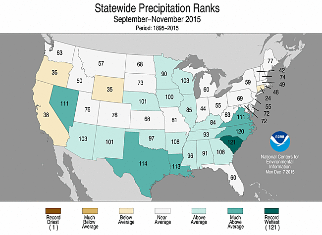
- The September-November contiguous U.S. average temperature was record warm at 56.8°F, 3.3°F above the 20th century average. This surpassed the previous record warm autumn of 1963 which had a temperature of 56.6°F.
- Every state across the contiguous U.S. and Alaska had an above-average autumn temperature. Forty-one states across the Rockies, Great Plains, Midwest, Northeast, and Southeast were much warmer than average. Florida tied its warmest autumn on record with a statewide temperature of 75.5°F, 3.6°F above average.
- The autumn contiguous U.S. maximum (daytime) temperature was 68.6°F, 2.8°F above the 20th century average, the fourth warmest on record and warmest since 1999. Much-above average maximum temperatures were observed across the northern half of the nation. Connecticut, Massachusetts, New Hampshire, and Rhode Island had a record warm autumn maximum temperature.
- The autumn minimum (nighttime) temperature was 45.1°F, 3.7°F above average, the warmest on record. This bested the previous record set in 1998 by 0.3°F. Every state in the contiguous U.S., except Oregon and Washington, had an autumn minimum temperature that was much above average. Colorado, Florida, New Mexico, North Dakota, Nebraska, and Minnesota each had an autumn minimum temperature that was record warm.
- Based on NOAA's Residential Energy Demand Temperature Index (REDTI), the contiguous U.S. temperature-related energy demand during September-November was 56.7 percent below average and the ninth lowest in the 1895-2015 period of record.

January-November 2015 Statewide Temperature and Precipitation ranks
Precipitation
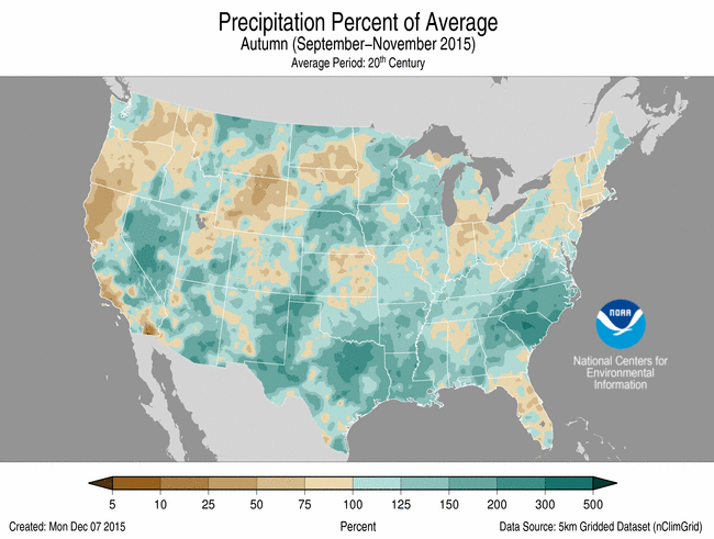
- The autumn precipitation total for the contiguous U.S. was 8.32 inches, 1.44 inches above the 20th century average. This was the 15th wettest September-November on record for the Lower 48 and the wettest since 2004.
- Above-average autumn precipitation was observed across parts of the West, Southern Plains, and Southeast. Louisiana, Nevada, North Carolina, South Carolina, and Virginia were each much wetter than average.
- South Carolina** had its wettest autumn on record, partially driven by historic rainfall in early October. South Carolina's autumn precipitation total was 23.62 inches, 13.77 inches above average, and bested the previous record of 18.42 inches set in 1959.
- Below-average autumn precipitation was observed along the West Coast and New England. California, Connecticut, Oregon, and Wyoming were each drier than average for the three-month period.
- Alaska had its sixth wettest autumn with 15.76 inches of precipitation, 3.41 inches above average.
Extremes
- The U.S. Climate Extremes Index (USCEI) for autumn was 50 percent above average and the 10th highest value on record. On the national scale, extremes in warm maximum and minimum temperatures and one-day precipitation totals were much above average. The USCEI is an index that tracks extremes (falling in the upper or lower 10 percent of the record) in temperature, precipitation, land-falling tropical cyclones, and drought across the contiguous U.S.
- On the regional scale, the CEI for the Northeast, Upper Midwest, South, and Northwest were each much above average.
- Climate Highlights — November
Temperature
- The November contiguous U.S. temperature was 44.7°F, 3.0°F above the 20th century average and the 13th warmest in the 121-year period of record.
- Above-average November temperatures were widespread across the eastern half of the nation, where 32 states were much warmer than average. New Jersey had its warmest November on record with a statewide temperature of 49.7°F, 6.6°F above average.
- Below-average temperatures were observed across the West where Arizona, California, Idaho, Nevada, Oregon, and Utah were each cooler than average.
- The November contiguous U.S. maximum temperature was 55.3°F, 2.6°F above the 20th century average, the 20th warmest on record. Much-above average maximum temperatures were observed in the Midwest and Northeast and Florida. Florida had its warmest November maximum temperature on record at 81.1°F, 5.9°F above average, surpassing the previous record set in 1986 by 0.2°F. Below-average maximum temperatures were observed in the West.
- The November contiguous U.S. minimum temperature was 34.0°F, 3.3°F above average and the eighth warmest on record. Much-above average minimum temperatures were widespread across the eastern half of the nation, while below-average minimum temperatures were observed in the West.
- Based on REDTI, the contiguous U.S. temperature-related energy demand during November was 68.0 percent below average and the fourth lowest in the 1895-2015 period of record.
- During November, there were 4,502 record warm daily high (1,642) and low (2,860) temperature records, which is five times the 866 record cold daily high (494) and low (372) temperature records.

November 2015 Statewide Temperature and Precipitation ranks
Precipitation
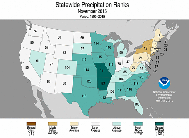
- The November precipitation total was the fourth wettest on record with 3.30 inches, 1.07 inches above average.
- Above-average November precipitation was observed across much of the Great Plains, Midwest, and Southeast. Eleven states were much wetter than average in these regions. Arkansas and Missouri were record wet. The Arkansas precipitation total was 10.65 inches, 6.36 inches above average. The Missouri precipitation total was 7.86 inches, 4.95 inches above average.
- Below-average precipitation fell across the Northeast. New York and Vermont were much drier than average.
- Alaska had its fifth wettest November on record with a statewide precipitation total of 5.39 inches, 2.0 inches above average.
- According to the December 1st U.S. Drought Monitor report, 20.6 percent of the contiguous U.S. was in drought, down about 5.6 percent compared to the beginning of November. Drought conditions improved across parts of the Southern Plains and the Mid- to Lower Mississippi River Valley. Drought conditions also improved greatly across western Washington where an earnest start to the wet season brought much needed precipitation. Drought continues to plague interior regions of the Northwest and much of California and Nevada.
- Climate Highlights — year-to-date (January–November)
Temperature
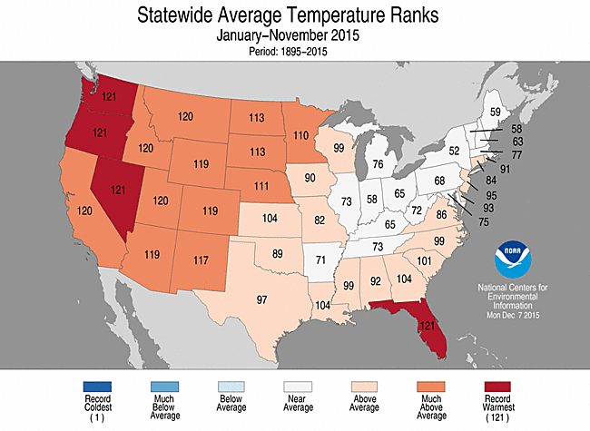
- The year-to-date contiguous U.S average temperature was 55.8°F, 2.1°F above average, the fifth warmest on record. This was the warmest year-to-date since 2012.
- Above-average temperatures were observed in the West, Northern Plains, and Southeast. Overall, 17 states, including Alaska, were much warmer than average. Florida, Nevada, Oregon, and Washington were each record warm. Near-average temperatures were observed in the Midwest and Northeast.
- Alaska had its second warmest year-to-date on record with a statewide average temperature of 32.0°F, 4.0°F above average. Only January-November 1926 was warmer for the state with a temperature of 32.4°F.
- The January-November contiguous U.S. maximum temperature was 67.7°F, 1.8°F above the 20th century average, the ninth warmest on record. Much-above average maximum temperatures were observed in the West and Florida. Oregon and Washington had their warmest year-to-date maximum temperature on record, 4.8°F and 4.3°F above average, respectively. Near-average maximum temperatures were widespread across the East.
- The January-November contiguous U.S. minimum temperature was 44.0°F, 2.3°F above the 20th century average, the third warmest on record. Much-above average minimum temperatures were observed in the West, South, and Southeast. In total, 11 states had their warmest year-to-date minimum temperature on record. Near and below-average minimum temperatures were observed in the Midwest and Northeast.
- Based on REDTI, the contiguous U.S. temperature-related energy demand during January-November was 4.5 percent below average and the 52nd lowest in the 1895-2015 period of record.
January-November 2015 Statewide Temperature and Precipitation ranks
Precipitation
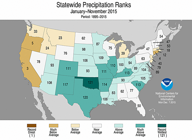
- The year-to-date precipitation total for the contiguous U.S. was 30.48 inches, 2.89 inches above average, and the ninth wettest on record. Above-average precipitation was observed across the central and southeastern U.S., where nine states were much wetter than average. Oklahoma had its wettest year-to-date with 48.00 inches of precipitation, 15.89 inches above average, besting the previous record of 47.12 inches set in 1908.
- Below-average precipitation was observed across the West and Northeast. California had the third driest January-November, Connecticut the fourth driest, and Oregon the fifth driest.
Extremes
- The USCEI for the year-to-date was 45 percent above average and the 12th highest value on record. On the national scale, extremes in warm maximum and minimum temperatures, one-day precipitation totals, and days with rain were much above average.
- Regionally, the Northwest, Southwest, and West had a year-to-date CEI that was much above average.
**Our October precipitation analyses for South Carolina and Texas have been revised. Daily precipitation totals at the Charleston, South Carolina and Austin, Texas airports were excluded from the monthly analysis. The October 3rd precipitation total of 11.50 inches at Charleston and the October 29th precipitation of 13.00 inches at Austin were not included in the provisional monthly totals, resulting in erroneously small monthly precipitation totals at those locations. The revised monthly totals at these stations raised the resultant statewide precipitation totals for both South Carolina and Texas. The corrected October South Carolina precipitation total is 12.17 inches, up from the 10.36 inches reported last month. The 12.17 inches in South Carolina is a new record high total for the month of October. The corrected October Texas precipitation total is 6.17 inches, up from the 5.84 inches reported last month. The 6.17 inches in Texas tied 2002 as the second most for October. The most up-to-date data and analyses are available through our Climate at a Glance tool.**
**A comparison of the national temperature departure from average as calculated by NCDC's operational dataset (nClimDiv), the U.S. Historical Climatology Network (USHCN), and the U.S. Climate Reference Network (USCRN) is available on our National Temperature Index page.**
Regional Highlights:
These regional summaries were provided by the six Regional Climate Centers and reflect conditions in their respective regions. These six regions differ spatially from the nine climatic regions of the National Climatic Data Center.
- Northeast Region: (Information provided by the Northeast Regional Climate Center)
- November 2015 was the warmest November on record for the Northeast. The region's average temperature of 44.4 degrees F (6.9 degrees C) was 5.0 degrees F (2.8 degrees C) above normal. New York, New Jersey, and Connecticut were all record-warm. The other nine states ranked this November among their top five warmest: second warmest in Vermont, Pennsylvania, New Hampshire and Delaware; third warmest in Massachusetts; fourth warmest in West Virginia, Rhode Island, and Maine; and fifth warmest in Maryland. State departures ranged from 4.1 degrees F (2.3 degrees C) above normal in Delaware to 5.8 degrees F (3.2 degrees C) above normal in New York. Three of the region's major airport climate sites were record-warm for the month: Newark, NJ; Central Park, NY; and Islip, NY. With a mild September, a near-normal October, and a very warm November, the autumn season also averaged out to be warmer than normal. With an average temperature of 53.0 degrees F (11.7 degrees C), 3.2 degrees F (1.8 degrees C) above normal, the Northeast had its second warmest autumn on record. Seven states also had their second warmest autumn: New York, Connecticut, Vermont, New Jersey, Pennsylvania, Massachusetts, and Rhode Island. New Hampshire and Maine had their third warmest autumn. West Virginia saw its fifth warmest autumn, followed by Delaware with its sixth warmest and Maryland with its seventh warmest. Average temperatures ranged from 2.3 degrees F (1.3 degrees C) above normal in Maryland to 3.6 degrees F (2.0 degrees C) above normal in New York. Five airport climate sites experienced a record-warm autumn: Central Park, NY; Newark, NJ; Islip, NY; Kennedy Airport, NY; and LaGuardia Airport, NY.
- The Northeast had its 16th driest November on record. The region received 2.15 inches (54.61 mm) of precipitation, which was 56 percent of normal. All states saw below-normal precipitation, ranging from 43 percent of normal in Connecticut to 95 percent of normal in Delaware. Six states ranked the month among their top 20 driest Novembers: ninth driest in Vermont; 12th driest in New York; 14th driest in Connecticut; 15th driest in Maine; and 20th driest in Massachusetts and New Hampshire. The month's warm conditions contributed to below-normal snowfall for most of the region. Autumn was also drier than normal. The region picked up 10.43 inches (264.92 mm) of precipitation, or 89 percent of normal. All states saw below-normal precipitation, from 66 percent of normal in Connecticut to 96 percent of normal in Maine.
- The November 5 U.S. Drought Monitor showed that 17 percent of the Northeast was abnormally dry, while another 6 percent of the region was experiencing moderate drought. With below-normal precipitation during the month, abnormally dry conditions increased in coverage slightly. By month's end, 22 percent of the region was abnormally dry while the area experiencing moderate drought remained at 6 percent.
- For more information, please go to the Northeast Regional Climate Center Home Page.
- Midwest Region: (Information provided by the Midwest Regional Climate Center)
- November temperatures were well above normal in the Midwest. Temperatures were more than 5 degrees F (3 C) above normal for the region, ranking as the fifth warmest on record (1895-2015). Statewide departures ranged from about 4 degrees F (2 C) in the southern states to nearly 8 degrees F (4 C) above normal in the northern states with all nine states ranking in the top ten percent of their respective histories. The fall, combining the very warm September and November with the slightly above average October, also came in among the warmest on record. The seasonal departure for the Midwest was 4 degrees F (2 C) above normal, ranking it as the second warmest on record and the warmest in over 50 years. Statewide values for the fall season also ranked in the warmest ten percent of the record in all nine states with the northern states of Minnesota, Wisconsin, and Michigan all ranking as their second warmest fall. The record warmest fall for the region, and all states except Minnesota, remains the fall season of 1931.
- November precipitation was very heavy in the western half of the region but dropped below normal to the east. Monthly totals exceeded 12 inches (305 mm) in southeastern Missouri helping to bring the Missouri statewide rainfall total to 7.86 inches (200 mm) which ranked it as the wettest November on record. Illinois, Iowa, Minnesota, and Wisconsin also ranked in the wettest 10 percent while Ohio was well below average, with a statewide deficit of over 1 inch (25 mm). Many stations in Missouri and Iowa set new records for November rainfall. Heavy snow fell from Iowa to the southern half of Lake Michigan in the week before Thanksgiving, for monthly totals that topped normal by 5 to 10 inches (13 to 25 cm). Further to the north, snowfall totals were below normal for the month. Fall precipitation was closer to normal in most of the Midwest with a few locations below 75 percent of normal and a few more with 125 percent of normal. Dry weather in September and October in Missouri offset the very wet conditions in November.
- Drought eased in the region during November, particularly in the western half of the region. The November rains were cause for removing drought completely from Missouri, Kentucky, Iowa, Minnesota, and Wisconsin and nearly so in Illinois, where the only remaining drought was in the counties bordering Indiana in the southeast part of the state. Some remaining areas of drought persisted in Indiana and Michigan but the areal coverage of drought in the Midwest dropped from 16 percent of the region to less than 4 percent by the end of the month.
- Freezing conditions touched the remaining areas of the region which had not yet received a freeze. Scattered stations across the southern half of the region had yet to receive a 32 degree F (0 C) freeze at the start of November and scattered stations in all nine states had yet to get a hard freeze of 28 degrees F (-2 C).
- Minor flooding was reported on the Mississippi and Missouri rivers, and their tributaries, in late November due to the heavy rains in Missouri and neighboring states.
- The storm that brought heavy snow to Iowa, northern Illinois, southern Wisconsin, northwest Indiana, and southwest Michigan on November 11th through 13th also brought extremely windy conditions and severe weather to the Midwest. Thirteen tornadoes were reported in Iowa, including one at the Des Moines airport and strong thunderstorms caused wind damage in Iowa and northwest Illinois. Straight line winds associated with the storm system also caused transportation problems, particularly in Chicago where hundreds of flights were delayed at the two major airports and the Chicago Skyway Bridge was closed for 12 hours. Widespread winds of 40-55 miles per hour (64-89 km per hour) occurred across large parts of Illinois and Wisconsin and winds of 60-70 miles per hour (97-113 km per hour) were reported in the Chicago area.
- For further details on the weather and climate events in the Midwest, see the weekly and monthly reports at the Midwest Climate Watch page.
- Southeast Region: (Information provided by the Southeast Regional Climate Center)
- Temperatures were above average across much of the Southeast region, with numerous extremes recorded during November. The greatest departures were found across Alabama, Florida, southern Georgia, and western Virginia, where monthly temperatures were 5 to 9 degrees F (2.8 to 5 degrees C) above average. Twelve long-term (period of record exceeding 50 years) stations observed their warmest November mean temperature on record, including Huntsville, AL (1907-2015), Tallahassee, FL (1893-2015), and Daytona Beach, FL (1923-2015). Florida was particularly warm during the month, as fifteen long-term stations observed their third warmest or higher mean temperature for November on record. Mean temperatures were slightly above average in Puerto Rico and the U.S. Virgin Islands, as Juncos, PR (1931-2015) tied its third warmest November mean temperature on record. The warmest weather of the month occurred from the 4th through the 7th, as moist tropical air surged northward ahead of an approaching cold front. During this four-day period, maximum temperatures exceeded 70 degrees F (21.1 degrees C) across much of the region, with some locations reaching the upper 80s F (30.6 to 31.7 degrees C) and lower 90s F (32.2 to 33.9 degrees C). On the 4th, Tampa, FL (1890-2015) and Tallahassee, FL recorded their warmest maximum temperature for November at 92 (33.3 degrees C) and 89 degrees F (31.7 degrees C), respectively. On the 6th, Montgomery, AL (1872-2015) observed its warmest maximum temperature for November at 88 degrees F (31.1 degrees C). In contrast, the coolest weather of the month occurred from the 23rd through the 24th, as a Canadian high settled over the region. Daily minimum temperatures fell below 40 degrees F (4.4 degrees C) across all states within the region, with many locations reaching the lower-to-middle 20s F (-6.1 to -3.3 degrees C).
- Precipitation was above normal across much of the Southeast region during November, with several extremes recorded during the month. The driest locations were found across portions of northern and central Florida, where monthly precipitation totals were between 25 and 50 percent of normal. In contrast, the wettest locations were found across northern Florida, southeastern Alabama, Georgia, the Carolinas, and southwestern Virginia, where monthly precipitation totals were 150 to 300 percent of normal. At least 1 long-term station in every state across the region observed its wettest or second wettest November on record. Thirteen long-term stations in North Carolina observed their greatest or second greatest precipitation total for November on record. Asheville, NC (1869-2015), Charlotte, NC (1878-2015), and Charleston, SC (1938-2015) observed their wettest November on record with 7.82 (199 mm), 10.04 (255 mm), and 8.30 inches (211 mm) of precipitation, respectively. Athens, GA (1884-2015) and Greenville-Spartanburg, SC (1889-2015) recorded their second and third wettest November with 9.30 (236 mm) and 9.13 inches (232 mm) of precipitation, respectively. On the 8th, Mayport, FL (1959-2015), located about 15 miles northeast of Jacksonville, observed its all-time wettest day on record with 11.70 inches (297 mm) of precipitation. On the 18th, Huntsville, AL (1894-2015) observed its second wettest November day on record with 3.87 inches (98 mm) of precipitation. Precipitation was highly variable across Puerto Rico and the U.S. Virgin Islands, with above-average (below-average) rainfall over northern and western (southern and eastern) portions of the region.
- There were only 35 severe weather reports across the Southeast during November, which is less than 50 percent of the median monthly frequency of 76 reports during 2000-2014. Approximately 70 percent of these reports were for damaging thunderstorm winds, which is typical for late autumn. At least one severe weather report was recorded within the region on only 4 days during the month. Thirteen tornadoes (8 EF-0s, 5 EF-1s) were confirmed across the region during the month, which is slightly above the short-term (2000-2014) median frequency of 10 tornadoes observed during November. All thirteen tornadoes occurred in Georgia and Florida, where moist unstable air lifted into an active subtropical jet stream. On the 2nd, an EF-1 tornado damaged two large irrigation systems near Lumber City, GA. An EF-1 tornado touched down near Fairburn, GA on the 18th, causing damage to numerous homes and the football field at a local high school. In addition, one minor injury occurred when a tree fell on a person's vehicle. On the same day, a man in Paulding County, GA was injured after lightning struck a nearby power line and dispersed its charge into the ground.
- Drought conditions were completely ameliorated across the Southeast region (excluding Puerto Rico) during November. The percentage of the region under drought-free conditions (less than D1) increased from 98 percent on November 3rd to nearly 100 percent on December 1st. Beneficial rainfall during the month eliminated pockets of moderate (D1) drought across west-central Alabama, southern Georgia, and the Florida Panhandle. The extent of severe-to-extreme (D2 and D3) drought conditions across eastern Puerto Rico decreased about 9 percent during the month, reaching a coverage of 16 percent on December 1st. Unusually warm and wet conditions reduced the quality and delayed the harvest of numerous agricultural crops across the region. Premature sprouting (i.e. germination of the seed while still on the tree) was reported in many Georgia pecan orchards, and the harvest of cotton, peanuts, and soybeans across the Carolinas was poor due to saturated fields. Late in the month, windy conditions in Palm Beach County, FL twisted off the young seedlings of many vegetable plants, including tomatoes, peppers, and eggplant.
- For more information, please go to the Southeast Regional Climate Center Home Page.
- High Plains Region: (Information provided by the High Plains Regional Climate Center )
- The climate summaries over the past few months have started to sound like a broken record as the big story this month was, again, the extreme warmth for much of the High Plains region. In fact, the whole eastern half of the country had temperatures that were well above normal with widespread temperature departures of at least 4.0 degrees F (2.2 degrees C) above normal. The largest departures occurred in the north-central U.S. and Florida where departures were in excess of 6.0 degrees F (3.3 degrees C) above normal. Much of the West, however, experienced temperatures that were on the cooler side, with widespread departures of 2.0-4.0 degrees F (1.1-2.2 degrees C) below normal. The warmth this month was just a continuation of conditions that have occurred throughout the fall. Every station in the region came in at above normal for the season, with the majority of locations in excess of 4.0 degrees F (2.2 degrees C) above normal. Stations all across the region ranked in the top 5 warmest falls on record, with a small sampling including Norfolk, NE (warmest), Colorado Springs, CO (2nd), Fargo, ND (2nd), Wichita, Kansas (2nd), Huron, SD (2nd), and Cheyenne, WY (3rd). The warmth this fall aided in crop dry down and harvesting activities and also led to many late hard freezes. A quick look at the outlooks shows that this warmth is likely to continue through the winter, with the highest probability of above-normal temperatures located in the northern tier of the region. Although the warm weather was the headline this month, it was not quiet in terms of precipitation. Large areas of the country received at least 200 percent of normal precipitation, including areas of the central and southern Plains, the Midwest, and Southeast. Although seemingly impressive, as much of the High Plains region enters the driest time of the year, these totals were not large enough to overcome some of the deficits that accumulated earlier in the fall in places like eastern Kansas. But, the precipitation that fell this month was able to help recharge soil moisture in some areas, like Nebraska, because the ground had not frozen just yet.
- It was another warm month for the High Plains region as much of Kansas, Nebraska, South Dakota, and North Dakota had monthly temperature departures in excess of 4.0 degrees F (2.2 degrees C) above normal. The largest departures occurred in the eastern Dakotas where departures of 6.0-8.0 degrees F (3.3-4.4 degrees C) above normal were common. As a result, many locations ranked in the top 10 warmest Novembers on record including Fargo, ND (5th), Lincoln, NE (8th), Aberdeen, SD (8th), and Concordia, KS (10th). Other areas of the region were generally within 2.0 degrees F (1.1 degrees C) above or below normal. As mentioned earlier, the warm weather this month and fall led to late hard freezes for some locations. These late freezes had varied impacts across the region. A negative impact was a delay in the killing of insects; however, a positive impact was an extended growing season this fall for gardens, flowers, and trees. This allowed gardeners to continue to harvest herbs and vegetables, such as tomatoes and peppers, well into November. Flowers were also blooming until very late in the season. For instance, daylilies were spotted in the Lincoln, Nebraska area as late as November 15th. Trees also retained their leaves and stayed green until late in the season in many areas.
- There were both wet areas and dry areas this month across the High Plains region. Large areas picked up precipitation totals in excess of 150 percent of normal including Kansas, most of Nebraska, southeastern South Dakota, eastern North Dakota, west-central and southeastern Wyoming, and the eastern and western sides of Colorado. Embedded within this area were swaths where precipitation totals ranged from 200-400 percent of normal. This did not translate into tremendous precipitation amounts because the region is entering the driest portion of the year; however, there were some areas of Kansas and Nebraska that had surpluses in the 1.50-3.00 inch (38-76 mm) range. Although there was widespread precipitation this month for much of the region, there were some dry areas including northeastern Wyoming, northwestern South Dakota, and much of western and central North Dakota. These areas received, at best, 50 percent of normal precipitation. Fortunately, at this time of the year, deficits do not add up quickly. In areas receiving at least 200 percent of normal precipitation, many locations ranked in the top 10 wettest or snowiest Novembers on record. Ranking in the top 10 wettest were Sioux Falls, SD (2nd), Denver, CO (4th), Topeka, KS (7th), Valentine, NE (7th), Wichita, KS (7th), and Grand Island, NE (8th). A closer look at Sioux Falls, South Dakota revealed that it received 3.89 inches (99 mm) of liquid equivalent precipitation this month, which was 286 percent of normal. (Liquid equivalent precipitation is the total amount of rain that fell, plus any melted snow, sleet, or ice accumulations.) Additionally, Sioux Falls had its 4th snowiest November on record with 17.3 inches (44 cm) - 8.7 inches (22 cm) of which fell on the last day of the month. Interestingly, this daily total came in as the 4th snowiest November day on record for Sioux Falls (period of record 1893-2015). The same system that brought the heavy snow to Sioux Falls at the end of the month was just one portion of a stalled out system that brought heavy precipitation in the form of rain, freezing rain, sleet, and snow to large area of the Plains. Central and eastern Kansas was hit particularly hard with several rounds of freezing rain, starting on Thanksgiving Day. Several days of freezing rain and drizzle resulted in ice accumulations exceeding 0.75 inch (2 cm). According to the National Weather Service Offices of Topeka and Wichita, this led to widespread power outages due to downed power lines and trees.
- There were only minor changes to the U.S. Drought Monitor over the past month. Although there were slight improvements and degradations in moderate drought conditions (D1) throughout the month, there was a net decline of about a half a percent. This is reflected in the total area in drought (D1-D4) of the region, which decreased just slightly from about 4 percent to just under 3.5 percent. Abnormally dry conditions (D0) dropped about 4 percent to 32 percent in coverage as well. Above normal rainfall helped eliminate some of the D0, which had emerged over the past couple of months including some areas of Nebraska, Kansas, and Colorado. On the drier end of the spectrum, an area stretching from northeastern Wyoming through northwestern South Dakota and into central North Dakota had precipitation totals that were less than 50 percent of normal. Luckily, as the region moves into the drier part of the year, this did not translate into large deficits. Some D0 expanded within this area because of ongoing dryness; however, no new drought conditions developed. Drought conditions could improve by the next climate summary because of heavy precipitation in the form of rain, freezing rain, and sleet during the last week of the month. November 24th was the cutoff date for the latest release of the U.S. Drought Monitor, so this precipitation will be reflected in the first release of December. Anywhere from 2.00-4.00 inches (51-102 mm) of liquid equivalent precipitation fell across eastern Kansas, so drought conditions could improve there.
- For more information, please go to the High Plains Regional Climate Center Home Page.
- Southern Region: (Information provided by the Southern Regional Climate Center)
- There were only minor changes to the U.S. Drought Monitor over the past month. Although there were slight improvements and degradations in moderate drought conditions (D1) throughout the month, there was a net decline of about a half a percent. This is reflected in the total area in drought (D1-D4) of the region, which decreased just slightly from about 4 percent to just under 3.5 percent. Abnormally dry conditions (D0) dropped about 4 percent to 32 percent in coverage as well. Above normal rainfall helped eliminate some of the D0, which had emerged over the past couple of months including some areas of Nebraska, Kansas, and Colorado. On the drier end of the spectrum, an area stretching from northeastern Wyoming through northwestern South Dakota and into central North Dakota had precipitation totals that were less than 50 percent of normal. Luckily, as the region moves into the drier part of the year, this did not translate into large deficits. Some D0 expanded within this area because of ongoing dryness; however, no new drought conditions developed. Drought conditions could improve by the next climate summary because of heavy precipitation in the form of rain, freezing rain, and sleet during the last week of the month. November 24th was the cutoff date for the latest release of the U.S. Drought Monitor, so this precipitation will be reflected in the first release of December. Anywhere from 2.00-4.00 inches (51-102 mm) of liquid equivalent precipitation fell across eastern Kansas, so drought conditions could improve there.
- November was an extremely wet month for the Southern Region, with the majority of stations averaging 150 to 200 percent of normal precipitation. For the entire Southern Region, it was the fourth wettest November on record (1895-2015). Only a small portion of the region experienced a drier than normal month. This included a small handful of counties in southern Texas and in the western Texas panhandle. A large area of the region averaged over 200 percent of normal precipitation. This included most of Arkansas, eastern Oklahoma and central Texas. The state-wide precipitation totals for the month are as follows: Arkansas reporting 10.65 inches (270.51 mm), Louisiana reporting 8.82 inches (224.03 mm), Mississippi reporting 7.18 inches (182.37 mm), Oklahoma reporting 5.91 inches (150.11 mm), Tennessee reporting 6.34 inches (161.04 mm), and Texas reporting 3.85 inches (97.79 mm). It was the wettest November on record for Arkansas, and the second wettest November on record for Oklahoma. Texas experienced their sixth wettest November, while for Louisiana, it was their ninth wettest. Mississippi recorded their sixteenth wettest November while Tennessee reported their eighteenth wettest November. All state ranking records are based on the period spanning 1895-2015.
- Heavy precipitation throughout the Southern Region has led to the complete removal of drought conditions such that all 6 states are now drought-free. Only small pockets of abnormally dry conditions remain in parts of Texas and Oklahoma.
- On November 16, the passage of a cold front resulted in over a dozen tornadoes in eastern Oklahoma and northern Texas. There were no reports of fatalities or injuries. Damage was mainly limited to trees and power lines.
- On November 17, the cold front which unleashed havoc in Texas and Oklahoma a day earlier, spawned thunderstorms with numerous tornadoes in central Mississippi. Most of the reported damage was limited to trees and power lines and there were no reports of injuries or fatalities.
- In Texas Heavy rains were untimely for most farmers as it coincided with harvest time for farmers across the state. While crops were still able to be harvested, farmers saw a decrease in crop yield due to stagnant water on their crops, which can easily spread diseases. Some cotton farmers are expecting half of their estimated yields. However, some citrus farmers in southern Texas are enjoying a $5 increase in prices across all categories due to high off season rains. Although the rains did not necessarily help farmers, hunters will be pleased with it. Despite the record rain so far in 2015, the hunting season is expected to be one of the best in years, expected to have an economic impact greater than 2011's $3.65 billion. Population numbers for each animal is at a high point over the past few years (Information provided by the Texas Office of State Climatology).
- The States at Risk Project included Texas in the top five states that are at the most risk of changing weather due to climate change. Texas also received poor grades for preparedness of climate change, which is not good news due to the fact Texas will most likely see the most extreme changes in weather because of a shift in the climate. For the fourth year in a row, Texas has seen a rise in vehicle injuries and fatalities. While the most likely cause is an increase in speed limits on highways, weather related accidents have also increased (Information provided by the Texas Office of State Climatology).
- For more information, please go to the Southern Regional Climate Center Home Page.
- Western Region: (Information provided by the Western Region Climate Center)
- Several low-pressure systems crossed the West this month bringing scattered areas of above normal precipitation and cooler than normal temperatures to the region. The first significant snowfalls of the season were observed in the Sierra Nevada, Cascades, and Rocky Mountains, allowing winter snowpack to begin accumulating.
- Following widespread above normal temperatures in October, November was cooler than normal for most of the West. In southeastern Oregon, Burns reported an average 27.4 F (-2.5 C), 5.9 F (3.2 C) below normal, the 4th coolest November since records began in 1973. To the northeast in Montana, average November temperature in Butte was 21.5 F (-5.8 C), 6.2 F (3.4 C) below normal and 8th coolest in a 122-year record. Both Burns and Butte saw average temperatures more than 20 F (11 C) below normal during a sharp cold spell over the West. To the south, Pahrump, Nevada, was cooler than normal with an average 46.8 F (8.2 C), 5 F (2.7 C) below normal and 8th coldest November since records began in 1914. Reno, Nevada observed its latest freeze on record, with temperatures remaining above 32 F (0 C) until November 4. The previous record for latest freeze was November 3, 1992. Further south, coastal areas of southern California saw above normal temperatures. In San Diego, average November temperature was 63.6 F (17.5 C), 2.3 F (1.2 C) above normal. Temperatures east of the Rockies were near to above normal.
- Precipitation was variable across the West, with scattered areas receiving well above normal precipitation. A storm Nov 1-3 brought heavy precipitation to central California. Monterey recorded 1.7 in (43 mm) on the 2nd and a monthly total of 3.92 in (100 mm), 209% of normal and the 3rd wettest November since records began in 1968. Precipitation was able to spill over into the western Great Basin. Reno, Nevada, observed 1.04 in (26 mm) of rain on November 2. Reno airport totaled 2.1 in (53 mm) for the month, 256% of normal, the 3rd wettest since records began in 1937. Both latter cities noted their 3rd wettest November day on the 2nd. Snow water equivalent (SWE) was variable along the length of the Sierra Nevada, though generally above 75% of normal. Precipitation totals were near to slightly below normal throughout the range. In the Pacific Northwest, Seattle recorded 8.37 in (213 mm) this month, 127% of normal. November facilitated removal of drought conditions throughout western Washington. Values of SWE over 90% of normal only occurred in the far northern Cascades and the Olympic Mountains. SWE in the central and southern Cascades was generally were near or below 60% of normal SWE along with below normal precipitation. In the Great Basin, nearly all ranges reported SWE values above 200% of normal. Further east, western Montana and the northern Rockies observed above normal precipitation. Dillon, Montana recorded its 3rd wettest November on record at 1.04 in (26 mm), 280% of normal. Denver observed 2.13 in (54 mm), 349% of normal precipitation. Despite areas of above normal precipitation, SWE was generally below 75% of normal in the northern and central Rockies. Towards the southern extent of the Rockies, SWE values transitioned into the above normal range. Note that in most cases climatological values are low, so large percentages are common.
- Some areas were quite dry this month. Much of southwestern Oregon and northern California observed less than 75% of normal November precipitation. In far northern California, Montague received only 0.38 in (10 mm), 13% of normal, the second driest November since records began in 1948. Southern California and western Arizona also saw below normal precipitation; Los Angeles recorded only 0.01 in (<1 mm) for the month, 1.03 in (26 mm) below normal. Little or no November rainfall is not uncommon for this area; 23 other years in Los Angeles's 139-year record saw 0.01 in (<1 mm) or less.
- The above normal temperatures observed in Hawaii over the past four months continued into November. Most locations saw departures of more than 2.4 F (1.3 C) above normal for the month. Lihue, Kauai (78.6 F/25.8 C), as well as Hilo (76.9 F/24.9 C) and Kona (80.4/26.8 C) on the Big Island all observed their warmest Novembers in 65+ year records. Conditions were also wetter than normal across much of the state. Kahului, Maui recorded 4.42 in (112 mm) of rainfall, 200% of normal and Hilo reported 22.81 in (579 mm), 147% of normal. To the north, conditions were also wetter and warmer than normal for much of Alaska. Some of the greatest departures from normal temperature were observed in the interior part of the state, where McGrath recorded an average temperature of 16 F (-8.8 C), 10.4 F (5.7 C) above normal and the 6th warmest November since records began in 1941. The greatest precipitation anomalies were also seen in the Interior; Fairbanks recorded 1.78 in (45 mm) precipitation for the month, 266% of normal and the 5th wettest November since records began in 1929.
- November 17th: Powerful windstorm in Pacific Northwest: Areas east of the Cascades in the Pacific Northwest experienced very high winds ahead of a cold front. Spokane, Washington reported a gust of 71 mph (114 kph) and mountain passes in the region observed gusts over 100 mph (160 kph). At least two deaths were reported due to falling trees and hundreds of thousands were without power, some for several days.
- For more information, please go to the Western Regional Climate Center Home Page.