National Overview:

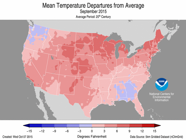 September Average Temperature Departures |
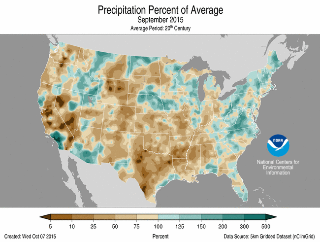 September Percent of Average Precipitation |
- Climate Highlights — September
Temperature
- The September contiguous U.S. average temperature was 68.5°F, 3.7°F above the 20th century average and the second warmest on record. Only September 1998 was warmer for the Lower 48 with a monthly average temperature of 69.0°F.
- Record and near-record warmth was observed across most of the country. Thirty states had September temperatures that were much above average and nine states — Connecticut, Colorado, Maine, Michigan, Minnesota, New Mexico, Rhode Island, Utah, and Wisconsin — were record warm.
- Near-average September temperatures were observed in the Southeast and in the Northwest. The near-average temperatures in the Northwest were a reprieve from the record warm summer (June-August) and aided firefighters battling the record-breaking wildfires in the region.
- Alaska had its 19th coolest September with a statewide average temperature of 38.8°F, 1.8°F below average.
- The September contiguous U.S. maximum (daytime) temperature was 81.3°F, 3.5°F above average, the fourth warmest on record. Record warm maximum temperatures were observed in the Central Rockies and New England. Colorado, Wyoming, Maine, Connecticut, Massachusetts, and Rhode Island each had record warm maximum temperatures.
- The September contiguous U.S. minimum (nighttime) temperature was 55.8°F, 3.9°F above average, the second warmest on record. Only September 1998 had warmer minimum temperatures for the Lower 48. Record warm minimum temperatures were observed in the Northern Plains and Upper Midwest. Nebraska, South Dakota, Minnesota, Wisconsin, and Michigan each had record warm minimum temperatures.
- During September, there were 4,506 record warm daily high (1,611) and low (2,895) temperature records, which is about five and a half times the 802 record cold daily high (461) and low (341) temperature records.
- Based on NOAA's Residential Energy Demand Temperature Index (REDTI), the contiguous U.S. temperature-related energy demand during September was 80.2 percent above average and the ninth highest in the 1895-2015 period of record.
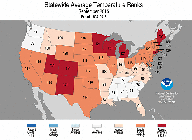
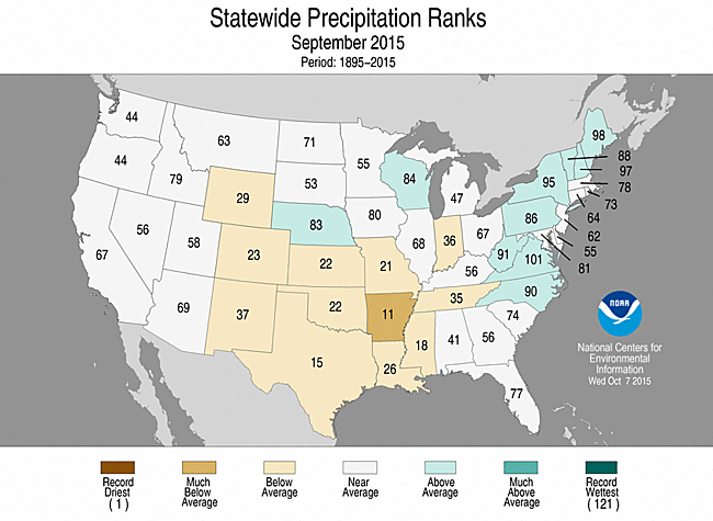
September 2015 Statewide Temperature and Precipitation ranks
Precipitation
- The September precipitation total for the contiguous U.S. was 2.09 inches, 0.40 inch below average and the 21st driest on record.
- Above-average precipitation was observed for parts of the Midwest, Mid-Atlantic, and Northeast. Below-average precipitation was observed across the Central Rockies, Southern Plains, and the Lower Mississippi River Valley. Arkansas had its 11th driest September on record.
- The remnants of Hurricane Linda in the northeast Pacific Ocean interacted with an upper level low pressure system bringing heavy precipitation to the Southwest on September 14th and 15th. Los Angeles had its third wettest September on record with 2.39 inches of rainfall, all of which fell on the 15th, 2.15 inches above the monthly average. Flash flooding was observed in southern Utah which killed 13 people in Hildale and another seven in nearby Zion National Park.
- Interior and southern Alaska were wetter than average, with Anchorage and Fairbanks observing their wettest September on record with precipitation totals of 7.71 inches and 3.74 inches, respectively. The normal September precipitation is 1.1 inches in Fairbanks and 2.99 inches in Anchorage. Early-season snowfall was also observed in Anchorage and Fairbanks at mid-month, marking the earliest snowfall in over 20 years for those locations. As a whole, Alaska had its 11th wettest September on record with 5.92 inches of precipitation, 1.35 inches above average.
- Record and near-record precipitation was observed across Hawaii. Honolulu observed 4.48 inches of precipitation, surpassing the previous September record set in 1947 by 2.08 inches. The normal September precipitation for Honolulu is 0.70 inch. This was the second consecutive record wet month for Honolulu.
- According to the September 29th U.S. Drought Monitor report, 31.4 percent of the contiguous U.S. was in drought, up about 1.0 percent compared to September 1st. Drought conditions improved across parts of the Southwest and Southeast, particularly in South Florida. Drought conditions worsened across parts of the Northeast. In the Southern Plains and Lower Mississippi River Valley, Extreme Drought (D3) expanded due to the warm and dry month. Precipitation was spotty across the West with long-term drought conditions continuing to plague the region.
- Outside of the contiguous U.S., drought improved in Alaska which was wetter than average in September. Drought also improved in Hawaii where tropical cyclones passed near the Islands. Drought improved in central Puerto Rico, but Severe and Extreme Drought (D2-D3) continued across the eastern third of the island.
- Climate Highlights — warm season (April–September)
Temperature
- The warm season contiguous U.S. average temperature was 66.8°F, 1.8°F above the 20th century average and the fifth warmest on record. This was the warmest April-September for the contiguous U.S. since 2012.
- The East Coast and West Coast were both much warmer than average with 25 states having temperatures that were much above average. Florida, Oregon, and Washington each had April-September temperatures that were record warm.
- The warm season contiguous U.S. maximum (daytime) temperature was 79.2°F, 1.3°F above average and the 18th warmest on record. Record and near-record warm maximum temperatures were observed in the Northeast, Northwest, and the Southeast. Oregon and Washington each had record warm maximum temperatures.
- The warm season contiguous U.S. minimum (nighttime) temperature was 54.4°F, 2.2°F above average and the warmest on record, surpassing the previous record of 54.2°F set in 2012. Record and near-record warm minimum temperatures were observed across most of the Lower 48. Florida, Idaho, Nevada, Oregon, and Washington each had record warm minimum temperatures.
- Based on NOAA's Residential Energy Demand Temperature Index (REDTI), the contiguous U.S. temperature-related energy demand during April-September was 14.0 percent above average and the 47th highest in the 1895-2015 period of record.
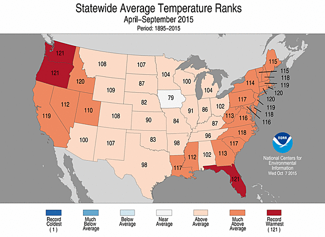
April-September 2015 Statewide Temperature and Precipitation ranks
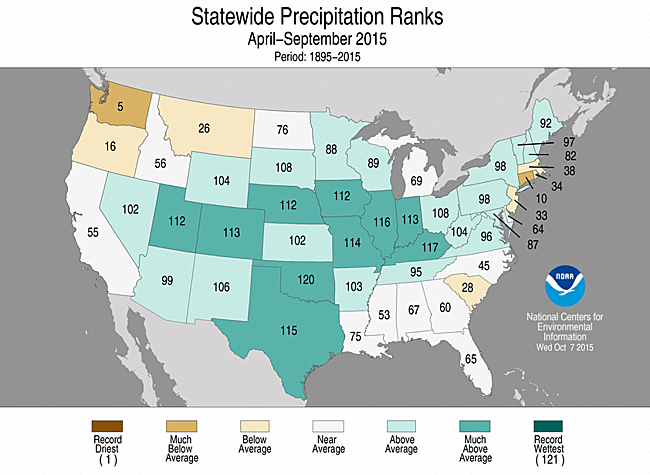
Precipitation
- The warm season contiguous U.S. precipitation total was 18.53 inches, 2.29 inches above average and the fourth wettest on record. This was the wettest warm season for the contiguous U.S. since 1957. A majority of the warm season precipitation fell from April-July, with August-September being relatively dry.
- Much-above-average precipitation was observed across the central U.S., from the Great Basin, through the Great Plains and Midwest, and into the Northeast. Ten states had six-month precipitation totals that were much above average. Parts of New England and the Northwest were drier than average, where Connecticut had its tenth driest warm season and Washington had its fifth driest.
Extremes
- The U.S. Climate Extremes Index (USCEI) for the warm season was 35 percent above average and the 18th highest value on record. On the national scale, extremes in warm maximum and minimum temperatures, days with precipitation, and the spatial extent of drought were much above average. The warm minimum temperature component of the USCEl was record high. The USCEI is an index that tracks extremes (falling in the upper or lower 10 percent of the record) in temperature, precipitation, land-falling tropical cyclones, and drought across the contiguous United States
- Regionally, the Northwest had its highest warm season CEI on record due to warm maximum and minimum temperatures and the spatial extent of drought. The West had its second highest warm season CEI due to warm maximum and minimum temperatures, the spatial extent of drought, and days with precipitation.
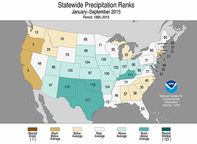
- Climate Highlights — year-to-date (January–September)
Temperature
- The year-to-date contiguous U.S average temperature was 56.9°F, 1.9°F above average, the eighth warmest on record. This was also the warmest year-to-date since 2012. Above-average temperatures were observed in the West and Southeast. Overall, 13 states, including Alaska, were much warmer than average. California, Nevada, Oregon, and Washington were each record warm with temperatures more than 4.0°F above the 20th century average. Below-average temperatures were observed in the Midwest and Northeast.
- The Alaska year-to-date temperature was 33.7°F, 3.6°F above average. This was the fourth warmest January-September on record and the warmest since 2005.
- The year-to-date contiguous U.S. maximum (daytime) temperature was 69.0°F, 1.7°F above average and the 10th warmest on record. Oregon and Washington had record-warm year-to-date maximum temperatures. Below-average maximum temperatures were observed in the Ohio Valley.
- The year-to-date contiguous U.S. minimum (nighttime) temperature was 44.9°F, 2.0°F above average and the fifth warmest on record. Nine states in the West had a record warm year-to-date minimum temperature. Below-average minimum temperatures were observed in the Northeast.
- Based on NOAA's Residential Energy Demand Temperature Index (REDTI), the contiguous U.S. temperature-related energy demand during January-September was 21.7 percent above average and the 35th highest in the 1895-2015 period of record.

January-September 2015 Statewide Temperature and Precipitation ranks
Precipitation
- The year-to-date precipitation total for the contiguous U.S. was 24.23 inches, 1.03 inches above average, and the 32nd wettest on record. Above-average precipitation was observed across the central U.S., where Kentucky, New Mexico, Oklahoma, and Texas were much wetter than average. No state was record wet for the year-to-date.
- Below-average precipitation was observed along both coasts. California, Connecticut, and Oregon each had precipitation totals that were much below average. California had its fourth driest year-to-date receiving about half its average precipitation.
Extremes
- The USCEI for the year-to-date was 25 percent above average and the 23rd highest value on record. On the national scale, extremes in warm maximum and minimum temperatures, one-day precipitation totals, and days with precipitation were much above average.
- Regionally, the Northwest had its highest year-to-date CEI on record due to warm maximum and minimum temperatures, the spatial extent of drought, and one-day precipitation totals. The CEI was near-record high in the West due to warm maximum and minimum temperatures and the spatial extent of drought, and in the Southwest due to warm maximum and minimum temperatures.
**A comparison of the national temperature departure from average as calculated by NCDC's operational dataset (nClimDiv), the U.S. Historical Climatology Network (USHCN), and the U.S. Climate Reference Network (USCRN) is available on our National Temperature Index page.**
Regional Highlights:
These regional summaries were provided by the six Regional Climate Centers and reflect conditions in their respective regions. These six regions differ spatially from the nine climatic regions of the National Climatic Data Center.
- Northeast Region: (Information provided by the Northeast Regional Climate Center)
- The Northeast had its second warmest September on record. The region's average temperature of 65.6 degrees F (18.7 degrees C) was 4.9 degrees F (2.7 degrees C) above normal. Maine, Connecticut, and Rhode Island had record-warm Septembers. Five states ranked this September as their second warmest: New York, Vermont, New Hampshire, New Jersey, and Massachusetts. Pennsylvania and Delaware had their third warmest Septembers, while Maryland had its ninth warmest. Departures for the Northeast states ranged from 3.0 degrees F (1.7 degrees C) above normal in West Virginia to 6.0 degrees F (3.3 degrees C) above normal in Maine. In Allentown, Pennsylvania, the temperature reached 90 degrees F (32 degrees C) or higher seven times in September, tying the site's record for greatest number of 90 degrees F (32 degrees C) days for the month.
- Two heavy rain events, one mid-month and one the last two days of the month, tipped September over to the wet side of normal. The Northeast received 4.42 inches (112.27 mm) of precipitation, which is 112 percent of normal. Seven of the twelve states saw above-normal precipitation, with departures ranging from 104 percent of normal in Massachusetts to 136 percent of normal in New Hampshire. Departures for the other five states ranged from 80 percent of normal in Delaware to 100 percent of normal in Rhode Island.
- At the beginning of September, 24 percent of the Northeast was abnormally dry, with 3 percent of the region experiencing moderate drought. Above-normal temperatures and below-normal precipitation during the month contributed to declining soil moisture and low streamflows. With that, abnormal dryness expanded to 53 percent of the region, while moderate drought expanded to 6 percent of the region, according to the U.S. Drought Monitor released on September 24.
- September's weather had numerous impacts. USDA reports indicated that some pastures were very dry and that various crops were smaller in size due to lack of water; however, pumpkins ripened earlier than usual due September's warmth and harvest was ahead of schedule in several areas. Falling water levels in reservoirs and wells led to voluntary and mandatory water restrictions in parts of New England, New York, and New Jersey. The prolonged warmth in September delayed the onset of the fall foliage season across much of the Northeast, with delays of up to two weeks in New England. Water temperatures were warm, as well. Lake Erie's water temperature at the Buffalo Water Treatment Plant was 75°F (24°C) on September 11, tying the record high for that date. In addition, Lake Champlain's water temperature at the King Street ferry dock in Burlington, Vermont on September 22 was 71°F (22°C), which is more typical of late July through mid-August. While most of the month was dry, two storms did bring heavy rain to the region. From September 10 to 11, a low pressure system moved through the Mid-Atlantic and up the East Coast, dropping up to 8 inches (203 mm) of rain along the way. Philadelphia International Airport's total of 4.76 inches (120.90 mm) was the site's second greatest 1-day September precipitation amount. From September 29 to 30, a slow-moving cold front interacted with tropical moisture to bring up to 8 inches (203 mm) of rain to the region. Two tornadoes were reported: an EF-0 in Prince Georges County, MD on September 29 and an EF-1 in Lancaster County, PA on September 30. The heavy rain during both storms triggered flash flooding, with cars stranded, roads closed, and basements flooded.
- For more information, please go to the Northeast Regional Climate Center Home Page.
- Midwest Region: (Information provided by the Midwest Regional Climate Center)
- Precipitation in September was below normal for the Midwest as a whole. Local precipitation totals varied widely however with totals ranging from about 25 percent of normal to twice normal. Statewide values averaged out to near normal for Iowa and Wisconsin, while Kentucky and Missouri were close to half of their normal values. Locations with heavy rainfall dotted the map with totals over 10 inches (254 mm) occurring in four states. Amery, Wisconsin had 12.19 inches (310 mm), Hoopeston, Illinois had 11.74 inches (298 mm), Glenwood, Iowa had 11.63 inches (295 mm), and Portage, Indiana had 10.64 inches (270 mm). On the other end of the spectrum, Columbia, Missouri experienced its driest August-September period since 1999.
- The average temperatures for September were well above normal in the upper Midwest and ranged to just above normal in the southeast portions of the region. This was the second warmest September on record (1895-2015) for the region falling below only September 1931. Minnesota, Wisconsin, and Michigan all set a new September record statewide while Iowa (3rd), Ohio (4th), and Illinois (7th) ranked among the ten warmest. Temperatures were very warm in the first week of the month with many locations setting or matching the warmest day of the year during the week. Cooler weather followed in the next week but warmer than normal temperatures returned for the latter half of the month.
- Drought was persistent in September for a few counties in the southwest corner of the state. New areas of drought emerged in Kentucky and southeast Indiana in the latter half of the month. The area affected by drought was only about 1 percent of the region while abnormally dry conditions were in place for roughly 20 percent of the Midwest.
- Severe weather was recording in the Midwest on half of the days in September. Reports were on the first 11 days, the 16th-18th, and on the 22nd with most occurring on just six days, the 3rd and 4th, the 8th, the 10th, and the 17th and 18th. Tornadoes touched down in Ogemaw County in Michigan on the 8th, Mason County in Illinois on the 10th, and both Will County in Illinois and Cass County in Missouri on the 18th. Hail size ranged up to 1.75 inches (44 mm) in diameter.
- Generally warm and dry conditions in many locations allowed for harvest to begin. Soybean harvest was ahead of the 5-year average pace in all but Iowa and Wisconsin where it was about 5 to 10 percent behind. Corn harvest trailed the 5-year average by 5 to 10 percent in all nine states. Crop conditions for both corn and soybeans remained steady during the month with no big departures, for the better or the worse, from August reports. Wheat planting was running close to average in the region.
- For details on the weather and climate events of the Midwest, see the weekly summaries in the Midwest Climate Watch page.
- Southeast Region: (Information provided by the Southeast Regional Climate Center)
- Temperatures were near average to above average across much of the Southeast region during September. The greatest departures were found across Virginia and eastern North Carolina, where monthly temperatures were 2 to 4 degrees F (1.1 to 2.2 degrees C) above average. Within this area, Bassett, VA (1953-2015) and Plymouth, NC (1945-2015) observed their second and fifth warmest mean temperatures for September on record, respectively. Portions of central and southern Florida were also unusually warm during the month. Vero Beach, FL (1943-2015) tied its second warmest September mean temperature on record, and Ft. Lauderdale, FL (1913-2015) observed its third warmest September mean temperature on record. Mean temperatures were above average in Puerto Rico and the U.S. Virgin Islands, as Juncos, PR (1931-2015) observed its warmest September mean temperature on record. The warmest weather of the month occurred from the 2nd through the 4th, as a high pressure system persisted over the region. During this three-day period, maximum temperatures exceeded 90 degrees F (32.2 degrees C) across all states within the region, with a few locations reaching the upper 90s F (36.1 to 37.2 degrees C). In contrast, the coolest weather of the month occurred from the 13th through the 15th, as a cold front ushered in cool Canadian air. Daily minimum temperatures were below 60 degrees F (15.6 degrees C) across much of the region north of Florida, with several locations approaching the lower 40s F (5.0 to 6.1 degrees C). On the 14th, the minimum temperature in Asheville, NC (1879-2015) was 40 degrees F (4.4 degrees C), which is tied for the third earliest observation of 40 degrees F or less at this location.
- Precipitation was highly variable across the Southeast region during September. The driest locations were found across central and northern Alabama as well as portions of east-central Georgia and southeastern North Carolina, where monthly precipitation totals were between 10 and 50 percent of normal. As one of the driest reporting stations in the Southeast for the month, Muscle Shoals, AL (1893-2015) tied its seventh driest September on record with only 0.55 inch (14 mm) of precipitation. Precipitation was also below normal across much of Puerto Rico and the U.S. Virgin Islands, where Coloso, PR (1905-2015) observed its fourth driest September on record with 4.02 inches (102 mm) of precipitation. In contrast, the wettest locations were found across western Virginia, northwestern and coastal North Carolina, central South Carolina, southeastern Alabama, and the western portion of the Florida Panhandle, where monthly precipitation totals were 3 to 8 inches (76 to 203 mm) above normal. Blacksburg, VA (1953-2015) observed its third wettest September on record with 8.61 inches (219 mm) of precipitation. Over half of this monthly total occurred in a single day, with 4.39 inches (112 mm) of precipitation observed on the 29th, making it the all-time wettest day on record for this location. On the 27th, Mobile, AL (1871-2015) recorded its fourth wettest September day and tenth wettest 1-day total with 7.50 inches (191 mm) of precipitation. The next day, an astounding 12.85 inches (326 mm) of precipitation was observed at Destin-Ft. Walton Beach Airport, FL. The greatest 6-hour precipitation total from this event was 10.10 inches (257 mm), which corresponds to an average recurrence interval of 100 years for this location.
- There were 157 severe weather reports across the Southeast during September, which is over 150 percent of the median monthly frequency of 97 reports during 2000-2014. Approximately 75 percent of these reports were for damaging thunderstorm winds, which is typical for early autumn. At least one severe weather report was recorded within the region on 16 days during the month, but one-third (52) of all reports occurred on the 4th, as widespread thunderstorms developed across the Carolinas and Virginia. Very few high wind gusts were observed during the month, with the exception of a 78 mph gust recorded by a 200-foot observation tower in Barnwell County, SC on the 10th. Only four tornadoes (3 EF-0s, 1 EF-2) were confirmed across the Southeast during the month, which is well below the short-term (2000-2014) median frequency of 14 tornadoes observed during September. On the 25th, an EF-2 tornado touched down just before 1 AM EDT in Johns Island, SC, located about 10 miles to the southwest of Charleston. Approximately 70-80 homes sustained minor damage, and two residences were almost completely destroyed. In addition, thousands of trees were uprooted or snapped off, with some falling onto adjacent structures and vehicles. No fatalities or injuries were reported with this nocturnal tornado. On the 8th, a woman working on the tarmac at Palm Beach International Airport was injured after being struck by lightning.
- Drought conditions improved substantially across much of the Southeast region during September. The percentage of the region under drought-free conditions (less than D1) increased significantly from 76 percent on the 1st to 88 percent on the 29th. Drought improvement was especially prevalent across the Carolinas during the final week of the month, where the coverage of moderate-to-severe (D1-D2) drought conditions decreased from 41 (66) to 18 (32) percent across North and South Carolina, respectively. The localized area of extreme (D3) drought in far southern Florida was completely eliminated by the end of the month, and moderate drought was partially ameliorated in portions of central Georgia, southern Alabama, and the Florida Panhandle. In addition, the coverage of extreme drought conditions across eastern Puerto Rico decreased from 25 to 15 percent by the end of September. Abundant rainfall during the latter half of the month increased soil moisture levels and aided in the planting of winter wheat and rye across portions of Florida and Georgia. However, the harvesting of several field crops, including cotton, peanuts, and soybeans, was delayed due to the persistent rainfall extending from northern Florida to Virginia.
- For more information, please go to the Southeast Regional Climate Center Home Page.
- High Plains Region: (Information provided by the High Plains Regional Climate Center )
- September was a record-setting month for much of the High Plains region and beyond. The jet stream stayed well to the north of the region in Canada, which allowed for unseasonably warm temperatures. The month started off extremely warm with temperatures soaring above 100 degrees F (37.8 degrees C) in central and western portions of Kansas, Nebraska, South Dakota, and North Dakota. Daily average temperature departures ranged from 10.0-20.0 degrees F (5.6-11.1 degrees C) above normal for several days. Although there was a dip in the middle of the month, temperatures rebounded and this resulted in an overall very warm month for the region. Across the U.S., temperature departures of 3.0-6.0 degrees F (1.7-3.3 degrees C) were common for parts of the Southwest, the Plains, the Midwest, and the Northeast. Embedded areas of the Plains, upper Midwest, and Northeast had average temperature departures in excess of 6.0 degrees F (3.3 degrees C) above normal. The only areas to have average temperatures which were below normal were the Pacific Northwest and portions of the southeastern U.S. Precipitation was variable across the country with much of the western and south-central U.S. receiving, at best, 25 percent of normal precipitation. This translated into deficits of at least 1.50 inches (38 mm) for a large area encompassing Texas through Alabama and portions of Oklahoma, Kansas, and Missouri. Meanwhile, precipitation totals of at least 150 percent of normal occurred for some areas of the East Coast, southern portions of California and Arizona, a few pockets of the central U.S., and an area stretching from northern Utah through Montana. Overall, the generally warm and dry conditions were good for producers as these helped progress the maturity of late planted crops, aided in the dry down process, and allowed for fall harvesting and/or planting activities to begin. According to the United States Department of Agriculture (USDA), record corn and soybean yields are expected in both Nebraska and South Dakota, while record hard spring wheat yields are forecast for North Dakota.
- It was an extremely warm month for the High Plains region with average temperatures generally in excess of 4.0 degrees F (2.2 degrees C) above normal. The largest departures occurred across eastern Colorado, much of western and central Kansas, southern and central Nebraska, eastern Wyoming, and pockets of the Dakotas where temperature departures were 6.0-8.0 degrees F (3.3-4.4 degrees C) above normal. These higher than normal temperatures caused numerous locations in every state of the region to be ranked in the top 10 warmest Septembers on record and some new records were also set. For instance, Denver, CO, Fargo, ND, Lead, SD, and Cheyenne, WY all had their warmest September on record. Meanwhile, a sampling of locations ranking in the top 10 warmest included Casper, WY (2nd), Goodland, KS (3rd), Omaha, NE (4th), Bismarck, ND (5th), Boulder, CO (6th), and Sioux Falls, SD (7th). For western areas of the region, this warmth was not isolated to September as above normal temperatures have been experienced much of the year in places like Pueblo, Colorado and Cheyenne, Wyoming. For instance, at the end of the month, Cheyenne's year-to-date average temperature was 51.8 degrees F (11.0 degrees C). This was 2.2 degrees F (1.2 degrees C) above normal and ranked as the 2nd warmest January 1-September 30 on record (period of record 1872-2015). Similarly, Pueblo had its 7th warmest January 1-September 30 with an average temperature of 58.3 degrees F (14.6 degrees C), which was 2.6 degrees F (1.4 degrees C) above normal (period of record 1888-2015).
- It was a fairly dry month across the High Plains region, with large areas receiving little to no precipitation. Large portions of Wyoming, eastern Colorado, western and northern South Dakota, and southern and eastern North Dakota all received less than 50 percent of normal precipitation. For the majority of the dry areas, this translated into a deficit of less than an inch (25 mm); however, in areas of northeastern South Dakota and southwestern Kansas, deficits were in excess of 2.00 inches (51 mm). The exceptions to the dryness included western Wyoming, western and northern North Dakota, and an area stretching from north-central Nebraska/south-central South Dakota to the east into eastern Nebraska and western Iowa. These areas received at least 150 percent of normal precipitation. The wide range in precipitation totals led to extremes on both ends of the spectrum and many locations ranked in either the top 10 driest or the top 10 wettest Septembers on record. Some dry examples included Casper, WY (7th driest), Boulder, CO (9th driest), and Rapid City, SD (10th driest). Meanwhile, wet locations included Omaha, NE (3rd wettest) and Topeka, KS (10th wettest). Pueblo, Colorado was one of the drier locations this month and only received 0.03 inches (1 mm) of precipitation. This amount ranked as the 6th driest September on record and was a mere 4 percent of normal. Although a paltry amount, this could not beat the record of a Trace that is shared with the Septembers of 1892, 1916, and 1956 (period of record 1888-2015). Interestingly, Pueblo went from one extreme to the other as it just had its 6th wettest August last month. On the wet side, Omaha, Nebraska had an impressive month with 9.31 inches (236 mm) of precipitation, which was 6.63 inches (168 mm) above normal, or 347 percent of normal. Much of the precipitation fell in a two day period, the 23rd and 24th, when storms brought heavy rain that caused street flooding, power outages, and even some school closings. On the 23rd, 5.74 inches (146 mm) fell, setting a new daily record, and on the 24th, 1.48 inches (38 mm) fell. The 2-day total came to 7.22 inches (183 mm), which set a new 2-day rainfall record for September in Omaha. The old record of 7.20 inches (183 mm) set on September 7-8, 1965 was narrowly beat (period of record 1871-2015). This was the second wet month in a row for Omaha, which, like Pueblo, also had its 6th wettest August last month.
- The drier conditions across the High Plains region this month led to some changes in the U.S. Drought Monitor. While not a major change, the total area in drought (D1-D4) in the region did increase to just under one percent. At the end of the month, two areas of moderate drought conditions (D1) were present - one in the far southwest corner of Wyoming and the other in northwestern Kansas. The small area of drought in Wyoming has persisted for several months; however, the drought area in Kansas developed over the past month due to warm and dry conditions. At the end of last month, Kansas was drought free for the first time since 2010. Unfortunately, this drought free period did not last long. Elsewhere, abnormally dry conditions (D0) developed or expanded in portions of all the states in the High Plains region. This included central and eastern Colorado, eastern Wyoming, western and southern Nebraska, southwestern South Dakota, and eastern North Dakota. While D0 does not indicate drought, it does show areas that should be monitored for possible development. D0 now encompasses almost 25 percent of the region. Taking a look to the west shows that extreme drought conditions (D3) improved slightly in northwestern Montana, while moderate (D1) and severe (D2) drought conditions expanded slightly. Outlooks still indicate increased chances for a warmer and drier winter, so conditions should continue to be monitored in the coming months.
- For more information, please go to the High Plains Regional Climate Center Home Page.
- Southern Region: (Information provided by the Southern Regional Climate Center)
- September temperatures in the Southern Region were much warmer than normal, particularly in western Texas and western Oklahoma, where anomalies ranged from 4 - 8 degrees F (2.22 - 4.44 degrees C) above normal. Along the Gulf Coast and in the eastern portions of the region, temperatures were above normal, but much closer to normal, with stations ranging between 0-2 degrees F (0 - 1.11 degrees C) above expected values. The state-wide average temperatures for the month are as follows: Arkansas averaged 74.70 degrees F (23.72 degrees C), Louisiana averaged 78.40 degrees F (25.78 degrees C), Mississippi averaged 76.26 degrees F (24.56 degrees C), Oklahoma averaged 76.60 degrees F (24.78 degrees C), Tennessee averaged 71.00 degrees F (21.67 degrees C), and Texas averaged 79.30 degrees F (26.28 degrees C). Texas experienced its eighth warmest September on record, while for Oklahoma it was the twelfth warmest September. Arkansas and Louisiana recorded their thirty-third and thirty-fifth warmest September on record, respectively. All other state rankings fell within the two middle quartiles. All records are based on the period spanning 1895-2015.
- September was a drier than normal month for all states in the Southern Region, and an extremely drier than normal month for the majority of counties in central Texas, northern Louisiana, northern Mississippi, southern Arkansas and southern Oklahoma. Precipitation totals in the central portions of the region ranged from zero to twenty-five percent of normal. The state-wide average precipitation totals for the month are as follows with: Arkansas reporting 1.44 inches (36.58 mm), Louisiana reporting 2.65 inches (67.31 mm), Mississippi reporting 1.72 inches (43.69 mm), Oklahoma reporting 1.78 inches (45.21 mm), Tennessee reporting 2.57 inches (65.28 mm), and Texas reporting 1.41 inches (35.81 mm). Arkansas experienced their eleventh driest September on record, while Texas and Mississippi reported their fifteenth and eighteenth driest, respectively. The state of Oklahoma experienced their twenty-second driest September, while for Louisiana, it was the twenty-sixth driest on record. Though it was drier than normal in much of Tennessee, their monthly state-wide temperature ranks out at thirty-fifth driest. All records are based on the period spanning 1895-2015.
- Drier than normal conditions, combined with above average temperatures spelled a recipe for drought expansion across the central portions of the Southern Region. Over the month of September, the areal coverage of drought in the region increased by approximately thirteen percent. More dramatically, the amount of extreme drought increased by over five percent. As of September 29, 2015, extreme drought is located in the Arkansas-Louisiana-Texas border region, where conditions have been unusually dry. Similar drought patterns can be observed in east central Texas and in central Mississippi.
- Because September was an extremely dry month for most of the Southern Region, there was little to no severe weather reports. On September 8, 2015, a cluster of wind reports were made in central Oklahoma. Reports generally noted downed tree limbs, but wind velocities were cited.
- For more information, please go to the Southern Regional Climate Center Home Page.
- Western Region: (Information provided by the Western Region Climate Center)
- Well-above normal temperatures were present across southern California, the southern Great Basin, and the central and southern Rocky Mountain states. Temperatures were slightly cooler than normal in the Pacific Northwest. Remnants of tropical storms interacting with upper level low-pressure systems produced above normal precipitation in scattered areas of the West.
- In the beginning of the month, a low-pressure system moved across the Northwest, bringing below normal temperatures and welcome precipitation for areas that saw onset of drought this past summer. Mid-month, the remnants of Hurricane Linda interacting with an upper level low brought precipitation to several areas. Near record precipitation was observed in Southern California, where Los Angeles had its 3rd wettest September at 2.39 in (61 mm); normal September precipitation at this location is 0.24 in (6 mm). All rain fell on the 15th, which became the second wettest September day since records began in 1877. Moisture was dragged northeastward, bringing precipitation to areas of Utah, Idaho, and western Montana in association with this moisture plume. Butte, Montana observed 2.36 in (60 mm) for the month, 236% of normal. Further west, Stanley, Idaho recorded 2.09 in (53 mm) for September, 227% of normal and the 4th wettest September since records began in 1916. Towards the end of the month, remnants of Tropical Depression 16E moved across the southwest boosting monthly precipitation totals across southeastern Arizona and New Mexico. Nogales, along the southern Arizona border, recorded 5.47 in (139 mm) this month, 360% of normal. This precipitation helped to erase drought conditions along the southern Arizona and New Mexico borders.
- Some areas of the West received little precipitation, which is not unusual for September. Sacramento, California received no precipitation this month (normal is 0.35 in /9 mm), though this has occurred in 38 other years in Sacramento's 139-year record. Several areas east of the Rockies saw a drier than normal September as well. Buffalo, in north-central Wyoming recorded 0.11 in (3 mm) for the month, 8% of normal. Areas of eastern Colorado and Wyoming moved into the US Drought Monitor's 'abnormally dry' category. No other areas of drought degradation were observed in the West this month.
- After a three-month streak of above normal temperatures, a few low-pressure systems brought cooler air to the Pacific Northwest this month. Temperatures averaged to slightly cooler than normal for this region, with departures of 0-3 F (0-2 C) below normal. Elsewhere in the West, warmer temperatures dominated. In coastal southern California, temperatures at Santa Maria averaged to 71.2 F (21.8 C), 8 F (4.4 C) above normal and the second warmest month of all months in a 68-year record. The Great Basin also saw above normal temperatures. In eastern Nevada, Ely observed its warmest September on record at an average 62.3 F (16.8 C), 5.5 F (3 C) above normal. Temperatures were above normal in the central and southern Rocky Mountain states as well, especially east of the Rockies. Temperatures at Pueblo, Colorado averaged to 72.0 F (22.2 C), 7.3 F (4 C) above normal and the warmest September in a 62-year record. Every day this September had above normal average temperatures in Pueblo.
- An active hurricane season in the central and eastern Pacific supported a wetter than normal September for much of the Hawaiian Islands. Record or near record September precipitation was observed at several locations. Honolulu had its wettest September on record at 4.48 in (114 mm), 2.08 in (53 mm) greater than the previous record set in 1947. Records for Honolulu began in 1940. Further north, temperatures across Alaska were slightly cooler than normal this month with the greatest departures in the Interior of 2-4 F (1-2 C) below normal.. Fairbanks reported an average 42.4 F (5.7 C), 2.5 F (1.4 C) below normal. Much of South Central and Interior Alaska were wetter than normal. Fairbanks and Anchorage both recorded their wettest Septembers on record at 3.74 in (95 mm), 340% of normal and 7.71 in (196 mm), 258% of normal, respectively. Records for Fairbanks began in 1929 and for Anchorage in 1952.
- September 14: Flooding in Southern Utah: Flash flooding associated with remnants of Hurricane Linda killed 13 in Hildale Utah when their cars were washed away by fast moving water. In nearby Zion National Park, 7 hikers trapped during flash flooding died in a narrow canyon resulting in a total 20 deaths from this event.
- September (all month): Early snow for parts of Alaska: Unusually early snow fell in Fairbanks on the 13th and in Anchorage on the 18th, blanketing elevated terrain in these areas with several inches of snow. The last early occurrence of snow was 1992 in Fairbanks and 1993 in Anchorage.
- September 30: End of Southwest Monsoon Season: The monsoon season, which began on June 15, was average this year with most of Arizona and New Mexico receiving 75-125% of normal precipitation. Much of the precipitation did not result from a traditional Southwest Monsoon pattern setting up in the atmosphere and bringing moisture from the Gulf of Mexico, but from the availability of moisture from the remnants of tropical storms.
- For more information, please go to the Western Regional Climate Center Home Page.