September
Temperatures

larger
image
|
The graph to the left
shows monthly mean temperature averaged across the contiguous
United States based on long-term data from the U.S. Historical
Climatology Network (USHCN). The value for
2002 is estimated from preliminary Climate Division data using the
first difference approach. September 2002 ranked as the 7th warmest September in
the 1895 to present record. The preliminary nationally averaged
temperature was 67.7° F (19.8° C) which was 2.2° F
(1.2° C) above the long-term mean. The September temperature values
from 1895 through 2002 are available. |
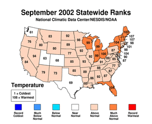
Much above average
warmth occurred in 11 contiguous states in September. No statewide
mean temperature records were set for the month, though New
Hampshire and Vermont
had their second warmest September since 1895 and their warmest
September in over 40 years. No state averaged temperature was
significantly cooler than the mean for the month with only 4 (WA,
UT, CO, TX) out of the lower 48 states having near average
temperatures.
Significantly cooler than average temperatures were evident only in
southeastern Texas as can be seen in the map of divisional
temperature (below right). The pattern of warmth and cold in the
contiguous U.S. in September broadly corresponds with the mean
500mb height and anomalies chart. This shows that well above
normal 500mb heights existed across the northeastern quadrant of
the country, which is associated with the much higher than average
temperatures in September. Temperatures in Alaska
were above normal relative to the period 1971-2000 for the second
consecutive September. |
larger
image
 Click
here for animated image
Click
here for animated image
|
Temperature
Departures
| The map to the right,
based on over 500 airport stations, shows departures from the
1971-2000 normal temperatures for September 2002. Warmer than
average temperatures extended across the entire eastern half of the
contiguous U.S., with some of the largest departures (greater than
6°F [3.3°C]) occurring in the Northeast and central and
eastern Great Lakes region. Negative temperature anomalies were
limited to coastal southern California and scattered stations from
southeastern Texas to Seattle, Washington. An animated map of daily temperature anomalies
shows temperature variability throughout the month of
September. |

larger
image
|
July-September 2002

larger
image
|
The graph to the left
shows mean temperature averaged across the contiguous United States
based on long-term data from the U.S. Historical Climatology
Network (USHCN). The value for
July-September 2002 is estimated from preliminary Climate Division
data using the first difference approach. July-September 2002 ranked as the
4th warmest such period in the 1895 to present
record. The last 6 July-Septembers have been above average. The
year 1998 was the warmest July-September on record followed by 1936
and 1931. The preliminary nationally averaged temperature for
July-September 2002 was 72.6° F (22.6° C) which was
1.7° F (0.9° C) above the long-term mean. |
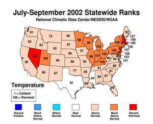
Statewide
mean temperatures for the July-September period were warmest on
record for five states (New
Hampshire, Rhode
Island, New
Jersey, Massachusetts,
and Nevada)
and much above average for a further 14 states, with Connecticut
and Vermont
having their second warmest July-September on record.
Significantly above average statewide
mean temperatures also occurred in all but 2 (TX and MS) of the
remaining contiguous states with no state during July-September
period, averaging temperatures significantly cooler than the
long-term mean. Even when broken down by climate division (see
graph below right), there are only 4 divisions which were
significantly cooler than average during this period and these
occurred in central Texas. Record warm temperatures averaged over
the July-September period were recorded in several eastern
divisions (Ohio, New York, Vermont, New Hampshire, Massachusetts,
Rhode Island and New Jersey) and two western divisions (Nevada and
California).
Temperatures in Alaska
were above average for the three months. In the last 10 years,
there have only been 3 July-Septembers in Alaska with below average
temperatures.
|
larger
image
 larger
image
larger
image
|
January-September 2002
(year-to-date)
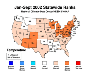
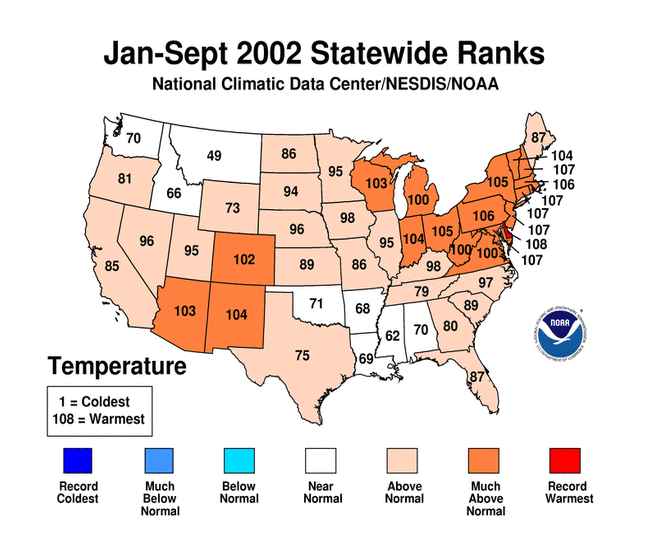
Statewide
mean temperature for the January-September period was much
above average for 19 states, with Delaware
having its record warmest January-September in 108 years. New
Hampshire, Rhode
Island, Connecticut,
New
Jersey and Maryland
all had their second warmest January-Septembers on record.
Significantly above average statewide
mean temperatures also occurred in 39 out of the 48 contiguous
states with the remainder showing near average temperatures for the
year-to-date. Over the January-September period, no state-averaged
temperature was significantly cooler than the long-term mean. Even
when broken down by climate division, there are only 4 divisions
which were significantly cooler than average during this period and
these occurred in Montana, Idaho and Arkansas, as can be seen in
the map below right. Record warm temperatures averaged over the
January-September period occurred in several east coast divisions
(in Virginia, Maryland, Delaware, New York, Connecticut and
Massachusetts).
The pattern of January-September temperature for the contiguous
U.S. corresponds quite well with height
anomalies in the 500mb level of the atmosphere. Though the
positive height anomalies were not large for the January-September
period, they were associated with warmer than average temperatures
across the East and mid-section of the contiguous U.S., as well as
the Southwest. Averaged over the last 9 months, there were no
significant negative height anomalies and where the height
anomalies were near average (the Northwest Central region), so were
the Statewide
temperature averages. |
larger
image
 larger
image
larger
image
|
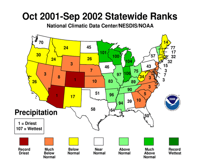
National Temperatures -
October 2001-September 2002

larger
image
|
The graph to the left
shows monthly mean temperature averaged across the contiguous
United States based on long-term data from the U.S. Historical
Climatology Network (USHCN). October
2001-September 2002 ranked as the 3rd warmest such
period in the 1895 to present record. The preliminary nationally
averaged temperature was 54.6°F (12.6°C) which was
1.8°F (1.0°C) above the long-term mean. |
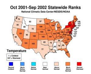
| Record warmth occurred
in eight states (NY, NH, MA, RI, CT, NJ, DE and MD) averaged over
the last twelve months. The pattern of state-averaged monthly
temperature can be seen in the map to the right. Twenty-four other
states ranked in the top ten warmest such periods. Only three
states had near-average temperatures for October-September (MS, MT
and ID). |
larger
image
|
September
Precipitation

larger
image
|
The graph to the left
is a time series depicting precipitation averaged across the
contiguous U.S. Based upon preliminary precipitation data,
September 2002 was slightly wetter than average, ranking 74th
driest (35th wettest). There has been no significant trend in mean
national September precipitation over the last century, though
September is one of
only 3 months in 2002 which has averaged slightly more
precipitation than the mean. |
| There was considerable
regional variability in precipitation across the country. Four
states in the South (Mississippi,
Alabama,
Tennessee
and Kentucky)
and one in the Southwest (New
Mexico) received much above average rainfall in September,
while one state (California)
received much below average rainfall this month. Mississippi
and Tennessee
were second wettest on record for the month of September.
November 2001 was the last month that
Colorado received above average precipitation before this
month. However, despite the wetter than average September, it will
still take many months of above average or near average rainfall to
alleviate the long-term
drought in that state and others in the Southwest
and West.
Much of the above-average rainfall in the eastern half of the
country was a result of Tropical Storm
Isidore as it moved inland off the Gulf of Mexico on the 26th.
More details on September hurricanes and tropical storms can be
found here. |
 larger
image
larger
image
|

larger
image
|
In Indiana on September 20th, storms occurred
ahead of a strong cold front leading to numerous
reports of tornadoes and significant rainfall. At least two F2
tornadoes and one F3 tornado caused significant damage in Indiana.
The path of the F3 tornado was 112 miles in length, though the
tornado was not at that intensity for most of the distance.
Twenty-seven
separate reports of tornadoes were submitted to the Storm
Prediction Center - 24 in Indiana and 3 in Ohio. Although it is not
unusual for tornadoes to occur in the Midwest at this time of year,
the intensity of this outbreak was fairly unusual. Where
the F3 tornado passed through Marion County, damage estimates have
reached $36M for that county alone. (Information courtesy of the
Midwest Regional
Climate Center's Climate Watch). |
Earlier in the month, on Monday September 2nd, a tornado ripped
through the town of Ladysmith, in northwestern Wisconsin. A few
dozen injuries were reported and significant structural damage
occurred in the town of 4,000 residents.
Further details on flooding and rainfall in the Southeast and parts
of the Gulf Coast are given on the Atlantic hurricane
page, as they relate to landfalling tropical storms in
September.
Precipitation
Departures
| The map to the right,
based on more than 500 airport stations, shows September 2002 total
precipitation as a percent of the 1971-2000 station normals. Above
normal precipitation generally occurred in the South through the
Mississippi Valley and Tennessee/Ohio Valley regions, with more
than 190% of normal precipitation falling in some areas. Parts of
the Southwest also received more rainfall that normal, however,
dryness extended across most of the West and Northwest where as
little as 25% of normal rainfall was recorded. The Central Plains
were also dry this month, with less rainfall than normal also
extending into Michigan. |

larger
image
|
Last 3 months
(July-September)

larger
image
|
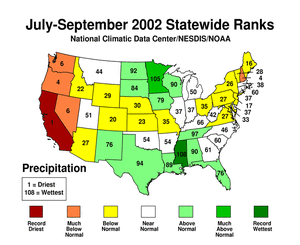
The graph to the left
is a time series depicting precipitation averaged across the
contiguous U.S. Based upon preliminary precipitation data,
July-September 2002 was wetter than average, ranking 73rd driest
(36th wettest) in the last 108 years. This belies considerable
regional variability as can be seen from the maps below. |
| Record dryness averaged over July-September
occurred in California
in 2002. Three other states in the West (OR, NV, and WA) and one in
the East (NH) also received much below average precipitation while
fifteen other contiguous states received significantly below
average precipitation. All Gulf Coast states as well as New Mexico,
Tennessee and part of the Upper Midwest and Northern Plains
received above average rainfall for the July-September period, with
Minnesota
at a rank of 4th wettest for the 3 months, and record wetness for
Mississippi.
Though July was quite wet for Mississippi, much of the 3-month
average rainfall came in September from Tropical Storm Isidore and
is discussed below and on the Atlantic hurricane
season web-page.
Minnesota has received much above average rainfall in three of
the last four months. |
National Precipitation -
October 2001-September 2002

larger
image
|
The graph to the left
is a time series depicting precipitation averaged across the
contiguous U.S. Based upon preliminary precipitation data, October
2001-September 2002 was drier than average, ranking 29th driest in
the last 107 such periods. The last 3 October-September periods
have averaged below the long term mean precipitation. |
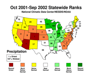
| Record dryness
occurred in 2 states (CO and AZ) averaged over the last 12 months.
The pattern of state-averaged October-September precipitation can
be seen in the map to the right. Twelve other states ranked in the
top ten driest such periods. More information on drought analysis
for these states and others can be found on NCDC's
Drought Pages. Four states (MN, WI, IN and MI) received much
above average rainfall for the 12-month period, with a second
wettest October-September occurring in Indiana. |
larger
image
|


