

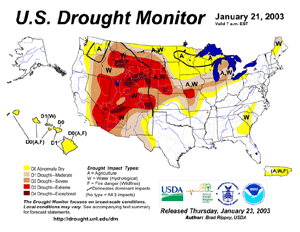
| Severe to exceptional
drought
continued throughout much of the western United States,
especially the Intermountain West. A series of storm systems
eradicated most of the persistent drought in the eastern U.S., as a
turn to wetter weather continued during September-December
2002. |
larger
image
|
Drought conditions expanded into the plains and lower Great
Lakes region, as dry weather continued. In Iowa, Des Moines
experienced a record 53-day long dry spell that ended on the 4th,
along with the warmest temperature ever recorded in January on the
8th (67°F or 19.4°C).

larger
image
|
Drought continued
throughout much of Australia during early January 2003. Drought
lowered milk production, the amount of cheese manufactured and the
value of dairy exports (Sydney Morning Herald). Wool yields were
down between 40-60 percent (ABC News) and the state of Victoria
cancelled its 2003 duck-hunting season due to the severity of the
nine-month long drought (Reuters). Dry conditions promoted
wildfires across areas of Queensland and Victoria in southeast
Australia in January. |
Hot temperatures exacerbated drought and wildfire conditions in
southeast Australia, as Melbourne recorded the 4th warmest day on
record on the 25th, with a maximum temperature of 44.1°C
(111°F)(Australian Bureau of Meteorology).
In Africa, severe drought affected 900,000 people in Zimbabwe's
southwestern province of Matabeleland. In one of Zimbabwe's worst
droughts in the last 50 years, up to 20,000 head of cattle were in
danger of dying (World Vision). Across the country, aid agencies
estimated that almost 7 million people in the country would require
food aid until the next harvest around March 2003. Across Ethiopia,
drought was expected to cause up to a 30 percent reduction in
coffee production, undermining the country's main cash crop (BBC
News). In Mauritania,
420,000 people were in need of food aid due to one of the worst
droughts in the last 20 years (CIP report, WFP).

 larger
image
larger
image
|
Heavy rainfall which
began over the weekend of December 28-29th across Belgium and the
Netherlands brought significant flooding to parts of the region. In
Belgium, flooding occurred along the Dender and Meuse rivers, and
in the southern Netherlands, the Maas river was above the flood
stage on the 2nd (Associated Press). Flooding affected areas of
Germany and the Czech Republic, with numerous rivers above flood
stage during the 2nd-3rd. |
A series of storm systems brought flooding to areas of the
United Kingdom, where numerous flood warnings had been issued
across southern England during the latter days of December into
early January 2003 (UK Met Office).
 larger
image
larger
image
|
In north Africa,
unseasonably heavy rain fell across northern Algeria and Tunisia
during the 22nd-28th. Flooding closed roads and caused 10
fatalities in Tunisia. |
| The nearly stationary
remnants of Tropical Cyclone Delfina
brought flooding to Malawi during January 1-7 and displaced more
than 30,000 people, washed away crops and roads, and was blamed for
7 deaths (Associated Press). The President of Malawi declared a
state of disaster on the 11th, describing the flooding as "a
disaster of the highest proportion." In neighboring Mozambique,
floods washed away an estimated 400 homes and disrupted power
supplies in one northern province (Reuters). |

larger
image
|
 larger
image
larger
image
|
Heavy rainfall in
early January caused flooding and landslides on the Indonesian
islands of Java and Sulawesi. Three people were killed and 2,000
homes destroyed in West Java (CIP report). |
In Bolivia, heavy rains brought the San Julian and Chutacagua
Rivers above flood stage, affecting several towns in the
departments of Cochabamba and Santa Cruz. Around 6,500 people were
affected and up to 80 percent of the crops were damaged in the
region affected by the flood (OCHA). Flash flooding affected the
Bolivian capital of La Paz on the 21st, causing two deaths
(Associated Press). In neighboring Peru, flooding displaced 5,000
families and caused 6 deaths (Reuters). Around 74,000 hectares
(30,000 acres) of agricultural land were affected and nearly 7,000
head of cattle were lost due to the flooding in Peru.
| Flooding rains brought
mudslides to the mountainous Brazilian city of Petropolis, outside
of Rio de Janeiro, on the 11th. Eleven people were killed as
mudslides buried three houses and flooded the nearby Piabanaha
River (Associated Press). Up to 180 mm (7 inches) of rain fell in
only an hour, which produced flash flooding in the city. Additional
mudslides produced 5 deaths in the greater Rio de Janeiro area on
the 29th while 8 people died outside of Sao Paulo on the 28th. |

larger
image
|
 larger
image
larger
image
|
A low pressure system
brought torrential rains to northern
Australia during January 10-13, 2003. Along the border of
Queensland and the Northern Territory, adjacent to the Gulf of
Carpentaria, up to 800 mm (31.5 inches) of rain fell. |
For an archive of flood events worldwide, see the
Dartmouth Flood Observatory.

A tornado struck the port area of Limassol in Cyprus on the
27th, injuring 28 people and producing damage to shops and
property. Another tornado affected the coastal area of Larnaca
where damage was reported to homes and property. (Associated
Press)

 larger
image
larger
image
|
Tropical Cyclone
Fari moved
across Madagascar during the 28th-29th before emerging over the
Mozambique Channel on the 30th. The storm produced heavy rains and
localized flooding, along with maximum sustained winds near 100
km/hr (~55 knots or 60 mph) at the time of landfall. |
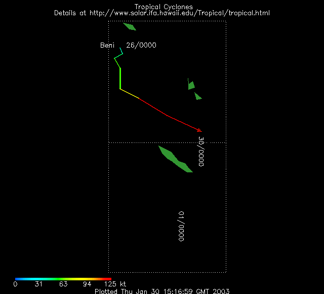
| Tropical Cyclone
Beni
developed in the south Pacific Ocean on the 26th and passed within
90 km (56 miles) of the eastern tip of Rennell in the Solomon
islands on the 26th. Winds gusted to between 90-110 km/hr (50-60
knots or 55-70 mph) at the town of Bellona as the cyclone passed
by, along with a 48-hour period of heavy rains. Property and
agricultural damage was reported on the island, with tree crops
such as coconuts, papaya and banana affected (OCHA). |

larger
image
|
 larger
image
larger
image
|
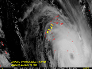
Tropical Cyclone
Ami developed
in the South Pacific Ocean on the 11th, and crossed Fiji and
surrounding islands during the 13th-14th with maximum sustained
winds near 185 km/hr (100 knots or 115 mph). The storm produced
wind damage and flooding to Fiji's Vanua Levu and surrounding
islands, where a state of emergency was declared by government
officials. The cyclone was blamed for 15 deaths on Fiji, and caused
millions of dollars in damage (USD) (Reuters). |
| Tropical Cyclone
Delfina developed in the Mozambique Channel on December 30, 2002
and made landfall in northern Mozambique late on the 31st with
maximum sustained winds near 100 km/hr (~55 knots or 65 mph). The
storm weakened as it moved slowly westward across Mozambique and
southern Malawi during January 1-2, 2003, bringing very heavy
rainfall. |

larger
image
|
Strong Santa Ana
winds resulted in scattered power outages throughout southern
California, with 30,000-40,000 customers losing power late on the
6th. Very warm temperatures accompanied the strong winds, with some
daily maximum temperatures reaching between 26-30°C
(80-85°F).

Across Bangladesh, unseasonably cold weather during the last
week of December 2002 into late-January 2003 was responsible for
the deaths of 530 people (Reuters). Most fatalities were reported
from the country's northern regions where temperatures fell to
between 2-4°C (36-39°F). Average minimum temperatures in
this region are generally between 12-14°C (54-57°F) in
early January.
| Unseasonably cold
temperatures also affected areas of Pakistan, northern India and
Nepal. In northern India, a total of 670 deaths were reported in
the northern state of Uttar Pradesh, with at least a dozen deaths
in Nepal blamed on the cold outbreak. (Deutsche Presse Agentur,
Bangkok Post, Reuters). |

larger
image
|
| Much of Asia
experienced colder than average temperatures during early to mid
January. In northwestern Russia, temperatures in early January
dropped as low as -45°C (-49°F), and parts of the Baltic
Sea had begun to freeze over (BBC News). |

larger
image
|
In Mongolia, the State Emergency Commission reported that
24,000 animals were reported dead during the first two weeks of
January 2003, due to extreme winter conditions.
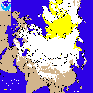 Europe/Asia Snow Cover
|
Heavy snow affected
parts of Europe during the first week of January. In the United
Kingdom, London reported its largest snowfall since February 1991
with up to 12 cm (5 inches) of accumulation (The Sentinel/UK Met
Office). Farther south, a rare significant snowfall fell in parts
of southern France, resulting in the temporary closure of two
airports in the region. To the east, heavy snow in Hungary and
Croatia halted most transportation and prompted the closing of the
border crossing between the two countries (ABC News). |
In China, a rare
snowfall in southwest China's Yunnan province early in January
caused traffic delays and flight cancellations out of the Kunming
city airport.
 Subfreezing Temperatures Across Florida
|
Cold temperatures
throughout much of the eastern United States penetrated into
Florida, with record temperatures observed in many areas on the
24th. Despite the subfreezing temperatures, significant damage to
citrus crops was avoided (Reuters). |
References:
Basist, A., N.C. Grody, T.C. Peterson and C.N. Williams, 1998:
Using the Special Sensor Microwave/Imager to Monitor Land Surface
Temperatures, Wetness, and Snow Cover. Journal of Applied
Meteorology, 37, 888-911.
Peterson, Thomas C. and Russell S. Vose, 1997: An overview of
the Global Historical Climatology Network temperature data base.
Bulletin of the American Meteorological Society,
78, 2837-2849.


