December Temperatures
larger imageThe graph to the left shows monthly mean temperature averaged across the contiguous United States based on long-term data from the U.S. Historical Climatology Network (USHCN). The value for 2002 is estimated from preliminary Climate Division data using the first difference approach. December 2002 ranked as the 21st warmest December in the 1895 to present record. The preliminary nationally averaged temperature was 35.8° F (2.1° C) which was 2.4° F (1.3° C) above the long-term mean.
Much above average warmth occurred in 4 northern U.S. states in December with a ranking of 8th warmest December on record for Idaho, Montana and Minnesota, while Nebraska ranked 10th. Much of the remainder of the western half of the continental U.S. (15 states) was also warmer than average for the month. Only 4 southeastern states had significantly below average temperatures for December (FL, AL, GA and SC), with the rest of the lower 48 states averaging temperatures close to the long-term mean. As can be seen in a map of divisional temperature (below right), significantly cooler than average temperatures also extended northward through the mid-Atlantic states. The pattern of warmth and cold in the contiguous U.S. in December broadly corresponded with the mean 500mb height and anomalies chart. This shows that well above normal 500mb heights extended from Canada into the northern Great Plains, which were associated with the much above average temperatures in December.
It was the 5th warmest December since reliable statewide records began in 1918 for Alaska , with anomalies of 4.9°F (2.7°C) above normal relative to the period 1971-2000.
larger imageClick here for animated image
Regional Temperature Ranks for the
Contiguous U.S., December 2002Region Rank Northeast 50th coldest / 59th warmest East North Central 93rd coldest / 16th warmest Central 65th coldest / 44th warmest Southeast 34th coldest / 75th warmest West North Central 102nd coldest / 7th warmest South 64th coldest / 45th warmest Southwest 74th coldest / 35th warmest Northwest 99th coldest / 10th warmest West 88th coldest / 21st warmest


Temperature Departures
The map below, based on over 500 airport stations, shows departures from the 1971-2000 normal temperatures for December 2002. In the lower 48 states, some of the largest widespread positive departures (greater than 7.5°F [4.2°C]) occurred in the Upper Mississippi Valley and Northern Great Plains. Most of the warmth in this region occurred around the middle of the month, and then again during the last few days of December (as can be seen in an animation of daily temperature anomalies).
A new maximum daily temperature record was set in Wichita Falls, KS on December 17th when the high reached 79°F (26.1°C) breaking the old December 17th maximum temperature of 77°F (25°C) set in 1980. Numerous other daily maximum temperature records were broken in the middle of the month over the central and north central areas of the country. However, Alaska had the largest monthly positive departures (greater than 9°F [5°C]) at many of its stations and additionally, many daily records were also being broken. McGrath, AK had its maximum daily temperature record shattered on December 3rd when the high reached 40 degrees (4.4°C). The previous high temperature for that date in McGrath was 30°F (-1.1°C) set in 1979.
larger image
The East coast had generally lower than average temperatures for December 2002. Much of the coolness for the east coast was during the first 10 days of the month and many locations had record low temperatures during that time. For example, Jackson, KY reached a low of 20°F (-6.7°C) on December 1st, breaking the old December 1st minimum temperature record by 2 degrees Fahrenheit (1.1°C).
See NCDC's Monthly Extremes web-page for more records.

October-December 2002
larger imageThe graph to the left shows mean temperature averaged across the contiguous United States based on long-term data from the U.S. Historical Climatology Network (USHCN). The value for October-December 2002 is estimated from preliminary Climate Division data using the first difference approach. October-December 2002 was very near average and ranked as the 55th warmest such period in the 1895 to present record. The preliminary nationally averaged temperature for October-December 2002 was 43.7° F (6.5° C) which was 0.1° F (0.06° C) above the long-term mean.
Six states (TX, OK, MO, PA, MA and ME) averaged somewhat cooler than normal from October-December, and 3 states(CA, NV and MT) were above normal. However, none of the contiguous U.S. states were much above or below normal averaged over the 3 months, October-December. While much of the country was cold in October, this was mostly balanced by above average warmth in December. November saw few monthly temperature extremes.
larger image


National Temperatures - January-December 2002
A comprehensive annual assessment of the U.S. climate is available in preliminary form and will be in final form on January 23rd.
larger imageThe graph to the left shows mean temperature averaged across the contiguous United States based on long-term data from the U.S. Historical Climatology Network (USHCN). January-December 2002 ranked as the 14th warmest such period in the 1895 to present record. The preliminary nationally averaged temperature was 53.9°F (12.2°C) which was 1.1°F (0.6°C) above the long-term mean.
Widespread warmth occurred across the country during 2002. For the second consecutive year, no state averaged significantly cooler than the mean. Twelve states ranked in the top ten warmest years in the 108-year record. The Northeast and Southwest Regions ranked as the 11th warmest on record.
larger image


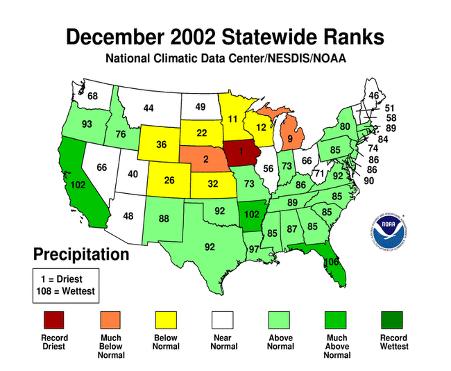
December Precipitation
larger imageThe graph to the left is a time series depicting precipitation averaged across the contiguous U.S. Based upon preliminary precipitation data, December 2002 was much wetter than average, ranking 9th wettest - only the second significantly wetter than average month in the last two and a half years . There has been no significant trend in mean national December precipitation over the last century.
There was considerable regional variability in precipitation across the country. Three states in the southern half of the country (California, Arkansas and Florida), received much above average rainfall in December, while 2 states (Michigan, and Nebraska) received much below average rainfall this month. Iowa had its driest December on record. This follows on the heels of a dry November for the Middle and Upper Mississippi Valley, and combined rankings for the last 2 months show that Nebraska and South Dakota were the driest such 2 months on record and that the East North Central Region was much drier than average. Sustained drought alleviation continued in many eastern states and the long-term drought in much of the east is now over. Some long-term dryness still remains from Georgia to Virginia, however this is no longer severe and is expected to dissipate with El Nino-related precipitation continuing to be above normal in the Southeast. larger image
Some precipitation fell as snow in December, especially in the New England region and along the east coast. More details of snowfall in December can be found on the snow season page
Thunderstorms Produce Severe Weather in Missouri
Thunderstorms preceding a strong cold front pushed into the U.S. Mississippi Valley on the 17th, producing severe weather and tornadoes. Three people were killed in Missouri and Arkansas with more than 40 injuries (Associated Press).
A powerful Pacific storm system plowed into the western United States during the 13th-16th, producing high winds, heavy rains, significant mountain snowfall and causing 9 deaths (Associated Press). Rainfall amounts exceeding 254 mm (10 inches) occurred in parts of California, and wind gusts over 70 km/hr (~40 knots or 45 mph) produced up to 1.9 million power outages during the period (Pacific Gas & Electric).

 larger
image
larger
image| Region | Rank |
|---|---|
| Northeast | 79th driest/ 30th wettest |
| East North Central | 4th driest/ 105th wettest |
| Central | 77th driest/ 32nd wettest |
| Southeast | 100th driest/ 9th wettest |
| West North Central | 23rd driest/ 86th wettest |
| South | 97th driest/ 12th wettest |
| Southwest | 55th driest/ 54th wettest |
| Northwest | 80th driest/ 29th wettest |
| West | 98th driest/ 11th wettest |
 larger image |
The graph to the left is a time series depicting precipitation from October-December averaged across the primary hard red winter wheat belt. The growing season runs from October to February for the hard red winter wheat and preliminary data indicate that precipitation was above average for the first 3 months of the growing season in 2002. |
Precipitation Departures
The map below, based on more than 500 airport stations, shows December 2002 total precipitation as a percent of the 1971-2000 station normals. Above normal precipitation generally occurred in the West, Gulf states and along the east coast. The north central part of the country was anomalously dry as well as Alaska, Hawaii and parts of the Southwest U.S.
A large storm system impacted the west coast during the 13th-16th December 2002 and caused many 24-hour rainfall records to fall, especially in California. San Francisco airport received 2 consecutive 24-hour rainfall record totals on the 13th and 14th of December. On the 13th, 2.47 inches of rain smashed the old record of 0.45 inches set in 1968, and on the 14th 0.88 inches exceeded the old record by 0.05 inches. Contrasting the heavy precipitation in the west, parts of the Midwest set new records for dryness. In Des Moines, Iowa, 53 consecutive days without rain (ending on January 4th, 2003) broke the old record for the number of dry days (45). And in Kansas City, MO, the record for the driest December was equalled with a total of only 0.03 inches of rainfall during the month. For more records during December 2002, see NCDC's Extremes Page.
larger image

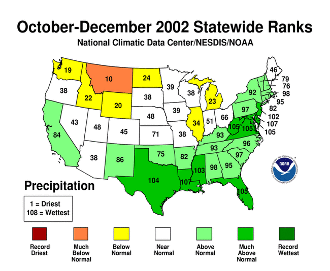
Three months, October-December 2002
larger imageThe graph to the left is a time series depicting precipitation averaged across the contiguous U.S. Based upon preliminary precipitation data, October-December 2002 was much wetter than average, ranking 11th wettest in the last 108 years. This belies considerable regional variability as can be seen from the maps below and contrasts with the last 3 October-December periods.
larger image
larger image
Nine states along the Gulf coast and eastern seaboard received much above average precipitation over October-December 2002. Several divisions had record precipitation totals for the period. Montana was the only state to average much below normal precipitation for the three months though general dryness was seen throughout the Northwest, North Central and Central regions and also portions of the Great Lakes.

 larger
image
larger
image
National Precipitation - January-December 2002
A comprehensive annual assessment of the U.S. climate is available in preliminary form and will be in final form on January 23rd.
larger imageThe graph to the left is a time series depicting precipitation averaged across the contiguous U.S. Based upon preliminary precipitation data, January-December 2002 was slightly drier than average, ranking 41st driest in the last 108 such periods. The last 4 years have averaged slightly to much below the long term mean precipitation.
Record dryness occurred in Colorado from January to December, 2002. The pattern of state-averaged annual precipitation can be seen in the map to the right. Five other states ranked in the top ten driest such periods. More information on drought analysis for these states and others can be found on NCDC's Drought Pages. Mississippi and West Virginia had their 11th wettest year on record while New York state had its 12th. Much of the annual precipitation along the Gulf coast and eastern states fell in the second half of the year.
larger image

