
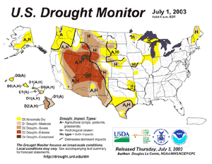
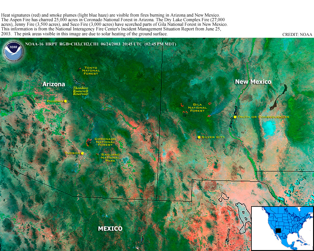
| Much above normal
temperatures and drier weather maintained severe to extreme drought
conditions throughout much of the Rockies during June 2003.
Wildfire
activity increased by the end of June, especially through
drought areas of the Southwest. |
larger
image
|
For complete drought information for the United States, please
see the U.S. drought
pages.
 larger
image
larger
image
|
A 20-day heat wave in
southern India continued into early June, with maximum temperatures
reaching as high as 45-50°C (113-122°F). More than 1,500
deaths were reported in India, with the southeastern state of
Andhra Pradesh the hardest hit (BBC News/Associated Press). In
neighboring Pakistan, the city of Jacobabad reached 52°C
(126°F) on the 5th; normal highs in early June are near
44°C (111°F). Hot temperatures exacerbated drought
conditions in the region, with a later-than-normal onset of summer
monsoon rainfall. |

| In Venezuela, heavy
rains caused flooding which killed 16 people and forced the
evacuation of 450 others in the southwestern state of Merida
(Associated Press). The flooding and mudslides occurred near the
mountainous border with Colombia, about 600 km (360 miles) west of
the capital city of Caracas. Flash flooding is common during the
rainy season in Venezuela, which runs from mid-May through
November. |

larger
image
|
More flooding affected parts of Colombia around the 15th,
causing 5 deaths and rendering 4,000 people homeless
(Disasterrelief.org).
 larger
image
larger
image
|
Flooding in Bangladesh
affected the Khowai and Dhalai rivers, stranding nearly 50,000
people in the northeastern part of the country. The most severe
flooding occurred in an area located 160 km (100 miles) northeast
of the capital city of Dhaka (Associated Press). On June 27, a
landslide in the Chittagong district of Bangladesh killed 65 people
(Reuters/IFRC). The onset of monsoon rains by mid-month also
produced flooding in the adjacent northeast Indian state of Assam.
The Indian government deployed army units to the region as flooding
left around 440,000 homeless (OCHA/Reuters.) |
Flooding from Typhoon
Soudelor impacted the northern Philippines during June 14-17,
causing 11 deaths (OCHA). More heavy rains impacted parts of Japan
and South Korea as the storm accelerated northward and weakened by
the 19th.
| In the United States,
heavy rainfall occurred in areas of the central and southern
Appalachians, with 7 deaths attributed to flooding in Kentucky,
West Virginia and North Carolina (Associated Press). Rainfall
during June 13-19 locally exceeded 125 mm (5 inches) in some
areas. |

larger
image
|
Rainfall in the Northeast was much above normal during June. In
New York City, over 250 mm (~10 inches) of rain fell at Central
Park during the month, breaking the old June monthly rainfall
record of 248 mm (9.78 inches) set in 1903.
For an archive of flood events worldwide, see the
Dartmouth Flood Observatory.

 larger
image
larger
image
|
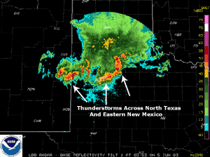
Severe thunderstorms
produced hail and wind damage, along with several
tornadoes, over parts of west Texas and extreme eastern New
Mexico late on the 4th. |
| More severe weather
occurred in southeastern Nebraska and northern Kansas on the 22nd.
A tornado was responsible for one fatality near Deshler, Nebraska.
This was the first tornado death in Nebraska since 1988 (Associated
Press). |
Radar Animation (Courtesy UCAR) |
This was the largest hailstone ever recorded in the state of
Nebraska, and may be the largest hailstone ever documented in the
U.S. and globally. The existing record is held by the Coffeyville,
Kansas hailstone (September 3, 1970) which weighed 1.67 pounds
(0.76 kg) and had a circumference of 17.5 inches (44.5cm). This
hailstone assessment is ongoing and a final decision will be made
in the coming months.
Severe thunderstorms in Bangladesh on the 7th and 10th resulted
in 6 fatalities. A tornado injured about 100 people on the 7th as
it affected the farming district of Noakhali, located 120 km (75
miles) east of Dhaka (Associated Press).

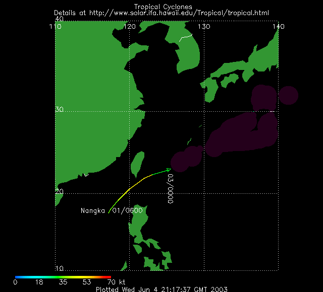
| Tropical Storm
Nangka
developed in the South China Sea on the 1st and passed just south
of Taiwan on the 2nd before dissipating by the 3rd. Locally heavy
rains and gusty winds affected southern areas of Taiwan and
adjacent areas of the northern Philippines as the storm moved
through the Luzon Strait. |

larger
image
|
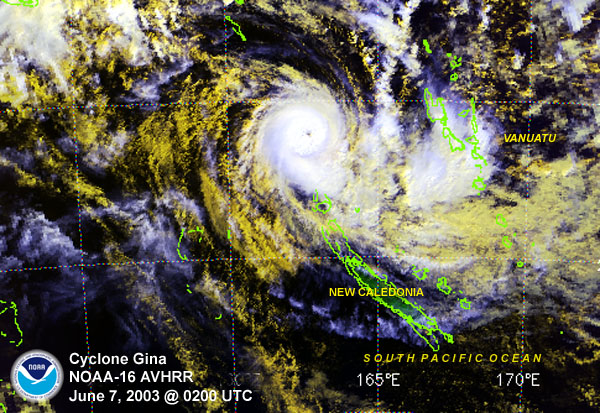
| Tropical Cyclone
Gina
developed in the South Pacific Ocean on the 4th and passed 60 km
(45 miles) west of Tikopia in the Solomon Islands on June 7,
affecting the island with winds up to 100 km/hr (55 knots or 60
mph) along with torrential rains. |

larger
image
|
 larger
image
larger
image
|
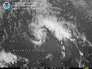
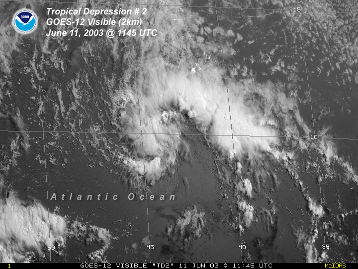
Tropical Depression #2
formed about 1,990 km (1,235 miles) east of the Windward Islands on
the 10th. The depression dissipated over open Atlantic waters on
the 12th. Climatologically, this is only the third tropical
depression since 1967 to form east of the Lesser Antilles in
June. |
| Typhoon Soudelor
developed in the western Pacific Ocean on the 11th and attained
typhoon strength by the 16th. The storm brought excessive
rains to parts of the Philippines, before moving into the East
China Sea by the 17th. While over open waters on the 18th, maximum
sustained winds peaked at 215 km/hr (115 knots or 130 mph).
Soudelor weakened as it recurved into the Sea of Japan, bringing
locally heavy rains to parts of Japan and South Korea by the
18th-19th. In Japan, there were 21 injuries attributed to the
storm, and nearly 10,000 homes were left without electricity
(Associated Press). |

larger
image
|
 larger
image
larger
image
|
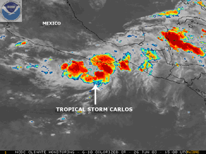
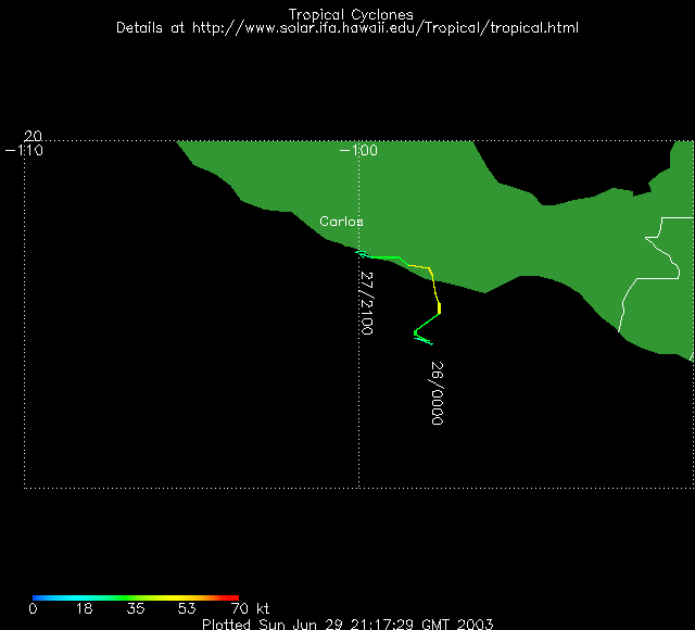
Tropical Storm
Carlos
developed in the eastern Pacific Ocean on the 25th about 320 km
(200 miles) south-southeast of Acapulco. Carlos made landfall along
the Mexican coast near near Puerto Escondido on the 27th with
maxiumum sustained winds near 100 km/hr (55 knots or 65 mph). After
making landfall, Carlos quickly dissipated, but produced locally
heavy rainfall over coastal areas. |
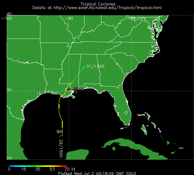
| Tropical Storm
Bill
developed in the central Gulf of Mexico on the 29th. Bill made
landfall along the
coast of Louisiana on the 30th in Terrebonne Bay about 50 km
(30 miles) east of Morgan City with maximum sustained winds at the
time of landfall near 95 km/hr (60 mph). The storm caused power
outages to around 220,000 homes and businesses in southeastern
Louisiana (Associated Press). |

Click For Radar Animation |

| A rare June snow fell
in Moscow on the 4th, although warm ground temperatures prevented
any accumulation. This was the first June snowfall in Moscow since
1963 (ROSHYDROMET). Unusually cool temperatures were observed
throughout much of western Russia on the 4th. |

larger
image
|
References:
Basist, A., N.C. Grody, T.C. Peterson and C.N. Williams, 1998:
Using the Special Sensor Microwave/Imager to Monitor Land Surface
Temperatures, Wetness, and Snow Cover. Journal of Applied
Meteorology, 37, 888-911.
Peterson, Thomas C. and Russell S. Vose, 1997: An overview of
the Global Historical Climatology Network temperature data base.
Bulletin of the American Meteorological Society,
78, 2837-2849.
|

 South Asia Heat In June


