|
Contents Of This Report: |
|
National Drought Overview
|
|
[top]
Detailed Drought Discussion
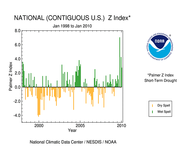
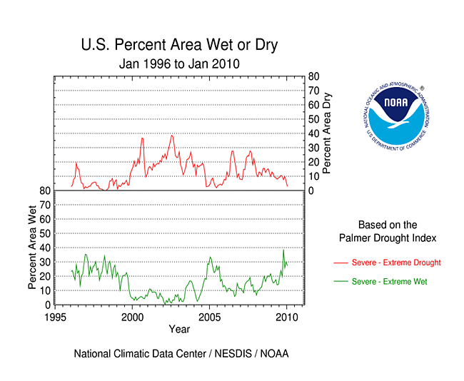
January 2010 was an average month when weather conditions are averaged across the country, with the national precipitation and temperature ranking near the middle of the historical distribution. But considerable variability occurred throughout the month and on a regional basis. Beneficial rain and snow – over the drought areas of southern Texas and much of the West – shrank drought to its smallest national footprint in a decade. In contrast, the month was drier than normal across parts of the central Plains to central Rockies, Lower Mississippi River Valley, and Northeast, and much of the Great Lakes, Ohio Valley, Alaska, and Hawaii. By the end of January, moderate to severe drought persisted across parts of the West, South Texas, and northern Wisconsin, and moderate to extreme drought was entrenched over parts of Hawaii.

The U.S. Drought Monitor drought map valid February 2nd, 2010.
January's  weather pattern was dominated by a series of winter storms generated by the subtropical jet and polar jet. The subtropical jet channeled Pacific low pressure systems into the West and developed new low pressure systems along the Gulf Coast states. The lows picked up abundant moisture from the Gulf of Mexico and intensified as they moved east and up the Atlantic Coast. The polar jet funneled cold arctic air masses into the Lower 48 States. The arctic air, in conjunction with moist Gulf weather systems, helped intensify the winter storms which produced extensive areas of snow and heavy rain.
By the end of January, core drought areas in the U.S. included:
- parts of Hawaii, where moderate (D1) to extreme (D3) drought persisted (Hawaii had the most severe drought in the nation at the end of the month); and
- parts of the West, Upper Mississippi Valley, and southern Texas, which had areas of moderate (D1) to severe (D2) drought.
 |
 |
 |
Precipitation over southern Texas during the last six months has significantly reduced the drought area, but deficits were still evident at the 24-month time scale. Dryness in the northwestern U.S. is evident for the last one to six months and, for some areas, for most of the last two years. The central High Plains to central Rockies were dry in January and at the 3-month time scale, but wet at the longer time scales. Parts of the Great Lakes to Ohio Valley were significantly dry in January and at the 3-month time scale, with a few areas showing dryness at longer time scales. The heavy precipitation in January greatly benefited the southwestern U.S., but it was not enough to eliminate long-term deficits at the 24-month time scale.
 |
 |
 |
Did You Know?
Definition of Drought

Drought is a complex phenomenon which is difficult to monitor and define. Hurricanes, for example, have a definite beginning and end and can easily be seen as they develop and move. Drought, on the other hand, is the absence of water. It is a creeping phenomenon that slowly sneaks up and impacts many sectors of the economy, and operates on many different time scales. As a result, the climatological community has defined four types of drought: 1) meteorological drought, 2) hydrological drought, 3) agricultural drought, and 4) socioeconomic drought. Meteorological drought happens when dry weather patterns dominate an area. Hydrological drought occurs when low water supply becomes evident, especially in streams, reservoirs, and groundwater levels, usually after many months of meteorological drought. Agricultural drought happens when crops become affected. And socioeconomic drought relates the supply and demand of various commodities to drought. Meteorological drought can begin and end rapidly, while hydrological drought takes much longer to develop and then recover. Many different indices have been developed over the decades to measure drought in these various sectors. The U.S. Drought Monitor depicts drought integrated across all time scales and differentiates between agricultural and hydrological impacts.
The drought situation in Hawaii deteriorated as the percent area of extreme drought (D3) grew from 5 percent of the islands at the end of December to 13 percent at the end of January. The area experiencing moderate (D1) to extreme (D3) drought expanded from 53 percent to 77 percent. January continued a trend of drier-than-normal weather which has lasted for at least the last three to 12 months. Streamflow averaged below normal. Most stations in Alaska, especially at interior locations, have been drier than normal for January and the last three to at least 12 months. Abnormally dry conditions (D0 on the USDM) expanded during the month further into central Alaska where end-of-January snowpack and snow water equivalent percentages continued to be low. January was wet along the northern coast of Puerto Rico but dry in southern areas. Much of the eastern half of the island has had below-normal rainfall for the last six months.
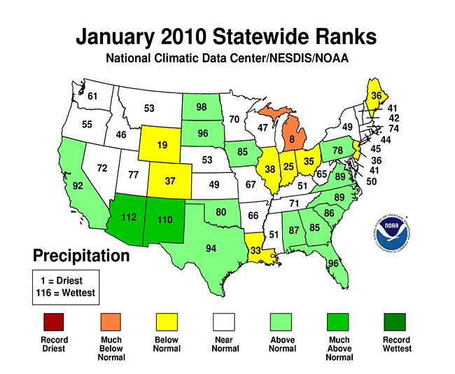
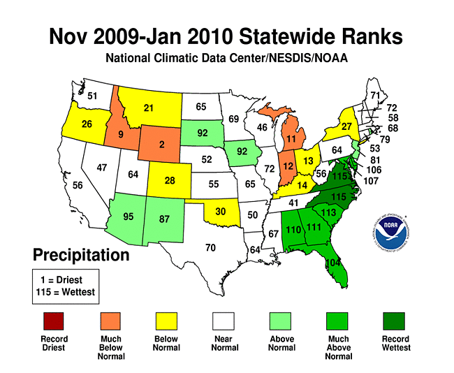
On a statewide basis, Michigan ranked eighth driest for January precipitation. For November-January, Wyoming ranked second driest, Idaho ninth driest, Michigan eleventh driest, and Indiana twelfth driest.
Abnormal dryness and drought were evident in several indicators. The central Plains to central Rockies, and parts of the northern Great Lakes, had just a few days with precipitation during January. The dryness in the central High Plains to central Rockies lasted three consecutive weeks or longer. Soil moisture, as monitored by several models (NOAA Climate Prediction Center anomalies and percentiles, NLDAS [North American Land Data Assimilation System] top soil layer and total soil layers, Leaky Bucket), was drier than average across parts of the West, southern Plains, Great Lakes, Alaska, and Hawaii. Well monitoring stations had sporadic reports of low groundwater in the West, Upper Midwest, and even parts of the East. Below-normal streamflow was measured across Hawaii and parts of the western Great Lakes and intermountain basin. Satellite monitoring of vegetation health (Vegetation Drought Response Index, Vegetation Health Index) indicated lingering stress on vegetation in the Southwest.
October through the following September is defined as the water year for the West. Water-year-to-date (October-January) precipitation has been mixed, with above-average conditions dominating in the south and below-average conditions more common in the north. This pattern was more evident in the high-elevation station (SNOTEL) network, especially in maps of the end-of-January snowpack and snow water content. The snow water equivalent at some high elevation remote stations in the central Rockies and Northwest ranked in the driest fifth percentile. Winter and spring mountain snowpack provides a crucial water source for the summer melt season across much of the West. An analysis by the U.S. Department of Agriculture (USDA) indicated that reservoir levels were generally below average aross the Northwest to interior basins. According to the USDM, 19 percent of the West was experiencing moderate to severe drought at the end of January, which was a considerable improvement over December, while the Palmer Drought Index statistic was also 19 percent.
As explained by the Midwest Regional Climate Center, January precipitation varied across the Midwest. Areas receiving less than half their normal (1971-2000 normal) precipitation included east central Wisconsin, most of Lower Michigan, northeast Indiana, and northwest Ohio. Areas receiving more than 150 percent of normal included south central Missouri, southern and western Iowa, and the western edge of Minnesota. January snow was above normal in northwest and central Iowa, southern Missouri to Kentucky, northwest Indiana, and northeast Ohio. Parts of Kentucky and Missouri received twice their normal snowfall during the month. The rest of the Midwest received less than normal snow amounts with a swath across Minnesota, Wisconsin, and Michigan under 50 percent of normal. Long-term drought continued in northwest Wisconsin, extending slightly into Minnesota and Upper Michigan. There was slight improvement during the month as the areas of severe and moderate drought shrunk a bit.
As noted by the Southeast Regional Climate Center, in contrast to the wet December, precipitation totals for January 2010 were much closer to normal across the Southeast region. Dry conditions were especially prevalent during the first half of the month as continental polar air dominated the region. Monthly precipitation totals were less than 50 percent of normal across local portions of South Florida, far southwestern Virginia, central South Carolina and southeastern North Carolina. On the other hand, Crestview, Florida and Plains, Georgia recorded 13.14 inches and 10.50 inches (334 and 267 mm) of precipitation, respectively, for the month. Most of the precipitation fell during the latter half of the month as the wet December pattern associated with El Niño conditions in the equatorial Pacific returned. Precipitation totals for January were more than 200 percent of normal across the northern portions of Puerto Rico. The small region of abnormal dryness (D0) in South-Central Florida disappeared during the month, marking the first time that the region was drought free since August 23rd, 2005.
As summarized by the Northeast Regional Climate Center, precipitation totals averaged below normal this month. The region's average of 2.85 inches (72.4 mm) was 85 percent of the normal January amount. Connecticut and New Jersey were the driest states, each with 65 percent of normal precipitation. Pennsylvania (103 percent of normal) and West Virginia (106 percent of normal) were the only states with precipitation totals that were above normal.
As explained by the High Plains Regional Climate Center, precipitation varied widely across the High Plains Region this month. Many locations across the Dakotas had precipitation totals that were up to 400 percent of normal, whereas a large swath of Wyoming, Nebraska, Colorado, and Kansas received less than 25 percent of normal precipitation. Certain pockets of these states received less than 5 percent of normal precipitation. There were big changes to the U.S. Drought Monitor for the region this month. North Dakota joined South Dakota, Nebraska, and Kansas as the drought free states in the region. After heavy rains, a large portion of southwestern Colorado was downgraded from moderate drought (D1) to abnormally dry (D0) conditions. However, D0 spread into northwest and north-central Colorado and also western Wyoming. In addition, far western Wyoming slipped from D0 to D1.
As noted by the Southern Regional Climate Center, January monthly precipitation totals varied spatially over the Southern Region. Western and central Texas were the wettest areas of the region. In contrast, precipitation totals varied between 25 and 75 percent of normal in eastern Texas and throughout most of Louisiana. South-central Louisiana was the driest area of the region with most stations reporting only 25 to 50 percent of the monthly normal. As was the case in December, this month the states of Oklahoma, Arkansas, Tennessee, Louisiana and Mississippi remained drought free. Anomalously high monthly precipitation totals in west and southern Texas led to a slight improvement in drought conditions in the state. As of February 2, 2010, only a small area of Texas exhibited severe drought conditions. The drought was centered about Kinney and Maverick counties and was surrounded by a small area of moderate drought. A second area of moderate drought was located in the south of Texas. In total, only 1.2 percent of the state was in severe drought, with only 3.5 percent of the state in moderate drought conditions.
As summarized by the Western Regional Climate Center, precipitation was well above normal in the Southwest but extremely dry in most of Wyoming and eastern Colorado, and other mountain locations in the northern West. The pattern of much heavier precipitation in the southern (compared with the northern) West is very characteristic of El Niño years. Mountain snowpack increased significantly in the Sierra Nevada of California, going from 75 percent of normal early in the month to 100 percent by the end. In Arizona, mountain snowpack ranged anywhere from 185 percent to 300 percent of normal by month's end. The rest of the West (except southern Utah, southwest Colorado, and New Mexico) was below to well below normal (60 percent to 90 percent) by the end of January. The winter accumulation season was more than half over in many places, and concerns were rising about potentially deficient spring snowmelt runoff and summer water supplies.
According to media reports, drought plagued most of the Hawaiian Islands. Oahu was the only island without a drought designation. Pasture and general vegetation conditions were very poor in many areas of the western and southern sections of the Big Island, and were vulnerable to brushfires. Recent fires in the South Kona district highlighted the enhanced risk. Residents dependent on rainwater catchment, including those in the normally wet windward slopes, have been increasing water hauling requests to satisfy basic needs. Pastures and other vegetation were in a "highly degraded state" across western Maui and western Molokai. The National Weather Service noted that the winter storms, which usually bring rain, were being hampered by a peaking El Niño and were creating dry conditions across Hawaii (Hawaii Tribune-Herald, 2/8).
[top]
State/Regional/National Moisture Status
A detailed review of drought and moisture conditions is available for all contiguous U.S. states, the nine standard regions, and the nation (contiguous U.S.):
| northeast u. s. | east north central u. s. | central u. s. |
| southeast u. s. | west north central u. s. | south u. s. |
| southwest u. s. | northwest u. s. | west u. s. |
| Contiguous United States |
[top]
Drought Indicators
- Palmer Drought Indices
- Standardized Precipitation Index
- long-term (36 to 60 month) percent of normal precipitation maps
- airport station percent of normal precipitation maps
- statewide precipitation rank maps
- Cooperative station percent of normal precipitation maps
- percent of average maps for the SNOTEL stations in the western mountains provided by the Western Regional Climate Center
- hydrologic year precipitation
- snow water equivalent of snowpack
- satellite-based observations of vegetative health
- National Weather Service model calculations of soil moisture, runoff, and evaporation
- National Weather Service model calculations of soil moisture using the Leaky Bucket Model
- Midwest Regional Climate Center model calculations of soil moisture
- topsoil moisture conditions observed by the USDA and mapped by the Climate Prediction Center
- pasture and range land conditions observed by the USDA and mapped by the Climate Prediction Center
- streamflow maps maintained by the USGS
[top]
Contacts & Questions