National Overview:
- Temperature Highlights - January
- The
 January 2010 temperature for the contiguous United States was 31.1 degrees F, which is 0.3 degreesabove the long-term average.
 - The cold arctic air that dominated the contiguous U.S. in late 2009 moderated by the middle of January, creating a nationally-averaged temperature that was near the January long-term mean.
- The prevailing upper-level pattern held temperatures below normal in the Central, South, and Southeast
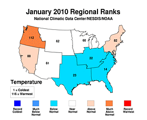 climate regions. Meanwhile, the Northwest climate region experienced its fifth warmest January on record. The West and Northeast regions were also above normal in terms of average temperature.
 - The western ridge and eastern trough pattern was well defined on the
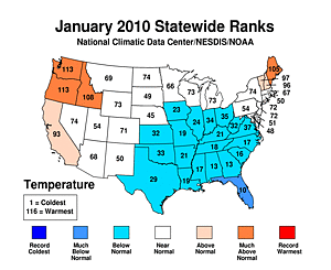 state level, where temperatures were much above normal in Washington and Oregon; each experiencing their fourth warmest January. Idaho and Maine also observed much above normal temperatures. Conversely, a vast area east of the Rocky Mountains were below normal in terms of temperature. Florida had its tenth coolest January, the third consecutive below normal January for the state.
 - Based on NOAA's Residential Energy Demand Temperature Index (REDTI), the contiguous U.S. temperature-related energy demand was 1.3 percent above average for January.
- Precipitation Highlights - January
 January precipitation, averaged across the contiguous U.S., was slightly above the long-term mean, at 2.42 inches.
-
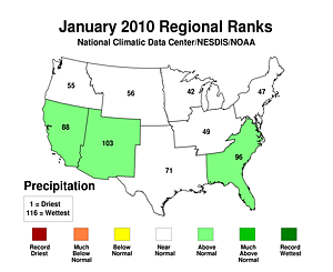 Regionally, the Southeast, Southwest, and West experienced above normal precipitation for the month. Each of the six remaining climate regions had a near-normal January.
 - On the
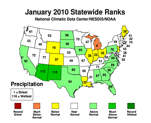 statewide level, substantial rain and snow in the southwest states of New Mexico and Arizona helped alleviate long-term precipitation deficits, and greatly reduced drought conditions.
 Arizona's 3.26 inches of precipitation represented its fifth wettest January, and
 New Mexico's averaged of 1.26 inches was its seventh wettest. Conversely,
 Michigan experienced its eighth driest January on record.
 - The
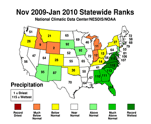 past three month period was anomalously wet for the Southeast. Both
  North Carolina and
  Virginia experienced their wettest November-January on record. Much above normal precipitation also fell in South Carolina, which experienced its third wettest, Georgia's (5th), Alabama's (6th), and Maryland's (9th) wettest such periods. On the flip-side,
  Wyoming experienced its second driest and it was
  Idaho's ninth driest such period on record.
 - Record wetness occurred in several states during the
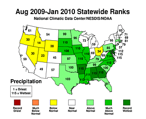 six-month period of August-January.
 Delaware,
 Maryland,
 Georgia,
 Alabama, and
 Arkansas all had their wettest such period. In addition, ten other states averaged much above normal precipitation that ranked in the top eight since record keeping began.
 - The extreme wetness can be traced back to the
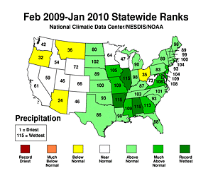 12-month period of February 2009 through January 2010. On this time frame,
 Illinois,
 Arkansas, and
 Alabama each experienced record wetness. The nation as a whole had its ninth wettest such period.
 - Other Items of Note
- An intense extra-tropical cyclone with heavy precipitation and hurricane force winds hit the west coast on the 21st and 22nd, setting record low barometric pressures from Oregon to Arizona. The pressure in Eureka, CA dropped to 978 mb, breaking the previous record set in 1891. Los Angeles, San Diego, Salt Lake City, Las Vegas, and Phoenix all broke low pressure records during the storm.
- A large winter storm brought significant snow and ice to the southern U.S. on the 28th through 30th, affecting the busy Interstate 40 corridor from New Mexico to the Atlantic Coast. Vast stretches of the interstate were forced to close, impacting commerce. Reports of snowfall over 10 inches and ice over 1 inch were widespread.
- By month's end, moderate-to-exceptional drought covered only 8.5 percent of the contiguous United States. This is the smallest drought footprint reported by the U.S. Drought Monitor since it became operational in 2000.
 January 2010 temperature
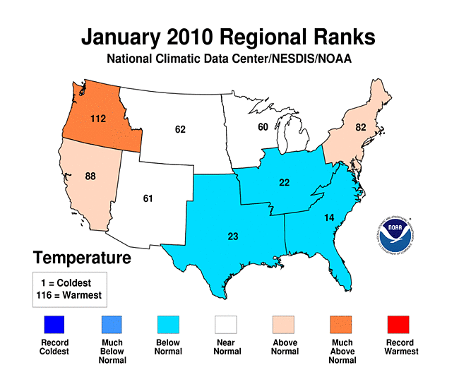 climate regions
 state level
 January precipitation
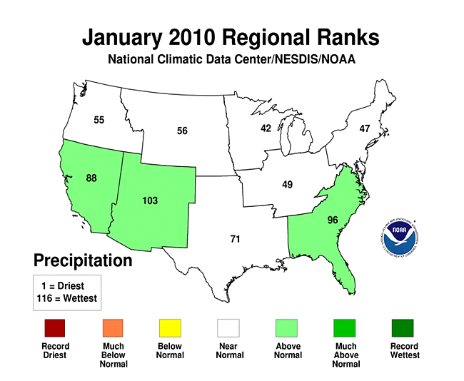 Regionally
 statewide level
 Arizona's 3.26 inches
 New Mexico's averaged of 1.26 inches
 Michigan
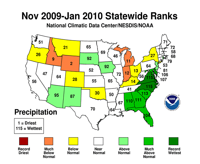 past three month
 North Carolina
 Virginia
 Wyoming
 Idaho's
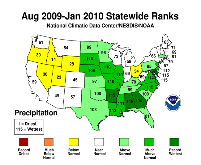 six-month period of August-January
 Delaware
 Maryland
 Georgia
 Alabama
 Arkansas
 12-month period of February 2009 through January 2010
 Illinois
 Arkansas
 Alabama
Beginning with January 2010 processing, the Alaska temperature and precipitation report is comprised of several datasets at NCDC, integrating GHCN and COOP datasets. Prior to 2010, the Alaskan temperature timeseries was processed with just GHCN data.
-
 Alaska
had its 46th coolest January since records began in 1918, with a
temperature 0.3°F (0.5°C) below the 1971–2000
average.
Alaska
had its 46th coolest January since records began in 1918, with a
temperature 0.3°F (0.5°C) below the 1971–2000
average.
-
 Alaska
had its 39th warmest November–January on record, with a
temperature 0.1°F (0.2°C) above the 1971–2000
average.
Alaska
had its 39th warmest November–January on record, with a
temperature 0.1°F (0.2°C) above the 1971–2000
average.
 Alaska
 Alaska
-
 Alaska
had its 3rd driest January since records began in 1918, with
an anomaly that was 54 percent below the 1971–2000
average.
Alaska
had its 3rd driest January since records began in 1918, with
an anomaly that was 54 percent below the 1971–2000
average.
-
 Alaska
had its 19th driest November–January on record, with
an anomaly that was 25 percent below the 1971–2000
average.
Alaska
had its 19th driest November–January on record, with
an anomaly that was 25 percent below the 1971–2000
average.
 Alaska
 Alaska
For additional details about recent temperatures and precipitation across the U.S., see the Regional Highlights section below. For information on local temperature and precipitation records during the month, please visit NCDC's Records page. For details and graphics on weather events across the U.S. and the globe please visit NCDC's Global Hazards page.
Regional Highlights:
These regional summaries were provided by the six Regional Climate Centers and reflect conditions in their respective regions. These six regions differ spatially from the nine climatic regions of the National Climatic Data Center.
- Northeast Region: (Information provided by the Northeast Regional Climate Center)
- After a cold start in most of the Northeast, temperatures during the second half of January moderated, yielding a monthly average that was 1.9 degrees F (1.1 degrees C) above normal. Strong southerly winds ahead of a powerful storm system on the 25th and 26th pushed readings to record highs in a few places before plummeting to normal or below normal readings for the end of the month. The Northeast's average January temperature of 24.9 degrees F (-3.9 degrees C) was 6.7 degrees F (3.7 degrees C) warmer than January 2009 but 2.0 degrees F (1.1 degrees C) cooler than the same month in 2008. There was quite a variance in temperature departures from north to south. Maine averaged 7.3 degrees F (4.1 degrees C) above normal, and experienced its 12th warmest January in 116 years. On the opposite end of the spectrum, the southernmost state, West Virginia, averaged 2.2 degrees F (1.2 degrees C) below normal.
- Precipitation totals averaged below normal this month. The region's average of 2.85 inches (72.4 mm) was 85% of the normal January amount. Connecticut and New Jersey were the driest states, each with 65 percent of normal precipitation. Pennsylvania (103 percent of normal) and West Virginia (106 percent of normal) were the only states with precipitation totals that were above normal. There were no large scale snow events this month, but persistent lake effect snows early in the month and a system that dumped up to 10 inches (25.4 m) of the white stuff on southern Delaware, Maryland and West Virginia on the 30th and 31st resulted in near normal totals in most of the region.
- For more information, please go to the Northeast Regional Climate Center Home Page.
- Midwest Region: (Information provided by the Midwest Regional Climate Center)
- January temperature departures from normal ranged from +5 degrees F (+3 degreesC) in the upper Midwest to -7 degrees F (-4 degrees C) in western Iowa. Michigan and Wisconsin were near to above normal while Iowa, Missouri, Illinois, Indiana, Ohio, and Kentucky were near to below normal. Minnesota was split with above normal temperatures in the north and below normal in the south. Temperatures were well below normal across the Midwest for the first 10 days of the month, followed by a warming that led to much above normal temperatures in week three, and then a return to below normal temperatures for the last week of January.
- January precipitation varied across the Midwest. Areas receiving less than half their normal precipitation included east central Wisconsin, most of lower Michigan, northeast Indiana, and northwest Ohio. Areas receiving more than 150 percent of normal included south central Missouri, southern and western Iowa, and the western edge of Minnesota. January snow was above normal in northwest and central Iowa, southern Missouri to Kentucky, northwest Indiana, and northeast Ohio. Parts of Kentucky and Missouri received twice their normal snowfall during the month. The rest of the Midwest received less than normal snow amounts with a swath across Minnesota, Wisconsin, and Michigan under 50 percent of normal.
- On the 20th and 21st an ice storm extended from Iowa to Ohio. Iowa was hardest hit with widespread ice accumulations of around 0.5 inches (1.3 cm) causing multi-day power outages and school closings. Ice was blamed for numerous auto accidents across the affected parts of the Midwest even where there were lesser accumulations.
- On the 20th and 21st an ice storm extended from Iowa to Ohio. Iowa was hardest hit with widespread ice accumulations of around 0.5 inches (1.3 cm) causing multi-day power outages and school closings. Ice was blamed for numerous auto accidents across the affected parts of the Midwest even where there were lesser accumulations.
- Snow cover was extensive at the beginning of the month with snow on the ground across the Midwest except Kentucky and southeast Missouri. By the 10th, snow extended across the entire region then warmer temperatures mid-month reduced the snow cover in the southern half of the region. Late in the month, a storm covered the southern extent of the region with snow leaving only a narrow swath in northern Missouri without some snow on the ground.
- Long-term drought continued in northwest Wisconsin, extending slightly into Minnesota and upper Michigan. There was slight improvement during the month as the areas of severe and moderate drought shrunk a bit.
- Ice jams on rivers in southern Wisconsin, northern Illinois, eastern Iowa, and northwest Missouri caused localized, but rapidly changing flood conditions early in the month. Heavy rain and snowmelt on the 24th pushed rivers above flood stage in Iowa, Missouri, Illinois, and Indiana.
- For details on the weather and climate events of the Midwest, see the weekly summaries in the MRCC Midwest Climate Watch page.
- Southeast Region: (Information provided by the Southeast Regional Climate Center)
- Monthly average temperatures for January 2010 were below normal across the entire region, except for small portions of eastern VA. Temperatures were more than 4 degrees F (2.2 degrees C) below normal over much of South Carolina, Georgia, Alabama, and Florida. Temperatures were especially cold during the first half of the month as a succession of very cold air masses was advected southeastward into the region. More than 300 daily minimum temperature records were recorded, with more than two-thirds of these observed in Florida. Temperature departures from normal were especially notable during the daytime as records were slashed for daily low maximum temperatures at nearly 500 stations. The duration of the cold conditions was especially noteworthy. In Daytona Beach, temperatures did not exceed 60 degrees F (15.5 C) for a 12 day period. In fact, records were broken or tied at Daytona Beach, Orlando, Melbourne, and Vero Beach Florida for the greatest number of consecutive days in which the daily high temperature remained below 60 degrees F (15.5 C). There were only 39 daily maximum record temperatures recorded during the month. The warmest temperatures occurred between the 18th and 25th of the month at most locations. Waycross, Georgia and Andrews, South Carolina recorded a daily maximum of 78 and 74 degrees F (25.6 and 23.3 degrees C), respectively, during this period. In Puerto Rico most stations report monthly average temperatures that were close to normal.
- In contrast to the wet December, precipitation totals for January 2010 were much closer to normal. Dry conditions were especially prevalent during the first half of the month as continental polar air dominated the region. Monthly precipitation totals were less than 50% of normal across local portions of South Florida, far southwestern Virginia, central South Carolina and southeastern North Carolina. Greenwood, SC recorded 1.02 inches (26 mm) of precipitation for the month, which was only 20 percent of normal precipitation for January. Precipitation totals exceeded 150 percent of normal across portions of South Central Georgia, the northern half of Florida and small portions of the western Carolinas and Virginia. Crestview, FL and Plains, GA recorded 13.14 inches and 10.50 inches (334 and 267 mm) of precipitation, respectively, for the month. Most of the precipitation fell during the latter half of the month as the wet December pattern associated with El Nino conditions in the equatorial Pacific returned. Crestview, Florida recorded 6.98 inches (177 mm) of precipitation on the 21st of the month. Also, Montebello, VA recorded 5.63 inches (143 mm) on the 25th of the month, which broke the record for the heaviest precipitation for the month of January. Precipitation totals for January were more than 200 percent of normal across the northern portions of Puerto Rico. San Juan recorded 6.07 inches (154 mm) of precipitation on the 14th and 15th of the month. This was the heaviest 2-day precipitation total observed for the month of January in a record extending back to 1956.
- The small region of abnormal dryness (D0) in South-Central Florida disappeared during the month marking the first time that the region was drought free since August 23rd, 2005.
- Seven tornadoes, most of them relatively weak, were reported across portions of Georgia, Alabama and Florida during the latter half of the month. An EF-2 tornado touched down in Huntsville, AL on the 21st of the month injuring 3 people. Thunderstorms produced widespread strong winds of 50 to 70 MPH from northern Florida to the eastern Carolinas on the 24th of the month.
- Heavy snowfall was observed across the northern portion of the region on the 29th and 30th of the month as a cyclone moved east-northeastward from the Texas coast to the Georgia coast. Snowfall totals of 8 to 12 inches (203-305 mm) were observed across much of Virginia as well as the northern and western portions of North Carolina. By the end of January, Asheville, North Carolina had already received nearly 24 inches (610 mm) of snowfall for the season, which makes it the heaviest early season snowfall total in a record that extends back to 1902. The unusually cold conditions in Florida were accompanied by snow flurries in Orlando, Florida on the 9th of the month.
- The extended period of low temperatures across the region greatly increased heating demands during the month. Power companies in Georgia estimated that heating costs were about 30 percent above normal for the month and 60 percent above demands for last winter. In Florida farmers used irrigation over more than 140 hours to protect crops from the sub-freezing temperatures. This caused deep draw downs in the water table, which resulted in numerous dry wells. This also caused large sink holes to form that damaged homes and also closed numerous highways, including I-4.
- For more information, please go to the Southeast Regional Climate Center Home Page.
- High Plains Region: (Information provided by the High Plains Regional Climate Center)
- January 2010 started off with record cold, but most areas of the Region were between 2 degrees F (1.1 degrees C) above normal and 2 degrees F (1.1 degrees C) below normal by the end of the month. Exceptions were eastern sections of Kansas, South Dakota, and Nebraska which had temperature departures from 4 degrees F (2.2 degrees C) to 8 degrees F (4.4 degrees C) below normal. Meanwhile, northern North Dakota, portions of Wyoming, and pockets of Colorado had temperature departures up to 6 degrees F (3.3 degrees C) above normal and pockets of Wyoming had temperature departures of up to 8 degrees F (4.4 degrees C) above normal. Despite these large departures, temperature records were not broken this month. In many places, snow cover had quite an effect on the average temperatures this month. For instance, western Nebraska was free of snow and had temperature departures up to 4 degrees F (2.2 degrees C) above normal. Meanwhile, eastern Nebraska, where record snow depths occurred, had temperature departures up to 8 degrees F (4.4 degrees C) below normal.
- Precipitation varied widely across the Region this month. Many locations across the Dakotas had precipitation totals that were up to 400 percent of normal, whereas a large swath of Wyoming, Nebraska, Colorado, and Kansas received less than 25 percent of normal precipitation. Certain pockets of these states received less than 5 percent of normal precipitation. This month's wet location was Mission, South Dakota which received 1.57 inches (39.88 mm) of precipitation, or 476 percent of normal, which beat the old record of 1.13 inches (28.70 mm) recorded in 2001 (period of record 1967-2010). While no snowfall records were broken this month, several snow depth records were broken across eastern Nebraska. A few light snows combined with several December 2009 snow storms resulted in new January snow depth records. Norfolk, Nebraska crushed the old record of 17.0 inches (43.18 cm) recorded in 1969 (period of record 1899-2010). The record was initially broken on the first day of the month with 19.0 inches (48.26 cm) but snow continued to fall and the record 25.0 inches (63.50 cm) of snow on the ground was reached on January 10th. Omaha, Nebraska also beat out the old snow depth record of 14.0 inches (35.56 cm) recorded in 2005 with 21.0 inches (53.34 cm) recorded January 7th-10th (period of record 1948-2010). The big story this month was a winter storm which brought rain, freezing rain, snow, and blizzard conditions to portions of the Region. The January 23rd-25th storm started off as a mixture of precipitation before changing over to all snow in parts of the Dakotas. Heavy snow fell in North Dakota and snow reports of 6-10 inches (15.25-25.40 cm) were common. Towards the end of the storm, additional snow and strong gusting winds produced blizzard conditions for the eastern portions of the Dakotas and far northeastern Nebraska. Due to the blizzard conditions, visibility was greatly reduced and sections of I-29, I-94, and I-90 were closed. In addition, at least 10,000 people lost power from the storm.
- There were big changes to the U.S. Drought Monitor for the High Plains Region this month. North Dakota joined South Dakota, Nebraska, and Kansas as the drought free states in the Region. After heavy rains, a large portion of southwestern Colorado was downgraded from moderate drought (D1) to abnormally dry (D0) conditions. However, D0 spread into northwest and north-central Colorado and also western Wyoming. In addition, far western Wyoming slipped from D0 to D1. According to the U.S. Seasonal Drought Outlook released January 21st, the drought conditions in the southwest corner of Colorado and western Wyoming are expected to improve through April 2010.
- For more information, please go to the High Plains Regional Climate Center Home Page.
- Southern Region: (Information provided by the Southern Regional Climate Center)
- In accordance with what was observed in the preceding month, January mean monthly temperature averages were below normal over much of the Southern Region. In general, temperatures varied between 0 and 4 degrees F (0 and 2.2 degrees C) below normal. The highest negative temperature departures were observed in southern Mississippi and in southeastern Louisiana, where stations averaged anywhere from 4 to 6 degree F (2.2 to 3.3 degrees C) below the monthly normal. Low temperature averages were due in part to a deep trough, which pushed a continental polar air mass over much of the south. The trough held in place for several days, setting temperature records in all six states. In fact, from January 5 to January 14, 635 daily minimum temperature records were equaled or set in the Southern Region
- January monthly precipitation totals varied spatially over the Southern Region. Western and central Texas were the wettest areas of the region, with most stations reporting between 150 and 200 percent of the monthly normal. Similar values were also observed in north central Arkansas and in central Oklahoma. In central Texas, several stations reported values that exceeded 300 percent of normal for the month. In contrast, precipitation totals varied between 25 and 75 percent of normal in eastern Texas and throughout most of Louisiana. South central Louisiana was the driest area of the region with most stations reporting only 25 to 50 percent of the monthly normal. In total, Texas averaged 2.34 inches (59.44 mm) for the month, while Oklahoma averaged 1.67 inches (42.42 mm). In the central states of the Southern Region, Arkansas averaged 4.14 inches (105.16 mm) for the month and Louisiana averaged 3.42 inches (86.87 mm). In the remaining states, Tennessee averaged 5.00 inches (127.00 mm) while Mississippi averaged 4.64 inches (117.86 mm) for the month.
- As was the case in December, 2010, The states of Oklahoma, Arkansas, Tennessee, Louisiana and Mississippi remained drought free. Anomalously high monthly precipitation totals in west and southern Texas led to a slight improvement in drought conditions in the state. As of February 2, 2010, only a small area of Texas is exhibiting severe drought conditions. The drought is centered about Kinney and Maverick counties. It is surrounded by a small area of moderate drought. A second area of moderate drought is located in the south of Texas. In total, only 1.2 percent of the state is in severe drought, and only 3.5 percent of the state is experiencing moderate drought conditions.
- On January, 20, 2010, several tornadoes touched down, spanning an area from northeast Texas to west central Mississippi. In Evangeline Parish, Louisiana, it was reported that cars were blown into a ditch. In Harrison County, Texas, several homes and two businesses were reported to be damaged. One home was completely destroyed. In Smith Country, Texas, many roofs were damaged, with shingles and decking ripped off.
- January 16-23: Powerful storms in California and the Southwest: A series of strong storms hit the Southwest causing extensive damage and flooding throughout the region. The storm track was generally from northern California to southern California, across southern Nevada, Utah, and Colorado and most of Arizona and New Mexico. Rainfall totals exceeded 20 inches (508 mm) in the higher elevations of California for the week while snowfall totals were in excess of 90 inches (229 cm) around Mammoth Lakes, CA. Strong winds of up to 90 mph downed trees and led to the death of two people when trees fell on their homes. Over 23,000 customers in southern California were without power for a short time on the 18th while customers in Siskiyou County to the north were without power for up to 30 hours on the 20th from heavy, wet snow downing trees and power lines. Numerous debris flows occurred where heavy rain fell on the burned areas of southern California leading to evacuations for nearly 500 homes in the cities of La Canada and Flintridge on the 19th to the 20th. In Arizona, 50.7 inches (129 cm) of snow fell in Flagstaff for the third highest five-day total ever there. One child was swept to his death in Yavapai County when the family attempted to cross a flooded road. Near Wikieup, AZ, the Big Sandy River crested at 17.9 feet, washing away numerous roads and setting a new all-time record crest, breaking the previous record of 16.4 feet set back in March 1978. In Durango, CO, snow and debris were up to 12 feet deep closing local roads and highways.
- For more information, please go to the Southern Regional Climate Center Home Page.
- Western Region: (Information provided by the Western Regional Climate Center)
- Temperatures were mostly above normal around the West except for portions of the Four-Corner states and a few intermountain valley locations that were trapped in cold air from strong inversions. The Pacific Northwest was particularly mild. Spokane, Washington, had their 5th warmest January in 120 years while in Lewiston, Idaho, it was the 4th warmest January on record. Lewiston reported only 6 days with minimum temperatures below freezing. Seattle, Washington, reported its warmest January on record, including the airport (since 1948) and the downtown (since 1891) locations. Several nearby locations were 1st, 2nd, or 3rd warmest for January. This has caused concern for the nearby Winter Olympics in southwest Canada. Contrast that with Death Valley, California, which reported 5 days of freezing temperatures and an average monthly minimum temperature only 3 degrees F (1.7 C) warmer than Lewiston. Conversely, the average temperature at Moab Airport, Utah, was one of the coldest in the West at 14.6 F (-9.7 C), lower even than most locations in Montana and Wyoming. Grand Junction, Colorado, had its coldest January in 18 years. The temperature pattern was strikingly close to what is typically expected in an El Nino winter in the West.
- Precipitation was well above normal in the Southwest but extremely dry in most of Wyoming and eastern Colorado, and other mountain locations in the northern West. The Pacific Northwest was near to slightly above normal for the month. In a strange turn of events, Yuma, Arizona, reported 2 1/2 times as much rain as Hilo, Hawaii, for the month. Yuma's total of 2.44 inches (62 mm) was their 2nd greatest January total ever, narrowly missing the record of 2.49 (63 mm) set in 1949. Their daily total of 1.95 (50 mm) inches on the 21st was the greatest one-day January total ever. Las Vegas, Nevada, recorded their 5th wettest January on record dating back 115 years. Again the pattern of much heavier precipitation in the southern (compared with the northern) West is very characteristic of El Nino years.
- Mountain snowpack increased significantly in the Sierra Nevada of California, going from 75% of normal early in the month to 100 percent by the end. In Arizona, mountain snowpack ranged anywhere from 185 percent to 300 percent of normal by month's end. The rest of the West (except southern Utah, southwest Colorado, and New Mexico) was below to well below normal (60 percent to 90 percent) by the end of January. The winter accumulation season is more than half over in many places, and concerns are rising about potentially deficient spring snowmelt runoff and summer water supplies.
See NCDC's Monthly Records web-page for weather and climate records for the month of May. For additional national, regional, and statewide data and graphics from 1895-present, for any period, please visit the Climate at a Glance page.
PLEASE NOTE: All of the temperature and precipitation ranks and values are based on preliminary data. The ranks will change when the final data are processed, but will not be replaced on these pages. Graphics based on final data are provided on the Climate Monitoring Products page and the Climate at a Glance page as they become available.