U.S. Drought Highlights:

- On the national scale, severe to extreme drought affected about 8 percent of the contiguous United States as of the end of March 2005.
- Moderate to extreme drought affected about 10 percent of the contiguous U.S.
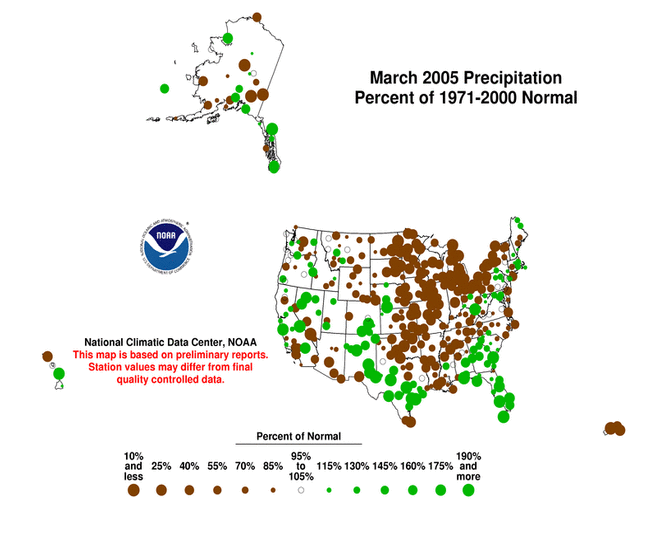
- March was wetter than normal across parts of the Pacific Northwest and northern Rockies, breaking a string of four very dry months.
- The month was drier than normal across a wide swath from the southern Plains to the Great Lakes.
- Unusually warmer than normal temperatures in the Northwest and northern Rockies combined with near to below-normal precipitation to cause short-term evapotranspirative stress in some areas.
- Long-term moisture deficits (last 24 to 36 to 60 months) persisted across much of the West into the northern High Plains and central Plains.
Please Note: The data presented in this drought report are preliminary. Ranks, anomalies, and percent areas may change as more complete data are received and processed.
National Overview
On the national scale,
- severe to extreme drought affected about 8 percent of the contiguous United States as of the end of March 2005, about the same as last month
- about 10 percent of the contiguous U.S. fell in the moderate to extreme drought categories (based on the Palmer Drought Index) at the end of March
- on a broad scale, the previous two decades (1980s and 1990s) were characterized by unusual wetness with short periods of extensive droughts, whereas the 1930s and 1950s were characterized by prolonged periods of extensive droughts with little wetness
- about 24 percent of the contiguous U.S. fell in the severely to extremely wet categories at the end of March
- a file containing the national monthly percent area severely dry and wet from 1900 to present is available
- historical temperature, precipitation, and Palmer drought data from 1895 to present for climate divisions, states, and regions in the contiguous U.S. are available at the Climate Division: Temperature-Precipitation-Drought Data page in files having names that start with "drd964x" and ending with "txt" (without the quotes).
Regional Overview
March was wetter than normal across parts of the Pacific Northwest and northern Rockies, breaking a string of four very dry months. The month was drier than normal across a wide swath from the southern Plains to the Great Lakes. Unusually warmer than normal temperatures in the Northwest and northern Rockies combined with near to below-normal precipitation to cause short-term evapotranspirative stress in some areas.
The March precipitation pattern at the primary stations in Alaska was mixed. The pattern was also mixed in Hawaii, but mostly wetter than normal in the central islands and drier than normal in the northern and southern islands. In Puerto Rico, most of the island had much below-normal rainfall during March, based on National Weather Service radar estimates of precipitation and on Cooperative station precipitation reports for the last 4 weeks. This marked the second consecutive month with acute moisture shortages across the island (February radar estimates, 8-week Cooperative station precipitation reports). March streamflow averaged near normal for Hawaii and Puerto Rico.
Long-term moisture deficits persisted in many areas. Three-month to six-month dryness was evident for parts of the Southeast. The Pacific Northwest experienced the fourth driest November-March on record this year, which is a continuation of dry conditions that started some six to seven years ago.
The southwestern U.S. has been very wet during the last seven months, with some states having record wet conditions—
but long-term deficits across parts of this area, most of the West, and much of the central to northern Plains, are reflected in the end of March U.S. Drought Monitor map. The Southwest has recovered at the 12 to 24 month timescales, but still shows dryness in some parts at the 36 to 60 month timescales.
Some regional highlights:
- Two states (MT, OR) had the tenth driest, or drier, January-March on record.
- Three states (MT, OR, SD) had the tenth driest, or drier, December-March on record.
- Five states (MT, OR, ND, SD, WA) had the tenth driest, or drier, November-March on record.
- Oregon also had the fifth driest October-March and ninth driest September-March.
- The National Weather Service reported that the San Juan International Airport had no measurable rainfall during the month, making March 2005 the driest month ever since records began in 1956. Reported impacts include numerous brush fires across southern Puerto Rico, lack of grass for cattle, and declining water levels in some reservoirs.
- End-of-month and monthly averaged soil moisture conditions were drier than normal across parts of the northern Rockies and northern High Plains, the central Plains, the Pacific Northwest, and the coastal Southeast, based on model computations (CPC-1, CPC-2, MRCC). The models also indicated dry soil moisture conditions in eastern Alaska and near the surface and at depth across parts of the central Plains to the Great Lakes.
- Streamflow levels were below seasonal norms across much of the Pacific Northwest and parts of the northern Rockies, northern and central Great Plains, and Southeast, both as computed by models and based on USGS observations.
- The weather pattern during March departed from the pattern of the last four months. Several storm systems broke through the western U.S. ridge near the end of the month to bring rain and snow to the moisture-starved Pacific Northwest. While not enough to make up for long-term deficits, the precipitation did bring short-term relief.
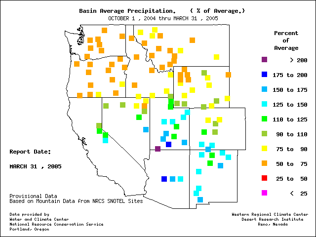
- The overall circulation pattern during this wet season has resulted in a sharp north-to-south contrast of the snow water content of the western mountain snowpack. Basin-averaged end-of-March snowpacks in parts of Arizona, Nevada, central California and Utah were above average, while snowpacks in Oregon, Washington, Idaho, Montana and the east slopes of the northern Rockies were significantly below average. This pattern is also apparent in basin-averaged water-year-to-date precipitation anomalies. As reported by the USDA, several individual stations in the remote high altitude SNOTEL network set new record lows (in the north) and highs (in the south) for both snow water content and water-year-to-date accumulated precipitation. Snowpack conditions in Alaska were generally above normal in the interior regions, below normal in coastal areas.
- Reservoir levels in the West reflected the abundance (Arizona) or lack (many other states) of precipitation, or preventative actions taken by water managers in anticipation of summer shortfalls (Washington). The percent area of the western U.S. (Rockies westward) experiencing moderate to extreme drought (as defined by the Palmer Drought Index) decreased from about 67% in July 2004 to under 10% by December. Intensification of drought in the Pacific Northwest (November, December, January, February, March) resulted in an expansion of the western drought area to about 26% by the end of February. Near- to above-normal precipitation from storms this month in the Pacific Northwest brought the western area coverage down to near 22% by the end of March.