North Atlantic
September marks a continuation of a record-long major hurricane (Category 3 or stronger) landfall drought in the United States. The last major hurricane to make landfall in the U.S. was Wilma on October 24, 2005. This major hurricane drought surpassed the length of the eight-years from 1861-1868 when no major hurricane struck the United States' coast. On average, a major hurricane makes landfall in the U.S. about once every three years. The reliable record of landfalling hurricanes in the U.S. dates back to 1851.
| Storm Type | September 2016 | September 1981-2010 Average | Record Most for September Period of Record: 1851-2016 |
|---|---|---|---|
| Tropical Storm (Winds > 39 mph) |
5 | 4.0 | 8 (2002, 2007, 2010) |
| Hurricane (Winds > 74 mph) |
2 | 2.6 |
5 (1955, 1969, 1981, 1998, 2000, 2005) |
| Major Hurricane (Winds > 111 mph) |
0 | 1.3 | 4 (1953, 1961) |
| Name | Dates of winds >39 mph |
Maximum Sustained Winds |
Minimum Central Pressure |
Landfall |
|---|---|---|---|---|
| Hurricane Hermine (Cat. 1) | August 28th–September 3rd | 80 mph | 982 mb | Landfall near Big Beng, Florida – September 2nd |
| Tropical Storm Ian | September 12th–16th | 60 mph | 994 mb | N/A |
| Tropical Storm Julia | September 12th–16th | 60 mph | 994 mb | N/A — formed over land in northern Florida |
| Tropical Storm Karl | September 14th–25th | 70 mph | 988 mb | N/A |
| Tropical Storm Lisa | September 19th–25th | 50 mph | 999 mb | N/A |
Significant Events
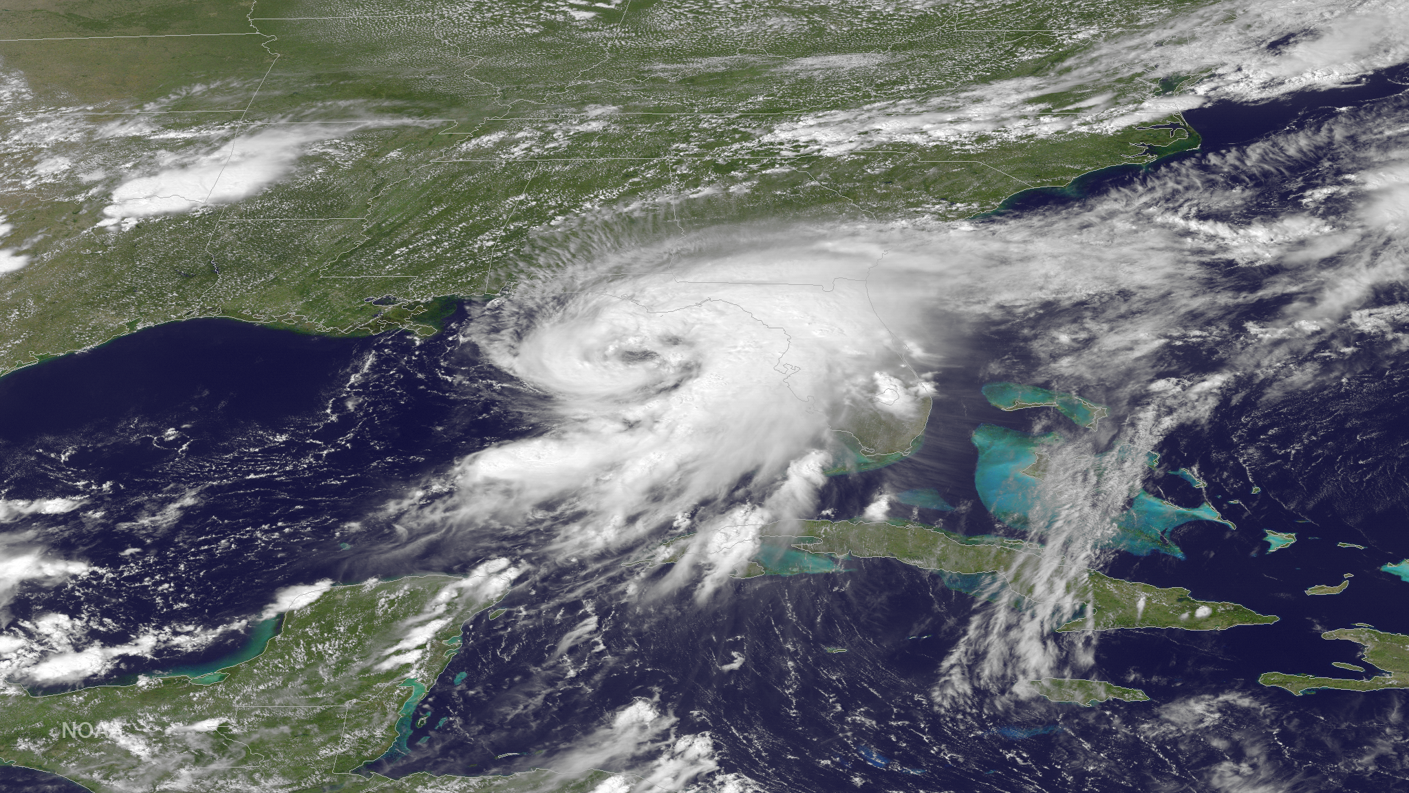
Hurricane Hermine formed from a tropical wave that had traversed the Atlantic Ocean from Cape Verde. Hermine moved across the Leeward Islands and parts of the Greater Antilles as a tropical wave dropping three to five inches of rain across parts of Guadeloupe and Cuba. Hermine reached tropical depression strength on August 28th off the west coast of Cuba in the Gulf of Mexico and became a tropical storm on the 30th when winds near the center of the storm reached 40 mph. As the storm moved off to the northeast it reached hurricane strength on September 2nd before making landfall in the Big Bend area of Florida with maximum sustained winds of 80 mph. Hermine brought a storm surge of 7.5 feet to the Florida coast causing coastal flooding in a sparsely populated area. Hermine quickly weakened as it moved over land and across the Southeast. Hermine dropped torrential rainfall from Florida and along coastal areas of Georgia and the Carolinas with widespread flooding. The torrential rainfall provided some drought relief along its path. Areas in Florida received over 18 inches of rain with over 13 inches reported in North Carolina. As Hermine moved off the North Carolina Coast it re-strengthened as a post-tropical tropical storm with winds of 70 mph causing a storm surge of over 4 feet along the Outer Banks, the highest water levels observed there since Hurricane Sandy in 2012. Hermine meandered to the northeast where it remained off the Mid-Atlantic coast for over a week causing coastal flooding from Massachusetts to Virginia. Some outer rain bands did impact coastal areas, but the storm remained off shore and eventually moved out to sea. At least five fatalities were blamed on the impacts from Hermine.
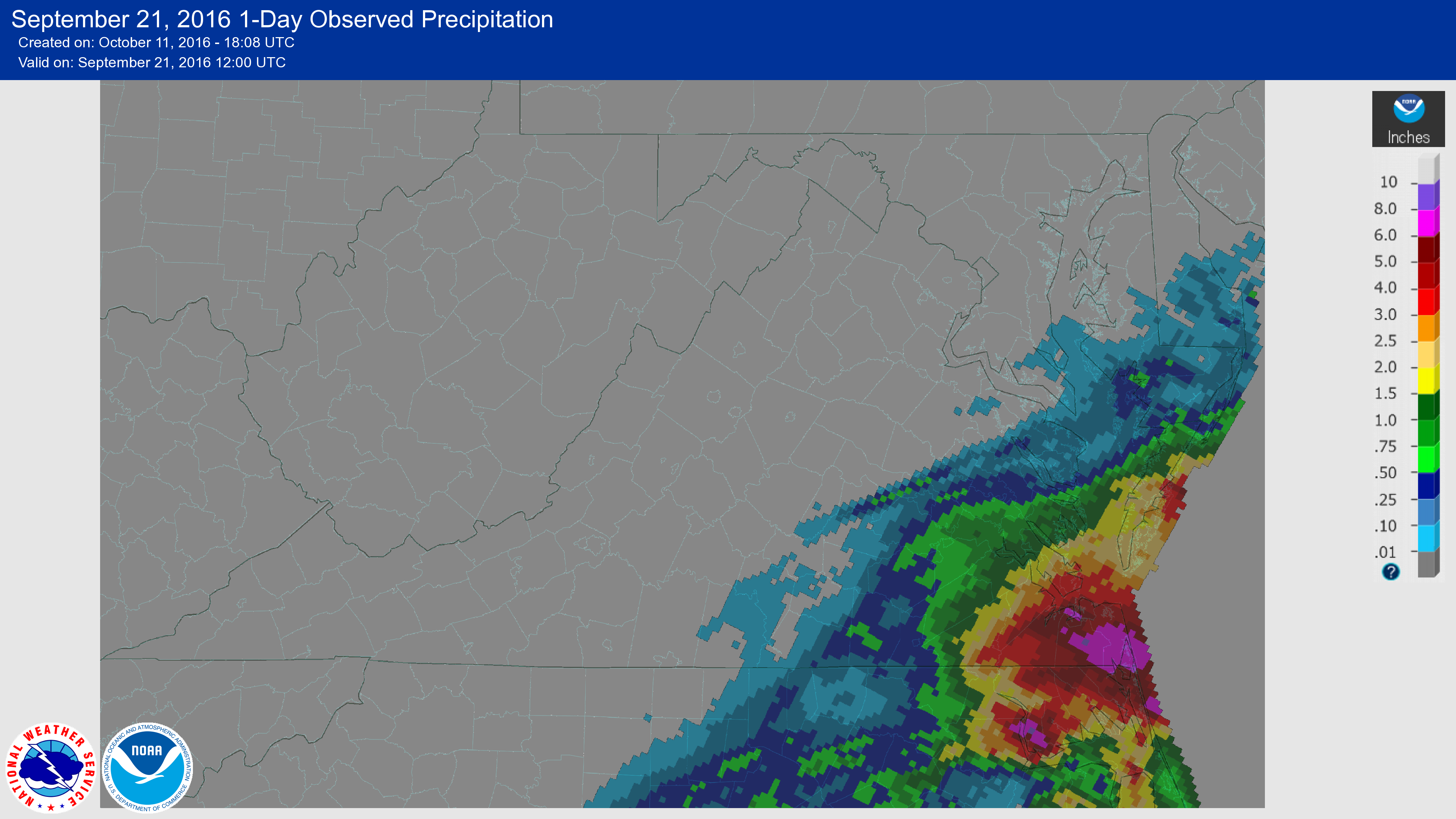
The precursor tropical wave that would become tropical storm Julia moved through the Bahamas and became a tropical depression on September 12th off the east coast of Florida. The depression moved over northern Florida and strengthened to a tropical storm over land on the 14th, the first such occurrence in Florida. However, Julia quickly weakened and moved off shore where it drifted off the Carolina's coast for several days. The remnants of Julia moved northward dropping heavy rain over northeastern North Carolina and southeastern Virginia where widespread flooding was observed. Over a foot of rain fell in parts of North Carolina with over 18 inches of rain near Hampton Roads, Virginia. More than 100 people had to be rescued from the flood waters and over one million gallons of sewer spilled into the Pasquotank River due to the heavy rains. A state of emergency was declared in 11 counties in North Carolina. No fatalities were reported during the event.
East Pacific
| Storm Type | September 2016 | September 1981-2010 Average | Record Most for September Period of Record: 1949-2016 |
|---|---|---|---|
| Tropical Storm (Winds >39 mph) |
7 | 3.6 | 7 (2016) |
| Hurricane (Winds >74 mph) |
6 | 2.2 |
6 (1992 and 2016) |
| Major Hurricane (Winds >111 mph) |
2 | 1.1 | 4 (1972, 1993) |
| Name | Dates of winds >39 mph |
Maximum Sustained Winds |
Minimum Central Pressure |
Landfall |
|---|---|---|---|---|
| Hurricane Lester (Cat. 4) | August 24st– September 7th | 140 mph | 947 mb | N/A — storm brushed northern Hawaii |
| Hurricane Madeline (Cat. 4) | August 26th– September 3rd | 130 mph | 950 mb | N/A — storm brushed southern Hawaii |
| Hurricane Newton (Cat. 1) | Sep 4th– 7rd | 90 mph | 979 mb | Near Cabo San Lucas, Mexico |
| Hurricane Orlene (Cat. 2) | September 11th–17th | 110 mph | 967 mb | N/A |
| Hurricane Paine (Cat. 1) | September 18th–21st | 90 mph | 977 mb | N/A — remnants brought heavy rain to western U.S. |
| Tropical Storm Roslyn | September 25th–29th | 50 mph | 1000 mb | N/A |
| Hurricane Ulika | September 26th–30th | 75 mph | 992 mb | N/A |