Note: This report catalogs recent tropical cyclones across the North Atlantic and East Pacific and places each basin’s tropical cyclone activity in a climate-scale context. It is not updated in real time. Users seeking the real time status and forecasts of tropical cyclones should visit The National Hurricane Center.
| Climate of 2002 Atlantic Hurricane Season National Climatic Data Center, Last updated - 16 December 2002 |
 June
June
 larger image |
Hurricane season in the Atlantic begins on June 1st. The map to the left shows sea-surface temperatures for the Atlantic averaged over the period 16th-22nd of June. In order for tropical waves to develop into tropical storms and hurricanes, sea surface temperatures generally need to be above 26°C (78.8°F). As is evident in the map, the Gulf of Mexico and Caribbean Sea region as well as much of the western tropical Atlantic have warm enough SSTs for hurricane formation to occur. However, other atmospheric conditions have not been favorable for tropical storm development, consequently in June 2002 there was no tropical storm or hurricane activity.
|
| On average only one named system (tropical storm strength or greater) forms in June in the Atlantic basin, so the lack of activity in June is not unusual. In 2001, however, Tropical Storm Allison formed in the Gulf of Mexico on June 5 and became the costliest tropical storm in U.S. history causing around $5 billion in damage. This was principally due to the intense rainfall accompanying the slow-moving storm. Rainfall totals for June 4-10, 2001 for coastal Texas and Louisiana can be seen on the map to the right. | 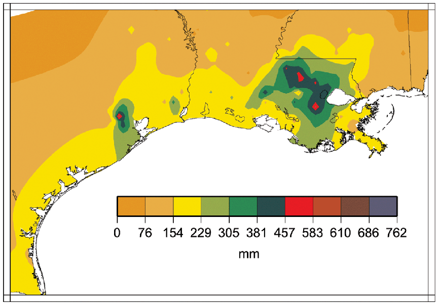 larger image |
July
 larger image |
The map to the left shows sea-surface temperatures for the Atlantic averaged over the week of July 28th-August 3rd. Although much of the Gulf of Mexico and the Caribbean have sufficiently warm waters to support tropical storm development, much of the tropical Atlantic is at or below average for this time of year. As a consequence of this and a developing El Nino, scientists at NOAA's Climate Prediction Center have revised the seasonal prediction of Atlantic tropical storm activity. They are predicting that there will be 7-10 tropical storms this year (compared to 9-13 in the original outlook) of which 4-6 could develop into hurricanes and 1-3 of these hurricanes could be 'major' (category 3 or higher on the Saffir-Simpson Scale).
|
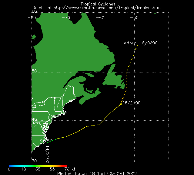
| On average, 2 tropical storms will have formed in the Atlantic Basin by the end of July. July 2002 saw the development of Tropical Storm Arthur (shown in the satellite image to the right) which began as a tropical depression off the coast of North Carolina on July 14th and tracked northeastward becoming a tropical storm by the 16th with maximum sustained winds of 60 mph. Arthur never threatened land and there was no associated damage or death. |  larger image |
August
 larger image |
The map to the left shows sea-surface temperatures for the Atlantic averaged over the week of August 18th-August 24th. Much of the Gulf of Mexico and Caribbean waters now have above average sea surface temperatures for this time of year though as of the end of August, no hurricane had formed in the Atlantic (compared to an average of 2 by September 1st). Three tropical storms formed (Bertha, Cristobal and Dolly) bringing the seasonal total to four. On average, around 5 named storms will have formed in the Atlantic Basin by the end of August.
|
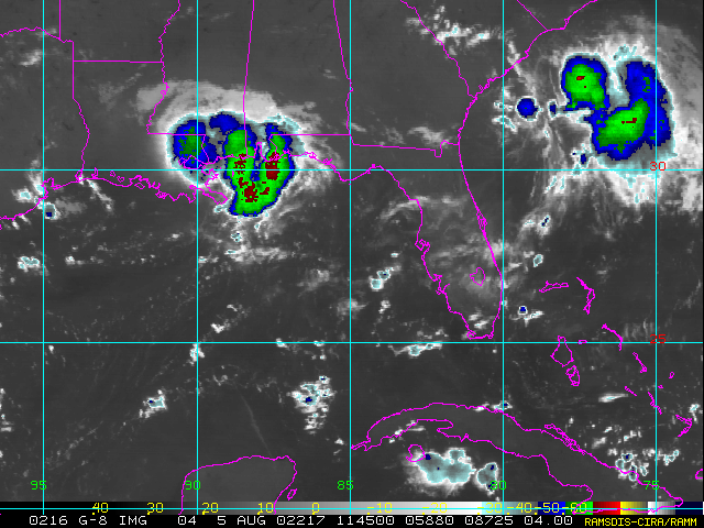
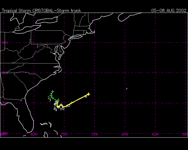
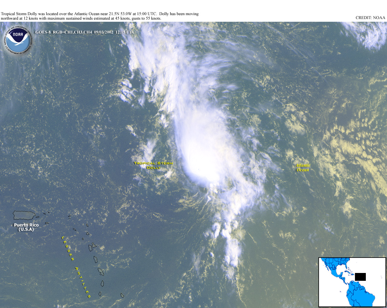
| August 4th saw the development of Tropical Storm Bertha (shown in the satellite image to the right). Bertha began as a tropical depression in the northern Gulf of Mexico just east of the mouth of the Mississippi and tracked northwestward across Louisiana before turning to the southwest. Bertha then reemerged over Gulf waters where it was able to regain some strength before coming ashore in Texas on the 9th and rapidly dissipating. Tropical Storm Cristobal developed on the 7th resulting from a tropical depression which formed on the 5th about 175 miles of the coast of South Carolina. It then moved slowly to the south and east and then as a tropical storm it moved off the East and eventually to the northeast. Cristobal never threatened land and its maximum windspeed was 50 mph on the 8th. Tropical Storm Dolly formed in the far eastern Atlantic and though maximum windspeeds of 60-65 mph were reached on August 30th, as of September 1st, windspeed was only around 40 mph and Dolly was poorly organized and still 750 miles east of the Lesser Antilles. |
 larger image |
September
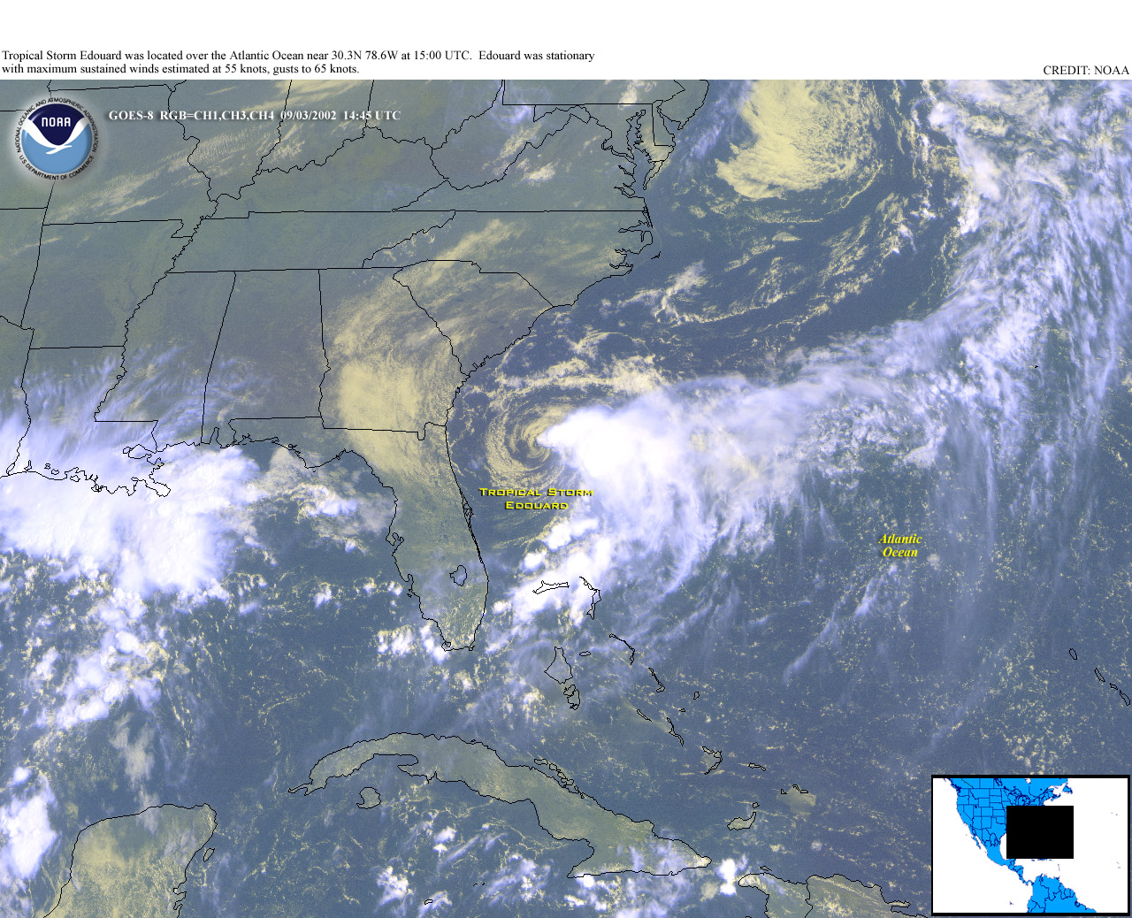
| September 2002 was the most active month of any year on record with the formation of eight named storms. Four of these storms became hurricanes and in addition, there was one tropical depression which did not reach tropical storm strength. Tropical Storm Dolly, which formed in August also persisted into September. |
| The first hurricane of the 2002 season developed in early September. Hurricane Gustav, shown in the satellite image to the right, was a subtropical storm on September 8th and touched Cape Hatteras, NC on the 10th before turning to the northeast and becoming a category 1 hurricane on the 11th. Maximum sustained winds reached 80 knots (~90 mph), and minimum central pressure was 960mb. This is the latest date that the first hurricane of the season has formed in the Atlantic since 1941. |  larger image |
 larger image |
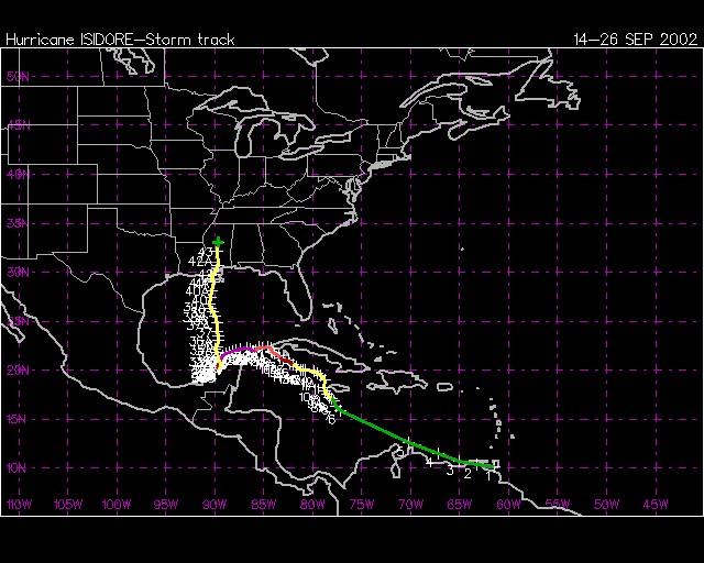
Hurricane Isidore was the second hurricane of the season and strengthened to hurricane force on September 19th, quickly intensifying to a category 2 hurricane by the 20th. Maximum sustained winds of 110 kts (127 mph) (a category 3 hurricane) were reached late on Saturday 21st and persisted throughout Sunday 22nd. After pounding western Cuba and causing heavy flooding there, Isidore skirted the Yucatan shore on Sunday and then abrubtly swung inland over the peninsula causing at least 2 deaths and extensive damage and power loss across northern Yucatan. As much as 12-20 inches of rain fell over the northern coastline. Isidore weakened as it remained over the Yucatan Peninsula and then moved northward across the Gulf of Mexico to make landfall on the Louisiana coast, just west of Grand Isle as a 70pmh tropical storm on the 26th. Isidore caused torrential rain to fall across a wide area of the U.S., producing totals of over 6-12 inches from Louisiana to Tennessee and Kentucky. |
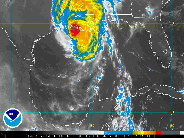
| The most intense hurricane of the 2002 season so far developed in late September, though did not reach peak instensity until early October. Hurricane Lili, shown in the satellite image to the right, began as a tropical depression on September 13th approximately 1,000 miles west of the Lesser Antilles. By the 23rd, Lili had moved across the Windward Islands as a tropical storm. As it moved across the Caribbean, Lili fluctated in intensity and was a category 1 hurricane near western Cuba on October 1st. Continued below in October section. | 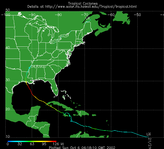 larger image |
|
Other tropical storms in September included: |
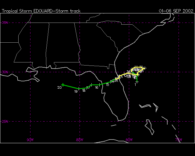
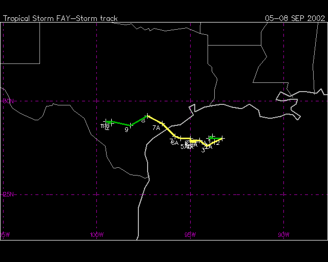
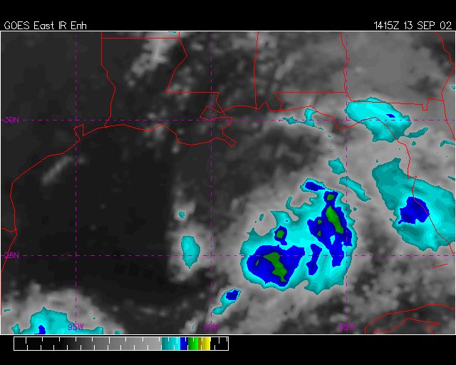
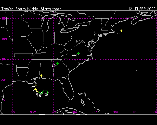
October
|
LILI: Continued from September. Hurricane Lili came ashore on Thursday 3rd October in southwest Louisiana (on the west side of Vermillion Bay) as a category 2 hurricane. After reaching windspeeds of 145mph (category 4) on the 2nd and maintaining intensity into the 3rd, it suddenly lost intensity and was a much weaker hurricane by landfall. Still a powerful storm, it led to widespread damage, flooding and power outages. At least 13 deaths have been attributed to Lili, most of them occurring as it crossed the Caribbean. Four people died in Haiti as Lili's outer rain-bands caused torrential rain and mudslides, while seven victims were reported in Jamaica and one death each in Cuba and the United States have been blamed on the storm. Damage costs for Louisiana alone have been estimated at approximately $170 million (AP). |
 larger image |
 larger image |
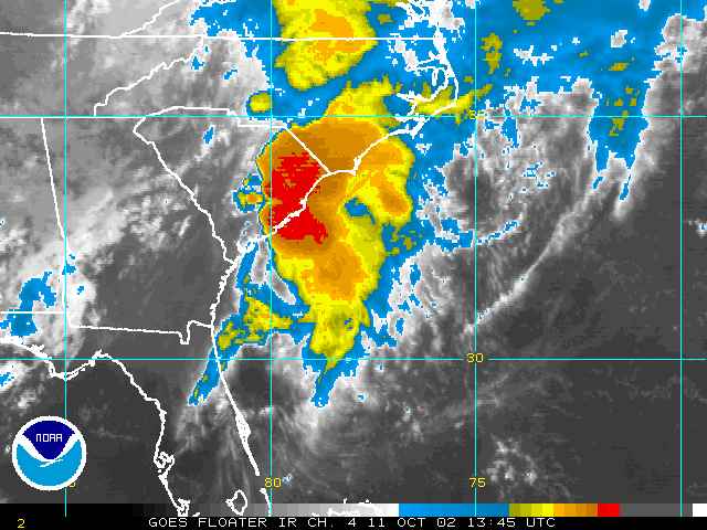
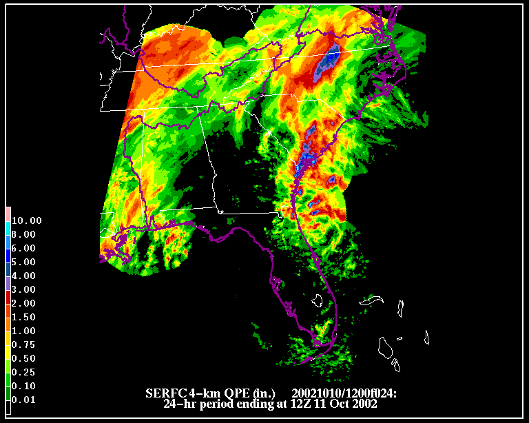
Tropical Storm Kyle (picured to the left on September 26th, while at hurricane strength) made landfall as a minimal tropical storm along the coast of South Carolina on October 11th. Ahead of the storm, heavy rain occurred, with Edisto Beach State Park in South Carolina reporting 6.35 inches having fallen in the 24 hours of October 10th-11th. Minor flooding was reported and tides were 1-2 feet higher than normal along much of the southern South Carolina and northern Georgia coasts.
|
Though Lili and Kyle continued into October, no tropical storms actually formed in October 2002 in the Atlantic Basin, which is quite unusual. Only one tropical cyclone formed in the month - Tropical Depression Fourteen which developed on the 14th and though it brought some rain to Cuba, Jamaica and the Cayman Islands, no reports of damage or casualties resulted, and the storm merged with a cold front on the 16th.
Seasonal Summary
The Atlantic Hurricane Season begins on June 1st and ends on November 30th. There were 12 named storms, compared to a 1944-96 annual average of 9.8. Four of those named storms became hurricanes of which 2 were classified as major (category 3-5 on the Saffir-Simpson Scale). This compares to an average of 5.8 hurricanes a year, 2.5 of which are major based on a 53-year average. And there were 2 additional tropical depressions. So, there were more named tropical cyclones than the long-term mean, but fewer strong storms. This translates to a slightly below average season overall, according to NOAA's Climate Prediction Center, since the tropical storms were less intense. The season was also slow to begin, extremely active in September and less active than average at its end. Eight named systems developed in September as well as a tropical depression, making it the month with most tropical storm formations of any month on record for the Atlantic basin. 
Seven tropical storms made landfall on the continental U.S. in 2002 - the most since 1998, when seven was also the number of landfalling tropical systems for the U.S. Hurricane Lili was the first hurricane to impact the coast of the U.S. since Irene in October 1999.
Notable tropical systems in 2002 include Hurricane Isidore and Lili in September for their intensity, and Hurricane Kyle, also in September, for its duration. Kyle was the third longest lived tropical cyclone in the Atlantic basin after Ginger of 1971 and Inga of 1969. Kyle formed on September 20th and spent over 3 weeks in the North Atlantic before finally coming ashore in South Carolina on October 11th. Isidore became a category 3 hurricane as it moved into the southeastern Gulf of Mexico and hit the Yucatan Peninsula on September 22nd at category 3 strength. After weakening over the Yucatan Peninsula, it never quite regained hurricane strength and came ashore in Louisiana as a tropical storm. Lili was the only hurricane to make landfall in the United States in 2002, and did so at category 2. Lili had been a category 4 hurricane shortly before landfall and quickly weakened before reaching the west Louisiana coastline on October 3rd. NOAA's paleo-hurricane page contains information and links for an historical perspective on Atlantic hurricanes and landfalling storms on U.S. coastlines.
Useful Links