Note: This Synoptic Discussion describes recent weather events and climate anomalies in relation to the phenomena that cause the weather. These phenomena include the jet stream, fronts and low pressure systems that bring precipitation, high pressure systems that bring dry weather, and the mechanisms which control these features — such as El Niño, La Niña, and other oceanic and atmospheric drivers (PNA, NAO, AO, and others). The report may contain more technical language than other components of the State of the Climate series.
Synoptic Discussion
The  weather pattern over the contiguous United States during August 2011 was a continuation of the pattern which has dominated the country for much of the summer. A large and persistent upper-level high pressure ridge brought hot and mostly dry weather to the Southern Plains, worsening drought conditions. Waves of low pressure in the upper-level westerly flow dragged cool fronts across the northern tier states. These fronts brought areas of rain, mostly to the Central and Northern Plains, and near-normal monthly temperatures to some ares. A few of the fronts penetrated into the Southeast beneath the upper-level high pressure ridge, but weakened considerably and had minimal impact. By the end of the month, Hurricane Irene moved up the East Coast along a cold front, bringing flooding rains to parts of the Mid-Atlantic coast and much of the Northeast, with August 2011 ranking as the wettest August in the 1895-present record for New Jersey, New York, Vermont, and New Hampshire.
More than 4800 daily high temperature records were tied or broken in August 2011, and there were 301 reports of the record hottest temperature for August and 100 reports of all-time record hottest temperature ever. Nighttime temperatures were also warm, with nearly 5500 reports of record daily warm minimum temperatures.
Six states in the Southwest and Southern Plains (Arizona, Colorado, New Mexico, Texas, Oklahoma, and Louisiana) had the hottest August in the 1895-2011 record while five others, in the central Rockies and Southeast, ranked in the top ten warmest category. The persistence of this circulation pattern for the last three months resulted in the hottest summer on record for New Mexico, Texas, Oklahoma, and Louisiana, and second hottest summer for Delaware, Georgia, and the Carolinas, with 12 other states ranking in the top ten warmest category. In contrast, Washington and Oregon, which were beneath an upper-level trough for much of the summer, had the 18th and 19th, respectively, coolest summer on record. The summer 2011 Residential Energy Demand Temperature Index (REDTI) was the highest summer REDTI value in the 117-year record, indicating that the national residential energy consumption was about 22 percent higher than the average energy consumption.
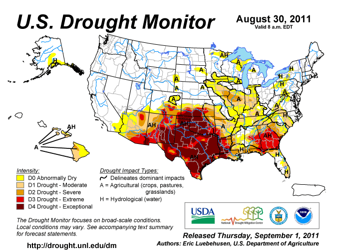
The circulation pattern inhibited the formation of severe storms and resulted in widespread dryness across much of the West, Southern Plains, Southeast, and Midwest, with eight states having the tenth driest, or drier, August in 2011. In spite of the hot and dry weather, wildfire activity during most of August was below average. June-August 2011 was the driest summer on record for Texas and tenth driest, or drier, for four other states (New Mexico, Oklahoma, Georgia, and South Carolina). These same regions have been plagued by dry weather for much of the year and even the last 12 months, with New Mexico, Texas, and Louisiana having the driest year-to-date and (along with Georgia) the driest September-August. There was little relief to the drought in the Southern Plains, where more than half (54 percent) of the South region was classified as experiencing exceptional (D4) drought according to the U.S. Drought Monitor (USDM), and two-thirds was in extreme to exceptional (D3-D4) drought. Almost all (95 percent) of Texas was experiencing extreme to exceptional (D3-D4) drought at the end of August, a record for the 11-year USDM history. Several climate divisions in New Mexico, Oklahoma, Texas, and Louisiana had a Palmer Hydrological Drought Index (PHDI) for August 2011 that was record dry based on the 111-year PHDI record. The summer 2011 drought in Texas has been so severe that it is matched by only one summer in a 429-year analysis based on tree-ring records. Nationally, the size of the drought footprint (moderate to exceptional drought as measured by the USDM) held steady during the month at about 33 percent.
When averaged together, the mixture of temperature and precipitation extremes gave the U.S. the second warmest and 27th driest August in the 117-year record. Averaging extremes tends to cancel them out. But when extremes are combined cumulatively, like in the U.S. Climate Extremes Index (CEI), they tell a different story. The large total area of hot daytime temperatures, warm nighttime temperatures, and very wet or very dry conditions gave the U.S. the third highest summer CEI and fifth highest August CEI in the 1910-2011 record. On a regional basis, the CEI was record high for the Southeast region (summer), South region (August and summer), and Southwest region (August).
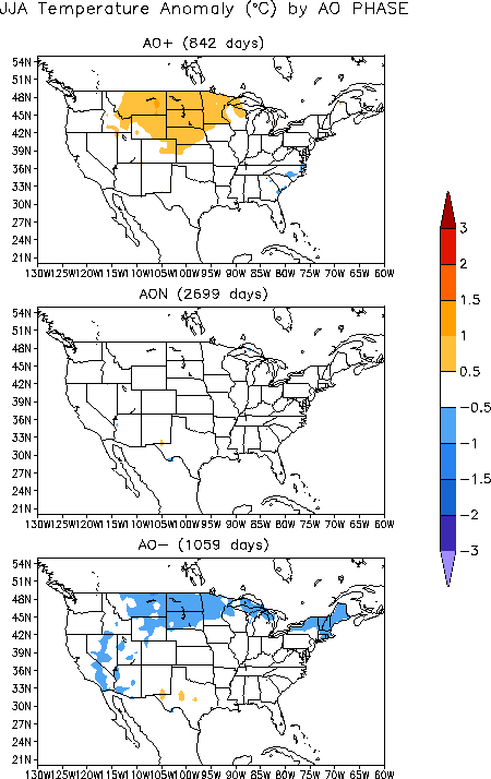
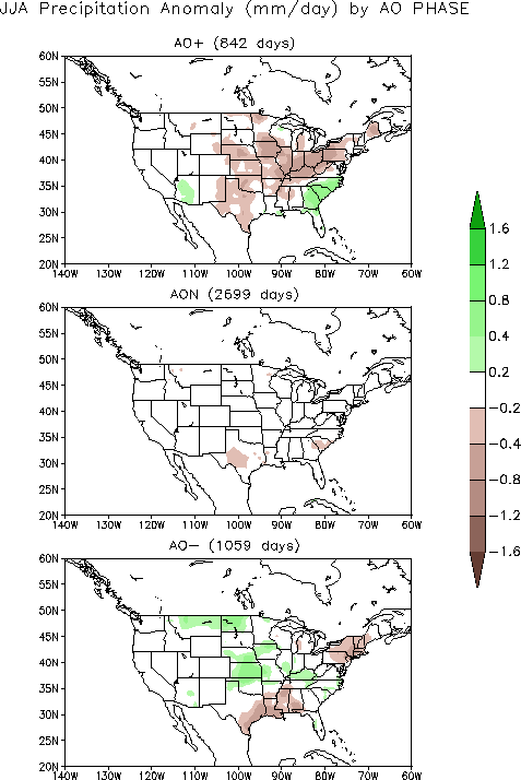
Cold fronts and low pressure systems moving in the storm track flow are influenced by the broadscale atmospheric circulation. Four such large-scale atmospheric circulation drivers were potentially influential during August. Ocean temperatures and atmospheric circulation anomalies indicated that the equatorial Pacific had transitioned back into a weak La Niña state. La Niña this time of year (June-August) is weakly associated with temperature and precipitation anomalies across the U.S. — temperatures are typically warmer than normal in the central U.S. and cooler than normal in the West, with drier than normal conditions dominating across the central and eastern two-thirds of the country. The Pacific/North American (PNA) pattern was positive for most of the month. The PNA this time of year (summer, represented by July on the PNA teleconnection maps) typically has a weak relationship with temperature throughout the Lower 48 States, but a positive PNA is weakly associated with wet conditions in the central regions. The North Atlantic Oscillation (NAO) pattern was negative in early August then neutral for the rest of the month. A negative NAO this time of year (summer, represented by July on the NAO teleconnection maps) is typically associated with warmer-than-normal temperatures and drier-than-normal conditions in the Southern Plains and Southeast, cooler-than-normal weather in the Northwest and Northern Plains, and wetter-than-normal conditions in the Northern Plains and Midwest. The Arctic Oscillation (AO) pattern was slightly negative for most of the month. A negative AO this time of year (June-August) is typically associated with coolness in the Northern Plains and New England, dryness in the South and Northeast, and anomalous wetness in the Northern to Central Plains.
The pattern of observed temperature anomalies for August 2011 and the last three months (June-August) is a reasonable match for the AO and NAO pattern for August (summer). The August 2011 and June-August 2011 precipitation patterns are a reasonable match for the PNA, NAO, and AO patterns in the Northern and Central Plains (wet) and (with La Niña) Southern Plains (dry).