Monthly Report Summary Information
The Monthly Report Summary Information is a synopsis of the collection of national and global summaries released each month.
National Summary Information - May 2014
See Full Report
Spring temperatures and precipitation near average for the contiguous US
The West continued to be warmer than average during spring, while parts of the East were cooler than average; many states face intensifying drought
The average temperature for the contiguous U.S. during spring was 51.1°F, 0.2°F above the 20th century average, ranking near the middle among all springs in the 120-year period of record. For May, the contiguous U.S. temperature was 61.2°F, 1.0°F above the 20th century average, tying as the 32nd warmest May on record. Both the East and West coasts were warmer than average during May, while much of the central U.S. had near-average temperatures.
The spring national precipitation total was 8.01 inches, which was slightly above the 20th century average. Dryness in the central U.S. was balanced by wetter than average conditions in the Northwest, Midwest, and along the East Coast. The May national precipitation total of 2.76 inches was 0.15 inch below average, with drought conditions intensifying in parts of the Central and Southern Plains. Drought continued its stranglehold in the West.
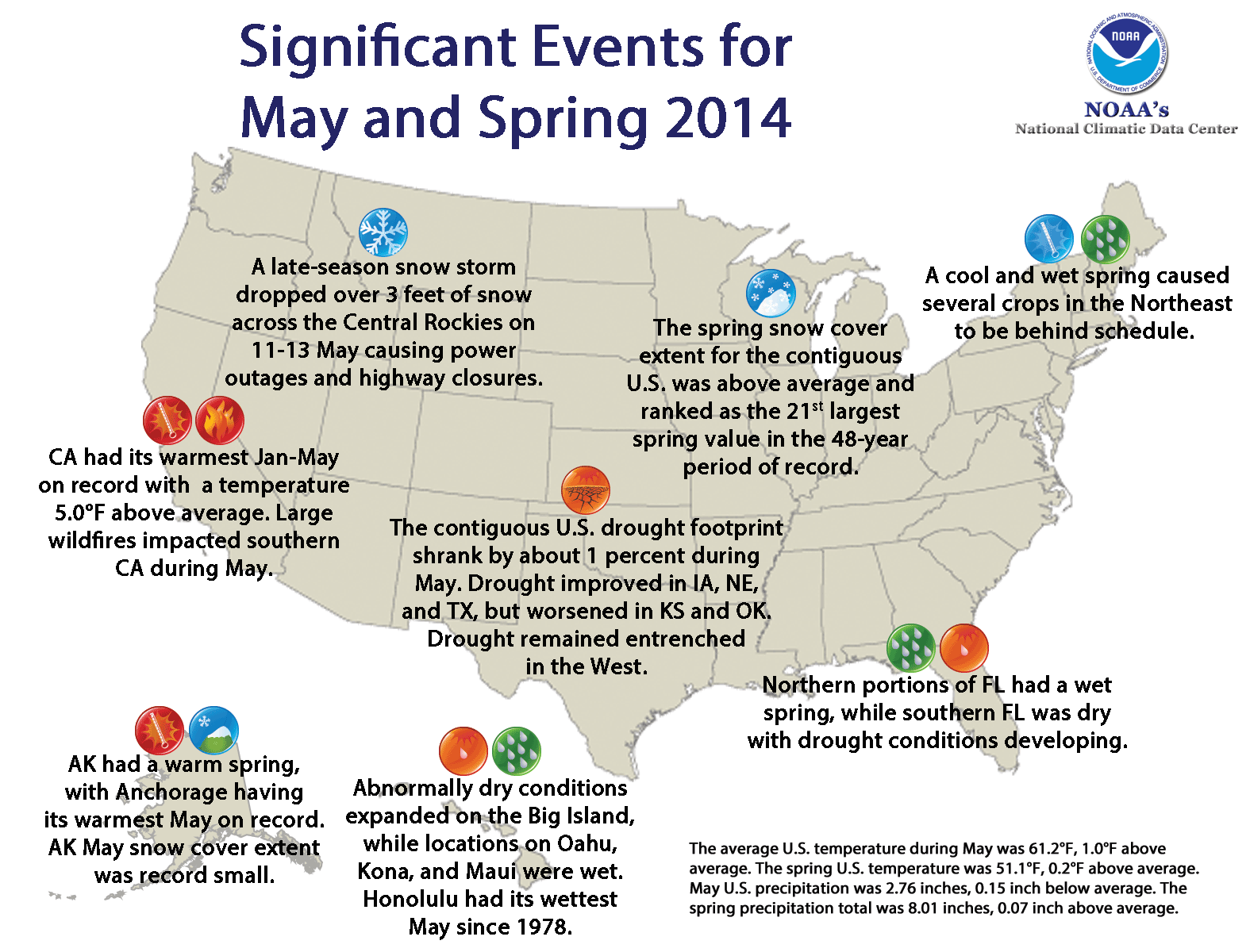
Significant climate events for May/spring 2014.
Click image to enlarge, or click here for the National Overview.
Note: The May Monthly Climate Report for the United States has several pages of supplemental information and data regarding some of the exceptional events from the month, season, and year-to-date.
Major climate events NOAA is closely monitoring:
- Persisting and intensifying drought in parts of the West and the Central and Southern Plains: Long- and short-term dryness will continue to increase wildfire risk and impact water resources and agriculture. More information is available from the U.S. Drought Monitor.
- Probability of El Niño increases later this year: According to NOAA's Climate Prediction Center, there is a 70 percent chance of El Niño conditions developing this summer, increasing to an 80 percent chance by autumn and winter. El Niño conditions could have significant impacts on temperature and precipitation patterns across the United States. More information is available from the Climate Prediction Center.
- The North Atlantic hurricane season began on June 1: According to NOAA's Climate Prediction Center, the 2014 North Atlantic hurricane season is forecasted to be near-normal or below-normal in terms of the number of tropical storms, hurricanes, and major hurricanes. The last North Atlantic hurricane season with a below-average number of named storms was in 2009. More information is available from the Climate Prediction Center and NOAA's National Hurricane Center.
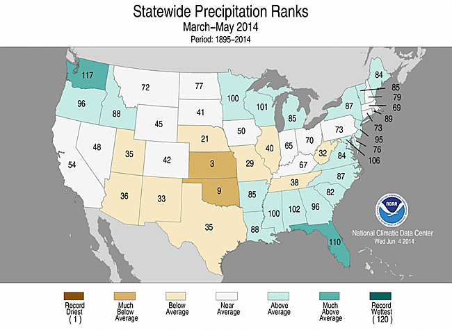
U.S. climate highlights: spring (March–May) 2014
- California statewide average temperature tied with 2013 as the fifth warmest spring on record with a seasonal temperature 4.1°F above the 20th century average. Each season since the winter of 2012/13 has been warmer than average in California.
- Wisconsin both had their 11th coldest spring on record, with temperatures 2.1°F and 3.2°F below average, respectively.
- Oklahoma had its ninth driest spring and driest since 2005, with 6.42 inches of precipitation, 4.31 inches below average.
- Washington state had its fourth wettest spring with 13.88 inches of precipitation, 4.65 inches above the 20th century average.
- Alaska had its eighth warmest spring on record, with a seasonal temperature 3.1°F above the 1971-2000 average. The spring heat in Alaska peaked in May, which was the state's sixth warmest in the 1918-2014 record. Many locations across the state, including Anchorage, King Salmon, and Kodiak, had their warmest May on record. Alaska also had its 25th driest spring on record, with a precipitation total 14.7 percent below the 1971-2000 average. The combination of a warm and dry spring contributed to the state having its smallest May snow cover extent in the 48-year period of record.
- The U.S. Climate Extremes Index (USCEI) for spring was near average. On the national-scale, the spatial extent of one-day precipitation extremes ranked as the third highest spring value on record at 60 percent above average. On the regional scale, the elements that track the spatial extent of cold daily highs and lows were elevated across the central U.S., one-day precipitation extremes were record and near-record high in the East, while the spatial extent of drought was record high in the West. The USCEI is an index that tracks extremes (falling in the upper or lower 10 percent of the record) in temperature, precipitation and drought across the contiguous U.S.

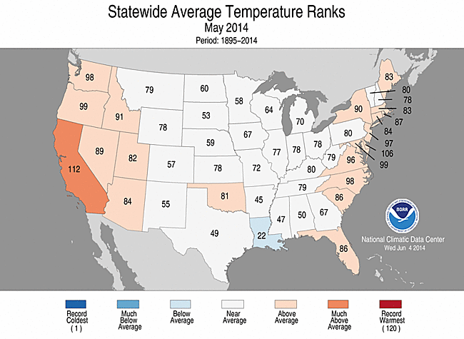
May 2014 Statewide Temperature (top)
and Precipitation (bottom) ranks
U.S. climate highlights: May 2014
- A large portion of the California tied its ninth warmest May on record, with a statewide temperature 3.9°F above average. This marked the seventh consecutive month with above-average temperatures for California. No other state had May temperatures that ranked among the 10 warmest or coldest on record.
- Below-average and above-average precipitation totals were Kansas had its sixth driest May on record, with 2.02 inches of precipitation, 1.83 inches below average.
- According to the June 3 U.S. Drought Monitor report, 37.3 percent of the contiguous U.S. was in drought, down about 1.1 percent compared to the end of April. Both improvement and degradation of drought conditions occurred on the regional scale. Beneficial rain improved drought conditions across parts of Texas, Nebraska, and Iowa. In Texas, despite the short-term precipitation relief, extreme and exceptional drought coverage in the state is five times greater than at the start of the calendar year. Drought conditions worsened in parts of Kansas and Oklahoma. The long- and short-term dry conditions across the Southern Plains and the West helped fuel several large wildfires that threatened homes during May.
- May precipitation totals were mixed across Hawaii. Locations on the Big Island were drier than average, which caused an expansion of abnormally dry conditions, according to the U.S. Drought Monitor. Locations on Oahu, Kona, and Maui had their wettest May on record, while the Honolulu airport had its wettest May since 1978.

May 2014 Statewide Temperature (top)
and Precipitation (bottom) ranks
U.S. climate highlights: year-to-date (January–May) 2014
- The year-to-date average temperature for the contiguous U.S. was 43.2°F, 0.1°F below the 20th century average, ranking near the middle value in the 120-year period of record. This was the coldest first five months of any year since 1996.
- During the first five months of 2014, California's January-May temperature of 55.2°F was 5.0°F above the 20th century average, marking the warmest such period for the state. This bested the previous record, set in 1934, by 0.1°F.
- During the January-May period, Florida had its eighth wettest start to the year.
- The USCEI for the year-to-date was the 14th highest value on record, at 145 percent of average. Elements that contributed to the above-average USCEI included: the spatial extent of cold maximum and minimum temperatures, warm maximum temperatures, one-day precipitation totals and the spatial extent of drought.

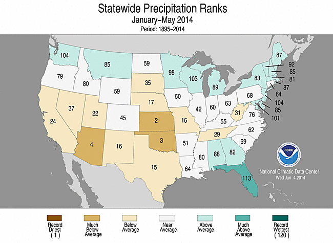 January–May 2014 Statewide Temperature (top)
 and Precipitation (bottom) ranks