Monthly Report Summary Information
The Monthly Report Summary Information is a synopsis of the collection of national and global summaries released each month.
National Summary Information - February 2014
See Full Report
U.S. saw regional extremes for winter 2013/2014 including widespread dryness, unusual cold, record warmth, and heavy snow
Overall, contiguous U.S. experienced much drier and colder than average winter that ranked ninth driest and 34th coldest on record.
The average temperature for the contiguous U.S. during the winter season (December 2013-February 2014) was 31.3°F, 1.0°F below the 20th century average, and the coldest winter since 2009/10. This winter was in sharp contrast to the previous two winters, and most winters of the past two decades, when temperatures were predominately warmer than the 20th century average. The February temperature was 32.2°F, 1.6°F below average, and the 37th coldest February on record.*
Despite regional heavy snow, overall total winter precipitation averaged across the contiguous U.S. was much below average. With a total of 5.69 inches, 1.10 inches below average, this was the driest winter since 2001/02. The February national precipitation total was 2.12 inches, ranking near the middle of the 120-year period of record.
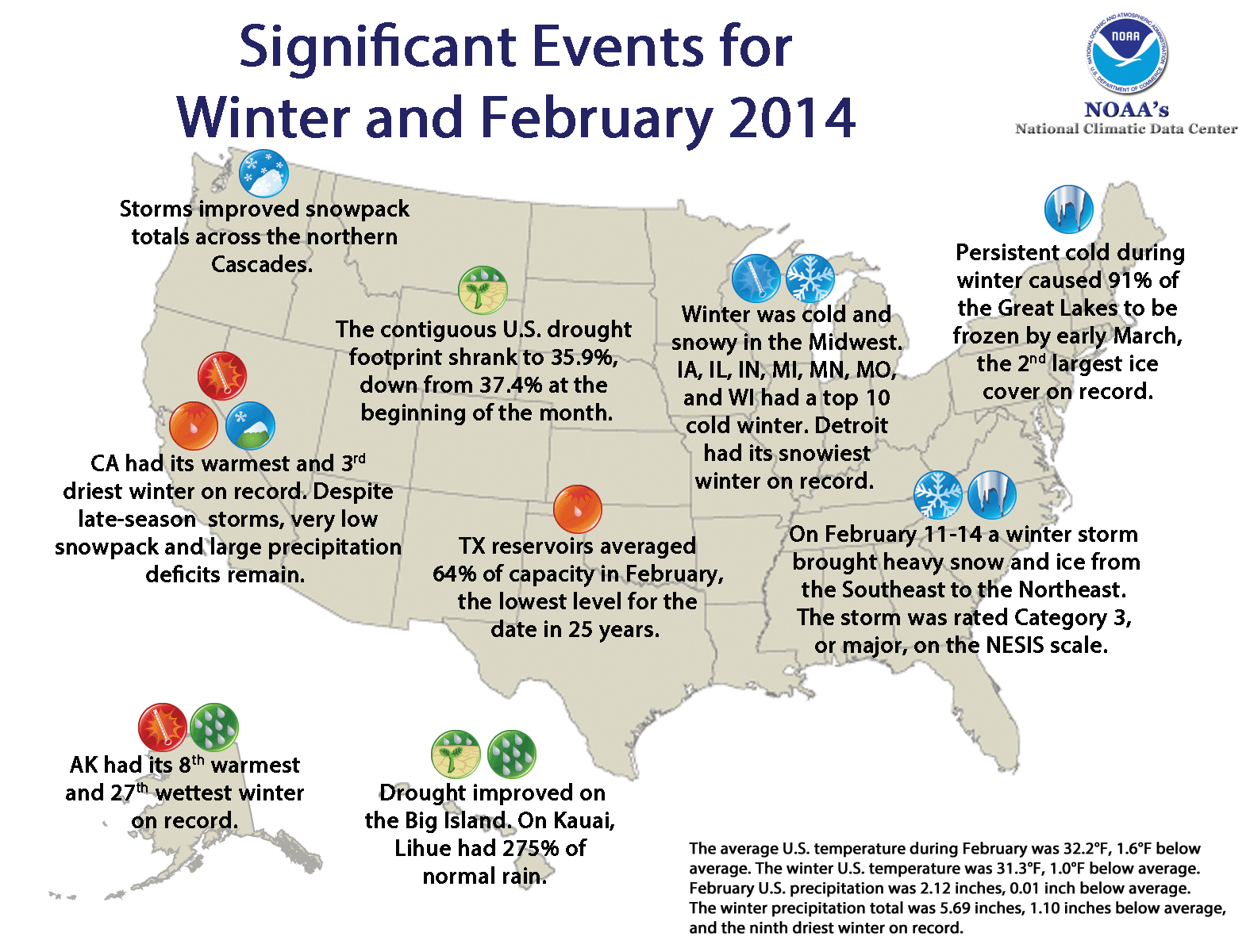
Significant climate events for winter 2013/14 and February 2014. Click image to enlarge, or click here for the National Overview.
Note: The February Monthly Climate Report for the United States has several pages of supplemental information and data regarding some of the exceptional events from the month and season.
U.S. climate highlights: winter (December 2013 – February 2014
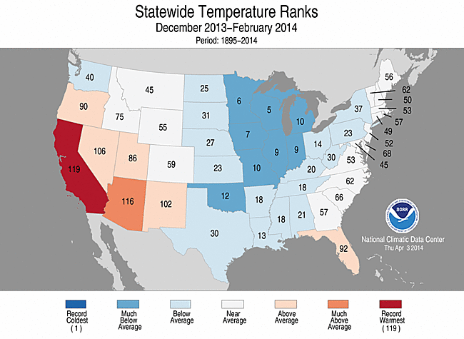
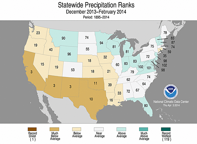
Winter 2013/14 Statewide Temperature (top)
and Precipitation (bottom) ranks
- Below-average temperatures dominated east of the Rockies, with the coldest conditions occurring across the Midwest. Numerous cold Arctic air outbreaks impacted the region during the winter season, particularly during January and February. Seven Midwestern states were much colder than average and had a top 10 cold winter season, though no state was record cold.
- The persistent cold during winter resulted in 91 percent of the Great Lakes being frozen by the beginning of the March, according to NOAA's Great Lakes Environmental Research Laboratory. This was second-largest ice cover for the Great Lakes since records began in 1973, and only surpassed by the Great Lakes ice cover in 1979.
- Above and much above average temperatures were present for Florida and much of the West. California had its warmest winter on record, while Arizona had its fourth warmest. The California winter temperature was 48.0°F, 4.4°F above the 20th century average, far exceeding the previous record, set in 1980/81, by 0.8°F.
- Much of the West and Great Plains were much drier than average. Arizona, California, New Mexico, and Texas each had a top 10 dry winter season. During winter, drought intensified across the West and Southern Plains. Statewide reservoirs in Texas averaged 64 percent capacity on February 20, their lowest level for the time of the year since 1990.
- Beneficial rainfall at the end of February provided some marginal drought relief in the far West. As of March 1, reservoirs across central and northern California had storage levels between 36 percent and 74 percent of their historical averages for the date. Locations in northern and central California would need over 18 inches of precipitation over the next three months to end the current drought, which would be highly unusual.
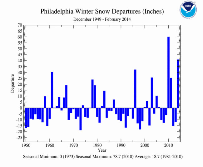
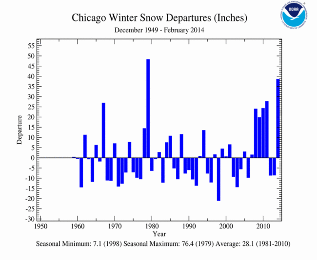
- Above-average precipitation was observed in the Northern Rockies, and parts of the Midwest, Mid-Atlantic, and Northeast. Across these regions, numerous winter storms brought heavy snowfall. Detroit had its snowiest winter on record, while New York, Philadelphia, Chicago, and Boston each had one of their ten snowiest winters. A list of snowfall totals for select U.S. cities can be found here.
- Alaska had its eighth warmest winter on record with an average temperature 6.2°F above the 1971-2000 average, marking the warmest winter for the state since 2002/03. Alaska's winter statewide precipitation total was 20.9 percent above average and the 27th wettest winter on record.
- According to NOAA data analyzed by the Rutgers Global Snow Lab, the winter average snow cover extent for the contiguous U.S. was 1.42 million square miles, which was 170,000 square miles above the 1981-2010 average. This marked the 10th largest seasonal snow cover extent in the 1966-present period of record. Above-average snow cover was observed across the northern and eastern U.S., while below-average snow cover was observed from the Southern Rockies, westward.
- The U.S. Climate Extremes Index (USCEI) during winter was above average and the 25th highest value on record for the season. Elements that contributed to the above average USCEI included the spatial extent of cold maximum and minimum temperatures and days with precipitation. The USCEI is an index that tracks extremes (falling in the upper or lower ten percent of the record) in temperature, precipitation, and drought across the contiguous United States.
U.S. climate highlights: February


- Below-average February temperatures were observed across much of the northern and central contiguous U.S., with the largest departures from normal across the Midwest. Illinois, Iowa, and Wisconsin each had a top 10 cold February, though no state was record cold.
- The Southwest and Florida were warmer than average. Arizona, California, and Utah each had February temperatures that ranked among the ten warmest on record, though no state was record warm.
- Below-average precipitation was observed across parts of the Southeast, the Northern and Southern Plains, and the Southwest. Arizona, New Mexico, and Oklahoma had February precipitation totals that were top ten dry.
- Above-average precipitation fell across the Northwest, Northern Rockies, Midwest, and parts of the Northeast. Montana and Wyoming both had a top ten wet February.
- According to the March 4 U.S. Drought Monitor report, 35.9 percent of the contiguous U.S. was in drought, down from 37.4 percent at the beginning of February. Drought conditions improved across the western Gulf Coast states, while drought intensified in the Southern Plains. Some minor drought relief occurred in the West, when a late-winter storm dropped heavy precipitation across the region, but 22.4 percent of California continued to experience the worst classification of drought, known as D4 or "exceptional", with mountain snowpack still much below average.
* With this report and data release, the National Climatic Data Center is transitioning to an improved U.S. temperature and precipitation dataset called nClimDiv. More information on this transition and how the new temperature and precipitation values compare to values previously reported this winter can be found here: