Monthly Report Summary Information
The Monthly Report Summary Information is a synopsis of the collection of national and global summaries released each month.
Global Summary Information - February 2012
See Full Report
Global temperatures 22nd warmest on record for February
February marks the 324th consecutive month of temperatures above the long-term average
The globe experienced its 22nd warmest February since record keeping began in 1880. Arctic sea ice extent was the fifth lowest extent on record for February at 6.9 percent below average. Additionally, La Niña conditions continued to weaken during February. According to NOAA's Climate Prediction Center, La Niña is expected to dissipate by the end of April.
February 2012 was the coolest February on record since 2008. However, February 2012 also marks the 324th consecutive month with a global temperature above the 20th century average. The last month with below average temperatures was February 1985.

Global temperature highlights: February
- The combined average temperature over global land and ocean surfaces for February 2012 was the 22nd warmest in the 133-year period of record and coolest since 2008, at 54.57°F (12.47°C), which is 0.67°F (0.37°C) above the 20th century average of 53.9°F (12.1°C). The margin of error associated with this temperature is ±0.20°F (0.11°C).
- Looking only at land, the global land surface temperature was 0.68°F (0.38°C) above the 20th century average of 37.8°F (3.2°C), making this the 37th warmest February on record and coolest February since 1994. It was also the coolest month on record since January 2008. The margin of error is ±0.61°F (0.34°C). Warmer-than-average conditions occurred across nearly all of Canada and Alaska, the eastern half of the United States, southern Greenland, and north central Russia. Cooler-than-average regions included northeastern Africa, most of Europe and central Asia, and much of Australia.
- For the ocean, the February global sea surface temperature was 0.65°F (0.36°C) above the 20th century average of 60.6°F (15.9°C), making it the 12th warmest February on record. The margin of error is ±0.07°F (0.04°C). The warmth was most pronounced across the north central Pacific, the North Atlantic, much of the eastern Indian Ocean, and portions of the mid-latitude Southern oceans.

Global temperature highlights: December – February
- The combined global land and ocean average surface temperature for the December–February period was 0.74°F (0.41°C) above the 20th century average of 53.8°F (12.1°C), making it the 17th warmest such period since records began in 1880 and coolest December–February since 2008. The margin of error is ±0.16°F (0.09°C).
- The December–February worldwide land surface temperature was 1.06°F (0.59°C) above the 20th century average, the 20th warmest such period on record. The margin of error is ±0.38°F (0.21°C). The global ocean surface temperature for the same period was 0.59°F (0.33°C) above the 20th century average and 15th warmest such period on record. The margin of error is ±0.07°F (0.04°C). Warmer-than-normal temperatures were observed across most of North America, most of northern Europe and Asia, and southern South America. Cooler-than-normal temperatures were felt across western and central Alaska, far eastern Russia, the Middle East, central and eastern mainland Asia, the southern half of Australia, and northwestern Africa.
Global temperature highlights: Year to date
- The combined global land and ocean average surface temperature for the January–February period was 0.67°F (0.37°C) above the 20th century average of 53.8°F (12.1°C), making it the 20th warmest such period in the 133-year period of record. The margin of error is ±0.18°F (0.10°C).
- The January–February worldwide land surface temperature was 0.77°F (0.43°C) above the 20th century average, the 33rd warmest such period on record. The margin of error is ±0.47°F (0.26°C). The global ocean surface temperature for the year to date was 0.61°F (0.34°C) above the 20th century average and was the 14th warmest such period on record. The margin of error is ±0.07°F (0.04°C).
- La Niña continued to weaken during February. According to NOAA's Climate Prediction Center, La Niña is expected to dissipate by the end of April.
Polar sea ice and precipitation highlights
- The average Arctic sea ice extent during February was 6.9 percent below average, ranking as the fifth lowest February extent since satellite records began in 1979. The five lowest February Arctic ice extents have occurred in the last seven years. February 2012 is the 14th consecutive February and the 129th consecutive month with below-average Arctic sea ice extent.
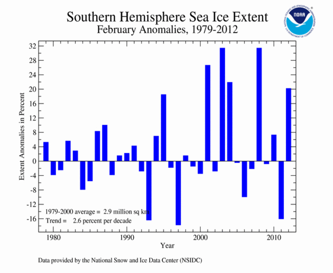
- On the opposite pole, the Antarctic sea ice extent during February was 20.3 percent above average, the fifth highest on record.
- The Northern Hemisphere snow cover extent for February was the eighth highest monthly extent in the 46-year period of record. The North American snow cover extent was the 16th lowest February extent on record, while the Eurasian snow cover was the third highest February. The Eurasian February snow cover of 12.0 million square miles (31.2 million square km) was also the fifth highest snow cover extent for the continent among all months on record.
- The snow cover extent for the Northern Hemisphere during the winter (December-February) was the 14th highest on record. The North American winter snow cover extent was the fourth lowest, partially driven by low snow totals across the contiguous United States. The Eurasian winter snow cover extent was fourth highest on record, due to the heavy snowfall observed across central and eastern Europe during January and February.
- Precipitation was variable across the globe during February. Dryness prevailed across much of Western Europe, with France reporting its driest February since 1959, Spain since 2000, and England since 1998. Rainfall was much heavier than average in southeastern Australia, with major flooding occurring in Queensland, New South Wales, and Victoria. This rainfall was associated in part with La Niña.

Included in this report: NOAA is now making it easier to find information about margins of error associated with its global temperature calculations. NCDC previously displayed this information in certain graphics associated with the report, but it will now publish these ranges in the form of .plus or minus. values associated with each monthly temperature calculation. These values are calculated using techniques published in peer-reviewed scientific literature.