During April, above-average temperatures were observed across the eastern U.S. with near- to below-average temperatures across much of the West. Above-average precipitation fell across most of the nation, particularly the Northwest, Great Plains, and Midwest to Mid-Atlantic. According to NOAA's National Snow Analysis, on April 1st, 14.8 percent of the contiguous U.S. had snow on the ground — mountain areas of the West, and northern areas of the Northeast. On April 17th, only 5.6 percent of the contiguous U.S. had snow on the ground, the lowest extent during the month. By April 30th, snow covered 13.9 percent of the Lower 48 — the highest elevations in the West and the central High Plains. Of note, snow was gone for most locations in the Northeast by the end of the month. However, 12 inches of snow was observed on the ground for Caribou, Maine on April 10th, the last day of a record-long 32-day consecutive day stretch with at last one foot of snow on the ground.
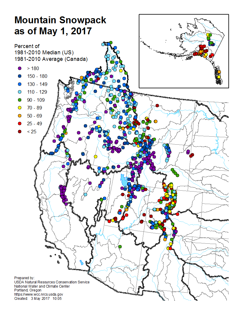
Melting of winter and spring mountain snowpack provides a crucial summer water source across much of the western United States. The total annual water budget for agriculture and human use in the mountainous West is highly dependent on the amount of snow melt that will occur in spring and is proportional to the amount of snow on the ground. As a result of late-winter storms in the Northwest and Northern Rockies and earlier-season snowfall to the south, most mountain locations in the West had near- to above-average snowpack as of May 1st. Much-average-average snowpack was observed for the Sierra Nevada Mountains, the central and southern Cascades, and much of the Great Basin to Central Rockies. Near- to below-average snow pack was observed from the Southern Rockies into parts of Colorado. In Alaska, a dry and warm April resulted in most locations across southern parts of the state to have below-average snowpack. Most of central Alaska had near-average snowpack totals.
Significant Events
During the last days of April and early May, a potent storm system moved from the West Coast, through the Central Rockies and into the Great Plains. As the storm exited the Rockies, heavy snow and blizzard conditions were observed on the western and northern edges of the system from the Southern Rockies, High Plains, and into the Upper Midwest. In the Colorado Rockies snowfall totals exceeding 30 inches in some locations with the heaviest snowfall extending into the High Plains with over a foot of snow in parts of Kansas, Nebraska, Oklahoma, and Texas. The biggest impacts to the snow were closed highways and airport delays. Flooding and severe weather were also associated with the same storm system further to the south and east.
 NOAA's National Centers for Environmental Information


