
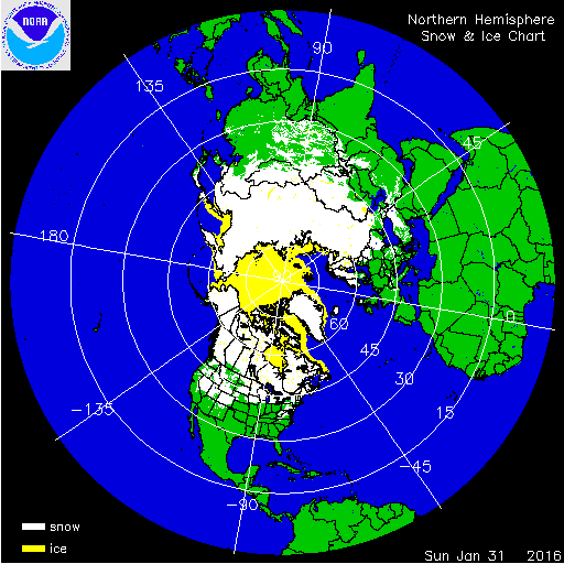
The 2015/16 winter season (December 2015-February 2016) began with a record warm December for the CONUS as 29 states experienced their warmest December on record. The winter ended with the eighth warmest February as above-average temperatures were widespread across the western half of the contiguous U.S. as well as parts of the Midwest and Northeast. For the season as a whole, forty-six states across the contiguous U.S. had a winter temperature that was above average. Much-above average winter temperatures were observed across the Great Plains, Midwest, Southeast, Northeast, and parts of the West. Six states in the Northeast had a winter temperature that was record warm. Binghamton and Albany, New York both had their least snowy winter on record. Wichita, Kansas had its 3rd least snowiest winter on record. On the other hand, Cheyenne and Casper, Wyoming both had their 6th snowiest winter on record. Dry and warm conditions at the end of winter depleted snowpack in much of the West. Sierra Nevada snowpack fell from 116% to 83% of average during February. While a majority of basins in the Intermountain West reported near-normal snowpack, percentages in the Sierra fell during February.

A strong El Niño and a positive Arctic Oscillation played a large role in the winter snowpack across the Lower-48. At the start of the season, a large ridge dominated the weather pattern along the eastern half of the country in December, deflecting the frontal passages which typically provide cold, moist air. Much warmer-than-normal to record warm temperatures persisted all month in the central and eastern CONUS. Conversely in the West, an active northerly jet in the upper atmosphere allowed several systems to slam the Northwest Pacific coastline, providing near-to-cooler-than-normal temperatures and welcomed mountain snowfall. At the end of December, snow cover was above normal for much of the western half of the U.S. Meanwhile, much of the Midwest and Northeast had below-normal snow cover.
In January, the stream of Pacific weather systems continued to push into the western U.S., bringing above-normal precipitation to many areas. Where temperatures were cold enough, precipitation fell as snow, building up the much-needed mountain snowpack. For the month of January, much of the West, Southwest, Midwest, and Mid-Atlantic had above-normal snow cover. It was the seventh largest January snow cover extent for the CONUS (based on satellite records).
The season ended with a strong ridge in the West, inhibiting precipitation and allowing temperatures to be near record warm in the region. As a result, much of the western and central U.S. was warmer and drier than normal in February. This helped to contract the CONUS snow cover to 15-25 percent by the end of the month, the 13th smallest on record. Conversely, the east coast was generally wetter than normal thanks to a moist flow from the Gulf of Mexico and North Atlantic.
In Alaska, the snow cover extent was below average for the winter; however, the heavy snows that fell in the autumn of 2015 helped boost the late winter snowpack across the state. Below-average snowpack was observed across southern parts of the state, where record warmth was observed during March, while above-average snowpack was observed across interior locations. In April, record-warmth limited the snowpack across much of Alaska with snowpack totals less than 25 percent of average across central and southern regions of the state.
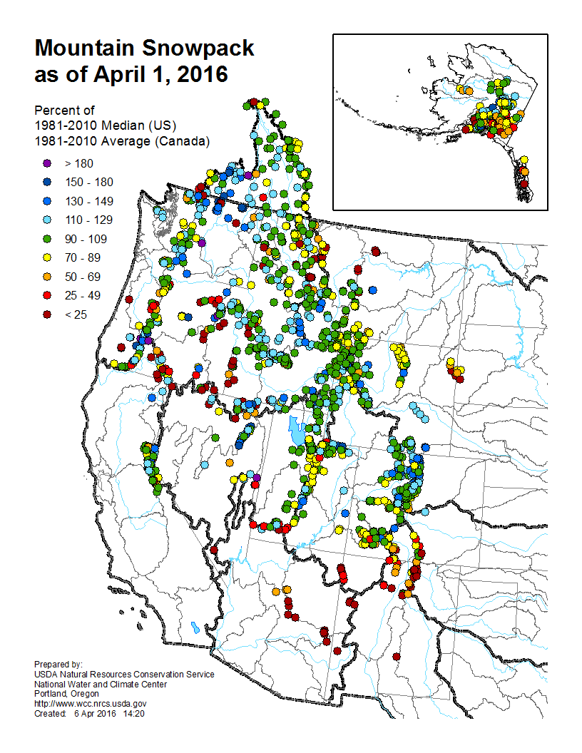
Winter and spring mountain snowpack provide a crucial warm season water source across much of the western United States. The total annual water budget for agriculture and human use in the mountainous West is highly dependent on the amount of snow melt that will occur in spring and is proportional to the amount of snow on the ground. The annual snowpack typically peaks in early April. At the beginning of April, most locations from the Rockies to the Sierra Nevada had near-average snowpack. In the Southern Rockies, snowpack totals were less than 25 percent of normal. For parts of California, this was the first above-normal snowpack season since 2011, providing much needed water resources going into the warm and dry season. It would be later in the year when the runoff melt from the snowpack, along with summer and fall rains, would attribute to a positive gain in reservoir levels across the West.
For additional information on specific events please visit our monthly reports, storm events database, and billion-dollar weather disasters report.