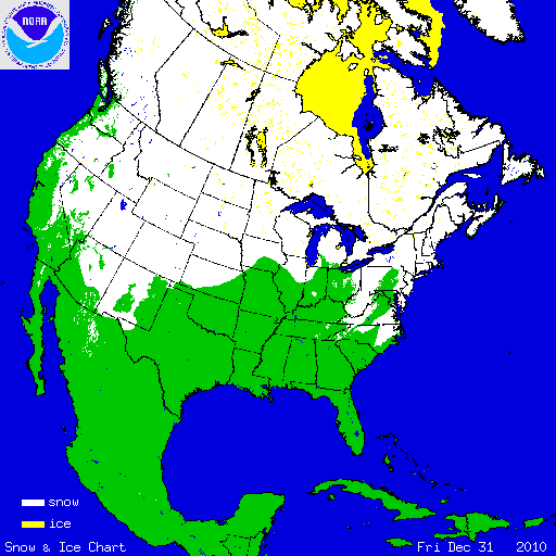
December brought near normal temperatures and precipitation when averaged over the entire U.S., but there was significant regional variability. The West and Southwest were warmer than average while the Northern Plains, Midwest, Mid-Atlantic, and Southeast were cooler than average. Precipitation amounts were also mixed across the country, with drier-than-average conditions for the South, Southeast, and Ohio River Valley, while it was a wet month for the West, Northern Plains, and parts of the Northeast. These conditions led to above average snow cover during December; the month ranked as the seventh largest December snow cover extent for bthe contigous U.S. on record (out of 45 years). According to the Rutgers Global Snow Lab, a NOAA supported facility, the monthly snow cover extent was 0.9 million square km (347,500 square miles) above the long term average of 2.9 million square km (1.1 million square miles). Above average snow extent occurred across the eastern and northern regions and intermountain west; below-average snow fell across the Southern and Central Plains. At the beginning of the month, 34.2 percent of the country was under snow cover — the high elevations of the West, the Northern Plains, and northern New England. Several winter storms impacted the U.S. during December increasing the amount of the country under snow to a monthly maximum of 55 percent on the 27th. On the last day of the month, 51 percent of the country was under snow — the higher elevations of the West, the Northern Plains, the Great Lakes, the central and southern Appalachians, the Mid-Atlantic Coast and most of the Northeast.
Select December 2010 Monthly Snowfall Records
| City | December 2010 Accumulation | Previous Record | Additional Comment |
| Syracuse, New York | 72.7 inches | 70.3 inches - December 2000 | 2nd snowiest month on record |
| Rochester, New York | 46.5 inches | 46.2 inches - December 2008 | Records date back to 1884 |
| Watertown, South Dakota | 29.0 inches | 25.0 inches - December 2009 | |
| Aberdeen, South Dakota | 24.6 inches | 24.1 inches - December 1927 | |
| Williston, North Dakota | 35.0 inches | 32.0 inches - December 2008 | |
| Jackson, Kentucky | 18.5 inches | 17.6 inches - December 2009 | |
| Beckley, West Virginia | 47.3 inches | 37.7 inches - December 2009 | 3rd snowiest month on record |
| Minneapolis, Minnesota | 33.4 inches | 33.2 inches - December 1969 | Records date back to 1871 |
| Mammoth Mountain, California | 139.8 inches | 140 inches - December 1971 |

A strong blizzard hit Minnesota, Iowa, and Wisconsin on December 10th through 12th, bringing over a foot of snow to the region and sustained winds of 35 mph (56 km/hr). The 17 inches (43 cm) of snow that fell in Minneapolis was the 5th largest snowstorm ever for the city and the largest December snowfall on record. Minneapolis set a new December snowfall record with a monthly total of 33.6 inches (86 cm), the previous December record was set in 1969 when 33.2 inches (85 cm) of snow was reported. Data for the city goes back to 1884. The 22 inches (56 cm) which fell in Eau Claire, Wisconson on the 11th is the highest single calendar day snowfall total in history. An unusual aspect of the storm was the high snow-to-water equivalent of 9:1, which represents how heavy the snow was. The heavy nature of the snow, as well as the amount and strong winds, contributed to the collapse of the Metrodome roof, home to several professional sports teams. Fortunately the building was empty, and no one was injured.

During December a series of storms made landfall along the Pacific Coast, bringing with them a surge of moisture from the tropics often referred to as an atmospheric river or the 'Pineapple Express' since the deep moisture originates near Hawaii. The first storm impacted the Pacific Northwest on December 11th-12th, bringing heavy snowfall and rain. Daily rainfall records were broken in Seattle and flooding was widespread in Washington. The second system brought a significant influx of moisture to Southern California, Arizona, Colorado, Nevada, and Utah on December 19th through 22nd. Daily and monthly precipitation records were broken across the region. In California, snow accumulation up to 17 feet (5.2 meters) was reported in Sequoia National Park as well as 26 inches (660 mm) of rainfall in Crestline, California and a wind gust of 68 mph (110 km/hr). For the month, 10.23 inches (260 mm) of rain was reported in Downtown Los Angeles, marking the second wettest December on record behind December 1889 when 15.8 inches (401 mm) of rain fell in the city. Records in Los Angeles date back to 1877. Mammoth Mountain in California received 208 inches (528 cm) of snow for the month, breaking the previous December record of 139.8 inches (356 cm) which fell during December 1971. According to the resort website, the snow during the month caused Mammoth Ski Resort have more snow on the ground than any other ski resort in the world. The heavy rain and snow in the region caused Nevada and Utah to have their wettest December on record; while California and Oregon both had a top ten wet December. The same system moved into the Northern Plains of the U.S. causing blizzard conditions for the Dakotas and western Minnesota the last two days of the month. Wind gusts over 45 mph (72 km/hr) were reported and snowfall amounts over a foot (30 cm) were widespread over the Northern Plains. The same system was responsible for a significant tornado outbreak for central and southern parts of the country. See the December tornado report for more information.

24-28 December Snowfall
A low pressure system moved across the southern U.S. and interacted with another system moving from the Northern Plains the last week of December. The two systems brought widespread snowfall from Minnesota, southward to Alabama and Georgia and along the Eastern Seaboard to Maine on December 24th through 28th. Many locations in the Southeast experienced their first white Christmas on record, and many cities broke daily snowfall records because of the storm. As the system moved up the Atlantic Coast, it strengthened bringing heavy snowfall to the major cities in the Northeast. Central Park in New York City received 20 inches (51 cm) of snow, marking the sixth largest snowfall there, while Boston received 18.2 inches (46 cm), the city’s eight biggest snow storm on record. The 20.1 inches (52 cm) which fell at the Atlantic City International Airport was a single snowstorm record. In Philadelphia, the 12.4 inches (32 cm) gave the city 67.3 inches (171 cm) of snow for the 2010 calendar year, the largest January–December snowfall amount on record, ahead of the 57 inches (145 cm) which fell in 1978. The preliminary NESIS score, which measures the impact of snow on population centers, was a Category 3 (major).