The two satellite-derived images above show the daily snow cover across North America (left map) and the Northern Hemisphere (right map) throughout April 2009. Spurred on by warm springtime temperatures, the extent of the snow cover across the U.S. contracted northward throughout the month. On April 6, the area covered by snow was 30 percent and decreased by 5 percent each of the next three days. By the end of the month only 7 percent of the country was covered in snow, most of which was concentrated in the Northern Rockies.
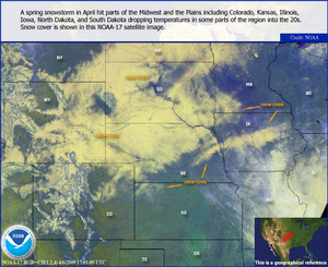
Parts of the Front Range received blizzard-like snowfall from a surface low over Colorado that collided with an upper level system in the four-corners region on April 4. The heavy snow amounts across eastern Wyoming, northern Nebraska and South Dakota was attributed to a strong easterly upslope flow. The heaviest snow fell in the northwest corner of Nebraska, where areas around Chadron and Harrison reported 17-24 inches with 8-15 foot drifts.
During the 2008-09 winter season, several seasonal snowfall totals were noteworthy. International Falls, Minnesota, recorded 125 inches of snow, which broke a season snowfall record. The previous record of 116 inches was set during the 1995-96 season. The 97.7 inches of snow in Spokane, Washington, surpassed the previous record of 93.5 inches set in 1915-16. Bismarck, North Dakota received 100.3 inches of snow, only 1.3 inches shy of the record set during the 1996-97 season. The snowy trend continued in Youngstown, Ohio, which recorded 86.5 inches. Based on records that date back to 1948, the northeastern Ohio town has experienced its three snowiest seasons in the past three years (90.2 inches in 2006-07 and 102.8 inches in 2007-08). The winter season in the U.S. is defined as July 1 - June 30.
The rest of the month was relatively quite as most of the snow events were confined to the Northern Rockies. By the end of April the snowpack levels were at or slightly above normal for the Pacific Northwest. Some areas along the Oregon Coast Range and the Cascade Range of Washington received more than 200 percent of 1971-2000 snowfall normal. In contrast, the Sierra Nevada snowpack levels were as much as 50 percent below normal resulting in the third consecutive year of below average runoff. The Front Range of Colorado and much of the Rocky Mountains received some much needed late season snowfall that placed them around near normal levels for the season. The southern Rockies were not as fortunate, as some of those areas received less than 25 percent of normal snowfall this season. The runoff from the snowfall is a main component of annual water supply levels.
 NOAA's National Centers for Environmental Information


