National Overview

November Highlights
November Temperature
- The contiguous U.S. average temperature during November was 41.0°F, 0.7°F below average, ranking in the middle third of the record.
- Generally, temperatures were above average from the Midwest to the Northeast and Southeast, and below average from the Plains to the West Coast.
- For the month of November, Maine fifth warmest on record while Florida ranked seventh warmest, with five additional states experiencing a top-10 warmest November on record. Conversely, temperatures were below average to record coldest across much of the West. Idaho ranked fourth coldest, Washington ranked sixth and Oregon ranked seventh, while two additional states each had their top-10 coldest November on record.
- The contiguous U.S. average maximum (daytime) temperature during November was 51.9°F, 0.8°F below the 20th century average, ranking in the coldest third of the record. Near-average to record-warm maximum temperatures were observed across much of the eastern U.S. from the Mississippi Valley to the East Coast. New Hampshire, Maine, Massachusetts, Vermont, Connecticut and Rhode Island ranked second through seventh warmest on record, respectively, for daytime temperatures. Daytime temperatures were below average from the West Coast to the Plains. Washington ranked eighth coldest on record while Montana, Idaho and Nevada each ranked 11th coldest for this period.
- The contiguous U.S. average minimum (nighttime) temperature during November was 30.0°F, 0.7°F below the 20th century average, ranking in the coldest third of the record. Minimum temperatures were near to above average from the southern Plains to the Upper Midwest and to the East Coast. Florida ranked fifth warmest while North Carolina and South Carolina each ranked ninth warmest on record for November nighttime temperatures. Nighttime temperatures were below-average across much of the West. Idaho ranked sixth coldest, Nevada ranked seventh coldest and Montana ranked eighth coldest on record for nighttime temperatures.
- The Alaska statewide November temperature was 16.3°F, 4.6°F above the long-term average. This ranked in the warmest third of the 98-year period of record for the state. Temperatures were above average across much of northern Alaska, the Yukon Delta, the Aleutians and parts of the eastern Interior. South central Alaska and areas along the Gulf of Alaska to the Panhandle experienced near-average conditions, while the southern Panhandle experienced below-average temperatures for the month.
- Based on data received on December 7, there were 4,146 record warm daily high (2,182) and low (1,964) temperature records tied or broken during November. This was slightly less than the 4,972 record cold daily high (2,660) and low (2,312) temperature records.
- Based on NOAA's Residential Energy Demand Temperature Index (REDTI), the contiguous U.S. temperature-related energy demand during November was 79 percent of average and the 38th-lowest value in the 128-year period of record.
November Precipitation
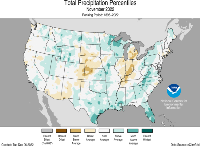
- The November precipitation total for the contiguous U.S. was 2.40 inches, 0.17 inch above average, ranking in the middle third of the historical record.
- Precipitation was above average from the Great Lakes to the southern Plains, from the Gulf Coast to the Northeast and across portions of the Great Basin, northern Rockies and northern Plains. Precipitation was below average across southern Michigan to the Ohio Valley and in the central Plains.
- November precipitation was near- to above-average over much of the contiguous U.S. with much of the area experiencing near- to above-average precipitation. Precipitation was below average in parts of the Southwest, central Plains, Ohio Valley and Great Lakes. No state experienced a top-10 wettest or driest November.
- Monthly precipitation averaged across the state of Alaska was 3.37 inches, 0.02 inches below average, ranking in the middle third of the 98-year record. Conditions were wetter than average across the North Slope, central Interior, West Coast and in portions of the Aleutians while much of eastern Alaska and northern parts of the Panhandle experienced near-average conditions. Southern areas of the Panhandle had below-average precipitation for the month.
- According to the November 29 U.S. Drought Monitor, about 57.5% of the contiguous U.S. was in drought, down about 5.3% from the beginning of November. Drought conditions expanded or intensified across portions of the Southeast, Great Lakes, Upper Midwest and central Plains. Drought contracted or was eliminated across portions of the Northwest, northern and southern Plains, Mississippi Valley and parts of the Northeast and Hawaii.
Other Notable Events
- November had several notable storms that brought severe thunderstorms and tornadoes to portions of the United States:
- On November 4-5, a tornado outbreak occurred across portions of Texas, Oklahoma, Louisiana and Arkansas. A total of 31 tornadoes were confirmed by the National Weather Service, including two EF-4 tornadoes, which brought significant damage to the region including mass power outages.
- On November 29-30, severe storms and tornadoes swept through parts of the South, downing trees, damaging homes in parts of Alabama and Mississippi. The National Weather Service confirmed 11 tornadoes during this outbreak including two EF-3 tornadoes.
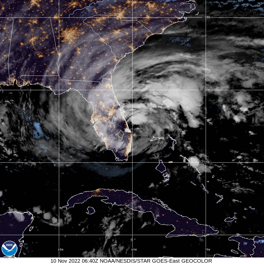
- On November 10, Hurricane Nicole made landfall along Florida’s eastern shore, flooding the coast and knocking out power to thousands. Nicole was the first hurricane to hit the United States in November in nearly 40 years.
- On November 7-10, a winter storm brought heavy snow and strong winds across much of the West. Parts of Washington, California, Montana and North Dakota reported between one to three feet of snow.
- Northern Washington reported up to 2 feet of snow.
- Mammoth Mountain, California reported 32 inches of snow.
- Yellowstone, Montana reported 22 inches of snow.
- Bismarck, North Dakota, reported 20 inches of snow, making it their second-highest daily snowfall total on record.
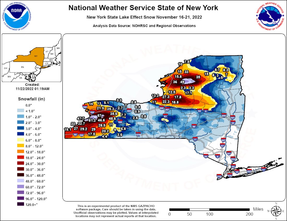
- A historic snowstorm slammed western and northern New York on November 16-20 with more than six feet of snow reported in some areas, closing roads, triggering driving bans and canceling flights. The city of Buffalo set a record for daily snowfall, with 21.5 inches on Saturday, November 19. The previous record was 7.6 inches. The State Climate Extremes Committee is investigating whether or not a new New York state 24-hour snowfall record has been set.
- On November 27, Mauna Loa, the world's largest active volcano, located on the Big Island of Hawaii, erupted for the first time in 38 years.
Fall Highlights
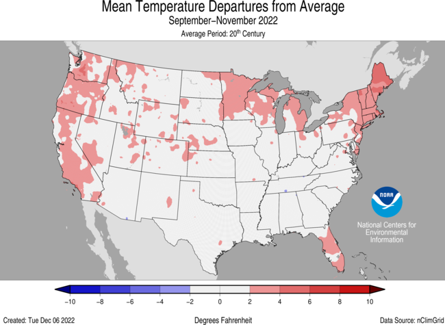
September-November Temperature
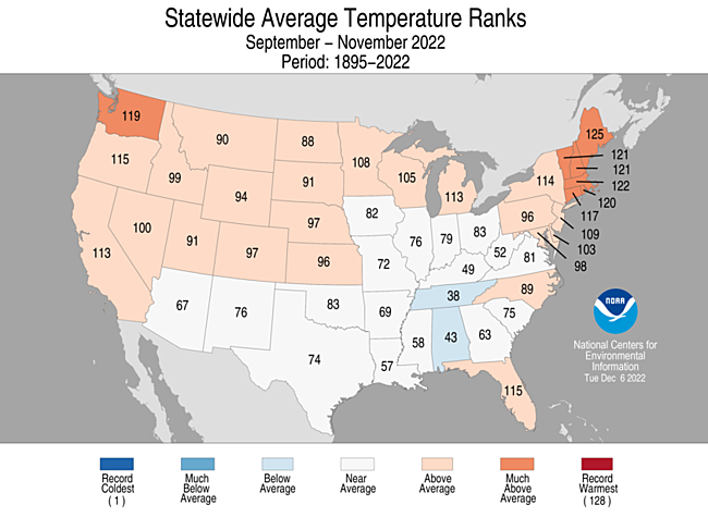
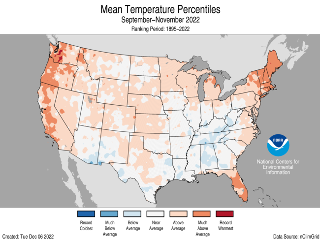
- The meteorological autumn (September-November) average temperature for the Lower 48 was 54.7°F, 1.2°F above average, ranking in the warmest third on record.
- Autumn temperatures were above average from the West Coast to the Great Lakes and into the Northeast as well as along portions of the East Coast. Temperatures were near- or below-normal in parts of the Southwest, the southern Plains, and from the southern and central Mississippi Valley to the Ohio Valley and Southeast. Maine ranked fourth warmest while five additional states ranked among their warmest 10 autumn seasons on record.
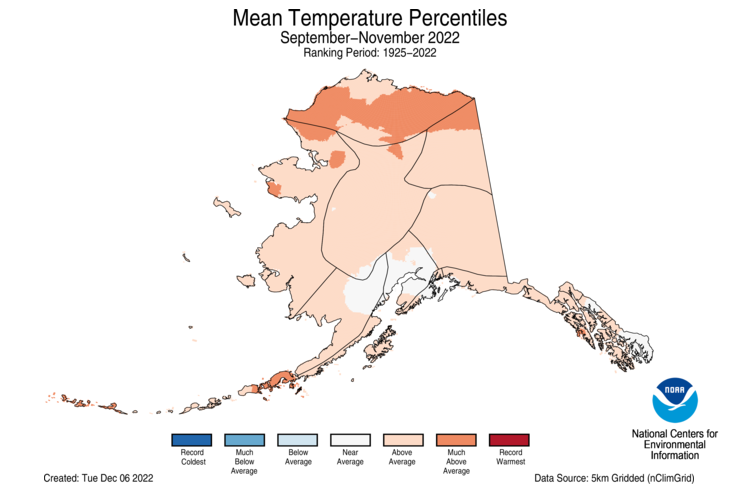
- The Alaska autumn temperature was 29.2°F, 3.3°F above the long-term average, ranking 18th warmest on record for the state. Temperatures were above average across most of the state with the central Interior region near average for the season.
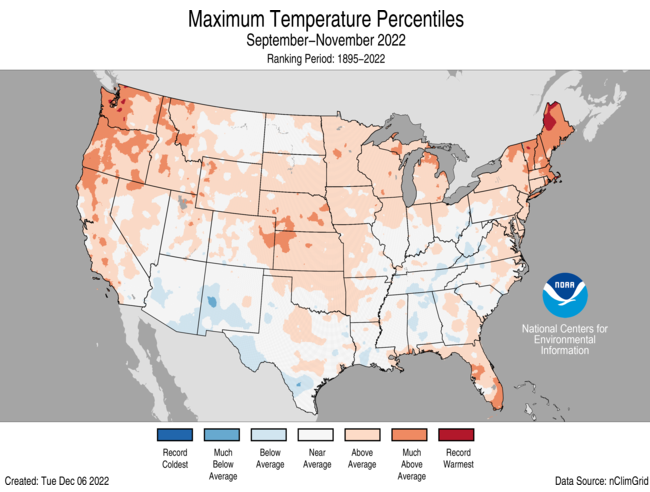
- The contiguous U.S. average maximum (daytime) temperature during September-November was 67.2°F, 1.4°F above the 20th century average, ranking in the warmest third of the record. Above-average daytime temperatures were observed across much of the contiguous U.S. Temperatures were near to or below average across portions of the northern Rockies and Plains and from the Southwest to the southern Plains and from the southern Plains to the Ohio Valley and Southeast. Maine ranked second warmest, Washington ranked sixth warmest and Vermont ranked seventh warmest for this period.
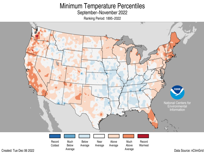
- The contiguous U.S. average minimum (nighttime) temperature during September-November was 42.3°F, 0.9°F above the 20th century average, ranking in the warmest third of the record. Nighttime temperatures were above average across much of the West and Northeast and in portions of the northern Plains, Upper Midwest, Great Lakes and Southeast. Maine and Massachusetts each ranked seventh for warmest on record for September-November nighttime temperatures. Temperatures were near to below average across much of the central Plains to the Ohio Valley and Gulf Coast and in parts of the northern Rockies and Plains.
- Based on REDTI, the contiguous U.S. temperature-related energy demand during the autumn season was 79 percent of average and the 40-lowest value on record.
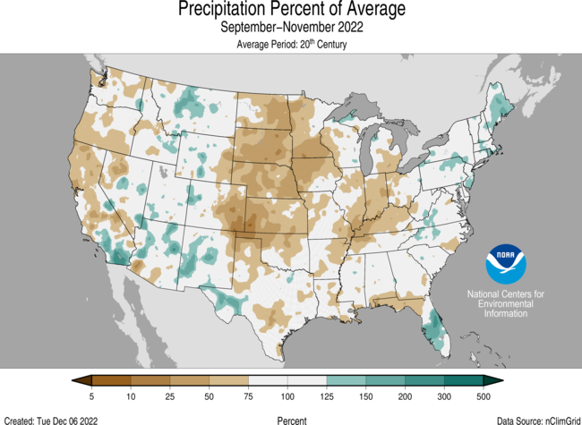
September-November Precipitation
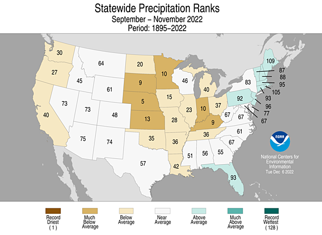
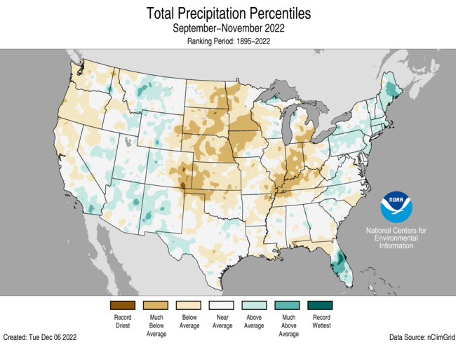
- The U.S. autumn precipitation total was 5.92 inches, 0.96 inch below average, ranking in the driest third of the September-November record.
- Precipitation was above average across parts of the Rockies, Southwest and East Coast. Precipitation during September-November was below average along the West Coast and from the northern and central Plains to the Great Lakes and Ohio River Valley. Nebraska ranked fifth driest while four additional states experienced a top-10 driest autumn season on record.
- For the autumn season, precipitation ranked 12th wettest across Alaska with wetter-than-average conditions observed across most of the state. Parts of the central Interior, Aleutians and southern Panhandle experienced near average precipitation for this period.
Extremes
-
The U.S. Climate Extremes Index (USCEI) for the autumn season was 37 percent below average, ranking in the bottom third of the 113-year period of record. There were elevated extremes in the spatial extent of dry PDSI. The USCEI is an index that tracks extremes (falling in the upper or lower 10 percent of the record) in temperature, precipitation and drought across the contiguous United States.
- On the regional scale, the Northwest region had a CEI value that ranked in the top one-third of the historical record for the season. The Northwest experienced elevated extremes in warm maximum temperatures and record high extremes in one-day precipitation during the season. In contrast, extremes were below average across much of the contiguous U.S. The Ohio Valley was 84% below average and the Southeast was 75% below average ranking as their second and sixth lowest season on record, respectively.
Year-to-Date Highlights
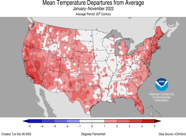
January-November Temperature
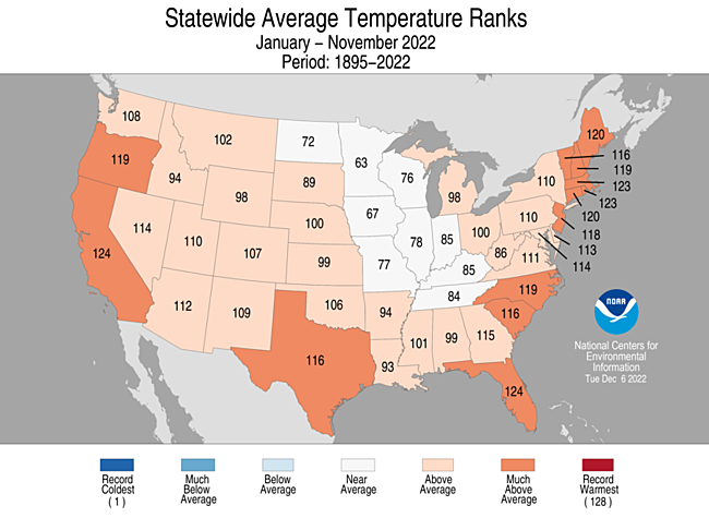
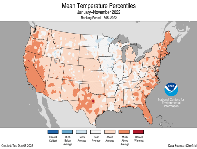
- For the January-November period, the average contiguous U.S. temperature was 55.2°F, 1.5°F above average, ranking 17th warmest in the 128-year record. Temperatures were above average from the West Coast to the Gulf Coast and from the Gulf to New England. California and Florida each ranked fifth warmest while Massachusetts and Rhode Island each had their sixth warmest January-November period on record. Five other states ranked among their warmest 10 such year-to-date periods on record. Temperatures were near average from the northern Plains and Upper Midwest to the Tennessee Valley.
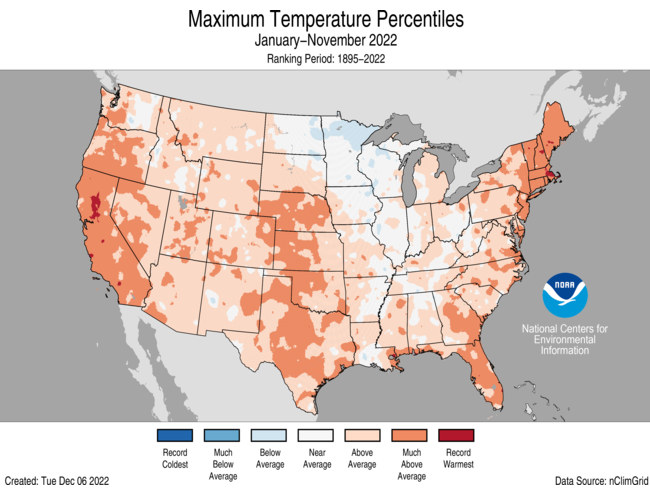
- The contiguous U.S. average maximum (daytime) temperature during January-November was 67.7°F, 1.8°F above the 20th century average, ranking 14th warmest in the historical record. Temperatures were above average across most of the Lower 48 with the exception of portions of the Upper Midwest. Massachusetts ranked fourth warmest while California, Florida, Maine and Vermont each ranked fifth warmest for daytime temperatures during January-November. Eight additional states experienced a top-10 warmest event for this 11-month period.
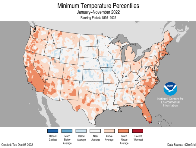
- The contiguous U.S. average minimum (nighttime) temperature during this 11-month period was 42.7°F, 1.1°F above the 20th century average, ranking in the warmest third of the record. Nighttime temperatures were above average across much of the West, southern Plains and eastern U.S. Florida ranked sixth warmest and California ranked ninth warmest while Massachusetts and Rhode Island each ranked 10th warmest on record for nighttime temperatures. Nighttime temperatures were near to or below average across portions of the central U.S.
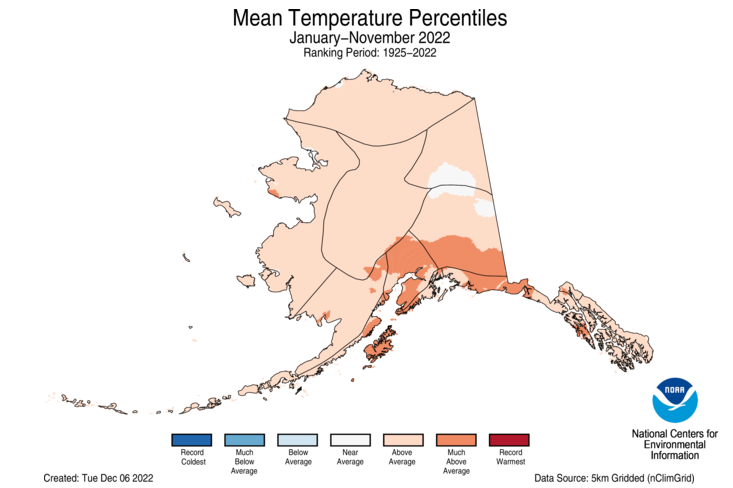
- The Alaska January-November temperature was 30.7°F, 2.7°F above the long-term average, ranking 15th warmest on record for the state. Above-average temperatures were observed across the vast majority of the state for this 11-month period.
- Based on REDTI, the contiguous U.S. temperature-related energy demand during January-November was 103 percent of average and was the 63rd-lowest value on record.
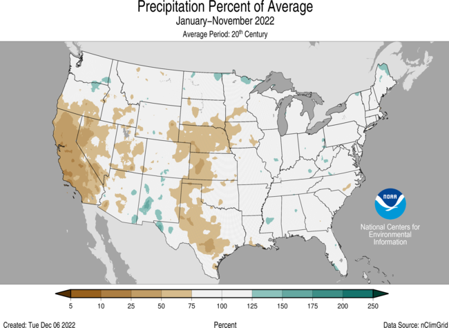
January-November Precipitation
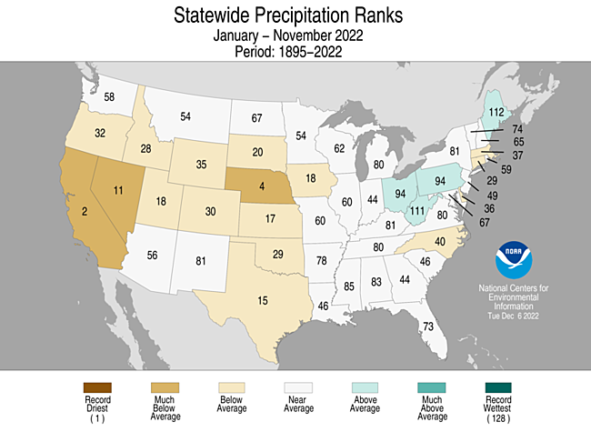
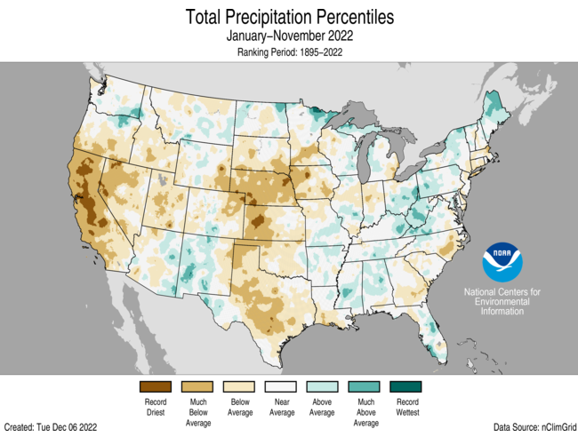
- The January-November precipitation total for the contiguous U.S. was 25.61 inches, 1.98 inches below average, ranking in the driest third of the historical record.
- Precipitation was above average across portions of the Northeast, Great Lakes, Ohio Valley, southern Mississippi Valley, and in parts of the Rockies and Northwest.
- Precipitation was below average across much of the West, central and southern Plains and parts of the East Coast during the January-November period. California ranked second-driest on record while Nebraska ranked fourth driest and Nevada ranked 11th driest for this 11-month period.
- The January-November precipitation ranked wettest on record for Alaska, with above-average to record high precipitation observed across much of the state. The central and northeast Interior regions were near-average while much of the Aleutians experienced below-average precipitation for this period.
Extremes
- The U.S. Climate Extremes Index (USCEI) for the year-to-date period was 6 percent above average and ranked in the middle third of the 113-year period of record. Extremes in warm maximum temperatures as well as dry PDSI were the major contributors to this elevated CEI value. The USCEI is an index that tracks extremes (occurring in the upper or lower 10 percent of the record) in temperature, precipitation and drought across the contiguous United States.
- On the regional scale, the West, Northern Rockies and Plains, Northeast and Southeast ranked above average for this year-to-date period. All of these regions experienced elevated extremes in warm maximum temperatures. The West, Northern Rockies and Plains, Southeast and South also experienced elevated extremes in dry PDSI. Conversely, extremes across the Upper Midwest were 62 percent below average ranking as their 16th lowest season on record.
Monthly Outlook
- According to the November 30 One-Month Outlook from the Climate Prediction Center, areas from the Southwest to Florida and across western and northern Alaska favor above-normal monthly mean temperatures in December, with the greatest odds in Northwest Alaska. The best chances for below-normal temperatures are forecasted from the Pacific Northwest to the Great Lakes. Much of the Northwest, portions of the Ohio and Tennessee valleys as well as northwestern Alaska are favored to see above-normal monthly total precipitation. Below-normal precipitation is most likely to occur across the southern high Plains and portions of the Southeast. Drought is likely to persist across much of the West, Plains, and portions of the Great Lakes and Gulf Coast. Some improvement and/or drought removal is likely to occur across portions of the southern Plains, southern Mississippi Valley to the Ohio Valley and portions of the Northwest and Hawaii. Drought development is likely across portions of the Southeast.
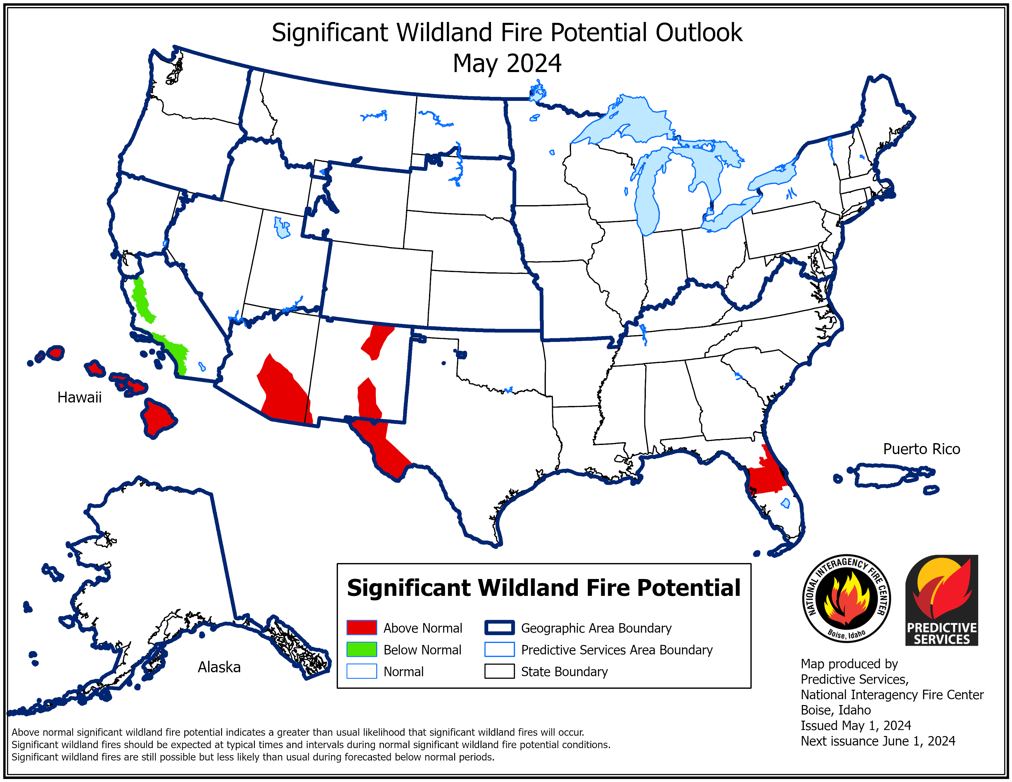
- According to the One-Month Outlook issued on December 1 from the National Interagency Fire Center, the contiguous U.S. and Alaska are expected to be near normal while the islands of Hawaii have above normal significant wildland fire potential during December.
Regional Highlights
These regional summaries were provided by the six Regional Climate Centers and reflect conditions in their respective regions. These six regions differ spatially from the nine climatic regions of the National Centers for Environmental Information.
Northeast Region (Information provided by the Northeast Regional Climate Center)
November and Autumn featured unusual warmth and below- to near-normal precipitation for many parts of the Northeast.
- Temperature
The Northeast had its 12th warmest November in 128 years of recordkeeping with an average temperature of 42.8 degrees F, 3.4 degrees F above normal. State average temperature departures for November ranged from 1.7 degrees F above normal in West Virginia to 4.6 degrees F above normal in Maine and New Hampshire. November 2022 ranked among the 20 warmest Novembers on record for all 12 Northeast states except West Virginia: Massachusetts and New Hampshire, second warmest; Maine, third warmest; Connecticut, Rhode Island, and Vermont, fifth warmest; Delaware, eighth warmest; New York, 11th warmest; Maryland, 12th warmest; New Jersey, 13th warmest; and Pennsylvania, 18th warmest. From November 5 to 7, five (of the Northeast’s 35) major climate sites experienced their warmest November day on record, while 17 major climate sites recorded their warmest low temperature for November. The first fall frost (minimum temperature of 32 degrees F or lower) at Islip, New York, occurred on November 15, tying as its latest date on record and making it the site’s longest frost-free season at 229 days. Multiple sites saw a record number of days this November with a high of at least 70 degrees F, including Dulles Airport, Virginia, and Philadelphia, Pennsylvania, with 10 days. For more information on the unusual warmth, see the Notable Weather Events section. The Northeast experienced its 15th warmest autumn since 1895 with an average temperature of 51.5 degrees F, 1.1 degrees F above normal. State average temperatures for autumn ranged from 0.9 degrees F below normal in West Virginia, the sole cooler-than-normal state, to 2.9 degrees F above normal in Maine, its third warmest autumn. This autumn also ranked among the 20 warmest on record for eight additional states: Massachusetts and New Hampshire, sixth warmest; Vermont, eighth warmest; Rhode Island, ninth warmest; Connecticut, 11th warmest; New York, 14th warmest; New Jersey, 17th warmest; and Delaware, 20th warmest.
- Precipitation
The Northeast received 2.99 inches of precipitation during November, which was 86 percent of normal. November precipitation for the 12 Northeast states ranged from 48 percent of normal in Rhode Island to 100 percent of normal in West Virginia. This November was among the 20 driest since recordkeeping began for three states: Rhode Island, 15th driest; Massachusetts, 19th driest; and Connecticut, 20th driest. Autumn precipitation for the Northeast was 11.08 inches, 95 percent of normal. Nine Northeast states wrapped up autumn on the dry side of normal, with precipitation for all 12 states ranging from 81 percent of normal in Maryland to 109 percent of normal in Maine.
- Drought
The U.S. Drought Monitor from November 1 showed less than 1 percent of the Northeast in severe drought, 2 percent in moderate drought, and 19 percent as abnormally dry. The remnants of Hurricane Nicole reversed a drying trend in much of New York, Pennsylvania, Maryland, and West Virginia. Severe drought eased in southeastern New York, while moderate drought eased in western West Virginia. Abnormal dryness shrank in coverage in those states, as well. However, coastal areas were generally drier than normal, allowing drought and dryness to persist, or even expand in a few locations. For instance, severe drought lingered in northeastern Massachusetts, while moderate drought continued on Long Island, New York, and abnormal dryness was introduced in southern Rhode Island. The U.S. Drought Monitor from November 29 showed less than 1 percent of the Northeast in severe drought, 2 percent in moderate drought, and 9 percent as abnormally dry. A few impacts from the dry conditions were noted in November. Communities such as Peabody and Ipswich, Massachusetts, and Norwalk, Connecticut, continued to have water restrictions in place due to low reservoir levels. In New England, Christmas tree saplings died and some mature trees had brown needles and bare spots, causing some farms to not fully open and growers to raise prices. Summer drought reduced grain yields in parts of Pennsylvania. Warm, dry, windy conditions helped fuel several wildfires in Pennsylvania and around 20 wildfires in West Virginia, with a few of the fires each charring hundreds of acres.
- Notable Weather
The first week of November was unusually warm in the Northeast, ranking as the warmest November 1 to 7 period on record for multiple sites. High temperatures from November 5 to 7 generally ranged from 64 degrees F to 81 degrees F. Twenty-four of the Northeast’s 35 major climate sites experienced one of the 10 warmest November days on record. In fact, five major climate sites saw their warmest November day on record. Some sites even recorded multiple days that ranked among their 10 warmest for November. For example, Bridgeport, Connecticut, had its warmest November day (79 degrees F on November 7), its eighth warmest (73 degrees F on November 5), and its ninth warmest (72 degrees F on November 2 and 6). Low temperatures on November 5 and 6 generally ranged from 54 degrees F to 67 degrees F. All but two of the region’s 35 major climate sites had one of their 10 warmest low temperatures for November. In fact, nearly half of the sites, 17 of them, recorded their warmest low temperature for November. At multiple sites, low temperatures on both days ranked among the 10 warmest for November on record. For instance, Albany, New York, had its fourth warmest low temperature for November (61 degrees F on November 5) and its warmest November low temperature (67 degrees F on November 6). Another warm air mass brought unusually mild temperatures to parts of the Northeast from November 10 to 12, with warmest high temperatures generally ranging from 60 degrees F to 75 degrees F and warmest low temperatures generally ranging from 50 degrees F to 65 degrees F. While not as extreme as the early month warmth, Portland, Maine, and Bridgeport, Connecticut, experienced one of their ten warmest November days, while Newark, New Jersey, and Kennedy Airport, New York, recorded their ninth warmest low temperatures for November. During the same period of November 11 to 12, Post Tropical Cyclone Nicole moved through the Northeast. The storm dropped 0.50 inches to 3.50 inches of rain on the region, with the greatest amounts generally in western New York and western Pennsylvania. Five major climate sites experienced one of their 10 wettest November days on record including Pittsburgh, Pennsylvania, which had its second wettest November day with 2.36 inches of rain. Storm impacts were limited due to dry antecedent conditions, with localized flooding leading to road closures in western New York. From November 16 to 21, a major lake-effect snow event dumped heavy snow east of Lakes Erie and Ontario in New York. Preliminary storm snowfall reports showed multiple sites in Erie County in western New York accumulated over 36 inches, or 3 feet, of snow, with the greatest totals hovering around 80 inches, or over 6.5 feet. At the Buffalo Airport, 36.6 inches of snow was measured from November 17 to 19, ranking as its second largest three-day snowfall total for November and seventh all-time largest three-day snowfall total, with records back to 1884. Buffalo’s two-day snowfall total of 27.2 inches ranked as its second largest two-day snowfall total for November and eighth all-time largest two-day snowfall total. Snow fell at a rate of up to 5 inches per hour on November 19, becoming Buffalo’s second snowiest November day and its fifth all-time snowiest day with 21.5 inches of snow. Buffalo went on to have its second snowiest November on record with 36.9 inches of snow. The storm halted travel, closed schools and businesses, knocked out power, led to a roof collapse, and was blamed for several deaths.
Midwest Region (Information provided by the Midwest Regional Climate Center)
- Temperature
The average temperature for November in the Midwest was 39.3 degrees F (4 degrees C), which was 0.8 degrees F (0.4 degrees C) above the 1991-2020 normal. Temperatures were near normal across the southwestern portion of the region, with warmer-than-normal conditions to the northeast. Preliminary statewide average temperatures ranged from 2.4 degrees F (1.3 degrees C) above normal in Michigan to 0.8 degrees F (0.4 degrees C) below normal in Missouri. Early November had unseasonable warmth regionwide, with over 900 daily high maximum and high minimum temperature records broken or tied from November 1-12. The average fall (September-November) temperature for the Midwest was 0.4 degrees F (0.2 degrees C) above normal, with the upper Midwest 1-3 degrees F (1-2 degrees C) above normal and the rest of the region near normal.
- Precipitation
November precipitation totaled 2.49 inches (63 mm) for the Midwest, which was 0.05 inches (1 mm) below normal, or 98 percent of normal. Regionally, precipitation was highly variable. Locations across the Ohio River Valley measured 5-25 percent of normal for the month. Flint, Michigan, had the third driest November in 129 years. Across the far upper Midwest, monthly precipitation exceeded 200 percent of normal. Hancock, Michigan (in the Upper Peninsula) had the seventh wettest November in 133 years. Nearly the entire Midwest had snow accumulation during November. Snowfall across the lower Midwest ranged from 0.1-5 inches (0.3-12.7 cm), which was well above normal. Lake-effected regions had above-normal snowfall fueled by persistent heavy snow mid-month. Monthly totals in lake-effected areas ranged from 10-50 inches (25.4-127 cm). Fall (September-November) precipitation for the Midwest totaled 6.27 inches (159 mm), which was 2.79 inches (70.9 mm) below normal. Preliminary estimates rank fall 2022 as the 15th driest for the Midwest since records began in 1895.
- Drought
Drought conditions remained fairly steady in geographic scope and intensity throughout November. By month’s end, about 74 percent of the region was abnormally dry or in drought, affecting all nine midwestern states. Severe to extreme drought was denoted on the U.S. Drought Monitor map across the Ohio River Valley, western Iowa, and southern Wisconsin.
- Notable Weather
A low-pressure system moved through the Midwest November 4-5, bringing widespread winds of 45-75 mph across Illinois and Indiana. A peak gust of 77 mph (124 kph) was measured in West Chicago, Illinois. In Frankfort, Indiana, a 65 mph (105 kph) gust was reported. These gusty winds downed trees, damaged property, and caused power outages.
- For further details on the weather and climate events in the Midwest, see the weekly and monthly reports at the Midwest Climate Watch page.
Southeast Region (Information provided by the Southeast Regional Climate Center)
- Temperature
Monthly temperatures were above average across the Southeast in November. The greatest departures were found across the Florida Peninsula and across eastern sections of the Carolinas, where mean monthly temperatures were 3 to 4 degrees F (1.6 to 2.2 degrees C) above average, with some locations between 5 and 6 degrees F (2.8 and 3.4 degrees C) above average. Several places recorded one of their top 5 warmest Novembers on record, including Miami, FL (2nd warmest since 1895), Fort Myers, FL (3rd warmest since 1902), Sarasota, FL (tied for 5th warmest since 1913), and Raleigh-Durham, NC (5th warmest since 1887). Elsewhere across the region, monthly temperatures were generally 1 to 3 degrees F (0.5 to 1.6 degrees C) above average, including Puerto Rico and the U.S. Virgin Islands. San Juan, PR recorded its 5th warmest November on record (since 1898). The month began with an extended period of unseasonably warm and humid weather. Mean daily temperatures at many locations were 10 to 20 degrees F (5.6 to 11.1 degrees C) above average between the 1st and 12th of the month. Heat index values also exceeded 100 degrees F (37.8 degrees C) in places, such as Miami, FL. Freezing temperatures returned on the 13th of the month as a cold front swept through the region. Unseasonably cool air persisted for the next week, as an arctic air mass settled over the region through the 22nd of the month. Temperatures dropped below freezing as far south as the Florida Panhandle. November ended with more unseasonably warm weather, as mean temperatures were between 5 and 10 degrees F (2.8 and 5.6 degrees C) above average across much of the region, particularly northern Florida, during the last week of month.
- Precipitation
Monthly precipitation totals were above average across most of the region in November. The wettest locations were found along the Florida Peninsula and western portions of the Carolinas, where some places received more than twice their normal amount of precipitation for the month. Miami International Airport recorded 8.49 inches (215 mm) of precipitation, which is nearly 5 inches (127 mm) above average. Highlands, NC, located above 4,000 feet (1219 m) in the southwestern part of the state, recorded 12.93 inches (328 mm) of precipitation, which ranks as the 5th wettest November on record (since 1906). Mount Mitchell, NC, the highest point east of the Mississippi River, recorded 13.09 inches (332 mm) of precipitation, which ranks as the 4th wettest November on record (since 1925). The prodigious precipitation totals resulted in several reports of flooding in western North Carolina. In contrast, the driest locations in the region were found across the western Panhandle of Florida and eastern North Carolina, where monthly precipitation totals were less than 50 percent of normal in places. Ocracoke, NC, located on the Outer Banks, recorded just 2.2 inches (56 mm) for the month, which is 2.5 inches (64 mm) below average. Niceville, FL, located east of Pensacola, recorded just 1.08 inches (27 mm) for the month, which is nearly 4 inches (102 mm) below average. The cold weather in the middle of the month contributed to some snowfall across the extreme northern and western portions of the region. Trace amounts were reported in the Washington D.C. area, as well as parts of western Virginia including Blacksburg and Roanoke, on the 15th of the month, while up to 0.5 inches (12.7 mm) was recorded across the higher elevations of Virginia and North Carolina between the 13th and 17th. Monthly precipitation was highly variable across Puerto Rico, with generally below average precipitation across the northern slopes and above average precipitation across the southern slopes. Precipitation was above average across the U.S. Virgin Islands.
- Drought
Drought conditions worsened in some locations yet improved in others, yielding relatively little overall change across the Southeast region in November. Moderate (D1) drought expanded across central portions of Alabama and Georgia and eastern portions of North Carolina, while severe (D2) drought expanded across the Big Bend region of Florida, northern Georgia, and emerged across extreme northern Alabama. In contrast, drought conditions improved or were eliminated across central portions of the Carolinas and Virginia. By the end November, a little over half of the region was under some drought designation, while about 30 percent of the region was in moderate or severe drought. Puerto Rico and the U.S. Virgin Islands remained drought-free during the month.
- Agricultre
The harvest of cotton, peanuts, and soybeans progressed well in November due in part to the warm temperatures and beneficial precipitation in many places. While harvest of these crops was winding down or reaching completion, the planting of small grains and cover crops was ramping up. The planting of winter wheat was nearing completion, and emergence was noted in places that received adequate precipitation. Livestock was in mostly good condition across the region, though some operations in Florida were hindered by the cold weather during the middle of the month. Pastures were in fair to good condition depending on the amount of precipitation; many grazing pastures in North Florida and Georgia had limited growth due to a lack of precipitation. Citrus grove operations in Florida were progressing well. In southwest Florida, the strawberry crop was recovering from Hurricane Nicole, and harvest was ramping back up. Despite recent storms and heavy precipitation, planting and harvest of sugarcane and vegetable crops were progressing well towards the end of the month.
- Notable Weather
There were 100 reports of severe weather across the Southeast in November, which is above the median monthly frequency of 45 reports over the period 2000 to 2010 (222 percent of normal). There were 14 confirmed tornadoes, which is above the median frequency of 10 (140 percent of normal). Twelve of these tornadoes occurred as part of an outbreak on the 29th and 30th of the month. The strongest tornado was an EF-3 that initially touched down in Greene County, MS and then tracked about 20 miles (32 km) east into Washington County, AL where it impacted the community of Fruitdale, causing significant damage to the local high school and several homes while destroying countless trees. Two EF-2 tornadoes were confirmed in Elmore and Montgomery counties in Alabama, resulting in significant damage to trees and the destruction of several mobile homes. The occupant of a mobile home was injured when it rolled over. In the Flatwood community, two individuals were killed and another was injured when an uprooted tree fell on a mobile home. Three EF-1 tornadoes were confirmed in Greene, Hale, Marengo, and Geneva Counties in Alabama, while the remaining six tornadoes in the outbreak were all rated EF-0 and caused mostly minor damage across parts of Walker, Blount, Calhoun, Pike, and Barbour counties in Alabama. The other two tornadoes in November occurred in eastern Virginia on the 11th of the month as the remnants of Hurricane Nicole moved through the interior Southeast. Both tornadoes produced mostly minor damage and were rated EF-0. There were 77 high wind reports in November, which is more than double the median monthly frequency of 33 (233 percent of normal). Most of these were associated with the severe weather outbreak at the end of the month. There were only four reports of hail in November. The largest hailstone recorded was 1.75 inches (44 mm) or golf ball-sized in Hardee County in central Florida on the 2nd of the month. In addition, ping pong ball-sized hail was reported in Colbert County in northern Alabama on the 29th of the month.
- 2022 Atlantic Hurricane Season
The Atlantic basin saw three named storms in November. One of these, Hurricane Nicole, affected the mainland Southeast as well as Puerto Rico and the U.S. Virgin Islands. Hurricane Nicole made landfall near Vero Beach, FL on the 10th of the month with maximum sustained winds of 75 mph (33 m/s). It was the third hurricane on record (since 1851) to make landfall in Florida in the month of November and the first hurricane to make landfall on the east coast of Florida since Hurricane Katrina. After making landfall, Nicole weakened into a tropical storm as it crossed central Florida, affecting many of the same areas that were impacted by Hurricane Ian. After entering the Gulf of Mexico, Nicole made a second landfall near Cedar Key, FL, then rode up the Big Bend region of Florida before moving inland, eventually weakening to a tropical depression as it moved northward across western Georgia, and then eventually into a tropical low as it crossed the Southern Appalachians. The most significant impacts from Nicole were storm surge and high surf, which resulted in major coastal erosion and property damage along the east coast of Florida, particularly in the communities of Daytona Beach, Wilbur-by-the-Sea, St. Augustine, and Flagler Beach. Owing to its large size, tropical storm force winds, with gusts over 70 mph (31 m/s), were recorded over multiple days, resulting in damage to structures and power lines. Over 300,000 customers in Florida lost power. Nicole also dropped up to 8 inches (203 mm) of precipitation along the I-4 corridor between Tampa and Daytona Beach. In addition, the subtropical low that would eventually become Hurricane Nicole dropped over 10 inches (254 mm) of precipitation across Puerto Rico and the U.S. Virgin Islands. In Florida, at least five fatalities have been confirmed from Nicole and damage estimates are more than $500 million. The 2022 Atlantic hurricane season officially ended on the 30th of the month. There were 14 named storms, eight of which became hurricanes. Two of these storms reached at least Category 3 intensity, which classifies them as major hurricanes. Though these numbers are close to their climatological averages (over the period 1991-2020), the 2022 season was one of the costliest on record with damage estimates currently exceeding $55 billion. Of the 14 named storms, six affected the Southeast region, including both major hurricanes (Fiona and Ian).
- For more information, please visit the Southeast Regional Climate Center Home Page.
High Plains Region (Information provided by the High Plains Regional Climate Center)
November brought relief from the continued above-normal temperatures; however, precipitation was still below-normal for much of the region. Drought conditions will likely continue through the winter, which will affect agricultural production. A lone bright spot in agriculture was the optimal weather conditions allowed for a rapid harvest this year. Minimal precipitation and favorable temperatures allowed farmers to harvest unimpeded this year. These conditions, however, were not helpful for the early stages of winter wheat production. At the end of November, winter wheat was in the worst condition in the past 20 years. Nearly 40 percent was rated poor to very poor in Colorado, Kansas, and Nebraska. The continued dryness this fall has amplified the need for snow cover and moisture, or winter wheat will struggle again in 2023. The first significant winter storm impacted the northern part of the region starting on November 9th, with heavy snow in North Dakota and an ice storm in South Dakota. Much of North Dakota shut down after a foot of snow impacted parts of the state. Bismarck received 17 inches (43.18 cm) on the 10th, the second-highest daily snowfall amount on record. In South Dakota, ice was a significant problem with places receiving up to 0.75 inches. The cooler temperatures that followed for much of the month allowed the ice to linger until Thanksgiving week.
- Temperature
After multiple months of warm temperatures, the region finally cooled off. Much of the region was near to slightly below normal, while the northwestern portion was well below normal. Parts of Wyoming were nearly 10 degrees F (5.6 degrees C) below normal this past month. Despite the overall cooler temperatures, warm temperatures lingered into the beginning of the month. Temperatures eclipsed 80 degrees F (26.7 degrees C) in Kansas several days during the beginning of the month, only to rapidly cool down. Departures rapidly went from over 20 degrees F above normal, to 20 degrees below normal. The dramatic swings were limited to the first half of the month, with the back half of November near normal temperatures. On the opposite end of the spectrum parts of Yellowstone National Park in Wyoming dropped to –30 degrees F (-34.4 degrees C) on the 19th. Multiple days this month reached –20 degrees F (-28.9 degrees C) in Yellowstone.
- Precipitation
Precipitation was spotty this past month, with pockets of well-above-normal precipitation present and much below-normal. Parts of North Dakota and Kansas received much-needed precipitation, which helped improve drought conditions. Western Kansas and the front range of Colorado were incredibly dry this past month, with much of the area recording less than 0.10 inches (2.54 mm) of precipitation. Akron, Colorado tied for its 3rd driest November on record, with a meager 0.02 inches (0.51 mm) of precipitation. Goodland, Kansas also ranked 10th driest, with only 0.03 inches (0.76 mm) observed. With the end of meteorological fall, many locations ranked in the top 10 driest. The Dakotas were among the driest of all locations. Grand Forks and Fargo, North Dakota ranked 4th driest on record, with both locations observing less than 1.50 inches (3.81 cm) of precipitation. In South Dakota, Huron, Aberdeen, and Rapid City ranked in the top 4, with only Rapid City recording more than 1 inch (2.54 cm) of precipitation this fall. Nebraska was also very dry, with Chadron, Grand Island, Lincoln, and Omaha ranking in the top 10 driest.
- Drought
Cooler temperatures this past month helped limit the overall expansion of drought conditions. While precipitation was below normal in many places, the areas that did receive some greatly benefited from it. Overall, the region observed a 2 percent decrease in D0 to D4 (abnormally dry to exceptional drought conditions). With the meteorological fall coming to an end, the drought situation remains dire in the region. November offered some relief for parts of Kansas and the Dakotas, however, conditions further deteriorated in Nebraska. Over 85 percent of the state is currently experiencing D2-D4 (severe to exceptional drought). The dry conditions plaguing the state have led to a 25 percent increase since the beginning of September. While extreme drought (D3) conditions have doubled in the state since the beginning of October, with nearly 60 percent of the state under these conditions.
- For more information, please visit the High Plains Regional Climate Center Home Page.
Southern Region (Information provided by the Southern Regional Climate Center)
Two tornado outbreaks struck the Southern Region during the month of November.
- Temperature
November 2022 was cooler than normal in the western portions of the region transitioning to above normal in the east. Statewide averages in Tennessee and Mississippi ranked 44th and 49thth warmest (out of 128 years). While Oklahoma ranked 46th coldest, with temperature averaging 2.3 F below normal. Arkansas, Louisiana, Texas, and the region as a whole were near their historical median values. Twelve stations reached temperatures of 95 F or greater, all in Texas, with the warmest being Falcon Lake reaching 99 F on November 4th. The lowest temperatures recorded were 8 F at Mt. Leconte, Tennessee on November 18th and Dalhart Airport, Texas on November 30th. Five long-term stations across the region set monthly records for daily maximum temperature: Leesville, Louisiana with 90 F on November 8th, New Orleans Airport, Louisiana with 90 F on November 7th, Jefferson, Texas with 89 F on November 5th, Carville 2 SW, Louisiana with 88 F on November 6th, and Bristol Airport, Tennessee with 84 F on November 1st.
- Precipitation
Precipitation was above normal for Louisiana (ranked 22nd wettest), Mississippi (31st), Oklahoma (46th), Texas (26th), and the Southern Region as a whole (31st). Tennessee and Arkansas were slightly below normal for November and near their median historical values. The five wettest stations were all CoCoRaHS sites and spread across three states: Texas City, Texas (12.97 inches), Hitchcock, Texas (12.72), Hattiesburg, Mississippi (12.16), Dickinson, Texas (11.98), and Watson, Louisiana (11.93). Four stations exceeded 5-inch single day accumulations and were located: near Watson, Louisiana (6.05, November 25th), near Walker, Louisiana (6.00, November 25th), near Denham Springs, Louisiana (5.37, November 25th), and at Baldwyn, Mississippi (5.25, November 30th). One long-term station set a daily November accumulation record: Baldwyn, Mississippi (5.25) on November 30th. The driest stations were two stations in Texas, Persimmon Gap and Bravo, each reported a total of 0.01 inches of precipitation in November.
- Drought/Flooding
During November, drought conditions generally improved across eastern Texas, eastern Oklahoma, much of Louisiana and Mississippi, and western and east-central Arkansas. Portions of eastern Texas, southwestern Louisiana, and southeastern Mississippi were drought-free as of November 29th. Large portions of Oklahoma, central Texas and the Texas Panhandle remained in drought conditions through the month of November, with much of Oklahoma experiencing Extreme or Exceptional Drought according to the U.S. Drought Monitor. Tennessee saw degradation in drought conditions during November with 95.33 percent of the state experiencing Moderate to Severe Drought as of November 29th (compared to 65.81 percent as of November 1st). Water levels along the Mississippi River rose from recent record lows but remained well below the historical mean levels for November. The lowest water levels were observed at Memphis, Tennessee at -5 feet and a streamflow of 220,000 cubic feet per second on November 30th, compared with the record low of -10.81 feet and a flow of 147,000 cubic feet per second on October 21st. Despite the minor improvements in river levels, barge capacity for grain shipments have been reduced from normal capacity due to low water levels resulting in continued higher costs for grain shipments.
- Notable Weather
Forty-two tornadoes were reported across the Southern Region in November. The ratings were: 3 EF0, 24 EF1, 9 EF2, 4 EF3, and 2 EF4. Forty tornadoes occurred during two outbreaks of severe weather. The first outbreak occurred on November 4th and 5th, with 28 reported tornadoes across Texas, Oklahoma, Arkansas, and Louisiana. An EF3 tornado near Daingerfield, Texas caused eight injuries and one fatality, an EF2 tornado near Pickens, Oklahoma caused one injury and one fatality, and an EF4 tornado near Clarksville, Texas resulted in 13 injuries. The second outbreak occurred across portions of Louisiana and Mississippi on November 29th and 30th with 12 reported tornadoes, including an EF3 rated tornado near Caldwell, Louisiana which caused one injury. Two EF1 tornadoes occurred outside of the outbreaks: near Central, Arkansas on November 6th and near Boutte, Louisiana on November 27th. The largest of the 38 hail reports was 2.75-inch diameter hail reported near Tawakoni, Texas late on November 4th. There were a total of 93 wind reports in the month of November, impacting all six states in the Southern Region, mostly on the days of November 4th-5th and November 26th-30th. Many of these reports noted damage to roofs, downed trees, and power outages. The region continued to avoid tropical cyclone landfalls.
- For more information, please visit the Southern Regional Climate Center Home Page.
Western Region (Information provided by the Western Region Climate Center)
An anomalous area of low pressure was present for much of the month across the West leading to one of the coldest Novembers for the region in recent decades. Several storm systems tracked through the region bringing precipitation, snowfall, and the start of snowpack accumulation in the mountains. Overall, the cold temperatures and precipitation helped to bring minor improvements to short-term drought conditions throughout the region.
- Temperature
Cold temperatures persisted throughout the month across all the West with anomalies generally three to ten degrees Fahrenheit below normal. The Great Basin and northern Rockies saw the coldest temperatures relative to normal. Laketown, Utah saw its coldest November since records began in 1900 at 25.6 degrees Fahrenheit (-3.6 degrees Celsius) and -7.3 degrees Fahrenheit (-4.1 degrees Celsius) below normal. Grace, Idaho also set a record for coldest November (since 1907) with a temperature of 22.5 degrees Fahrenheit (-5.3 degrees Celsius) and anomaly of -10.3 degrees Fahrenheit (-5.7 degrees Celsius) below normal. Elko, Nevada logged its second coldest November since 1891 at 25.3 degrees Fahrenheit (-3.7 degrees Celsius) and -10.6 degrees Fahrenheit (-5.9 degrees Celsius) below normal. Above normal temperatures were found nowhere across the West.
- Precipitation
Well below normal precipitation was found across southern Arizona and southwest New Mexico with zeros recorded in Yuma and Tucson, Arizona and Truth or Consequences and Hillsboro, New Mexico. November precipitation is highly variable in this region and no precipitation for the month has occurred several times before. Isolated areas in the northern Great Basin and parts of Montana saw well above normal precipitation. Hardin, Montana, in the south-central part of the state, saw 1.97 inches (50.04 millimeters) at 379 percent of normal for the wettest November since records began in 1948.
- Snowpack
Despite below normal monthly precipitation for parts of the West, most of the region had above normal snowpack and snow water equivalent (SWE) at the end of November due to cold temperatures and precipitation falling as mostly snow in the mountains. At the large watershed scale (HUC2) the Pacific Northwest, California, Great Basin, Upper Colorado, Lower Colorado, Rio Grande, and Missouri were at 144, 143, 156, 100, 146, 77, 105 percent of median SWE, respectively.
- Drought
According to the US Drought Monitor at the end of November, 69 percent of the West was in drought with 18 percent of the West in extreme (D3) or exceptional (D4) drought. Drought reductions of one category were found in Washington, Oregon, California, Nevada, Arizona, New Mexico, Utah, Idaho, and Montana. Small areas of two category drought reductions were found in northern California, Oregon, and Washington.
- Alaska Summary
Temperatures were above normal on the North Slope, parts of the interior, and western Alaska, near normal in South Central, and below normal in the southern Panhandle. Precipitation was mixed across the state with areas of dryness in the interior and wetter than normal conditions in parts of western Alaska. Utqiagvik saw its sixth warmest November since records began at 13.9 degrees Fahrenheit (-10.1 degrees Celsius), +8.2 degrees Fahrenheit (+4.5 degrees Celsius) above normal. In the Panhandle, Ketchikan was -3.2 degrees Fahrenheit (-1.8 degrees Celsius) below normal. Fairbanks saw above normal temperatures at 9.1 degrees Fahrenheit (-12.7 degrees Celsius), +5 degrees Fahrenheit (+2.8 degrees Celsius) above normal, and below normal precipitation with 0.64 inches (16.26 millimeters) at 86 percent of normal. Snowpack was mostly near normal or above normal at the end of the month based on SNOTEL and snow course observations.
- Hawaii Summary
Precipitation was below normal across the northern islands of Kauai, Oahu, Molokai, and Lanai and was mixed on Maui and the Big Island. Lihue logged 1.10 inches (27.94 millimeters) at 27 percent of normal and the sixth driest on record. Honolulu received 0.15 inches (3.81 millimeters) at seven percent of normal making it the seventh driest November on record. Dry conditions kept drought in place across Hawaii with areas of extreme (D3) and exceptional (D4) drought on the Big Island, Maui, and Molokai.
- For more information, please go to the Western Regional Climate Center Home Page.