National Overview

October Highlights
October Temperature
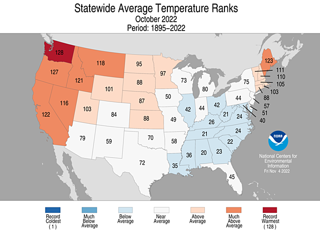
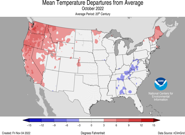
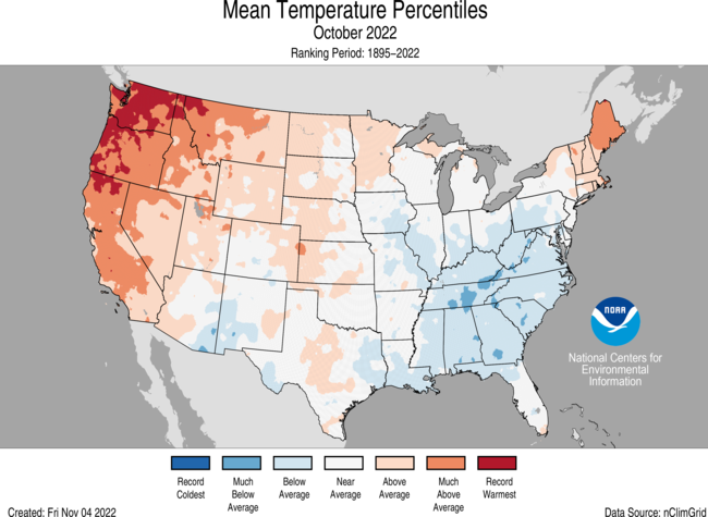
- The contiguous U.S. average temperature during October was 55.3°F, 1.2°F above average, ranking in the warmest third of the record.
- Generally, temperatures were above average in New England and from parts of the central and northern Plains to the West Coast.
- For the month of October, Washington ranked warmest on record, Oregon ranked second warmest, Maine sixth warmest and California ranked seventh warmest on record for this period.
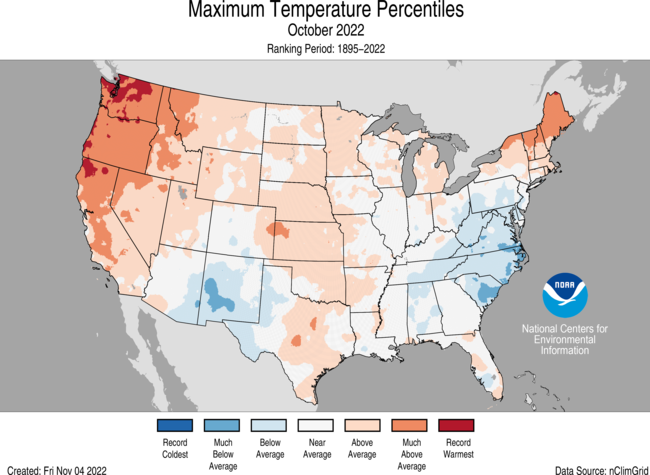
- The contiguous U.S. average maximum (daytime) temperature during October was 68.7°F, 1.9°F above the 20th century average, ranking in the warmest third of the record. Above-average to record-warm maximum temperatures were observed across much of the West Coast, Northeast, and parts of the Great Plains, Upper Midwest and Great Lakes. Washington ranked warmest while Oregon and Maine ranked fourth warmest on record for daytime temperatures. Daytime temperatures were near to or below average across portions of the Southwest, Southeast and Mid-Atlantic region.
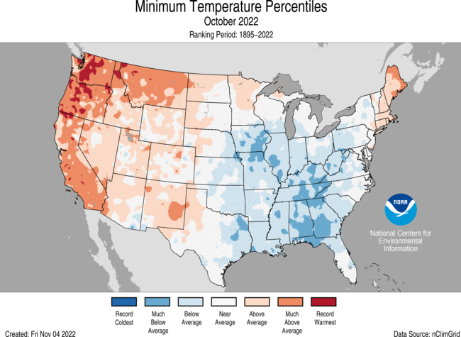
- The contiguous U.S. average minimum (nighttime) temperature during October was 41.9°F, 0.5°F above the 20th century average, ranking in the warmest third of the record. Minimum temperatures were above average to record warm across much of the West and Northeast. Washington, Oregon, California and Montana ranked third through sixth warmest on record, respectively, for October nighttime temperatures. Nighttime temperatures were below-average across much of the Gulf Coast to the Great Lakes. Alabama and Georgia ranked 11th and 12th coldest on record for nighttime temperatures, respectively.
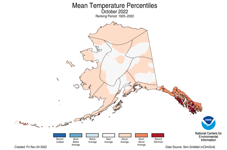
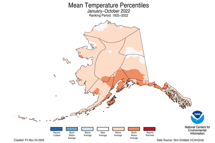
- The Alaska statewide October temperature was 28.8°F, 3.3°F above the long-term average. This ranked in the warmest third of the 98-year period of record for the state. Temperatures were above average across the Panhandle, Aleutians, Yukon Delta, North Slope and parts of the eastern interior while much of the interior experienced near-average conditions for the month.
- Based on data received on November 8, there were 4,728 record warm daily high (2,368) and low (2,360) temperature records tied or broken during October, which is nearly 2.5 times the 2,044 record cold daily high (930) and low (1,114) temperature records.
- Based on NOAA's Residential Energy Demand Temperature Index (REDTI), the contiguous U.S. temperature-related energy demand during October was 80 percent of average and the 43rd-lowest value in the 128-year period of record.
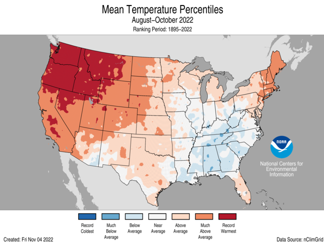
- Temperatures were above average across much of the contiguous U.S. during the August-October period with record warmth blanketing much of the Northwest. Oregon, Washington, Idaho and Montana each had their warmest August-October period on record. The Southeast was cooler than average for this period.
October Precipitation
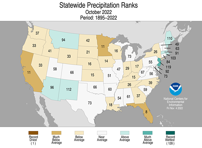
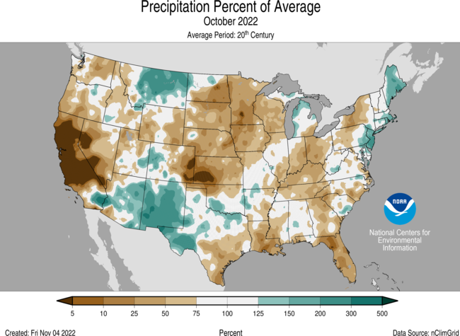
- The October precipitation total for the contiguous U.S. was 1.66 inches, 0.50 inch below average, ranking in the driest third of the historical record.
- Precipitation was above average in Montana and across parts of the Northeast and Southwest and below average across portions of the West, central and northern Plains, Midwest and Southeast.
- Precipitation varied across the contiguous U.S. On the dry side, Florida ranked eighth driest while California and Minnesota each had their 11th-driest October on record. Conversely, the remnants of Hurricane Ian contributed to an abundance of precipitation received during the month, resulting in New Jersey ranking 10th-wettest on record.
- Monthly precipitation averaged across the state of Alaska was 5.57 inches, 1.18 inches above average, ranking as the third-wettest October in the 98-year record. Much of the state was wetter than average, with portions of the Aleutians, southern interior and Kenai Peninsula experiencing near-average conditions during the month.
- According to the November 1 U.S. Drought Monitor, about 62.8 percent of the contiguous United States was in drought, up about 11.9 percent from the end of September. Drought conditions expanded or intensified across much of the Southeast and Mississippi, Ohio and Tennessee valleys, and parts of the Plains, central Rockies, and Northwest. Drought contracted or was eliminated across portions of the Southwest, southern Plains, Northeast and Hawaii.
Other Notable Events
- On November 1, the U.S. Drought Monitor (USDM) revealed nearly 85.3% of the continental U.S. to be abnormally dry or in drought, the largest area affected in the history of the USDM, which launched in 2000.
- The Mississippi River, near Memphis, TN and Vicksburg, MS, was at its lowest water level in a decade, restricting access to a vital channel to barge traffic at a crucial time of the year for transport of crops from the nation’s heartland. Since early October, the U.S. Coast Guard reported a total of eight barges that have run aground. 144 vessels and 2,253 barges were in a queue to access narrow passages of the river.
- On October 1-5, the National Weather Service issued coastal flood alerts along the Mid-Atlantic coast, affecting about 30 million people, as remnants of Hurricane Ian churned off the East Coast. Reports of flooding occurred from the Carolinas to New Jersey.
- On October 16, a historic October heatwave brought summer-like heat, shattering daily high temperature records, across the Pacific Northwest:
- Seattle, WA, broke its previous record high temperature on this day by a staggering 16°F.
- Portland, OR, set record high temperatures on seven days in October and reached at least 80°F on 12 days during the month, doubling the previous October record.
- On October 17-18, an early-season winter storm pounded parts of the Great Lakes bringing record-breaking snowfall totals and knocking out power to tens of thousands of people across the region. Marquette, MI, smashed its record for the largest two-day snow in the month of October with 18.1 inches reported.
- On October 20, Portland, OR, and Seattle, WA, ranked first and second, respectively, for the worst air quality among the world’s major cities, according to IQAIR, as smoke from a string of wildfires darkened skies across parts of the Pacific Northwest.
- A storm moving through the western United States brought cold air and the first substantial snow of the season to many areas between October 22-24:
- In Montana, snowfall in the mountains exceeded one foot in many locations. The highest storm total came from West Yellowstone with a measurement of 29 inches of snow.
- In Utah, Utah Highway Patrol responded to well over one hundred traffic accidents following the winter storm that brought heavy wind, rain, ice and snow to the state. Large snowfall amounts were reported at higher elevations. According to the National Weather Service’s Salt Lake City office, Alta received 25 inches of snow during this period which is more than the average for the entire month (24.4 inches).
- In Colorado, the snowstorm covered the mountains with 10-16 inches of snow in the higher elevations. The snow was preceded by a gusty front that exceeded 60 mph in several locations. Wolf Creek Pass in Mineral, Colorado reported gusts up to 90 mph.
- On October 28, the Hawaii County Civil Defense Agency issued a volcano advisory alert after 36 small earthquakes were detected between October 27 and 28 near Mauna Loa, earth’s largest active volcano. The volcano's heightened state of unrest, with increased earthquake rates, started in mid-September 2022.
- On October 29, at least five tornadoes were confirmed after a severe weather outbreak along the Mississippi and Alabama Gulf Coast. The National Weather Service confirmed that three tornadoes touched down in Jackson County, MS, each with top winds estimated between 100-110 mph, and two other weaker tornadoes were confirmed in Alabama.
Year-to-Date Highlights
January-October Temperature
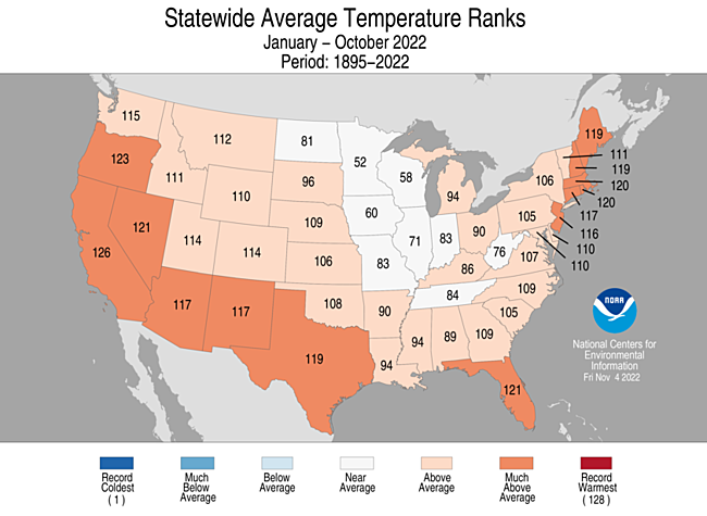
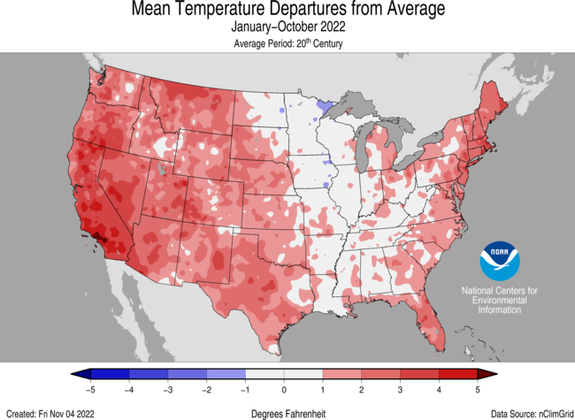
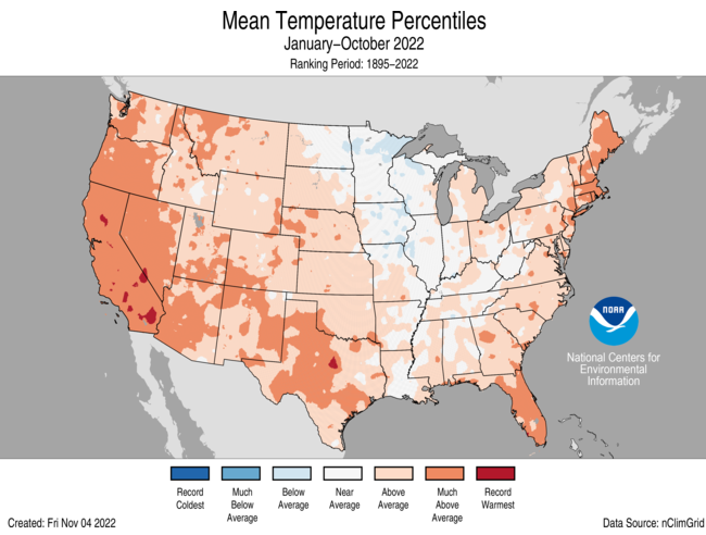
- For the January-October period, the average contiguous U.S. temperature was 56.7°F, 1.7°F above average, ranking 13th warmest in the 128-year record. Temperatures were above average from the West Coast to the Gulf Coast and from the Gulf to New England. California ranked third warmest while Oregon ranked sixth warmest on record for this period. Temperatures were near average from the Mississippi Delta to the Upper Midwest.
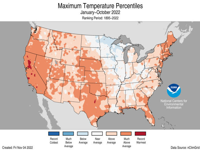
- The contiguous U.S. average maximum (daytime) temperature during January-October was 69.3°F, 2.0°F above the 20th century average, ranking seventh warmest in the historical record. Temperatures were above average across most of the Lower 48 with the exception of portions of the Upper Midwest. California ranked third warmest while Texas, Florida and Massachusetts each ranked seventh warmest for daytime temperatures during January-October.
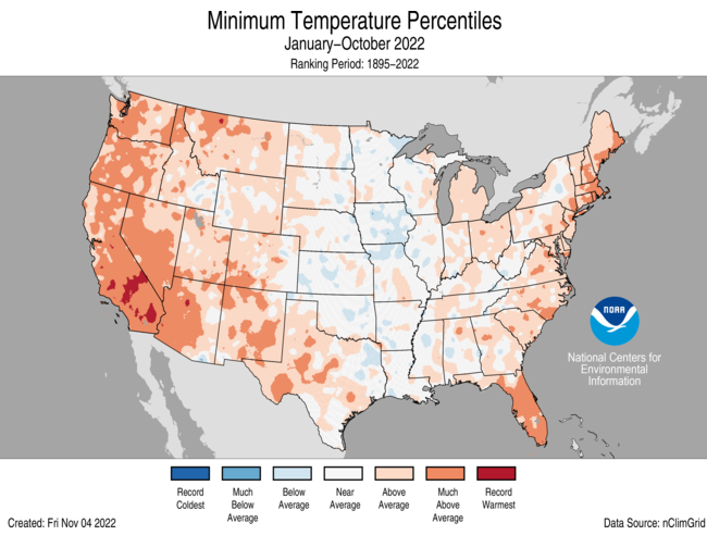
- The contiguous U.S. average minimum (nighttime) temperature during this 10-month period was 44.0°F, 1.3°F above the 20th century average, ranking in the warmest third of the record. Nighttime temperatures were above average across much of the West, southern Plains and eastern U.S. California ranked third warmest on record for nighttime temperatures. Oregon, Nevada, Arizona, Rhode Island and Massachusetts each ranked ninth warmest for this period. Nighttime temperatures were near to or below average across portions of the central U.S.
- The Alaska January-October temperature was 32.2°F, 2.5°F above the long-term average, ranking in the warmest third of the record for the state. Above-average temperatures were observed across much of the state with small portions of the North Slope and eastern interior regions experiencing near-average conditions for this 10-month period.
- Based on REDTI, the contiguous U.S. temperature-related energy demand during January-October was 109 percent of average and was the 54th-highest value on record.
January-October Precipitation
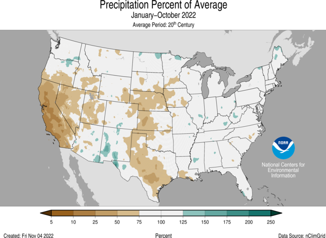
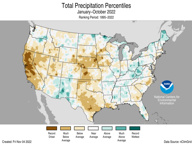
- The January-October precipitation total for the contiguous U.S. was 23.19 inches, 2.17 inches below average, ranking 15th driest in the historical record.
- Precipitation was above average across portions of the Southwest, Mississippi, Tennessee and Ohio valleys as well as the Northeast.
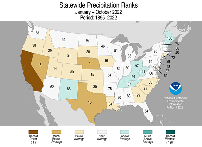
- Precipitation was below average across much of the West, central and southern Plains and parts of the East Coast during the January-October period. California ranked driest on record while Nebraska ranked fourth driest and Nevada eighth driest for this 10-month period.
- The January-October precipitation ranked wettest on record for Alaska, with above-average to record wet precipitation observed across much of the state. The central and Northeast Interior regions as well as the Aleutians experienced near-average precipitation for this period.
Extremes
- The U.S. Climate Extremes Index (USCEI) for the year-to-date period was 25 percent above average and ranked in the highest one-third of the 113-year period of record. Extremes in warm maximum temperatures, warm minimum temperatures, as well as dry PDSI were the major contributors to this elevated CEI value. The USCEI is an index that tracks extremes (occurring in the upper or lower 10 percent of the record) in temperature, precipitation and drought across the contiguous United States.
- On the regional scale, the West, Northern Rockies and Plains, Southwest, Northwest and South ranked above average for this year-to-date period. All of these regions experienced elevated extremes in warm maximum temperatures. The West, Northern Rockies and Plains, Southwest and South also experienced elevated extremes in dry PDSI. Conversely, extremes across the Upper Midwest were 80 percent below average ranking as their fourth lowest season on record.
Monthly Outlook
- According to the October 31 One-Month Outlook from the Climate Prediction Center, areas from the Southwest to the Northeast and across western and northern Alaska are most likely to see above-normal monthly mean temperatures in November, with the greatest odds in New England. The best chances for below-normal temperatures are forecast for southeast Alaska, the Pacific Northwest and the northern Rockies. Much of the West, portions of the central Plains as well as northwestern Alaska are favored to see above-normal monthly total precipitation, with the greatest chance near the northern Rockies. Below-normal precipitation is most likely to occur from south Texas to the Gulf of Mexico and the eastern third of the U.S. Drought is likely to persist across much of the West, Plains, and Mississippi and Ohio valleys. Some improvement and/or drought removal is likely across portions of the central and southern Plains, Northwest and Hawaii. Drought development is likely across portions of the Southeast.
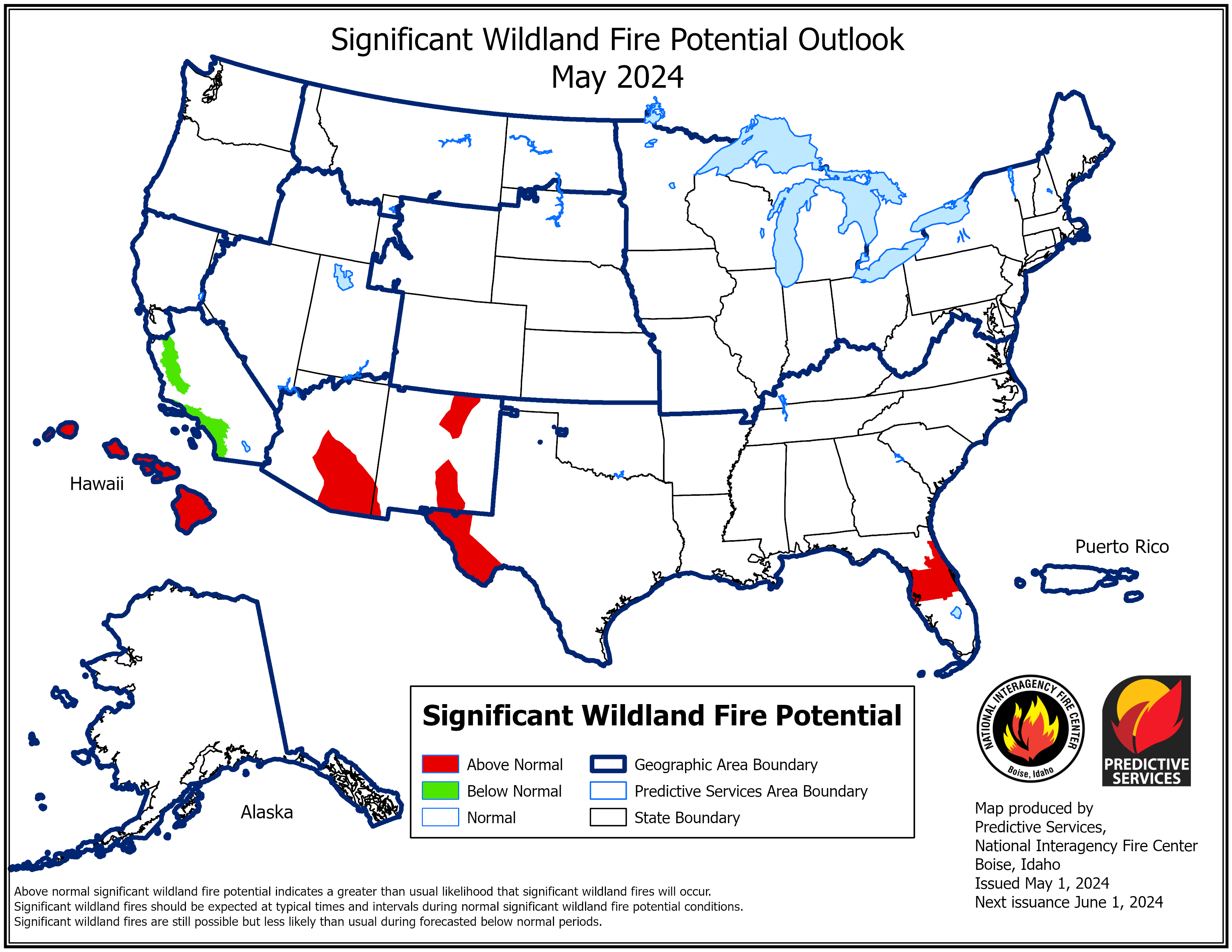
- According to the One-Month Outlook issued on November 1 from the National Interagency Fire Center, Hawaii and portions of the southern Plains, Midwest, Gulf states, and Mississippi, Ohio and Tennessee valleys have above normal significant wildland fire potential during November.
Regional Highlights
These regional summaries were provided by the six Regional Climate Centers and reflect conditions in their respective regions. These six regions differ spatially from the nine climatic regions of the National Centers for Environmental Information.
Northeast Region (Information provided by the Northeast Regional Climate Center)
While state temperatures and precipitation for October spanned the spectrum, the Northeast as a region tilted slightly warmer and drier than normal.
- Temperature
The Northeast’s average temperature for October was 50.5 degrees F, 0.3 degrees F warmer than normal. October average temperatures for the 12 Northeast states ranged from 3.5 degrees F below normal in West Virginia to 4.6 degrees F above normal in Maine, with seven states landing on the warm side of normal for the month. In fact, this October ranked among the 20 warmest Octobers since 1895 for five states: Maine, fourth warmest; Rhode Island and Vermont, 15th warmest; New Hampshire, 16th warmest; and Massachusetts, 17th warmest.
- Precipitation
October precipitation for the Northeast totaled 3.51 inches, which was 84 percent of normal. State precipitation amounts ranged from 54 percent of normal in New York to 154 percent of normal in New Jersey, with eight of the states receiving below-normal precipitation. Despite more states being drier than normal, this October ranked among the 20 wettest Octobers since recordkeeping began for New Jersey, 10th wettest, and Maine, 19th wettest.
- Drought
The U.S. Drought Monitor from October 4 showed less than 1 percent of the Northeast in extreme drought, 3 percent in severe drought, 7 percent in moderate drought, and 16 percent as abnormally dry. During October, coastal areas tended to see above-normal precipitation, allowing drought and abnormal dryness to ease or shrink in coverage in those areas. For instance, extreme drought eased in northeastern Massachusetts, while severe drought was erased in Connecticut and New Jersey. Maine and Rhode Island went from moderate drought in early October to being free of any drought and dryness in late October. However, some interior portions of the Northeast such as central/northern New York and southwestern West Virginia were quite dry during October, causing abnormal dryness to expand or be introduced. The U.S. Drought Monitor from November 1 showed less than 1 percent of the Northeast in severe drought, 2 percent in moderate drought, and 19 percent as abnormally dry. Impacts of the drought conditions continued to trickle in during October. In early October, several waterways in Rhode Island could not be stocked with fish due to drought-induced low water levels or harmful algal blooms. Above-normal rainfall during the rest of October in New England, southeastern New York, eastern Pennsylvania, and New Jersey generally allowed streamflow to improve; however, groundwater and reservoir levels did not fully recover in some areas, causing water restrictions to continue. For example, as of October 27, 100 New Hampshire water systems and four municipalities had water restrictions in place, with most being mandatory. Summer water rates remained in effect for a month longer than usual in Ipswich, Massachusetts. Some New Hampshire and Vermont communities began exploring ways to bolster their groundwater supplies in preparation for future droughts. Drought conditions on Long Island, New York, led to fewer crop diseases, meaning higher quality and yields of irrigated crops; however, irrigation was costly, with one grower raising prices by 15 percent to account for some of those costs. Some Rhode Island growers noted their apples were smaller but more flavorful. October rainfall helped brighten fall foliage and extend the foliage season in parts of Rhode Island.
- Notable Weather
A few storms brought heavy rainfall to the Northeast during October. From October 1 to 5, the remnants of Hurricane Ian traversed the Mid-Atlantic, phased with a coastal low, and stalled off the Mid-Atlantic coast. The storm brought multiple days of rain, gusty winds, and elevated water levels to an area stretching from Maryland to southeastern New York. Storm total rainfall ranged from 2 to 6 inches in many locations, with the greatest totals of 6 to 10 inches generally in parts of Delaware and coastal New Jersey. Atlantic City, New Jersey, set back-to-back daily precipitation records on October 2 and 3, with 3.01 inches of rain on October 2 becoming the site’s fourth wettest October day on record. By five days into the month, Atlantic City had seen 5.88 inches of rain, already qualifying October as the site’s 11th wettest on record. Southern New England and West Virginia also saw some rainfall from the storm system, generally 3 inches or less. The multi-day rainfall event chipped away at drought and abnormally dry conditions from Maryland to Massachusetts. Coastal areas also experienced gusty winds, with the highest gusts ranging from 50 to 70 mph in New Jersey, which contributed to minor to moderate coastal flooding. A slow-moving storm system fueled by moisture from the Atlantic Ocean brought rainfall to the Northeast, particularly New England, from October 13 to 15. The greatest rainfall totals of up to 6 inches were generally reported in Maine where flash flooding led to road closures, caused two roads to collapse, and stranded several vehicles. Gusty winds of up to 58 mph in Massachusetts and Maine downed trees and powerlines, which blocked roads and caused over 100,000 customers in Maine to lose power.
Midwest Region (Information provided by the Midwest Regional Climate Center)
- Temperature
The average Midwest temperature during October was 50.8 degrees F (10.4 degrees C), which was 0.6 degrees F (0.4 degrees C) below the 1991-2020 normal. Temperatures were generally above normal in the northwest and below normal in the southeast. Preliminary statewide average temperatures ranged from 1.6 degrees F (0.9 degrees C) above normal in Minnesota to 3.2 degrees F (1.8 degrees C) below normal in Kentucky. Temperatures swung dramatically mid-month from unseasonably cold to unseasonably warm. Overnight lows dipped into the teens across Minnesota and Iowa, and into the 20s across Missouri, on October 18 and 19. Regionwide, 324 daily low maximum and minimum temperature records were broken or tied across those two days. Conversely, daytime high temperatures from October 22-23 exceeded 80 degrees F (26 degrees C) from Missouri northward into Minnesota. Regionwide, 362 daily high maximum and minimum temperature records were broken or tied from October 22-25.
- Precipitation
October precipitation totaled 1.77 inches (45 mm) for the Midwest, which was 1.33 inches (34 mm) below normal, or 57 percent of normal. Preliminary estimates rank October 2022 as the 11th driest for the Midwest since 1895. All nine states were drier-than-normal, ranging from 0.34 inches (9 mm) below normal in Michigan to 2.15 inches (55 mm) below normal in Kentucky. Only a narrow corridor from Missouri to Michigan measured near- or above-average precipitation. The season’s first accumulating snow was measured in mid-October across the upper Midwest. Locations across northern Minnesota and northern Wisconsin measured about 0.5 inches to 5 inches (1-13 mm) of snow. Across Michigan’s Upper Peninsula, snow totals for October reached 10-15 inches (25-38 mm). Lake-induced snow blanked portions of Indiana and Ohio with 0.1-3 inches (0.3-7 mm) of snow.
- Drought
Drought conditions intensified throughout October, with over 80 percent of the Midwest abnormally dry or in drought by month’s end. Conditions deteriorated rapidly across the lower reaches of the Mississippi River and throughout the Ohio River Valley. Mississippi River levels neared historic lows at Cairo, Illinois and New Marid, Missouri, severely affecting navigation. Ongoing and intensified drought throughout Iowa resulted in widespread burn bans and reduced hydropower production. Topsoil moisture was rated short to very short on 58-80 percent of land across the lower Midwest, excluding Illinois, which ended the month with soaking rain that helped improve soil moisture conditions compared to neighboring states.
- Agricultre
Corn harvest was near or ahead of average for most of the Midwest. Statewide corn yields were within five percent of last year’s yields, except in Kentucky, where yields were down 22 percent, and in Minnesota, where yields were up 7 percent. Soybean harvest was ahead of schedule across the region. Soybean yields were 1.5 percent to 9.8 percent below last year’s, except in Minnesota, where yields were 6.4 percent above. Winter wheat emergence was significantly slowed across the region due to drought.
- For further details on the weather and climate events in the Midwest, see the weekly and monthly reports at the Midwest Climate Watch page.
Southeast Region (Information provided by the Southeast Regional Climate Center)
- Temperature
Monthly temperatures were below average across the Southeast in October. Most locations were 2 to 4 degrees F (1.1 to 2.2 degrees C) below average, with some locations between 5 and 6 degrees F (2.8 and 3.4 degrees C) below average. Much of the Florida Peninsula was 1 to 2 degrees F (0.5 to 1.1 degrees C) below average. In contrast, monthly temperatures were near average to slightly above average across Puerto Rico and the U.S. Virgin Islands. October began with unseasonably cool maximum temperatures across coastal sections of the Carolinas and Virginia in the wake of Hurricane Ian. Many locations were 10 to 20 degrees F (5.6 to 11.1 degrees C) below average. Washington D.C. and Norfolk, VA set daily low maximum temperature records of 55 degrees F (12.8 degrees C) and 54 degrees F (12.2 degrees C), respectively, on the 4th of the month. A brief period of unseasonably warm weather occurred in the middle of the month, with maximum temperatures ranging from 5 to 10 degrees F (2.8 to 5.6 degrees C) above average across much of the region from the 15th to the 17th. The first widespread freeze of the season occurred between the 18th and 20th of the month, which was 1 to 2 weeks earlier than normal for many locations. Birmingham, AL recorded its second earliest freeze on record (since 1896), missing the record by just one day. Tallahassee, FL missed its earliest freeze on record (since 1900) by just two days. Mean temperatures during this 3-day stretch ranged from 10 to over 20 degrees F (5.6 to 11.1 degrees C) below average across a large portion of the region. October ended with unseasonably warm weather across much of the Southeast, with maximum temperatures between 5 and 10 degrees F (2.8 and 5.6 degrees C) above average across the eastern and southern portions of the region. Fort Myers, FL tied it warmest Halloween on record (since 1904) with a temperature of 91 degrees F (32.8 degrees C) on the 31st of the month.
- Precipitation
Monthly precipitation totals were below average across the Southeast in October. The driest locations were found across the northern half of Florida, where some places received less than half of an inch (12.7 mm) of precipitation for the month (less than 25 percent of normal). Daytona Beach, FL recorded just 0.36 inches (9.1 mm) of precipitation, which is nearly 4.5 inches (114 mm) below average. Gainesville, FL recorded only 0.16 inches (4.1 mm) for the month, while Ocala, FL recorded just 0.04 inches (1 mm) of precipitation, which is the fourth driest October on record (since 1902). While Tallahassee, FL ended a streak of 30 consecutive days without measurable precipitation on the 11th, they recorded just 0.22 inches (5.6 mm) for the month. Dry conditions were also noteworthy across northern sections of Georgia and South Carolina, where monthly precipitation totals were between 50 and 25 percent of normal, as well as across coastal sections of Georgia and the Carolinas, where several locations recorded less than 1 inch (25 mm) of precipitation. Wilmington, NC recorded just 0.59 inches (14.9 mm) in October, which is over 4 inches (102 mm) below average. Savannah, GA, Charleston, SC, Myrtle Beach, SC, Florence, SC, and New Bern, NC also recorded less than 1 inch (25 mm) of precipitation for the month, which is 3 to 4 inches (76 to 102 mm) below average. Trace amounts of snow were recorded for the first time this season across the higher elevations of North Carolina and Virginia on the 19th of the month. Precipitation in October was above average across Puerto Rico, with monthly departures of 5 to 10 inches (127 to 254 mm) across the western part of the island and 1 to 5 inches (25 to 127 mm) across the eastern half of the island. Monthly precipitation totals were variable across the U.S. Virgin Islands. An upper-level trough and associated tropical wave contributed to heavy rain and flooding across the region from the 26th to the 28th of the month. Many places recorded between 3 and 8 inches (76 and 203 mm) of precipitation during this event. In addition, Washington D.C. recorded six consecutive days of measurable precipitation ending on the 5th of the month, which is just two days shy of the longest run of consecutive days of measurable precipitation in a record going back to 1872.
- Drought
For the second straight month, drought conditions worsened across the Southeast, particularly across northwest Florida, southern Alabama, and northern Georgia, where severe drought (D2) emerged by the end of October. Moderate drought (D1) also expanded in these areas, as well as across central and northern portions of Alabama and Georgia, the Upstate of South Carolina, and western North Carolina. Abnormally dry (D0) conditions also expanded in these areas and emerged across central and eastern sections of North Carolina. There were a few improvements in isolated parts of Alabama that did receive higher precipitation amounts. By the end October, over half of the region was under some drought designation, while over 20 percent of the region was in either moderate or severe drought. Abnormally dry conditions expanded slightly across Puerto Rico and the U.S. Virgin Islands, though most of the region remains drought-free.
- Agricultre
The cool and dry weather in October helped with the harvest of many crops, particularly across parts of Alabama, Georgia, and South Carolina, though yields were generally below average. These included cotton, soybeans, peanuts, and pecans. Planting of winter wheat and small grains also progressed well with some emergence by the end of the month. Cattle and livestock were in generally good condition due to the cooler temperatures across the region. Planting and harvest of fruits, vegetables, sugarcane, and rice picked up again across parts of Florida following Hurricane Ian, though some river pastures remain flooded. Grove operations also progressed well with some irrigation use during the month. However, the short-term dryness has resulted in poor pasture and forage quality for livestock, particularly across northern Florida where some farms went over a month without any precipitation. Low soil moisture also created difficulty for peanut harvesting and the planting of small grains and winter wheat. In addition, the cooler temperatures resulted in fewer heat units and some frost damage on late-planted crops, which may reduce yields. Frost damage was also reported on unopened cotton bolls in parts of northern and central Georgia. The remnants of Hurricane Ian dropped between 1 and 3 inches (25 and 76 mm) of rain across parts of Virginia at the beginning of the month, which benefited many drought-stressed crops, particularly hay and pasture. On the other hand, heavy rain across Puerto Rico created many challenges for farmers and slowed clean-up and recovery efforts following Hurricane Fiona. In contrast, water conservation efforts have begun across the U.S. Virgin Islands in preparation for the dry season. Agriculture and vegetation are improving in areas that have been impacted by high winds and rain from recent storms, though there is uncertainty about yields and the financial cost of replanting damaged crops.
- Notable Weather
There were 41 reports of severe weather across the Southeast in October, which is slightly below the median monthly frequency of 44 reports over the period 2000 to 2010. There were 8 confirmed tornadoes, which is also below the median frequency of 10. On the 17th of the month, an EF-0 tornado touched down in a mobile home community in Vero Beach, FL, resulting in minor damage to trees and structures. Another EF-0 tornado touched down and caused mostly minor damage in Holmes County in northwest Florida on the 25th of the month. The remaining tornadoes occurred across coastal Alabama on the 29th of the month. Three EF-1 tornadoes touched down in the communities of Magnolia Springs, Bon Secour, and Spanish Fort in Baldwin County. The most severe damage included uprooted trees and snapped power lines. Three people were injured in a mobile home that rolled on its side in Bon Secour. Another EF-0 tornado was reported in the community of Point Clear and resulted in mostly minor damage to some trees and structures. Two tornadoes were reported in Mobile County. The strongest was an EF-1 tornado that touched down in the community of Dawes, resulting in significant damage to trees and some structures, including one home where the windows were blown out. The other tornado was rated EF-0 and caused mostly minor damage to trees and structures in the community of Orchard. There were 15 wind reports in October, which is less than half of the median monthly frequency. On the 17th of the month, strong thunderstorm winds brought down trees and power lines near the community of Barranquitas in the interior of Puerto Rico. One injury was reported. Heavy rain on the 8th of the month resulted in significant flooding near Santo Domingo on the southern end of the island. At least four people were rescued from the flood waters, while two people remain missing. Two days later, heavy rain resulted in flooded roads and homes near San Juan. At least one person was injured, and one person had to be rescued from their car after it became trapped in the flood waters. There were 13 reports of hail in October. The largest hailstone recorded was 2 inches (50.8 mm) near the town of Gallion in Hale County, AL on the 12th of the month.
- 2022 Atlantic Hurricane Season
The Atlantic basin saw three named storms in October (Hurricane Julia, Tropical Storm Karl, and Hurricane Lisa). However, none of these storms affected the Southeast region.
- For more information, please visit the Southeast Regional Climate Center Home Page.
High Plains Region (Information provided by the High Plains Regional Climate Center)
October was a month with flavor of every season, with everything from severe storms to heavy snow across the region. Drought-stricken Kansas was nearly bone-dry, while western Colorado observed above-normal precipitation and up to 22 inches (56 cm) of snow in some places. Temperatures were above normal for much of the region throughout the month. A vigorous low-pressure system trekked across the region on the 23rd, causing numerous impacts in multiple states. Severe storms impacted northeastern Nebraska and southeastern South Dakota, with 2-inch hail and 70 miles per hour (113 km/h) winds reported. Simultaneously, snow fell in western parts of the Dakotas and Wyoming. High winds also wreaked havoc in the southern part of the region. With ample fuel available, these winds sparked several large fires in Kansas and Nebraska. Several towns were evacuated in Nebraska due to the danger, with a large fire raging just south of Lincoln. The western parts of both states also experienced large amounts of blowing dust. The winds, unfortunately, led to two deaths in Colorado after their kayak flipped over due to the high waves.
- Temperature
Overall, October was unusually warm throughout the region. Much of the region was above normal, with places up to 6 degrees F (3.3 C) above their normal temperature. An unseasonably warm period impacted the region on October 21-23. Many locations set daily records, with some places reaching their warmest temperature on record through the end of the year. A total of 232 daily temperature records were broken during this period throughout the region. In Nebraska, Lincoln and Grand Island tied their warmest temperature on record for this late in the year. Another notable statistic about this heat wave is the number of 80 degrees (26.7 degrees C) plus days that Lincoln has observed this year. A whopping 142 days this year have reached that temperature, which is the most on record. Further south in Kansas, Russell reached 93 degrees F (33.9 degrees C) on the 23rd, surpassing their previous warmest temperature for the rest of the year by 4 degrees F (2.2 degrees C).
- Precipitation
The region was extremely dry this past month, with large portions receiving less than 0.10 inches (2.54 mm) of precipitation. The western parts of Colorado and North Dakota received above-normal precipitation, however, the drought-afflicted areas in the region were bone dry. Precipitation has been very hard to come by in southwestern Kansas this year, and October did no favors. Dodge City tied their driest month on record, with only trace precipitation. Through the end of October, Dodge City is nearly 9 inches below its normal precipitation. Many locations across Kansas and Nebraska currently rank in the top 10 driest through the end of October. Norfolk, Nebraska, recorded its driest January-October, with this year being over 0.50 inches (12.70 mm) drier than in 2012. In South Dakota, Aberdeen recorded back-to-back top 10 driest months. Only 0.21 inches (5.34 mm) of precipitation has occurred, ranking 2nd driest for September-October. The lack of precipitation and warmer temperatures have led to a rapid expansion of drought conditions in that part of the state.
- Drought
Drought conditions rapidly expanded this past month, with nearly 76 percent of the region experiencing moderate to exceptional (D1-D4) conditions. The Dakotas observed the largest increases in drought coverage, with both states increasing by over 20 percent. As the year is nearly over, Kansas and Nebraska are in rough shape heading toward winter. In just October alone, Nebraska experienced a 21 percent increase in extreme drought (D3), and Kansas recorded nearly a 13 percent increase in exceptional drought (D4). Both states are in large precipitation deficits and will likely not see much improvement over the winter. In the meantime, not only did drought rapidly expanded in the Dakotas, but it also intensified quickly, with both states recording a 25 percent increase in severe drought (D2). Elsewhere in the region, other improvements and degradation were observed.
- For more information, please visit the High Plains Regional Climate Center Home Page.
Southern Region (Information provided by the Southern Regional Climate Center)
Continued dry weather across the central United States led to record low water levels along the lower Mississippi River, snarling barge traffic.
- Temperature
October 2022 was cool toward the east and near normal toward the west. Tennessee was 21st coldest on record (out of 128 years) with an average temperature of 56.3 F, 3.0 F below normal but 4.1 F above the record low value set in October 1917. Louisiana and Mississippi ranked 36th and 37th coldest, respectively. Arkansas, Texas, Oklahoma, and the region as a whole were all close to their historical median value, running slightly cooler than normal for the most part. Five stations topped out at exactly 100 F, all in Texas: Waco on October 12, Santa Ana National Wildlife Refuge on October 13, Falcon Dam and Falcon Lake on October 14, and Rio Grande Village on October 23. The lowest temperature recorded was at Mt Leconte, Tennessee, which reached 12 F on multiple days. The lowest temperature at a lower-altitude station was 18 F in Bartlesville, Oklahoma, on October 19. One long-term station set an all-time October record: Homer, Louisiana, whose minimum temperature was 25 F on October 19.
- Precipitation
Precipitation was below normal for every state in the Southern Region. The region-wide average was 2.35 inches, about an inch below normal and ranking 53rd driest overall. The largest statewide average was in Arkansas, but its 3.17 inches was still 1.14 inches below normal. Driest of all was Louisiana, which averaged only 1.33 inches for the month, 3.14 inches below normal and 19th driest on record. A total of seven stations (six in Texas and one in Louisiana) reported no measurable precipitation for the month. The six wettest stations were in Texas, including one airport (Paris, at 7.64 inches) and five CoCoRaHS stations: Ravenna (8.72), Van Alstyne (8.22), Paris (8.20), Powderly (7.83), and Dodd City (7.77). Marietta Oklahoma reported 7.59 inches, while Big Fork Arkansas reported 7.51 inches. Tennessee did not have a station report at least five inches of precipitation. The largest single-day totals were 4.92 inches near Port Arthur, Texas, on October 29 and 4.62 inches at Siloam Springs, Arkansas on October 25.
- Drought/Flooding
During October, drought conditions generally improved in West and North Texas, southern Oklahoma, and western Arkansas. Conversely, degradations were common in southern and southeastern Texas, Louisiana, Tennessee, Mississippi, and the remainder of Arkansas. By October 25, portions of all six states were in at least Severe Drought according to the US Drought Monitor. Drought conditions in the Southern Region and elsewhere led to record low water levels along the Mississippi River. October is typically the time of lowest flows, but the dry late summer led to this fall being exceptional. The gauge at Memphis, Tennessee, bottomed out at -10.81 feet, about a foot below the previous record and corresponding to a flow of 147,000 cubic feet per second. As recently as September 11, the river was 20 feet higher with more than double the flow. By November 1, the situation was only slightly better, with a height of -8.16 feet and a flow of 181,000 cubic feet per second. According to the USDA, spot prices for shipping one ton from St. Louis rose from less than $20 in early September to over $70 during most of October. With low river flows, denser salt water began penetrating inland beneath the surface of the Mississippi River, causing elevated sodium levels in some drinking water supplies in Louisiana.
- Notable Weather
There were six tornadoes during October in the Southern Region, including an EF1 tornado that caused one injury near Jarrell, Texas, on October 25. The strongest was an EF2 near Oberlin, Louisiana, the same day, while three EF1 tornadoes were confirmed near Moss Point in southeast Mississippi on October 29. The largest of the 69 hail reports was 3-inch diameter hail late on October 15 in the town of Olyphant in northeastern Arkansas. Among the 87 wind reports was a thirty-mile-long downburst south of Memphis in Tennessee that caused one fatality when a tree fell on a motorist. The region continued to avoid tropical cyclone landfalls.
- For more information, please visit the Southern Regional Climate Center Home Page.
Western Region (Information provided by the Western Region Climate Center)
October 2022 featured dry and warm conditions across much of the western U.S. Numerous stations in the Pacific Northwest experienced a top 5 hottest October while locations in the Desert Southwest experienced colder than normal conditions. Dry conditions persisted everywhere but Arizona, New Mexico, and central Montana as anomalous high pressure remained centered over western North America but moisture and weak low pressure systems were able to undercut this ridge and bring precipitation into the Desert Southwest. Facilitated by notably dry and warm conditions with numerous active wildfires, a week-long heat wave and poor air quality (a “smoke wave”) impacted population centers in the Pacific Northwest.
- Temperature
Temperatures were well above normal (2-6 degrees Fahrenheit) across the West with the exception of the Desert Southwest, where temperatures were 0-4 degrees Fahrenheit below normal. The coldest anomalies occurred in far southern Arizona and New Mexico. Hot anomalies on the order of 8-10 (or more) degrees Fahrenheit occurred in northern central Montana, throughout Washington, and in scattered areas of central and western Oregon and the Sierra Nevada of California. This was the warmest October on record at cities including Portland, Pendleton, and Medford, in Oregon as well as Missoula, Montana. Seattle, Washington averaged 57.6 degrees Fahrenheit (14.2 degrees Celsius), 4 degrees Fahrenheit (2.2 degrees Celsius) above normal and the second warmest October in 75 years. With a mean temperature of 61.4 degrees Fahrenheit (16.3 degrees Celsius), 6 degrees Fahrenheit (3.3 degrees Celsius) above normal, Portland, Oregon observed its hottest October in 82 years of record keeping. Hereford, Arizona observed a mean temperature of 59.6 degrees Fahrenheit, which is 4 degrees Fahrenheit (2.2 degrees Celsius) below normal, its sixth coldest in 57 years.
- Precipitation
Precipitation was well-below normal throughout California as well as western and southern Nevada, with many stations recording zero precipitation. Dry conditions were also widespread in Washington. Central Montana observed above normal precipitation, with Holter Dam measuring 2.84 inches (72 millimeters) of rainfall, which is 1.8 inches above normal (273 percent of normal), tying its fourth wettest October in 118 years. The Desert Southwest saw well-above normal precipitation with the greatest positive anomalies in the southern and central regions.
- Drought
Approximately 95 percent of the western U.S. remains in drought with nearly 20 percent in extreme (D3) to exceptional (D4) drought. Drought is most widespread and severe in California, Oregon, Nevada, northern Montana, and eastern New Mexico.
- Alaska Summary
October brought active weather to Alaska, with widespread above normal temperatures, especially in Southeastern Alaska. Sitka set an all-time October high temperature of 70 degrees Fahrenheit (21.1 degrees Celsius). Petersburg reached 69 degrees Fahrenheit (20.5 degrees Celsius) on October 16, which may be the highest reliable temperature this late in the season in Alaska since 1938. Precipitation was near to above normal. Sea ice began its seasonal increase in the Beaufort and Chukchi Seas, however it remained below historical (satellite-record) levels. Sea ice in the Bering Sea began to form late in the month in major river deltas and wave-protected bays.
- Hawaii Summary
Drought conditions remain widespread across the Hawaiian Islands, compared to three months ago, some minor improvements occurred. The U.S. Drought Monitor has 82 percent of the state experiencing abnormally dry (D0) to exceptional (D4) drought conditions. Nearly 25 percent of Hawaii is in severe (D2) to exceptional (D4) drought. Honolulu received 0.79 inches (20 millimeters) of rainfall, which is 0.72 inches (18 millimeters) below normal (52% of normal).
- Significant Events for October 2022
Heat and Air Pollution Engulf Pacific Northwest: From October 14-October 21, an amplified ridge of high pressure resulted in well-above average temperatures, with several stations setting October high temperature records. Ongoing drought and hotter and drier than normal weather created favorable fire weather conditions. Numerous wildfires produced plentiful smoke, the dispersion of which was greatly limited by the calm winds and stable atmosphere beneath the ridge. As a result, a period of prolonged hot and polluted air (Air Quality Index values exceeding 400) engulfed many cities in the Pacific Northwest. Impacts from heat and air pollution are difficult to immediately quantify, but it is likely this event will drive an increase in hospitalizations, decrease in general health and well-being (especially among disadvantaged community members), and lowered economic activity in the region.
- For more information, please go to the Western Regional Climate Center Home Page.