National Overview

September Highlights
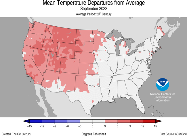
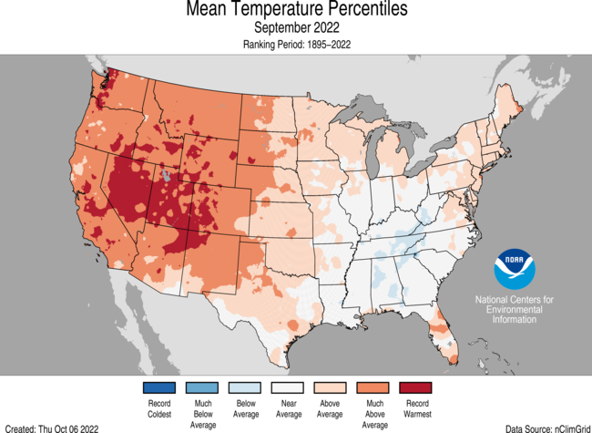
September Temperature
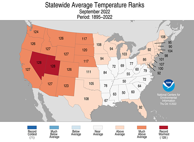
- The contiguous U.S. average temperature during September was 68.1°F, 3.2°F above the 20th century average, ranking fifth warmest in the 128-year record.
- Generally, temperatures were above average in the Great Lakes to Northeast with record warmth across much of the West.
- For the month of September, Nevada and Utah ranked warmest on record. In addition to this record warmth, near-record temperatures were widespread across the West. California, Idaho, Wyoming and Arizona each had their second warmest September, with four additional states experiencing a top-five warmest September on record.
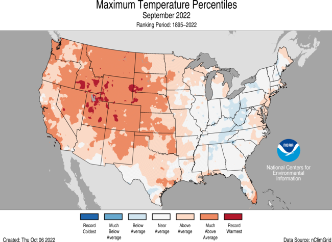
- The contiguous U.S. average maximum (daytime) temperature during September was 81.2°F, 3.4°F above the 20th century average, ranking seventh warmest on record. Above-average to record-warm maximum temperatures were observed across much of the Great Plains to the West Coast and parts of the East Coast. Wyoming ranked warmest on record for daytime temperatures. Daytime temperatures were near to or below average across portions of the Great Lakes, Ohio Valley, Northeast and Southeast.
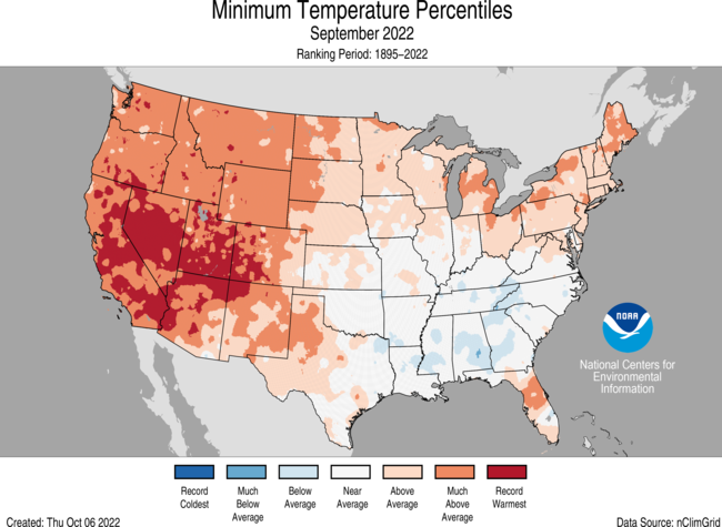
- The contiguous U.S. average minimum (nighttime) temperature during September was 54.9°F, 3.0°F above the 20th century average, ranking sixth warmest on record. Minimum temperatures were above average to record warm across the West, northern Plains, Great Lakes and Northeast. California, Nevada, Utah and Arizona each ranked warmest on record for September nighttime temperatures.
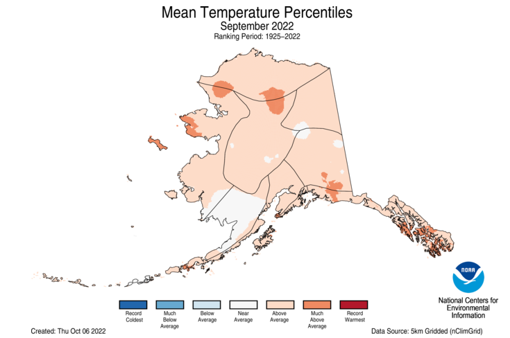
- The Alaska statewide September temperature was 43.0°F, 2.4°F above the long-term average. This ranked in the warmest third of the 98-year period of record for the state. Temperatures were above average across much of the state with portions of southwest Alaska experiencing near-average conditions for the month.
- Based on data received on October 12, there were 9,316 record warm daily high (5,134) and low (4,182) temperature records during September, which is nearly 15 times the 614 record cold daily high (407) and low (207) temperature records.
- Based on NOAA's Residential Energy Demand Temperature Index (REDTI), the contiguous U.S. temperature-related energy demand during September was 127 percent of average and the 35th-highest value in the 128-year period of record.
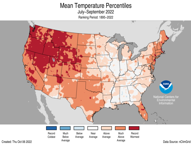
- For the July-September period, the average contiguous U.S. temperature was 73.0°F, 2.8°F above average, ranking as warmest on record for this 3-month period. Temperatures were above average across most of the contiguous U.S. with record warmth blanketing much of the West. California, Nevada, Oregon, Washington, Idaho, Montana, Wyoming, Colorado and Utah each had their warmest July-September period on record. Seven additional states experienced a top-five warmest event for this three-month period.
September Precipitation
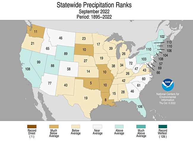
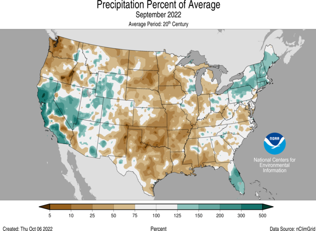
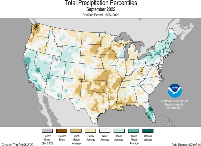
- The September precipitation total for the contiguous U.S. was 1.83 inches, 0.66 inch below average, ranking 10th driest on record.
- Precipitation was above average across the Northeast, Florida, and much of the central Rockies to California. Precipitation was below average across the Pacific Northwest, Plains to Mississippi Valley, Great Lakes and parts of the Southeast.
- Dry conditions across the central U.S. resulted in Oklahoma ranking fifth driest while Mississippi had its eighth-driest September on record. Arkansas, Missouri and South Dakota each had their 10th driest September on record. No state experienced a top-10 wettest September.
- Monthly precipitation averaged across the state of Alaska was 6.76 inches, 2.19 inches above average, ranking as the third-wettest September in the 98-year record. Much of the state was wetter-than-average, with portions of the Aluetians and lower Panhandle experiencing near-average conditions during the month.
- According to the September 27 U.S. Drought Monitor, about 50.9 percent of the contiguous United States was in drought, up about 5.4 percent from the end of August. Drought conditions expanded or intensified across portions of the Mississippi Valley, central and northern Plains, Northwest, Southeast and parts of the Great Lakes. Drought contracted or was eliminated across portions of the Southwest, southern Plains, Northeast and Puerto Rico.
Other Notable Events
- September had several notable storms that brought destruction and flooding to portions of the United States and its territories:
- On September 9, Tropical Storm Kay impacted California with gusty winds and heavy rains causing mudslides.
- The powerful remnants of Typhoon Merbok pounded Alaska’s western coast on September 17, pushing homes off their foundations and tearing apart protective berms as water flooded communities. This was the strongest storm to enter the Bering Sea during September in 70 years.
- On September 18, Hurricane Fiona brought massive flooding to Puerto Rico with some areas receiving 12-18 inches of rain. One station reported 27.14 inches of rain in a 24-hour period.
- Hurricane Ian, with 150 mph sustained winds, made landfall in southwest Florida as a strong Category 4 hurricane on September 28, resulting in major flooding, damage and loss of life.
- On September 30, Ian, with 85 mph sustained winds, created additional damage as it made landfall in South Carolina as a Category 1 hurricane.
- A heatwave settled over the West the first week of September and brought scorching temperatures that set all-time record highs. By September 9, nearly 1,000 heat records were broken.
- On September 4, the Georgia governor declared a state of emergency in Chattooga and Floyd counties after receiving an estimated 12 inches of rain. In Summerville, Georgia, some 8,000 homes and businesses lost access to running water.
- On September 4, torrential rains caused flooding in parts of Indiana and Kentucky. Parts of southern Indiana were drenched by an excess of 9 inches of rain in a three-hour period causing significant flooding and washing away homes.
- As of October 5, there were 57 active wildfires in the Pacific Northwest (Idaho, Montana and Oregon) that burned over 660,000 acres to date across the region.
Billion-Dollar Weather and Climate Disasters
- From January through the end of September, the U.S. experienced 15 weather and climate disasters each incurring losses that exceeded $1 billion. These disasters included: 10 severe storms, two tropical cyclones, one flooding event, one combined drought and heat wave and one regional wildfire event.
- Six new events have been added since the mid-year update including: Hurricanes Ian and Fiona, the Western wildfires, the Kentucky/Missouri flooding and two severe storm events.
- The loss of human life this year from these disaster events exceeds 340 people, with assessments ongoing due to recent hurricane impacts in Florida and Puerto Rico. There were more than 100 lives lost in both Hurricane Ian and from the summer heatwaves in the Western U.S.
- Total loss due to property and infrastructure damage to-date is up to $29.3 billion—but this does not yet include the costs for Hurricane Ian, the Western Wildfires and Hurricane Fiona, which may push the 2022 total closer to $100 billion, a total reached in four of the last five years.
- This is also a record eighth-consecutive year where the U.S. experienced 10 or more billion-dollar disasters.
- The U.S. has sustained 338 weather and climate disasters since 1980 where overall damages/costs reached or exceeded $1 billion (including CPI adjustment to 2022). The total cost of these 338 events exceeds $2.295 trillion.
Year-to-Date Highlights
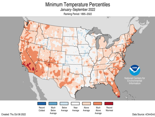
January-September Temperature
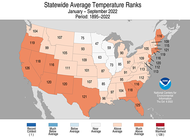
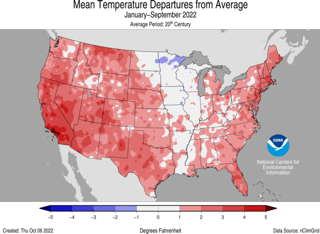
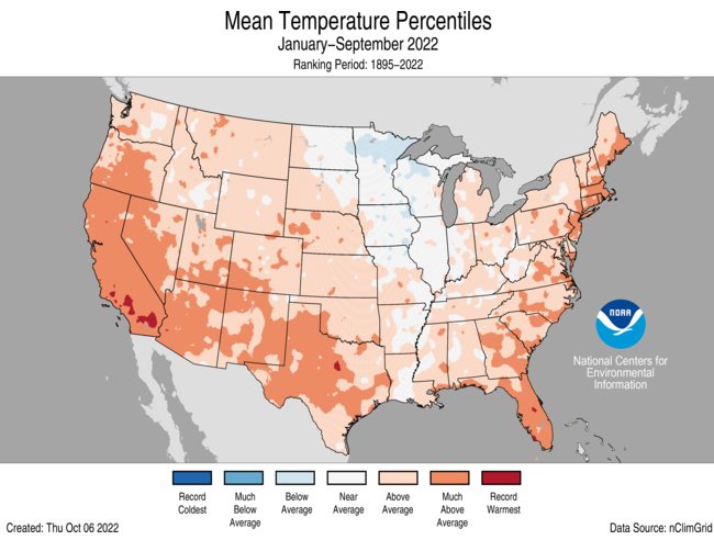
- For the January-September period, the average contiguous U.S. temperature was 56.8°F, 1.7°F above average, ranking in the warmest third of the record. Temperatures were above average from the West Coast to the Gulf Coast and from the Gulf to New England. California ranked third warmest and Florida ranked fourth warmest on record for this period. Temperatures were near average across parts of the Upper Midwest and northern Plains.
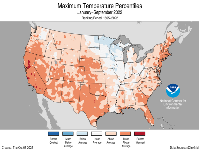
- The contiguous U.S. average maximum (daytime) temperature during January-September was 69.4°F, 2.1°F above the 20th century average, ranking seventh warmest in the historical record. Temperatures were above average across all of the Lower 48 with the exception of portions of the Upper Midwest. California ranked third and Texas ranked fifth warmest for daytime temperatures during January-September.
- The contiguous U.S. average minimum (nighttime) temperature during this nine-month period was 44.3°F, 1.4°F above the 20th century average, ranking in the warmest third of the record. Nighttime temperatures were above average across much of the West, southern Plains and eastern U.S. California ranked fifth and Florida ranked sixth warmest for nighttime temperatures.
- The Alaska January-September temperature was 32.6°F, 2.5°F above the long-term average, ranking in the warmest third of the record for the state. Above-average temperatures were observed across much of the state with portions of the North Slope and eastern interior regions experiencing near-average conditions for this nine-month period.
- Based on REDTI, the contiguous U.S. temperature-related energy demand during January-September was 113 percent of average and was the 48th-highest value on record.
January-September Precipitation
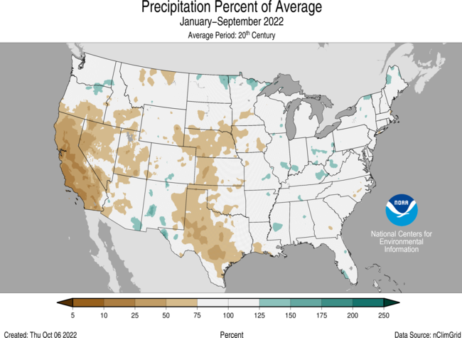
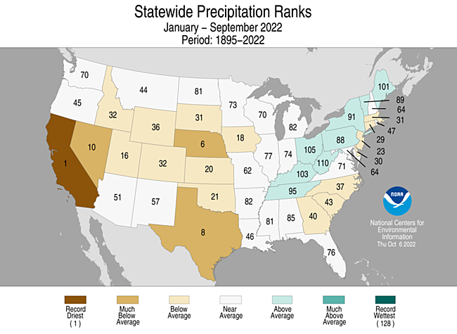
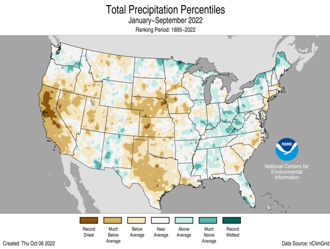
- The January-September precipitation total for the contiguous U.S. was 21.53 inches, 1.67 inches below average, ranking in the driest third of the historical record.
- Precipitation was above average across parts of the Northeast, Appalachian Mountains, Ohio and Tennessee River valleys, lower Mississippi Valley, and parts of the Great Lakes, Southwest and Northwest.
- Precipitation was below average across much of the West, central and southern Plains and parts of the East Coast during the January-September period. California ranked driest on record while Nebraska ranked sixth driest and Texas ranked eighth driest for this nine-month period.
- The January-September precipitation ranked 10th-wettest on record for Alaska, with above average precipitation observed across all but the central and northeast Interior and Aleutian regions.
Extremes
- The U.S. Climate Extremes Index (USCEI) for the year-to-date period was 26 percent above average and ranked in the highest one-third of the 113-year period of record. Extremes in warm maximum temperatures, warm minimum temperatures, as well as dry PDSI were the major contributors to this elevated CEI value. The USCEI is an index that tracks extremes (occurring in the upper or lower 10 percent of the record) in temperature, precipitation and drought across the contiguous United States.
- On the regional scale, the West, Southwest, Northwest, South and Southeast ranked above average for this year-to-date period. Elevated regional extremes were due primarily to large areas of warm maximum temperatures, warm minimum temperatures and dry PDSI. Conversely, extremes across the Upper Midwest were 76 percent below average with virtually no extremes in temperatures or dry PDSI observed.
Monthly Outlook
- According to the September 30 One-Month Outlook from the Climate Prediction Center, much of the contiguous U.S. from Florida to the West Coast, as well as much of Alaska, have the greatest chance of seeing above-normal monthly temperatures in October, whereas the greatest chance for below-normal temperatures is projected to occur across portions of the Mid-Atlantic. Portions of the Southwest, Mid-Atlantic and Alaska are projected to have the greatest chance of above-normal monthly total precipitation, while the greatest chance for below-normal precipitation is favored to occur from the Gulf of Mexico to the northern Plains and into New England. Drought is likely to persist across much of the West, central Plains and Hawaii with some improvement and/or drought removal likely along the Mid-Atlantic coastline. Drought development is likely from the southern Plains to the southern Mississippi Valley, as well as across portions of the central and northern Plains.
- According to the One-Month Outlook issued on October 1 from the National Interagency Fire Center, southwest California, Hawaii and portions of the southern Plains and Mississippi Valley have above normal significant wildland fire potential during October.
Regional Highlights
These regional summaries were provided by the six Regional Climate Centers and reflect conditions in their respective regions. These six regions differ spatially from the nine climatic regions of the National Centers for Environmental Information.
Northeast Region (Information provided by the Northeast Regional Climate Center)
September was warmer and wetter than normal for many parts of the Northeast, helping alleviate drought and dryness in the region.
- Temperature
The Northeast’s average temperature for September was 62.3 degrees F, 0.6 degrees F warmer than normal. September average temperatures for the 12 Northeast states ranged from 0.4 degrees F below normal in West Virginia, the only cooler-than-normal state, to 1.4 degrees F above normal in New Jersey, its 13th warmest September since 1895. In addition, Maine had its 20th warmest September on record.
- Precipitation
During September, the Northeast received 4.58 inches of precipitation, 114 percent of normal. September precipitation for the 12 Northeast states ranged from 69 percent of normal in Maryland to 150 percent of normal in Rhode Island, with eight states wrapping up the month on the wet side of normal. This September was among the 20 wettest Septembers on record for three states: Vermont, 16th wettest; New York, 18th wettest; and New Hampshire, 19th wettest.
- Drought
The U.S. Drought Monitor released on September 1 showed 2 percent of the Northeast in extreme drought, 9 percent in severe drought, 13 percent in moderate drought, and 35 percent as abnormally dry. Many drought-stricken areas of the Northeast saw near- or above-normal precipitation in September, helping to ease drought and abnormally dry conditions. Extreme drought in southern New England contracted to encompass only northeastern Massachusetts. Severe drought eased in northern New England and shrunk in coverage in southern New England, southeastern New York, and New Jersey. Moderate drought and abnormal dryness also contracted in New England, New York, and Pennsylvania. However, New Jersey, Delaware, and Maryland saw a mix of degradation and improvement. The U.S. Drought Monitor released on September 29 showed less than 1 percent of the Northeast in extreme drought, 4 percent in severe drought, 9 percent in moderate drought, and 18 percent as abnormally dry. There were a multitude of impacts from the drought conditions. Several waterways in areas such as northeastern Massachusetts, Long Island, and parts of New Jersey observed record or near-record low streamflows. Below-normal groundwater levels were also found in multiple locations, raising concerns of rotting wood pilings that hold up some buildings in Boston, Massachusetts. Between January 1 and September 15, 94 wells had run dry in Maine. Water restrictions continued in numerous communities in New England and several in New York, Pennsylvania, and New Jersey. As of September 15, 106 New Hampshire water systems and seven municipalities had water restrictions in place, with most being mandatory. Despite rainfall during the first half of September adding nine inches to the water level, Connecticut Water’s Killingworth reservoir remained seven feet below the spillway. For other reservoirs in the state, rainfall generally helped maintain water levels rather than provide significant increases. While some New Jersey reservoirs saw increased water levels, the Wanaque Reservoir was at less than 50 percent capacity as of late September. A few Massachusetts towns were under boil water advisories due to E. coli being detected in the drinking water, with drought conditions followed by heavy rain being a possible cause. Some residents of Portsmouth, Rhode Island, noted a change in the drinking water’s smell and taste, with drought conditions thought to be one of the causes. Low water levels at Beltzville State Park in northeastern Pennsylvania caused the swimming area to close early for the season. Low water levels along Lake Waramaug in Connecticut brought concerns of increased shoreline erosion due to boat wakes. Similarly, boaters on Candlewood Lake in Connecticut were warned of low water levels as more water could not be pumped into the lake due to low water levels on the Housatonic River. There was an increase in the number of Maine farmers who sought assistance for replacing or installing irrigation systems, driven by the state having its third consecutive summer with drought conditions. Dry weather brought an early end to the sunflower season at a farm in central Pennsylvania. With drought reducing hay yields, some cattle were already being fed supplemental hay, with some growers anticipating increased costs due to the need to buy more feed for winter. Hot, dry conditions in Delaware led to reduced soybean yields and losses of corn or an early corn harvest in non-irrigated fields. Some growers in southern New England noted that the September rainfall came too late to benefit crops such as corn and, in some locations, was too heavy to soak into the hardened soil. In addition, some corn mazes will be shorter in places such as Connecticut and New York due to stunted corn crops. Some growers in the Northeast reported smaller but sweeter apples and fewer or smaller-sized pumpkins. To keep crops growing, a Massachusetts farmer reported his irrigation costs were more than 10 times normal while another Massachusetts farmer was paying $3,000 a day to water his apple crop. Between reduced yields and increased costs to farmers, prices of popular fall crops such as apples and pumpkins have increased in some areas. Some growers in northern New England also reported Christmas tree losses. Power companies in New Hampshire and Connecticut warned that drought-stressed trees could fall more easily, leading to an increased number of power outages. In New York, drought conditions in Ulster County helped fuel a wildfire that consumed around 14 acres, while an increased fire risk caused a Putnam County community to cancel Labor Day fireworks. A ban on open flame and charcoal fires was in effect in Massachusetts state parks. Drought conditions in Massachusetts contributed to more issues with rodents and bats but limited the mosquito population, reducing the number of mosquito-borne viruses.
- Notable Weather
From September 4 to 7, over Labor Day weekend, excessive amounts of rain fell across portions of the Northeast, resulting in flash flooding that closed roads and led to water rescues. Drought-stricken southern New England was hit particularly hard, with the greatest rain totals of 9 to 11 inches reported in Providence County, Rhode Island. In that county, heavy rain contributed to a collapsed roof, floodwaters entered a dorm displacing about 30 students, and flooding along Interstate 95 caused an hours-long traffic jam. However, the rain chipped away at drought conditions. During the second half of September, two EF-1 tornadoes snapped and uprooted trees in central New York, one in Steuben County on September 19 and one in Delaware County on September 25, making them each county’s first tornado since 2013.
Midwest Region (Information provided by the Midwest Regional Climate Center)
- Temperature
The average temperature for September in the Midwest was 64.4 degrees F (18 degrees C), which was 0.8 degrees F (0.5 degrees C) above the 1991-2020 normal. Preliminary statewide average temperatures ranged from 0.5 degrees F (0.3 degrees C) below normal in Kentucky to 1.6 degrees F (0.9 degrees C) above normal in Minnesota. Temperatures were generally above normal in the west and north and near or below normal in the east and south. A warm and humid air mass settled across the region from September 19-22 that resulted in over 315 daily high temperature records broken or tied. Daytime highs exceeded 90 degrees F (32 degrees C) as far north as central Minnesota, with temperatures reaching triple-digits in Missouri and Iowa. This warm spell capped off a record-setting 118 consecutive days in Minneapolis, Minnesota where the daily maximum temperature was at or above 70 degrees F (21 degrees C). Below-normal temperatures settled across the region to close out the month, which brought the first 32 degrees F (0 degrees C) freeze slightly earlier than the historical median date for a widespread area across the upper Midwest and Iowa.
- Precipitation
September was drier-than-normal across the region. Midwestern precipitation totaled 2.26 inches (57 mm), which was 1.16 inches (29 mm) below normal, or 66 percent of normal. Preliminary estimates rank September 2022 as the 16th driest since 1895. Preliminary statewide precipitation totals ranged from 0.24 inches (6 mm) below normal in Ohio to 2.07 inches (53 mm) below normal in Missouri. Minneapolis, Minnesota recorded the driest September in 150 years, measuring just 0.24 inches (6 mm) of rain. Dubuque, Iowa measured its 3rd driest September in 148 years. Despite overall dryness, there were notable rainfall events throughout the month. Heavy rainfall across the Ohio River Valley on September 4-5 resulted in flash flooding and at least one fatality in southern Indiana, with radar-estimated precipitation of 5-8 inches (127-203 mm) falling in Jefferson County, Indiana. Widespread heavy rainfall, with 2-day totals up to 7 inches (178 mm), was observed September 10-12 across southern Wisconsin and northern Illinois. Racine, Wisconsin measured a single-day total of 6.75 inches (171.5 mm) on September 12.
- Drought
Drought or abnormal dryness affected nearly 47 percent of the Midwest by late September, an 18 percent expansion compared to the start of the month. While patchy dryness was distributed across the region, drought conditions were most widespread west of the Mississippi River. Drought intensification was most notable during September in Missouri. By month’s end, drought covered over 56 percent of Missouri, and the most intense classification of drought (D4-Exceptional Drought) was introduced in several southwestern counties for the first time since 2012.
- Agricultre
Corn and soybeans were reaching maturity near or slightly behind the 5-year pace for most of the region, except for Illinois and Indiana where corn was 14-19 percent behind the 5-year average and in Minnesota where soybeans were 13 percent behind. In Missouri and Iowa, pasture and range conditions were rated poor to very poor on about 35 percent of land, which was the most severe across the region.
- For further details on the weather and climate events in the Midwest, see the weekly and monthly reports at the Midwest Climate Watch page.
Southeast Region (Information provided by the Southeast Regional Climate Center)
- Temperature
Monthly temperatures were near average to slightly below average across much of the Southeast region in September. The greatest departures were found across parts of central and southern Alabama, where some locations were more than 3 degrees F (1.6 degrees C) below average for the month. Monthly temperatures were near average across most of Puerto Rico and the U.S. Virgin Islands. In contrast, temperatures were 1 to 2 degrees F (0.5 to 1.1 degrees C) above average across parts of the Florida Peninsula, South Georgia, and eastern portions of the Carolinas and Virginia. Miami, FL recorded its 3rd warmest September on record (since 1898) with an average monthly temperature of 84.3 degrees F (29.1 degrees C). In addition, several stations ended long streaks of minimum temperatures at or above 70 degrees F (21.1 degrees C) during the month, including Brunswick, GA (130 days, longest on record since 1944), Tallahassee, FL (101 days, longest on record since 1892), Columbus, GA (83 days, 2nd longest on record since 1891), and Mobile, AL (94 days, tied for 5th longest on record since 1872). The warmest weather occurred from the 20th to the 22nd of the month, as a ridge of high pressure dominated the southern tier of the country. Numerous locations recorded daily maximum temperatures that ranged from 8 to 10 degrees F (4.4 to 5.5 degrees C) above average, with some locations over 15 degrees F (8.3 degrees C) above average. Raleigh-Durham International Airport reached 98 degrees F (36.7 degrees C) on the 22nd, marking the 28th day this year with a maximum temperature of at least 95 degrees F (35 degrees C). The coolest weather of the month occurred the following week in the wake of a cold front that extended all the way to the Gulf Coast. Daily maximum temperatures ranged from 5 to 10 degrees F (2.8 to 5.6 degrees C) below average across much of the region from the 27th to the 29th of the month, with some locations over 15 degrees F (8.4 degrees C) below average. Clouds and precipitation associated with Hurricane Ian extended this cool period to the end of the month, with maximum temperatures across much of the Carolinas ranging between 15 and 20 degrees F (8.4 to 11.2 degrees C) below average on the 30th of the month.
- Precipitation
Monthly precipitation totals were highly variable across the Southeast in September, owing to the occurrence of multiple hurricanes. The wettest locations were found across the Florida Peninsula and Puerto Rico, where monthly totals were as much as 20 inches (508 mm) above normal in places. In Puerto Rico, most of this precipitation was associated with Hurricane Fiona, which dropped between 10 and 30 inches (254 and 762 mm) of precipitation across the southern tier of the island. Hurricane Ian dropped 10 to 15 inches (254 to 381 mm) of precipitation across the Florida Peninsula from Fort Myers to Daytona Beach. For the month, Daytona Beach recorded 19.12 inches (486 mm) of precipitation, which is the wettest September on record (since 1924). Orlando, FL also set a monthly record with 22.42 inches (569 mm) of precipitation (since 1895). Hurricane Ian dropped additional precipitation along the Atlantic coast and across much of the Carolinas on the 29th and 30th, resulting in monthly totals ranging from 1 to 5 inches (25 to 127 mm) above normal. Monthly precipitation was 5 to 6 inches (127 to 152 mm) above normal across the U.S. Virgin Islands, largely the result of Hurricanes Earl and Fiona. Elsewhere across the region, precipitation was mostly below normal in September. The driest locations were found across parts of Alabama, Georgia, and northwest Florida, where monthly totals ranged from 1 to 3 inches (25 to 76 mm), with some locations recording less than 1 inch (25 mm) of precipitation (less than 25 percent of normal). After a wet August, Mobile, AL recorded only 1.22 inches (31 mm) of precipitation in September, which was over 4 inches (102 mm) below normal. Monthly precipitation was also below normal across much of Virginia, as the precipitation from Hurricane Ian did not reach the state until October 1st.
- Drought
Drought coverage expanded across the Southeast in September due to the dry conditions, particularly across parts of Alabama, Georgia, northern Florida, and the eastern half of North Carolina and Virginia. The percent area of the region under abnormally dry (D0) conditions increased from 13 percent at the beginning of the month to over 33 percent by the end of the month, while the area under moderate drought (D1) increased slightly across eastern sections of North Carolina and Virginia. Additionally, a small area of severe drought (D2) emerged along the tip of the Delmarva Peninsula. In contrast, drought conditions were largely eliminated across southeast Florida and Puerto Rico due to Hurricane Ian and Hurricane Fiona, respectively. Drought conditions also improved across parts of the U.S. Virgin Islands.
- Agricultre
Dry and relatively cool conditions helped farmers in Alabama and Georgia ramp-up the harvest of many crops, particularly corn, soybeans, and early planted cotton. Generally favorable weather during the month also helped with peanut digging, planting of fall vegetables, and allowed some farmers to complete a third cutting of hay. Pastures were in mostly good condition across much of the region, though their growth was slowed due to the lack of rain. Cattle and livestock benefited from cooler temperatures during the month. Prior to Hurricane Ian, most agricultural activities were progressing normally, and crop conditions were generally good across much of Florida. However, early assessments indicate that tree damage and fallen fruit may result in citrus losses of up to 80 percent, particularly in DeSoto and Charlotte counties. There is also concern that damaged trees will be more susceptible to disease, requiring more intensive spraying. Flooded fields stranded cattle and livestock for days. High winds deposited dirt, sand, and salt on crops and blew plastic coverings off recently planted vegetable crops. The sugarcane harvest is also expected to be delayed with poor yields due to wind damage.
- Notable Weather
There were 80 reports of severe weather across the Southeast in September, which is below the median monthly frequency of 100 reports over the period 2000 to 2020. There were 8 confirmed tornadoes, which is about half of the median monthly frequency. On the 10th of the month, an EF-0 tornado caused minor roof damage to a municipal building in Charleston County, SC. The remaining tornadoes were associated with Hurricane Ian in South Florida on the 27th and 28th of the month. The strongest tornado was an EF-2 that affected several communities in Palm Beach County. Two people were injured in Kings Point when the roof of their home collapsed. There were also reports of lifted roofs, tree damage, and flipped cars. Structural damage was also reported on the campus of Florida Atlantic University in Boca Raton. Two EF-1 tornadoes were also confirmed in Palm Beach County, one in the community of Wellington and one near Lion Country Safari. In both cases, damage was confined to roofs and trees. Another EF-1 tornado was confirmed in Broward County and resulted in damage to 20 general aviation aircraft at the North Perry Airport in Pembroke Pines. The remaining tornadoes were all rated EF-0 and resulted in mostly minor damage to trees and structures in the Hollywood community in Broward County, the Moore Haven community in Glades County, and the Boynton Beach community in Palm Beach County.
There were 67 wind reports in September, which is 13% less than the median monthly frequency of 77 reports. One person was killed, and one person was injured when strong winds flipped a small airplane that was waiting to take off at Orlando Executive Airport in Florida on the 1st of the month. The only hail report in September (penny-sized) was from Hopewell, VA near Richmond on the 25th of the month. There were four lightning fatalities in the U.S. in September, all of which occurred in the Southeast region. Two individuals were struck while riding jet skis off the coast of Salinas in Puerto Rico on the 4th of the month as Tropical Storm Earl passed by, and two adolescents were struck while boating in a lake near Orlando, FL on the 15th of the month. There were also two lightning injuries, one near Charleston, SC on the 1st of the month, and one on Hilton Head Island, SC on the 2nd of the month. Lightning damage was also reported to multiple homes in the Johns Island community near Charleston, SC on the 1st of the month. Major flooding occurred along the Chattooga River in the Upstate of South Carolina when a thunderstorm stalled over the area, dropping over 5 inches (127 mm) of precipitation, and rendering several roadways impassable in Oconee County on the 3rd of the month.
- 2022 Atlantic Hurricane Season
After a slow start to the season, the Atlantic Basin saw six named storms in September, three of which affected the Southeast region. Tropical Storm Earl brought heavy rain, gusty winds, and rip currents to Puerto Rico and the U.S. Virgin Islands. Between 1 and 4 inches (25 and 102 mm) of precipitation fell across the islands on the 3rd and 4th of the month, with some locations recording as much as 8 inches (203 mm). Several landslides were reported across interior portions of Puerto Rico, with some localized flash flooding in urban areas. On the 18th of the month, Hurricane Fiona made landfall on the southwest coast of Puerto Rico with maximum sustained winds of 85 mph. The highest reported gust on the island was 103 mph. The rainfall from Fiona contributed to significant flooding as well as numerous landslides and rockslides that washed away bridges and made many roads impassable. High winds also caused major tree and structural damage and even stripped pavement off roadways. Over one million residential customers and businesses lost power during the storm, and over 40 percent of the island had no running water. According to the Puerto Rico Health Department, at least 25 deaths have been attributed to the storm. On the 28th of the month, Hurricane Ian made its first landfall in the U.S. on Cayo Costa Island in southwest Florida with maximum sustained winds of 150 mph, tying for the fifth strongest landfalling hurricane on record in the U.S. Less than an hour later, it made a second landfall near Punta Gordo with maximum sustained winds of 145 mph. Several peak wind gusts exceeding 100 mph were reported in the Fort Myers and Naples areas. After weakening to a tropical storm as it crossed the Florida Peninsula, Ian re-intensified to hurricane strength over the Gulf Stream on the 29th. The next day, Ian made a third landfall near Georgetown, SC with maximum sustained winds of 85 mph. It quickly weakened as it moved inland over the Carolinas, eventually dissipating as it crossed into Virginia on the 30th. The most significant impacts from Hurricane Ian were related to flooding, particularly in the city of Fort Myers and surrounding communities. The causeways to Sanibel Island and Pine Island collapsed and several bridges in the region were leveled or were otherwise impassable due to the storm surge, which ranged from 5 to 20 feet (1.5 to 6 m) across southwest Florida. Flood waters inundated roads, buildings, and homes, resulting in hundreds of water rescues. Hurricane Ian also caused storm surge and inland flooding as well as hundreds of thousands of power outages across the Carolinas. A day prior to making landfall in southwest Florida, Hurricane Ian crossed the Florida Keys, resulting in major storm surge flooding and damage to buildings and cars in Key West. Overall damage estimates from Ian are currently in the tens of billions of dollars. In Florida, over 100 deaths have so far been attributed to Hurricane Ian, making it the deadliest hurricane in the state since the Labor Day Hurricane of 1935. Five additional deaths have been confirmed in North Carolina and one in Virginia.
- For more information, please visit the Southeast Regional Climate Center Home Page.
High Plains Region (Information provided by the High Plains Regional Climate Center)
The first month of meteorological fall was disappointing for much of the region. Instead of bringing cooler temperatures and much-needed moisture, the trend of warm and dry conditions, unfortunately, dominated the region. The dryness that had been limited to Kansas and Nebraska spread into the Dakotas. Drought conditions rapidly spread across North Dakota in response to minimal precipitation. Among the more interesting impacts of the drought this year occurred outside of Hays, Kansas. The nearby Ellis City Lake declared a public fish salvage in response to the extremely low water levels. With levels dangerously low, the fish are in danger of using oxygen too quickly. All catch limits and size rules on fish within the lake are removed, with any means of catch acceptable. The state of Kansas fears all the fish will die, resulting in them having to completely restart the aquatic population. The dire situation in southeastern Kansas led to serious consequences for one town. The town of Caney declared a water emergency in mid-September in response to low well levels. Water usage for outdoor purposes is banned, with the potential for citations or disconnections for residents. This part of Kansas rapidly dried out in the summer months, with September offering no relief.
- Temperature
September temperatures were well above-normal across the region, with numerous locations ranking in the top 10 warmest months on record. Much of the region experienced 2 to 4 degrees F (1.1 to 2.2 degrees C) above normal, while small areas of 6 to 8 degrees F (3.3 to 4.4 degrees C) above normal temperatures were also present. The warmest areas in the region have been eastern Wyoming and western Nebraska for the past few months. This area experienced record to near-record warmth this summer, with the trend continuing into the beginning of fall. In Wyoming, Cheyenne, Laramie, and Rawlins all ranked 2nd warmest. While in Nebraska, Scottsbluff ranked 2nd, and Chadron was the warmest on record with an average temperature of 67.7 degrees F (19.8 degrees C). Colorado was also extremely warm this past month as well. Alamosa averaged 59.9 degrees F (15.5 degrees C) to rank warmest, while Denver ranked 3rd. Other locations such as Grand Junction, Pueblo, and Colorado Springs, also ranked in the top 5.
- Precipitation
Much of the High Plains was dry in September, with the majority of the Dakotas receiving less than an inch of precipitation. Drought-stricken areas in the western parts of Kansas and Nebraska received some precipitation, but not nearly enough to improve drought conditions. After observing near-normal to above-normal precipitation for much of this year, North Dakota was nearly bone-dry in September. Dickinson observed their driest September on record, with a paltry 0.07 inches (1.78 mm) of precipitation. In South Dakota, Sisseton fared slightly better with 0.08 inches (2.03 mm) to rank 2nd driest. Aberdeen and Pierre recorded less than 0.15 inches (3.81 mm) in September to rank in the top 10 driest. Looking further back, many locations in Kansas and Nebraska currently rank in the top 10 driest year-to-date. Arguably the driest place in the region is Garden City, Kansas. Only 5.01 inches (12.73 cm) of precipitation has fallen this year, nearly 2 inches (5.08 cm) below the previous record. In southwestern Nebraska, several locations are in the midst of their driest year-to-date. Most notably is Ogallala, which is the site of Lake McConaughy. Through the end of September, only a meager 5.74 inches (14.58 cm) of precipitation has been observed, well below the normal of 17.29 inches (43.92 cm).
- Drought
Drought not only re-appeared, but rapidly spread across North Dakota after a very dry month. Outside of areas in Colorado and Wyoming, there were minimal improvements. Overall, there was a 16 percent increase in moderate to exceptional (D1-D4) this September. At the beginning of September, less than 1 percent of North Dakota was under drought conditions. By the end of the month, 72 percent of the state was experiencing drought. The lack of precipitation in the state in the past 60 days prompted the rapid expansion. Western Kansas has been the epicenter of the drought for most of the year for the state, but the southern part of the state has rapidly deteriorated in recent months. Currently, 25 percent of the state is in exceptional drought (D4). Elsewhere in the region, other improvements and degradation were observed.
- For more information, please visit the High Plains Regional Climate Center Home Page.
Southern Region (Information provided by the Southern Regional Climate Center)
Drought intensified throughout the Southern Region. Oklahoma was driest, while Arkansas experienced the most rapid degradation of conditions.
- Temperature
September 2022 was generally warm across the Southern Region, with an average temperature of 76.6 degrees Fahrenheit. That value was 4.2 degrees below the all-time record, set in 2019, and 1.6 degrees above the 20th century average. By historical standards, the warmest states were Texas and Oklahoma, ranking 18th warmest (2.1 degrees above the 20th century average) and 22nd warmest (2.8 degrees above the 20th century average), respectively. Tennessee bucked the trend, ranking 63rd coolest, 0.5 degrees below the 20th century average. No all-time maximum or minimum temperature records were set for the month. The highest temperature recorded during the month was 105 F at West Memphis Municipal Airport, Arkansas, on September 21. Indeed, each of the six states in the Southern Region recorded triple-digit temperatures on September 21. The lowest temperature was at Mt Leconte, Tennessee, at 29 F, most recently on September 30, while the lowest lowland temperature was at Milan Experiment Station in Tennessee, at 32 F on the same day.
- Precipitation
Precipitation across the Southern Region averaged less than 50 percent of normal for September. Driest was Oklahoma, which received an average of 0.72 inches, 22 percent of normal, making it the fifth driest September on record. Arkansas was tenth driest on record at 33 percent of normal, Louisiana was ninth driest at 39 percent of normal, and Mississippi was 15th driest on record at 41 percent of normal. Tennessee, at 70 percent of normal, ranked 42nd all-time. A total of nine stations in Arkansas, seven in Texas, and two in Oklahoma failed to receive measurable precipitation during the entire month. Also, neither Arkansas, Louisiana, or Oklahoma had a single station receive more than 5 inches of precipitation. The leading totals in other states were 9.97 inches at Port Aransas, Texas, 7.82 inches at Lebanon, Tennessee, and 6.83 inches at Scooba, Mississippi. The Port Aransas total included 5.86 inches on September 4, the largest single-day amount within the entire Southern Region.
- Drought/Flooding
The main story this week for the Southern Region was drought. From September 6 to October 4, most of Arkansas and Louisiana experienced drought degradation, according to the US Drought Monitor. About half of Tennessee, Mississippi, and Oklahoma were degraded, along with about a third of Texas. Net improvements were limited to northeastern Mississippi and parts of Texas. Most of the degradations took place during the latter half of the month, as what started out as a decently wet September transitioned to a dry one. As measured by the Drought Severity and Coverage Index (DSCI), Arkansas experienced on average more than a 1-category degradation, from 119 to 242, meaning that average drought conditions are now between D1 and D2 in Arkansas. Louisiana also degraded rapidly, from 1 to 97, meaning that typical conditions in Louisiana are now abnormally dry. Mississippi and Tennessee have similar drought status to Louisiana. Oklahoma is now at a DSCI of 393, meaning that extreme drought is the norm for that state as of now. Primary impacts across Oklahoma, Arkansas, and Texas include lack of forage growth, failure or reduced yield of maturing crops, lack of water for cattle in some cases, and increased risk of wildfire.
- Notable Weather
There were no confirmed tornadoes within the Southern Region. There were fifteen hail reports, all but two in Texas, with the largest being an estimate 1.75 inches in diameter on September 15 in the Texas Panhandle. Severe wind reports were received from all six states, with eleven in Arkansas (most on September 25), six in Louisiana (most on September 7), four in Mississippi (all on September 7), four in Oklahoma (on September 2, 4, and 25), eight in Tennessee (most on September 25), and 31 in Texas (the strongest being 84 miles per hour). No deaths or injuries from severe weather were reported. The region was also almost entirely unaffected by tropical cyclones except for some rainfall in extreme eastern Tennessee. This was a welcome relief from past Septembers, when Louisiana in particular had received several direct hits.
- For more information, please visit the Southern Regional Climate Center Home Page.
Western Region (Information provided by the Western Region Climate Center)
September 2022 brought a wild range of weather and climate extremes to the western U.S. An exceptional heatwave shattered many all-time temperature records in California but the month also brought widespread record mean temperatures throughout the West with numerous stations experiencing a top 5 hottest September. Dry conditions persisted in northwestern Washington while extreme rainfall occurred in multiple locations throughout California and western Nevada associated with an early season cold front and weak atmospheric river followed by post-frontal thunderstorms. Far southern California received heavy rainfall from Hurricane Kay as well as strong winds. Much of the interior western U.S. was near-normal precipitation-wise, with drier than normal conditions in northeastern Montana, southeastern Oregon and eastern New Mexico.
- Temperature
Temperatures were well above normal (+4-6 degrees Fahrenheit) across the west. Notable hot spots were in the northern to central Intermountain West including southeastern Oregon, north-central Nevada, northern Utah, southern and central Idaho, throughout Montana, and northeastern New Mexico. This was the warmest September on record at many cities including Portland, Medford, and Salem in Oregon, Missoula, Montana, Reno, Tonopah, and Ely in Nevada, Boise, Idaho, and Sacramento, Bishop, Fresno, and Long Beach in California, Salt Lake City, Utah, Farmington, New Mexico, and Winslow, Arizona. Long Beach, California recorded a monthly temperature of 79.2 degrees Fahrenheit (26.2 degrees Celsius), +6 degrees Fahrenheit (+3.3 degrees Celsius) above normal, for the warmest September in 74 years of records. Salt Lake City averaged 75.5 degrees Fahrenheit (24.2 degrees Celsius), +7 degrees Fahrenheit (+3.9 degrees Celsius) above normal and the warmest in 75 years. With a mean temperature of 72.8 degrees Fahrenheit (22.5 degrees Celsius), -2 degrees Fahrenheit (-1.1 degrees Celsius) below normal, San Simon, Arizona observed its tenth coldest September in 56 years of record keeping.
- Precipitation
Precipitation was well-above normal across much of California, western and southern Nevada, and western Arizona. Reno, Nevada observed 0.52 inches (13 millimeters) for the month (230 percent of normal) for the third wettest September on record. Santa Maria, California observed its second wettest September in 112 years with 1.84 inches (46 millimeters) making for 4,500 percent of normal. The Pacific Northwest saw below normal precipitation with the greatest negative anomalies in northwestern Washington and western, central, and southeastern Oregon at less than 25 percent of normal. Monroe, Washington recorded just 0.2 inches (5 millimeters) yielding eight percent of normal making for the driest September on record in 89 years. Dry conditions also occurred in eastern New Mexico. Clayton, New Mexico recorded 0.08 inches (2 millimeters) of rainfall for its fourth driest September (5% of normal) in 112 years of records.
- Drought
According to the U.S. Drought Monitor in late September, 96 percent of the West was in drought with almost 20 percent of the West in extreme (D3) or exceptional (D4) drought. Drought reductions of up to two categories were found in New Mexico, central Montana, and parts of eastern Arizona. Drought expansion of up to two categories occurred in northwestern Oregon, Idaho, Washington and Montana. Far eastern Montana underwent a three-category expansion. Overall drought coverage across the West remains similar, but less severe, than one year ago.
- Alaska Summary
Temperatures were above normal across the majority of Alaska, with near-normal to colder than normal conditions in parts of southwest Alaska. Precipitation was below normal along the North Slope but above normal elsewhere, continuing the theme of a very wet summer. The remaining summer sea ice melted around Labor Day, leaving ice-free conditions along the coast.
- Hawaii Summary
Drought conditions remain widespread across the Hawaiian Islands, following warm and dry conditions. The U.S. Drought Monitor has 97 percent of the state experiencing abnormally dry to exceptional drought conditions. Roughly 47 percent of Hawaii is in severe drought.
- Significant Events for September 2022
Typhoon Merbak Innundates Coastal Alaska: On September 17, 2022, ex-typhoon Merbok brought massive waves, heavy rainfall, and extreme storm surge to western Alaska leading to coastal flooding and erosion. Many roads were damaged and vulnerable communities impacted by record high water that led to flood damaging homes, infrastructure, and cultural resources.
Exceptional California Heat Wave: An extended heat wave (upwards of 10 days) peaked with all-time daily records in California across the state on September 6, 2022 that broke previous all-time highs (many set the day prior) posing an energy crisis and exposing millions of people to extreme and persistent heat. High temperatures peaked between 115-117 degrees Fahrenheit.
- For more information, please go to the Western Regional Climate Center Home Page.