National Overview

October Highlights
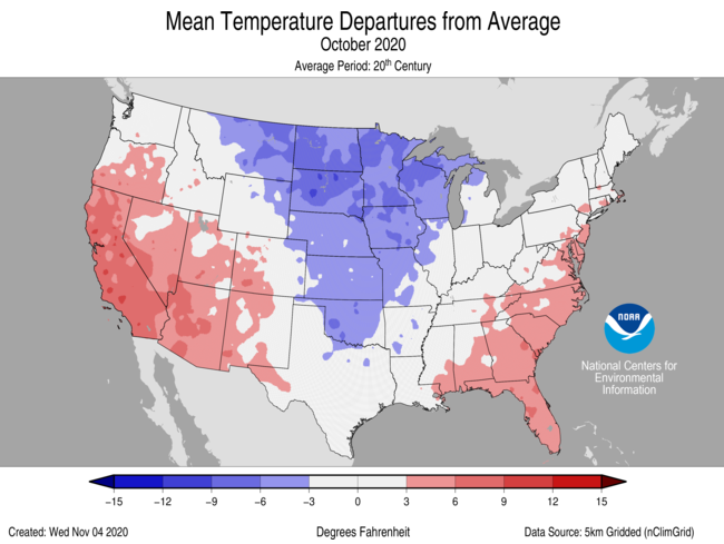

October Temperature
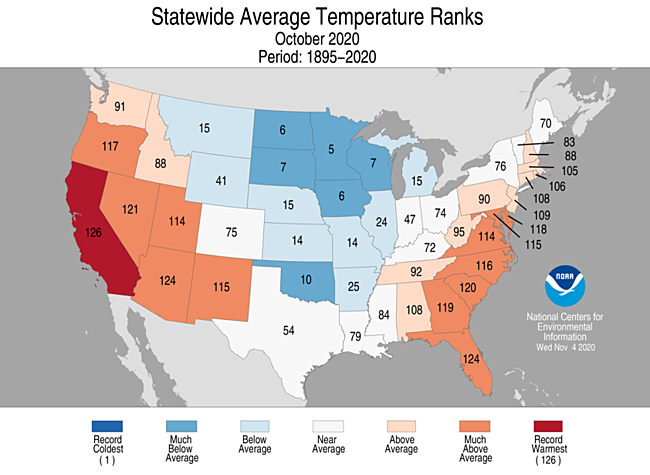
- For October, the average contiguous U.S. temperature was 54.4°F, 0.3°F above the 20th century average. This ranked in the middle third of the 126-year record.
- Above-average temperatures dominated the western U.S., the central Gulf Coast and the East Coast. California ranked warmest on record for October while Arizona and Florida both ranked third warmest.
- Below-average temperatures were observed from the northern Rockies to the Great Lakes and southward to the southern Plains. North Dakota, South Dakota, Minnesota, Iowa, Wisconsin and Oklahoma ranked among their 10 coldest Octobers on record.
- A deep trough of low pressure across the West during the last week of the month allowed unseasonably cold temperatures to plunge into portions of the Rockies, northern Plains and Great Lakes. Record to near-record cold temperatures blanketed the U.S. from the central and southern Rockies to the western Great Lakes during the last week of October. A number of records for cold daily high and low temperatures were broken.
- On October 25, Potomac, Montana, reported a low temperature of −29°F — the coldest temperature on record this early in the season for the contiguous U.S.
- Many stations throughout the Rockies reported below-zero temperatures on the early morning of October 26.
- Alaska ranked in the warmest third of the October record with a statewide average temperature of 29.0°F, 3.5°F above the long-term average. A strong northwest to southeast temperature anomaly gradient existed during October with the warmest anomalies across portions of the West Coast and North Slope and the coolest across the Southeast Interior and the Panhandle. It was the fourth-warmest October for Utqiaġvik (Barrow) and the 19th consecutive such year-to-date period with above normal temperatures.
- The nationally averaged maximum temperature (daytime highs) was warmer than average during October at 67.1°F, 0.3°F above average, ranking in the middle one-third of the 126-year record. California ranked record warmest for maximum temperatures in October, while much of the West and East Coast experienced above-average daytime high temperature for the month. Fourteen states from the northern Rockies and central Plains to the Great Lakes had below-average daytime high temperatures with Wisconsin ranking fourth coldest on record.
- The nationally averaged minimum temperature (overnight lows) during October was 41.7°F, 0.2°F above average, also ranking in the middle one-third of the 126-year record. Florida ranked warmest, while much of the West, Gulf Coast and East Coast experienced above-average overnight low temperatures during October. Fifteen states across the middle third of the U.S. ranked below average for the month
- As of November 9, there were 7,171 daily warm high (3,872) and low (3,299) temperature records tied or broken during October. This was approximately 86 percent of the 8,376 cold daily high (4,508) and low (3,868) temperature records set during the month.
- Based on NOAA's Residential Energy Demand Temperature Index (REDTI), the contiguous U.S. temperature-related energy demand during October was 104 percent of average and ranked in the middle one-third of the 126-year period of record.
October Precipitation
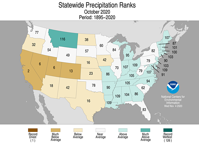
- The October precipitation total for the contiguous U.S. was 2.16 inches, exactly average, ranking in the middle one-third of the 126-year period of record.
- Below-average precipitation was observed across much of the western U.S., the Deep South, central and northern Plains as well as across portions of the Southeast. California ranked second driest on record for October. Nevada and Utah both ranked sixth-driest October on record.
- Above-average precipitation occurred across portions of the northern Rockies, Great Lakes, middle and lower Mississippi Valley, Ohio Valley, Northeast and parts of the Southeast.
- Record daily and monthly snowfall were reported across portions of the West and Plains during the last week of October.
- It was the snowiest October on record for many stations including Spokane, Washington (7.5 inches); Great Falls, Montana (28.0 inches); Minneapolis-St. Paul (9.3 inches) and St. Cloud, Minnesota (7.2 inches); Albuquerque, New Mexico (4.2 inches); Amarillo, Texas (7.4 inches) and Wichita, Kansas (1.6 inches).
- An ice storm associated with the record cold temperatures impacted parts of the central and southern Plains on October 27. More than 350,000 residents in central and southwestern Oklahoma were without power as freezing rain and ice brought down foliage-filled trees and, subsequently, powerlines. This is the earliest ice storm on record for Oklahoma.
- Across Alaska, October was wet across parts of the North Slope. The Panhandle and Gulf Coast were drier than average for the month.
- According to the November 3 U.S. Drought Monitor, approximately 45 percent of the contiguous U.S. was in drought, up slightly from 42.6 percent at the end of September. Drought conditions intensified across the Four Corners region as well as parts of the northern and central Plains. Drought coverage became less severe across portions of the Northeast. Drought also expanded across Hawaii.
Extremes
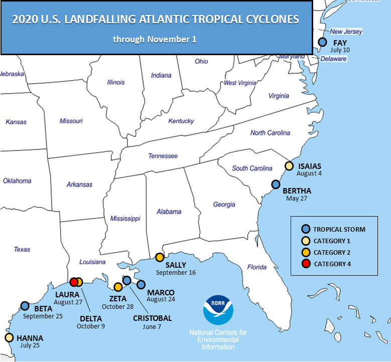
- Above-average tropical activity across the Atlantic Basin continued into October as one tropical storm and three hurricanes developed over the course of the month. With the formation of Tropical Storm Eta on November 1, 28 named storms have formed during 2020, which ties 2005 for the record number of storms in a single season.
- Eleven named U.S. storm continental landfalls have occurred during the 2020 Atlantic hurricane season through November 1. This breaks the previous record of nine landfalls in 1916.
- Through November 1, six hurricanes made landfall in the U.S., which ties 1985 and 1886 for most hurricane landfalls in a single season.
- Hurricanes Delta and Zeta made landfall along the Louisiana coast during October, bringing the total number of landfalling named storms for Louisiana in 2020 through November 1 to five (Cristobal, Marco, Laura, Delta and Zeta). This is a new record for Louisiana and any U.S. state.
- Category 2 Hurricane Delta came ashore on October 9 at Creole, LA, six weeks after Category 4 Laura and approximately 12 miles east of Laura’s landfall location.
- As of November 3, Delta and Eta are the strongest Greek-named hurricanes in the Atlantic on record with maximum sustained winds of 145 mph, exceeding Beta (2005), which had 115 mph maximum sustained winds.
- Category 2 Hurricane Zeta made landfall near Cocodrie, LA, on October 28, joining Kate (1985) and two unnamed storms (1935, 1899) as the only Category 2 storms on record to make mainland U.S. landfall so late in the Atlantic season.
- More than 2.7 million customers from Louisiana to Virginia were without power on October 28 and 29. Widespread damage resulted from storm surge, high winds and flooding rainfall across much of the region as Zeta moved up the East Coast.
- Despite the record pace and tie for number of named storms in the Atlantic, the 2020 tropical cyclone Accumulated Cyclone Energy (ACE) is just barely in the top quartile, or above 165 percent of the 1981-2010 median value.
- Wildfires across Colorado grew rapidly during October. As of November 1, the three largest fires on record in Colorado occurred in 2020. More than three dozen large wildfires continued to burn across the West at month's end. Over 8.5 million acres have burned so far this year, which exceeds the ten-year average.
- The East Troublesome Fire in Colorado is now the state’s second-largest wildfire on record with more than 193,000 acres consumed. In late October, the fire spread rapidly, forcing the evacuation of the entire town of Grand Lake. The 2020 Cameron Peak and Pine Gulch fires are currently the largest and third-largest fires in state history, respectively.
- Near the end of October, wildfire conditions and subsequent activity across California rekindled. Residents in parts of southern California had to evacuate due to dry conditions and strong Santa Ana winds. Nearly 100,000 Orange County residents were forced to evacuate as the Silverado and Blue Ridge fires spread rapidly. Reports of winds in excess of 100 mph were observed along several ridgetop ski resorts on October 25-26. High winds combined with very dry air and fuels created an ideal environment for explosive wildfire activity.
Year-to-Date Highlights

January-October Temperature
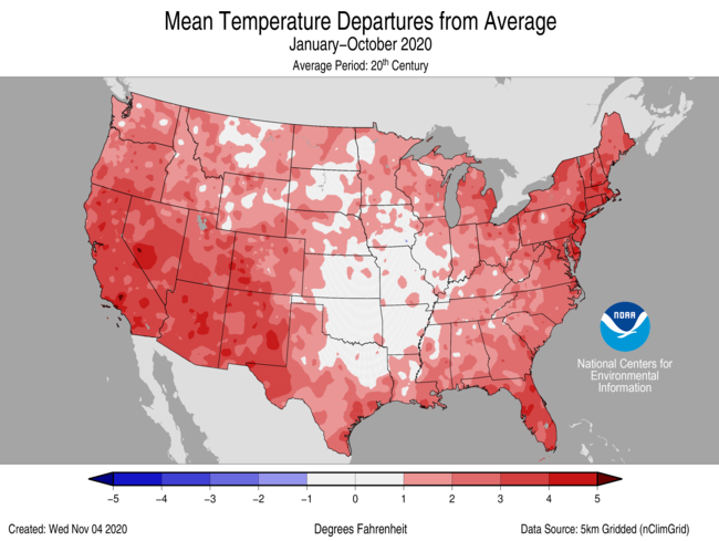
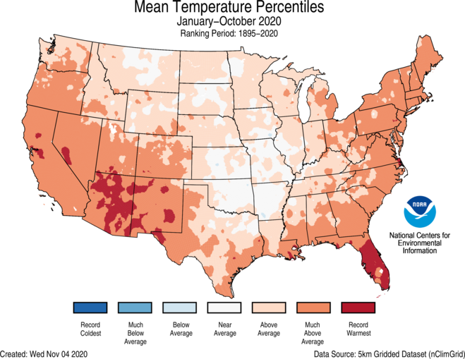
- For the year-to-date, the contiguous U.S. temperature was 57.0°F, 2.1°F above the 20th century average, and tied with 2006 for seventh warmest in the January–October record.
- Above-average year-to-date temperatures were observed across most of the Lower 48. Record warm temperatures were scattered throughout the Southwest and Southeast. Arizona, New Mexico and Florida ranked warmest on record for this 10-month period with six additional states in the West and Northeast ranking among their top-3 warmest January-Octobers on record.
- Near-average temperatures were observed from parts of the northern Rockies to the central Plains. There were no notable regions reporting below-average temperatures for this year-to-date period.
- Temperatures across Alaska ranked in the middle third of the historical record for January-October. Above-average temperatures blanketed much of the West Coast and Aleutians as well as parts of the North Slope. Below-average temperatures were observed in portions of the Northeast and Southeast Interior regions.
- The contiguous U.S. average maximum (daytime) temperature during January-October was 69.1°F, 1.9°F above the 20th century average, ranking eighth warmest in the 126-year record. Above-average maximum temperatures were observed across much of the West, Gulf Coast, Great Lakes and East Coast with Arizona and New Mexico ranking warmest on record. Below-average maximum temperatures were observed across portions of the central and lower-Mississippi River Valley.
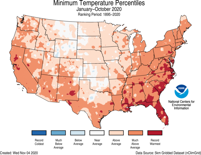
- The contiguous U.S. January-October minimum (nighttime) temperature was 45.0°F, 2.3°F above average, and ranked fifth warmest on record. Above-average minimum temperatures were observed across most of the CONUS. Minimum temperatures averaged across Florida, South Carolina, Virginia and Maryland were record warmest for this year-to-date period. No state ranked near or below average.
- Based on REDTI, the contiguous U.S. temperature-related energy demand during January-October was 52 percent of average and ranked in the lowest one-third of the 126-year period of record.
January-October Precipitation
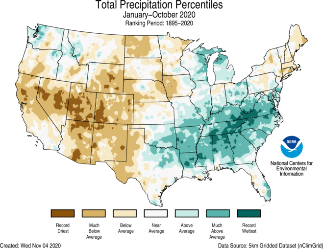
- For the year-to-date, the national precipitation total was 26.30 inches, 0.94 inch above average, ranking in the wettest one-third of the January-October record.
- Above-average January-October precipitation dominated much of the central Gulf Coast, Midwest, Southeast, Great Lakes and parts of the Northwest. Tennessee ranked wettest on record while North Carolina ranked second wettest for this year-to-date period.
- Below-average year-to-date precipitation occurred across the West, parts of the northern and central Plains as well as the Northeast. Utah ranked driest on record while Colorado ranked second driest.
- Across Alaska, year-to-date precipitation was near average. The Aleutians and Gulf Coast were drier than average while portions of the Interior regions received above-average precipitation for the first 10 months of the year.
Extremes
- The USCEI for the year-to-date was 66 percent above average and ranked ninth highest in the 111-year period of record. Extremes in warm maximum and minimum temperatures as well as wet PDSI and days with precipitation contributed to this elevated value.
- On the regional scale, the Southeast ranked highest on record for January-October. Elevated extremes were due to widespread warm maximum and minimum temperatures, wet PDSI, extremes in heavy 1-day precipitation and the number of days with precipitation. Across the Northern Rockies and Plains, the year-to-date regional CEI was 24 percent below average and ranked in the middle third of the record. Wet PDSI was the only above-average indicator for this region.
Regional Highlights
These regional summaries were provided by the six Regional Climate Centers and reflect conditions in their respective regions. These six regions differ spatially from the nine climatic regions of the National Centers for Environmental Information.
Northeast Region (Information provided by the Northeast Regional Climate Center)
- The Northeast’s average temperature for October was 51.1 degrees F (10.6 degrees C), 1.7 degrees F (0.9 degrees C) warmer than normal. All twelve Northeast states had a warmer-than-normal October with average temperatures ranging from 0.7 degrees F (0.4 degrees C) above normal in Maine to 4.1 degrees F (2.3 degrees C) above normal in Delaware. This October ranked among the 20 warmest on record for six states: Delaware, ninth warmest; Maryland, 11th warmest; Rhode Island, 14th warmest; Connecticut, 16th warmest; New Jersey, 17th warmest; and Massachusetts, 19th warmest.
- During October, the Northeast received 4.33 inches (109.98 mm) of precipitation, 112 percent of normal. Ten states were wetter than normal, with precipitation for all twelve states ranging from 98 percent of normal in New York to 149 percent of normal in Delaware, its 18th wettest October on record. In addition, Maine had its 20th wettest October.
- The U.S. Drought Monitor released on October 1 showed 45 percent of the Northeast in an extreme, severe, or moderate drought and 25 percent as abnormally dry. During the month, beneficial rainfall improved drought conditions in portions of New England, most notably in northern and western Maine; however, drought and abnormal dryness expanded or intensified in New York, Pennsylvania, northern West Virginia, and western Maryland. The U.S. Drought Monitor released on October 29 showed 47 percent of the Northeast in an extreme, severe, or moderate drought and 24 percent as abnormally dry. There were numerous impacts from the drought and abnormally dry conditions. During October, streamflow and groundwater levels continued to be below normal in many of the drought areas, with some sites setting daily record low streamflows. Lower than usual streamflow on the Hudson River in New York led to increased sodium levels in Poughkeepsie’s water supply. Some lake levels in New Hampshire were the lowest they had been in decades. Water restrictions were enacted or remained in place for numerous locations in Massachusetts and several locations in Connecticut, Maine, New York, and Pennsylvania. As of October 28, 167 community water systems, eight municipalities, and some private well users in New Hampshire had restrictions in place. In addition, dry wells were reported in New England. Assistance was available for low-income residents in New Hampshire that use private wells and were experiencing little or no water because of the drought. Aquarion Water Company issued a mandatory ban on automatic irrigation systems and sprinklers and revoked irrigation variances for customers in southwest Fairfield County, Connecticut, which hit its third drought trigger. Worcester, Massachusetts, took one of its reservoirs offline due to drought-related low water levels. With drought conditions and an old, leaky water system, the Emerald Lake Village District in Hillsborough, New Hampshire, had spent more than $110,000 to haul in water. A lower-than-usual water table has helped construction along the waterfront in Bangor, Maine, to move ahead of schedule. Agriculture continued to suffer. In late October, potato yields were expected to be down by more than 20 percent in northern Maine. One Massachusetts farmer reported drought-related expenses of more than $50,000. Some cranberry growers in Massachusetts reported losses due to a lack of water from drought conditions. Christmas trees in Massachusetts were affected by the drought, with one farm losing around a third of its saplings. With reduced yields, a farm in Vermont had to buy hay for its cows at a cost of $15,000 to $20,000. Drought conditions in Connecticut slowed maple syrup production, with one producer expected to lose around $60,000 in revenue. Portions of New England were designated as natural disaster areas by the U.S. Department of Agriculture, making some farmers eligible for federal assistance. Fall foliage peaked earlier than usual in portions of northern New England and New York, while drought-stressed trees in southern New England dropped leaves prematurely. This year’s drought could affect next year’s foliage display in the region and reduce next year’s growth of red oak and white pine trees in New Hampshire. Fire risk remained elevated in areas of New England, New York, and Pennsylvania that were experiencing drought and abnormal dryness. In Massachusetts, there were 52 fires in a nine-day period from late September to early October. The state’s fire tower network was extended due to the increased fire risk. Low water levels were reported in fire suppression ponds in eastern Connecticut. After beneficial rain in mid-October, New Hampshire lifted its fire ban for public woodlands.
- On October 7, a derecho produced a 320-mile (515 km) long path of damage from central New York to eastern New England. Winds gusted to 82 mph (37 m/s), with locally higher gusts of up to 100 mph (45 m/s) in eastern New York. The Albany International Airport in New York recorded a wind gust of 67 mph (30 m/s), its highest October wind gust since 1987. In addition, there were two EF-0 tornadoes, one in eastern New York and one in eastern Massachusetts. Numerous trees and branches were felled due to a combination of strong winds, drought stress, and being fully leafed. There were more than 120 wind damage reports in western New England and eastern New York, where there were two storm-related fatalities. In addition, almost 400,000 customers lost power. The remnants of Hurricane Delta and a frontal system teamed up to produce widespread rainfall in the Northeast from October 12 to 14. The greatest totals of more than 3 inches (76 mm) were reported in parts of New Jersey, Connecticut, Massachusetts, and Maine. The rainfall was much-needed across drought-stricken areas of New York and New England. For instance, Caribou, Maine, which was experiencing extreme drought conditions, picked up 2.45 inches (62.23 mm) of rain from October 13 to 14, making it the site’s largest two-day precipitation total since October 2017. Tropical Storm Zeta and another storm system trekked through the Mid-Atlantic, bringing rain, snow, and gusty winds to the region from October 29 to 30. Rainfall totals were generally less than 3 inches (8 cm), with higher amounts in northern West Virginia, south-central Pennsylvania, and central and southern Maryland. Flooding led to road closures in portions of Maryland and Delaware. Snow fell across portions of New England, New York, northern Pennsylvania, and northern New Jersey, with the greatest snowfall totals at least 6 inches (15 cm) in central and eastern Massachusetts. With 4.3 inches (10.92 cm) of snow, Boston, Massachusetts, had its snowiest October (old record was 1.1 inches [2.8 cm] in 2005) and snowiest October day on record. Providence, Rhode Island, picked up 1.6 inches (4.1 cm) of snow on October 30, tying as the site’s snowiest October day on record. Several other locations had one of the five snowiest Octobers on record. Some branches and wires were downed in parts of Massachusetts due to snowfall and/or gusty winds. Wind gusts of up to 50 mph (22 m/s) were recorded in several coastal locations of Maryland, Delaware, and New Jersey, where some coastal flooding occurred.
- For more information, please visit the Northeast Regional Climate Center Home Page.
Midwest Region (Information provided by the Midwest Regional Climate Center)
- October temperatures were well below normal in the northwestern Midwest and near normal in the southeastern Midwest. Regionwide temperatures were 47.9 degrees F (8.8 C) which was 3.1 degrees F (1.7 C) below normal. October ranked as the 13th coldest on record (1895-2020). Minnesota ranked as the 5th coldest in its history, while Iowa ranked 6th and Wisconsin ranked 7th in their respective histories. All of Minnesota along with half of Iowa and Wisconsin, were at least 5.0 degrees F (2.8 C) below normal. In contrast, nearly all of Indiana, Ohio, and Kentucky were within 2.0 degrees F (1.1 C) of normal. The cool conditions in the northwestern part of the region were primarily from a cold 10-day stretch in the latter half of October. In Minneapolis, Minnesota, maximum daily temperatures were below the normal minimum temperatures from the 18th through the 27th. In contrast, Lexington, Kentucky had warm temperatures during a similar stretch from the 19th to the 29th. During that 11-day period, Lexington’s daily maximum temperatures were above normal on five days while its daily minimum temperatures were above normal on all 11 days. For the region in October, there were more than 1400 record low daily temperatures and fewer than 200 record high daily temperatures.
- October precipitation ranged widely across the Midwest leaving the regionwide total near normal. The regional total was 3.13 inches (80 mm) which was just 0.12 inches (3 mm) above normal. Values ranged from less than 25 percent of normal to more than 200 percent of normal. Two areas with less than 50 percent of normal were located in the western half of the region. One was in northwestern Minnesota and the other stretched across northern Missouri and the southern edge of Iowa into west central Illinois. There were also two swaths that had more than 150 percent of normal precipitation. One that stretched across central Wisconsin and into northern Michigan and another that stretched across southern Missouri, along the Ohio River and up to the southwestern shore of Lake Erie. In Missouri alone, precipitation totals ranged from more than 6.00 inches (152 mm) in the south to less than 1.00 inches (25 mm) in the northwest. More than 400 daily precipitation records were set in October with at least 20 in each Midwest state.
- October snowfall in the Midwest was generally above normal in the northwestern half of the region where snow fell. Snowfall was at least 6.0 inches (15.2 cm) above normal for much of Minnesota along with parts of northwestern Wisconsin and Upper Michigan. Some locations in west central Minnesota and western Upper Michigan had about 12 inches (30.5 cm) above normal. The western shore of Lower Michigan had slightly below-normal snowfall in October. Nearly 300 daily snowfall records fell in October with 265 of the records in Minnesota (131), Iowa (69), and Wisconsin (65). Nearly all of the daily snowfall records occurred between the 18th and the 27th. Monthly snowfall records also fell in more than 50 locations. Monthly records were broken in cities with long periods of record such as Minneapolis-St. Paul (142-year record), St. Cloud, Minnesota (126-year record), Marquette, Michigan (136-year record), Eau Claire, Wisconsin (128-year record), and Rhinelander, Wisconsin (102-year record).
- Drought in the Midwest peaked mid-month with nearly 17 percent of the region in drought before dropping off to under 12 percent later in the month. The area of the region in severe drought remained around 4 to 5 percent and the area in extreme drought remained around 0.5 to 1.0 percent of the region in October. The areas of extreme drought were located in northwestern Iowa and southwestern Missouri. Severe drought was primarily in Iowa and Missouri, but also extended into small parts of southwestern Minnesota and central Illinois as well during October.
- Severe weather in the Midwest was primarily on two days in October. Iowa and Minnesota had nearly two dozen reports of severe weather on the 11th, mostly strong thunderstorm winds but also including a report of hail up to 2.50 inches (64 mm) in diameter near Ortonville, Minnesota. Then on the 23rd, there were dozens of strong wind reports along with some large hail reports in Ohio, Michigan, Kentucky, and Indiana. There were no injuries reported and most of the damage was downed trees and limbs.
- For further details on the weather and climate events in the Midwest, see the weekly and monthly reports at the Midwest Climate Watch page.
Southeast Region (Information provided by the Southeast Regional Climate Center)
- Temperatures were above average across much of the Southeast region and Puerto Rico for the month of October. Monthly mean temperatures were at least 3 degrees F (1.7 degrees C) above average for over 60 percent of the 149 long-term (i.e., period of record equaling or exceeding 50 years) stations across the region. There were four stations that observed their warmest October on record including, Tampa, FL (1890-2020) and Clayton, NC (1955-2020). Maximum temperatures ranged from 4.9 degrees F (2.7 degrees C) above normal in Eastman, GA (1891-2020) to 2.6 degrees F (1.4 degrees C) below normal in Oneonta, AL (1894-2020). Daily temperature minimums ranged from 10 degrees F (5.6 degrees C) above normal in Marion, NC (1893-2020) to 0.6 degrees F (0.3 degrees C) below normal in Roosevelt Roads, PR (1942-2020). More than 77 percent of the long-term stations observed monthly minimum temperatures that were at least 3 degrees F (1.7 degrees C) above average. Nighttime cooling was suppressed on a number of days due to the presence of clouds and tropical moisture. Indeed, there were a few stations in Florida that saw average minimum temperatures above 75 degrees F (23 degrees C) for the month including, West Palm Beach, FL (1888-2020; 2nd warmest) at 75.8 degrees F (24 degrees C) and Miami, FL (1895-2020; 2nd warmest) at 76.8 degrees F (25 degrees C). The warmest weather of the month occurred from the 7th through the 9th, as the circulation around the Bermuda High, situated off the Atlantic coast, transported warm, humid air over much of the Southeast region. Daily maximum temperatures exceeded 80 degrees F (27 degrees C) across portions of every state, with parts of Florida exceeding 90 degrees F (32 degrees C). Indeed Tampa, FL (1890-2020), had a daily maximum temperature of 95 degrees F (35 degrees C) on the 8th setting a daily record. In contrast, the coolest weather of the month across the Southeast occurred on the 17th and 18th, as the circulation around a departing mid-latitude cyclone ushered in relatively cooler and drier air from Canada. Daily minimum temperatures fell below 40 degrees F (4.4 degrees C) across portions of every state north of Florida, with a few locations in the higher elevations of North Carolina and Virginia falling below 30 degrees F (-1.1 degrees C), prompting frost and freeze advisories. Indeed, Mt Mitchell (1925-2020) had a minimum temperature of 24 degrees F (-4.4 degrees C).
- Precipitation was variable across the Southeast region during October, with a few wet and dry extremes recorded. The driest locations were found across eastern Georgia, central South Carolina, eastern North Carolina, and the Panhandle of Florida. Monthly precipitation totals ranged from 50 to less than 25 percent of normal across these locations. Laurinburg, NC (1946-2020; 4th driest) only received 0.43 inches (11 mm) of precipitation, over 3 inches (76 mm) below normal for the month. In contrast, the wettest locations were located across central Alabama, northern Georgia, western North Carolina, and central Virginia. Precipitation totals ranged from 150 to 300 percent of normal. Indeed, Gainesville, GA (1891-2020) received 10.76 inches (273 mm) of precipitation, which was more than 6 inches (152 mm) above average, making this the 1st wettest October on record. Most of Puerto Rico and the US Virgin Islands received normal amounts of precipitation for the month. Hurricane Delta was the ninth hurricane of the Atlantic 2020 season and made landfall near Creole, LA on October 9th. From the 10th - 11th, precipitation from the remnants of Hurricane Delta impacted parts of the Southeast with numerous reports of localized flooding. Atlanta, GA (1878-2020) received 4.55 inches (116 mm) of rain from the storm in a single day, making it the 2nd wettest October day on record. Towards the end of the month Hurricane Zeta made landfall near Cocodrie, LA on October 28th, and over the next two days dropped 3-5 inches (76-127 mm) of precipitation across parts of the Southeast. Highlands, NC (1877-2020) reported 6.18 inches (157 mm) of rainfall from the storm.
- There were 30 reports of severe weather across the Southeast during October, which is 65 percent of the median monthly frequency of 46 reports during 2000-2018. There were 13 confirmed tornadoes reported for the month (9 EF-0, 4 EF-1), about 130 percent of the monthly average of 10. All of these tornadoes were associated with Hurricane Delta. The strongest of these tornadoes was rated EF-1 with winds of 105 mph (47 m/s), and occurred in Dillon County, SC on October 11th. This tornado destroyed a storage shed and snapped several large pine trees in its path. No injuries or fatalities were reported. Another EF-1 tornado with winds of 90 mph (40 m/s) occurred in Newton County, GA on October 10th. This tornado damaged the roof and walls of a homeless shelter causing 2 injuries. There were no reports of hail for the month and only 17 wind reports for the month, which is 53 percent of the average (32 reports). Hurricane Zeta made landfall near Cocodrie, LA on October 28th, with peak winds of 110 mph (49 m/s). A wind gust of 91 mph (41 m/s) was reported in Mobile, AL. Farther inland, winds gusted over 50 mph (22 m/s) in parts of northern GA, upstate SC, and NC, including a 57 mph (25 m/s) gust reported in Columbus, GA and a 55 mph (24 m/s) gust in Hickory, NC. Widespread power outages were reported with Hurricane Zeta as well as numerous reports of damaged or downed trees. Unfortunately, there were 8 fatalities from Hurricane Zeta, including in Acworth, GA where a large oak tree was uprooted and fell on a mobile home killing a man.
- The entire Southeast region and Puerto Rico remained drought-free for the month of October. At the beginning of the month, small pockets of abnormally dry conditions (D0) were found in Georgia, Alabama, and southern Puerto Rico. By the end of the month these pockets of dryness (D0) expanded slightly in Georgia, South Carolina, and southern Puerto Rico. Many farmers in the Florida Panhandle reported a loss of cotton due to the heavy rains and wind brought by Hurricane Zeta. While most peanuts were dug and harvested, many farmers in the Panhandle also noted fungal issues. Growers had to irrigate the groves, as modest amounts of precipitation fell in the citrus growing region of Florida. In Alabama, greenhouses and plastic bedding on vegetables were significantly damaged or destroyed by Hurricane Zeta. High soil moisture after the hurricane prevented fieldwork in many areas. Soybean condition declined and cotton was damaged depending on where in the state it was located. Farmers in Georgia noted an increase in boll rot in cotton as a result of the rain from Hurricane Zeta. The rain, however, kept livestock pastures in good condition. Abnormally dry conditions expanded slightly in the Midlands and Lowcountry of South Carolina and although the young strawberry crop looked good, there were some reports of spider mites. Overall, however, vegetables were growing well.
- For more information, please visit the Southeast Regional Climate Center Home Page.
High Plains Region (Information provided by the High Plains Regional Climate Center)
- Overall, it was a dry month for the High Plains, with much of the region experiencing an intensification of drought conditions. Perhaps the most notable impact of drought this month was the continuation of wildfires raging across Colorado and, to a lesser extent, Wyoming. The Cameron Peak Fire, which ignited on August 13th, grew to become the largest wildfire in Colorado history in October, surpassing the Pine Gulch Fire, which in August had just become the largest in state history. At the time of this writing, the Cameron Peak Fire was 92 percent contained and had burned 208,913 acres in and around the Roosevelt National Forest. Another destructive fire, the East Troublesome Fire, ignited on October 14th to the southwest of the Cameron Peak Fire. Warm temperatures, low relative humidities, and high winds produced ideal conditions for this fire to spread quickly, growing by an astonishing 100,000 acres in one night. This prompted the rapid evacuation of the town of Grand Lake. Unfortunately, two people died in this fire after being trapped in their basement. The fire jumped the Continental Divide and into Rocky Mountain National Park, forcing the closure of the Park and mandatory evacuations for the tourist town of Estes Park. Luckily, at the time of this writing, the fire had not spread any further, sparing the town. Snowfall and cooler temperatures toward the end of the month helped ease fire conditions. However, the fire was only 37 percent contained as of November 6th and it bears watching.
- One benefit of the dryness was that producers were able to get out in the fields and harvest their crops. As of the end of October, all High Plains states were ahead of the 5-year average for both corn and soybean harvest. In fact, Nebraska and North Dakota had completed soybean harvest by the end of the month. Despite drought conditions, corn and soybeans fared pretty well throughout the region. North Dakota and South Dakota are expected to have record corn yields this year. However, drought conditions have caused winter wheat to struggle. More than 20 percent of the winter wheat crop was rated poor or very poor in Colorado, Kansas, and Nebraska, and more moisture is needed to ensure sufficient growth.
- Below-normal temperatures prevailed throughout a large part of the High Plains in October. Departures generally ranged from 2.0-8.0 degrees F (1.1-4.4 degrees C) below normal, with the Dakotas experiencing the greatest departures. Numerous locations throughout the region ranked among the top 10 coolest Octobers on record, with several locations in the Dakotas ranking among the top 5. The only area that experienced above-normal temperatures in October was western and central Colorado, where departures were up to 4.0 degrees F (2.2 degrees C) above normal.
- October started off rather warm, with many locations experiencing above-normal temperatures for the first half of the month. However, the second half of October turned colder, with much of the region experiencing daily departures of at least 20.0 degrees F (11.1 degrees C) below normal for a few days. Not only did numerous locations break daily records for minimum temperature, but some places had their coldest October temperature on record, including Akron, CO, Pueblo, CO, Goodland, KS, Chadron, NE, Scottsbluff, NE, Rapid City, SD, and Laramie, WY. Temperatures reached as low as -10.0 degrees F (-23.3 degrees C) in Chadron on the 26th, which crushed the previous record for lowest October temperature of 0.0 degrees F (-17.8 degrees C), set just last year (period of record 1941-2020). In Laramie, the temperature plummeted to -26.0 degrees F (-32.2 degrees C) on the 27th, obliterating the previous record of -18.0 degrees F (-27.8 degrees C) set in 1993 (period of record 1948-2020). It is interesting to note that Laramie’s record for coldest November temperature is also -26.0 degrees F (-32.2 degrees C), occurring in late November, so to record a temperature this low nearly a month prior is quite impressive.
- October was another dry month throughout the High Plains region. Precipitation was less than 50 percent of normal across much of North Dakota, Nebraska, Wyoming, Colorado, eastern South Dakota, and northern Kansas. Some locations received very little precipitation, which placed this October among the top 10 driest Octobers on record. Laramie, Wyoming and Akron, Colorado had their driest, receiving only a trace of precipitation and 0.01 inch (less than 1 mm), respectively. The persistent dryness contributed to the intensification of drought conditions throughout the region. While the majority of the High Plains was dry, a few areas received above-normal precipitation in October, including northern Wyoming and southern Kansas. However, these areas experienced only local improvements in drought conditions.
- Despite the region-wide dryness, some locations received impressive snowfall from a couple of systems. A particularly powerful storm system came through the 24th-25th, bringing snow and frigid temperatures to northern and central portions of the Rockies and Plains. Ultimately, the following locations ranked among the top 5 snowiest Octobers on record: Mobridge, SD (snowiest); Sisseton, SD (snowiest); Aberdeen, SD (2nd snowiest); Fargo, ND (2nd snowiest); Wichita, KS (2nd snowiest); Pierre, SD (3rd snowiest); Huron, SD (4th snowiest); Pueblo, CO (4th snowiest); Grand Junction, CO (4th snowiest); Norfolk, NE (4th snowiest); and Lincoln, NE (5th snowiest). Cheyenne, WY received an impressive 1-day snowfall total of 14.0 inches (36 cm), which was its highest 1-day total snowfall on record for October, smashing the previous record of 8.9 inches (23 cm) set in 1906 (period of record 1883-2020).
- A separate storm system originating from the southern Rockies tracked across southern Kansas on the 28th-29th, and with rich Gulf moisture in place thanks to Hurricane Zeta, this region received heavy rainfall. Most locations reported 1.00-4.00 inches (25-102 mm) of precipitation, with locally higher amounts. While this precipitation was beneficial for easing drought conditions, unfortunately some locations received freezing rain, causing ice accumulations of at least 0.1 inch (less than 1 cm). This amount of ice was enough to create hazardous road conditions, as well as downed trees and power lines. The city of Winfield was hit particularly hard. According to the National Weather Service in Wichita, Winfield received 0.5 inch (1 cm) of ice and citizens reported hearing trees snapping.
- According to the U.S. Army Corps of Engineers, upper Missouri Basin runoff this year is forecast to be 30.2 million acre-feet, which is approximately 4 million acre-feet above the long-term average. While saturated soils during the spring led the Corps to expect another high runoff year, the rapid development and intensification of drought throughout much of the Basin during the summer and fall prevented that from happening. As for streamflows in the region, they were mostly normal to above normal in October throughout the Dakotas, Nebraska, and Kansas, thanks in part to melting snow from the winter storm that passed through the region toward the end of the month. However, not surprisingly, streamflows were much below normal throughout the majority of Colorado and Wyoming where drought conditions were most intense.
- Dry conditions in October led to continued development and intensification of drought throughout the High Plains. According to the U.S. Drought Monitor, the area experiencing drought (D1-D4) increased from approximately 62 percent to 71 percent over the course of the month. By the end of October, over 98 percent of the region was experiencing drought or abnormal dryness (D0-D4).
- Exceptional drought (D4) increased in areal coverage across Colorado, expanding into northwestern, southwestern, and central parts of the state. Extreme drought (D3) spread into eastern Colorado and further expanded in Wyoming and the Nebraska Panhandle, reaching into southwestern South Dakota and western Kansas. D3 developed in southeastern South Dakota as well. Severe drought (D2) expanded across western and central North Dakota, western Wyoming, southern and eastern areas of Nebraska, and northwestern Kansas. Moderate drought (D1) developed in portions of central and eastern Kansas, while abnormally dry conditions (D0) developed across the rest of the state.
- Only minor improvements in drought conditions occurred in October. D3 was removed from eastern Nebraska and slightly reduced in southern Colorado and northern Wyoming. Meanwhile, D1 was reduced in northeastern and west-central South Dakota. Localized precipitation in mid-October brought relief to eastern Nebraska, while other areas were fortunate to receive enough precipitation from the late-October winter storm to improve conditions.
- For more information, please visit the High Plains Regional Climate Center Home Page.
Southern Region (Information provided by the Southern Regional Climate Center)
- Temperatures for the month of October varied spatially across the Southern Region, with cooler than normal temperatures in the north and west while temperatures were warmer than normal in the south and east. Parts of northern and central Arkansas, northern, north-central, and northeastern Texas, and northern, western, southern, and eastern Oklahoma experienced temperatures 2 to 4 degrees F (1.11 to 2.22 degrees C) below normal, while parts of western Tennessee, northern and central Louisiana, northern, eastern, and southern Texas, central and eastern Oklahoma, and most of Arkansas experienced temperatures 0 to 2 degrees F (0.00 to 1.11 degrees C) below normal. Conversely, parts of western, southern, and eastern Texas, western and northern Louisiana, central and northeastern Mississippi, and western Tennessee experienced temperatures 0 to 2 degrees F (0.00 to 1.11 degrees C) above normal, while parts of western Texas, southeastern Louisiana, southern and eastern Mississippi, and central and eastern Tennessee experienced temperatures 2 to 4 degrees F (1.11 to 2.22 degrees C) above normal. The statewide monthly average temperatures were as follows: Arkansas – 59.60 degrees F (15.33 degrees C), Louisiana – 68.40 degrees F (20.22 degrees C), Mississippi – 65.90 degrees F (18.83 degrees C), Oklahoma – 57.40 degrees F (14.11 degrees C), Tennessee – 60.50 degrees F (15.83 degrees C), and Texas – 65.90 degrees F (18.83 degrees C). The statewide temperature rankings for October were as follows: Arkansas (twenty-fifth coldest), Louisiana (forty-eighth warmest), Mississippi (forty-third warmest), Oklahoma (tenth coldest), Tennessee (thirty-fifth coldest), and Texas (fifty-fifth coldest). The region as a whole experienced its fifty-fourth coldest October on record. All state rankings are based on the period spanning 1895-2020.
- Precipitation values for the month of October varied spatially across the Southern Region. Parts of central and southwestern Arkansas, southeastern and northwestern Louisiana, southern and western Oklahoma, and northern, central, eastern, western, and southern Texas received 50 percent or less of normal precipitation. Parts of southwestern Arkansas as well as eastern, central, western, and southern Texas received 25 percent or less of normal precipitation, while parts of western and southern Texas received 2 percent or less of normal precipitation. In contrast, parts of northwestern Oklahoma, northern Texas, central and southwestern Louisiana, northwestern and eastern Arkansas, southeastern Mississippi, and central and eastern Tennessee received 150 percent or more of normal precipitation, while parts of northwestern Arkansas, north-central Louisiana, and western Tennessee received precipitation 200 percent or more of normal. The statewide precipitation totals for the month were as follows: Arkansas – 4.59 inches (116.59 mm), Louisiana – 5.70 inches (144.78 mm), Mississippi – 5.18 inches (131.57 mm), Oklahoma – 3.12 inches (79.25 mm), Tennessee – 4.88 inches (123.95 mm), and Texas – 0.96 inches (24.38 mm). The state precipitation rankings for October were as follows: Arkansas (thirty-seventh wettest), Louisiana (eighteenth wettest), Mississippi (eighteenth wettest), Oklahoma (forty-ninth wettest), Tennessee (twenty-second wettest), and Texas (sixteenth driest). The region as a whole experienced its thirty-first wettest October on record. All state rankings are based on the period spanning 1895-2020. Drought and Severe Weather:
- At the end of October, drought conditions mainly deteriorated across the Southern Region. Exceptional drought conditions expanded and persisted across western and northwestern Texas. Extreme drought conditions persisted across parts of Oklahoma and Texas, with new areas developing or expanding across southwestern and western Oklahoma as well as northern, western, and southwestern Texas. Severe drought classifications expanded across western Oklahoma as well as northern, western, southern, and central Texas. Moderate drought classifications expanded or developed across northern and western Oklahoma as well as northern, western, central, southern, and eastern Texas, while moderate drought conditions persisted across northwestern Arkansas. There was an increase in the overall area experiencing abnormally dry conditions, with conditions developing or expanding across northeastern, northern, central, and western Oklahoma; northern, southern, eastern, and central Texas; southeastern and northwestern Louisiana; and northwestern Arkansas. There was slight improvement across northwestern and southeastern Mississippi, as abnormally dry conditions contracted or were eliminated.
- In October, there were approximately 14 storm reports across Texas, Arkansas, Tennessee, and Mississippi. There were 3 tornado reports, 2 hail reports, and 9 wind reports. Mississippi tallied the most tornado (3) and wind (4) reports while Tennessee tallied the most hail reports (2). Mississippi tallied the most reports (7) while Louisiana and Oklahoma did not tally a single report. Mississippi was the only state to report tornadoes while Tennessee was the only state to report hail.
- Two tropical cyclones impacted the Southern Region in October. Southwestern Louisiana, still dealing with the damage from Hurricane Laura, experienced its second hurricane landfall of the year as Hurricane Delta made landfall south of Lake Charles on October 9 before moving northeastward across the region. Southeastern Louisiana and southern Mississippi experienced a hurricane almost three weeks later as Hurricane Zeta made landfall south of New Orleans on October 28 before moving northeastward. Storm surge in excess of 8 feet (2.44 meters) MSL was reported for both storms. Parts of southwestern Louisiana reported rainfall totals greater than 15 inches (381 mm) due to Hurricane Delta, while parts of southeastern Louisiana and southern Mississippi reported rainfall totals greater than 5 inches (127 mm) due to Hurricane Zeta.
- On October 9, 2020, an EF-0 tornado was reported near McCall Creek, Mississippi. No injuries were reported.
- On October 23, 2020, a wind gust of 60 mph (96.56 kph) was reported near Granbury, Texas. Additional wind reports across Texas, Arkansas, Tennessee, and Mississippi detailed damage to trees and rooftops.
- On October 28, 2020, two tornado reports were issued in Noxubee County, Mississippi, detailing damage to trees and power lines.
- For more information, please visit the Southern Regional Climate Center Home Page.
Western Region (Information provided by the Western Region Climate Center)
- After a quiet start to the month, an active weather pattern developed in the Pacific Northwest into the northern Rockies beginning around October 10th and persisting through the rest of the month bringing below normal temperatures and above normal precipitation. Temperatures in Montana were well below normal across much of the state with well above normal precipitation (150%-400% of normal) in the northwest part of the state. Tranquil weather persisted through the entire month beneath a ridge of high pressure over California, Nevada, Arizona, and Utah leading to well above normal temperatures and below normal precipitation. California saw its warmest October on record and fourth driest which allowed several large, active wildfires to continue burning and produced ongoing degraded air quality from wildfire smoke.
- A series of cold, wet storms brought substantial rain and early season snow to Washington, northern Idaho, and Montana. For Great Falls, Montana it was the fourth wettest with 2.04” of precipitation (51.8 mm, 237% of normal) and cold temperatures led to the snowiest October on record with 28” (711 mm) dating back to 1937, and beating out the old record of 17” (432 mm) set just last year in 2019. For nine days in a row between October 16th and 25th Great Falls saw measurable snowfall with the single greatest accumulation of 8.2” (208 mm) on the 18th. Missoula, Montana also set a record for monthly snowfall at 14.2” (361 mm) and recorded the second wettest October since 1948 with 2.96” (75 mm, 336% of normal). These storms helped to dampen the fire season in the region, but at the end of October there were still several large wildfires burning in central Idaho and along the Idaho-Montana border.
- Warm and dry conditions persisted across Oregon, California, Nevada, Utah, and Arizona worsening drought conditions and allowing the fire season to extend well into Autumn. San Francisco, California logged its fourth warmest October at 65.2 °F (18.4 °C), +3.7 °F (+2 °C) above normal, since records began in 1875. In the northern Sierra Nevada, Tahoe City, California saw no precipitation in the month (normal is 2.07” or 52.6 mm) for only the fourth time since records began in 1909 and recorded its eighth warmest October at 50 °F (10 °C), +4.4 °F (+2.4 °C) above normal. Phoenix, Arizona recorded its fourth warmest October since 1933 at 80.9 °F (27.2 °C), +4.2 °F (+2.4 °C) above normal.
- While southern coastal California remains drought free, drought persists across the rest of Oregon, California, Nevada, Utah, and Arizona with large areas of extreme and exceptional drought according to the US Drought Monitor at the end of October. Utah had the most widespread drought with 59% of the state in extreme drought and 29% in exceptional drought. In northern California, the states two largest reservoirs, Lake Shasta and Lake Oroville, are now at 78% and 71% of normal, respectively, mostly due to exceptionally dry conditions over the past year.
- In Alaska, temperatures were generally above normal except for the panhandle where temperatures were 1-3 °F below normal. The biggest temperature departures were along the North Slope where Utqiagvik saw its fifth warmest October since 1901 at 25.9 °F (-3.4 °C), +8.7 °F (+4.8 °C) above normal. Precipitation in Alaska was a mixed bag for the month. A small cluster of stations to the southeast of Fairbanks saw the greatest wet departures at 150%-300% of normal while the southern panhandle and southwest Alaska out into the Aleutians saw below normal precipitation. Dutch Harbor, on the west end of the Aleutian chain, recorded 3.4” (86.4 mm) of precipitation, 48% of normal. Moderate drought persisted in the Northwest Arctic Borough; this is only the second time the Borough has experienced moderate drought in the US Drought Monitor since 2000.
- Drought continued to develop and intensify across Hawaii with one or two category degradations on several islands. The eastern side of the Big Island saw below normal precipitation and a large area of drought expansion in October. Extreme drought is now present on the Big Island, Maui, and Molokai. Hilo logged 4.82” (122.4 mm), 49% of normal, making it the tenth driest October since records began in 1949. Kahului, Maui recorded 0.26” (6.6 mm) of precipitation, 22% of normal for the month. Significant Events for October 2020
- California wildifres continue to burn: With little-to-no precipitation during October across the state, large wildfires continue to rage in a record setting season. Five out six of California’s largest wildfires occurred in 2020 and three of those fires continue to burn at the end of October: the August Complex (largest fire complex in California’s history at 1,032,649 acres) in northwest California, the Creek Fire in the southern Sierra Nevada, and the North Complex in the northern Sierra Nevada. The North Complex is also the fifth most destructive fire and the fifth deadliest fire in California’s history.
- October Arctic sea ice extent lowest on record: According to National Snow & Ice Data Center, the October sea ice extent ranked as the lowest (63% of average) in the satellite record. This is the largest departure from average conditions seen in any month in the satellite record at 3.69 standard deviations below the 1981-2010 mean.
- For more information, please go to the Western Regional Climate Center Home Page.