National Highlights

Temperature
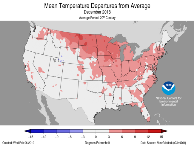
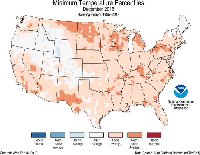
- For December, the average contiguous U.S. temperature was 35.6°F, 2.9°F above the 20th century average, ranking as the 21st warmest in the historical record.
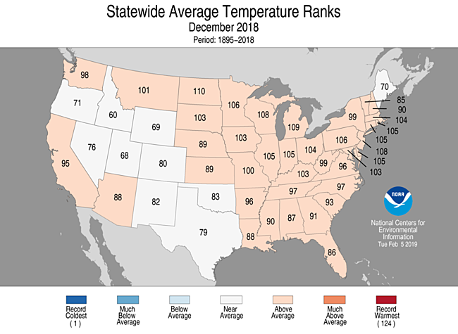
- Above-average temperatures impacted all but ten of the Lower 48 states. No state ranked in the top or bottom ten percent of their history.
- Afternoon high temperatures ranked lower than the overnight low temperatures across the contiguous U.S. Unusually warm overnight temperatures were most notable across the northern High Plains, Great Lakes, parts of the Ohio and Mississippi Valleys as well as the Southwest.
Precipitation
 December 2018 Statewide Precipitation Ranks
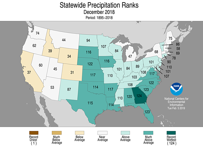
- The December precipitation total for the contiguous U.S. was 3.23 inches, 0.88 inch above average, and ranked seventh wettest in the 124-year period of record.
- Above-to much-above average precipitation fell across a large portion of the eastern two-thirds of the contiguous U.S. Georgia was record wettest, Florida and South Carolina were second wettest while Nebraska and North Carolina were each third wettest on record during December.
- According to the 1 January 2019 U.S. Drought Monitor report, 21.9 percent of the contiguous U.S. was in drought, down slightly since late November. Drought conditions improved across parts of the West and Plains, while moderate drought developed across portions of Florida and expanded in parts of Hawaii and Puerto Rico.
Regional Highlights:
These regional summaries were provided by the six Regional Climate Centers and reflect conditions in their respective regions. These six regions differ spatially from the nine climatic regions of the National Centers for Environmental Information.
Northeast Region: (Information provided by the Northeast Regional Climate Center)
- The Northeast's average temperature for December was 29.3 degrees F (-1.5 degrees C), 0.8 degrees F (0.4 degrees C) warmer than normal. Nine of the region's twelve states were warmer than normal, with average temperatures for all states ranging from 1.6 degrees F (0.9 degrees C) below normal in Maine to 3.3 degrees F (1.8 degrees C) above normal in Delaware.
- December precipitation was 3.98 inches (101.09 mm), 143 percent of normal, for the Northeast. Six states were wetter than normal, with precipitation for all twelve ranged from 88 percent of normal in New Hampshire to 150 percent of normal in New Jersey.
- Abnormally dry conditions in northern New York, northern Vermont, and northern Maine remained unchanged during most of December, with the December 4 U.S. Drought Monitor and the December 25 U.S. Drought Monitor both showing 4 percent of the Northeast as abnormally dry. Precipitation deficits, streamflow, and groundwater levels improved enough in a few spots to warrant some easing of abnormal dryness by early January, with the January 1 U.S. Drought Monitor showing 3 percent of the Northeast as abnormally dry.
- For more information, please go to the Northeast Regional Climate Center Home Page.
Midwest Region: (Information provided by the Midwest Regional Climate Center)
- December precipitation varied from less than 75 percent of normal downwind of the Great Lakes to more than 200 percent of normal in western Iowa. Away from the Great Lakes, much of the region had above-normal precipitation especially along the southern and western edges of the region. Snowfall was below normal for most of the Midwest however much of Minnesota had above-normal snowfall in December. Snowfall deficits downwind of the Great Lakes were as much as 1 to 2 feet (30 to 61 cm) below normal due to the lack of lake-effect snows. The Midwest snow that fell came largely from a storm on the 1st and 2nd that tracked from Iowa to Upper Michigan and then in the last week of the month when heavy snows fell across Minnesota. Annual precipitation for the Midwest was among the highest in history (1895 to present). The record year of 1993 for the region is being challenged by 2018 for the top spot using estimated values for December. The final determination of the 2018 ranking will have to wait for final numbers to be released after the government reopens. Several states in the region were also amongst their wettest on record with Iowa, Kentucky, and Wisconsin likely to rank 2nd wettest, Ohio 3rd wettest, and Indiana 5th wettest. More than 120 Midwest stations set new annual precipitation records (minimum 30 years of records) including dozens of stations with long records (100 or more years). These record-setting stations were spread across eight Midwest state with only Missouri having none. Iowa, Wisconsin, Ohio, and Kentucky had more than a dozen each. In Kentucky, Louisville (146 years in period of record) and Lexington (134 years) set new annual precipitations records. Other stations that also set annual precipitation records included Columbus, Ohio (140 years), Dixon, Illinois (119 years), Green Bay, Wisconsin (132 years), and Waterloo, Iowa (124 years).
- December temperatures were above normal across the Midwest. Temperatures ranged from 2 degrees F (1 C) to 7 degrees F (4 C) above normal with the largest departures in and around Minnesota, Wisconsin, and Iowa. Hundreds of daily record high temperatures were recorded in the region, primarily record high minimum temperatures, while fewer than 10 daily record low temperatures were set. Annual temperatures in the region were within 2 degrees F (1 C) of normal. The southeastern areas of the Midwest were slightly above normal while areas in the northwestern Midwest were slightly below normal. Despite the near-normal annual average temperatures there were big swings of temperature during the year. Big temperature swings occurred several times during the year including a rapid transition from cold to warm in spring and from warm to cool in fall.
- There was a tornado outbreak on December 1st in Illinois with 28 confirmed tornadoes. The most damaging storm was the one that hit Taylorville, Illinois in Christian County. The EF-3 tornado was responsible for 22 of the 23 reported injuries on December 1st and also caused damaged to more than 500 homes in the community. There were no fatalities in the outbreak. Other than the Illinois tornado outbreak, there was little severe weather with a handful of severe weather reports on the 2nd and the 4th and then a more active day on the 31st with tornadoes reported in Indiana and Kentucky and more than a dozen wind damage reports in Kentucky.
- The month of December both began and ended with nor drought in the Midwest according to the US Drought Monitor. During the month, drought reemerged in Missouri but didn't last through the month. As of the US Drought Monitor valid on January 1st, 2019, the Midwest had no drought and the area classified as abnormally dry fell to less than 1 percent of the region, the lowest percentage since May of 2017.
- For further details on the weather and climate events in the Midwest, see the weekly and monthly reports at the Midwest Climate Watch page.
Southeast Region: (Information provided by the Southeast Regional Climate Center)
- Temperatures across the Southeast were warmer than normal in December 2018, except for small pockets of cooler than normal temperatures in Georgia, Virginia, and Florida. Temperatures were generally 2-4 degrees F (1.1 to 2.2 degrees C) warmer than normal across most of the region, except for the Florida Peninsula, where they were primarily 0-2 degrees F (0 to 1.1 degrees C) warmer than normal. Puerto Rico and the U. S. Virgin Islands were also slightly warmer than normal. Key West, FL (1871-2018; 9th warmest) was the only station in the continental Southeast that reached the top ten warmest on record, due to the influence of much warmer than normal ocean temperatures in the surrounding waters. While maximum temperatures were generally only slightly above normal, minimum temperatures throughout the region north of central Florida were 4-6 degrees F (2.2 to 3.3 degrees C) warmer than normal, consistent with general trends seen in the region over time. Sixteen long-term stations (records exceeding 50 years) reported minimum temperatures ranked in the top ten warmest, including Washington D.C. (1871-2018; tied for 9th warmest), Key West, FL (1871-2018; 9th warmest) and Lumberton, NC (1903-2018; tied for 6th warmest). The warmest temperatures of the month generally occurred on December 1-2 in the warm sector ahead of a low pressure system that moved from eastern Kansas northeast through New England. A second period of warm weather occurred at the end of the month in a warm and humid air mass ahead of a strong cold front stretching southward from a powerful low pressure center in Wisconsin and Michigan. During this time period, mean temperatures in northern Florida, most of Alabama, Georgia and the Carolinas were 15-25 degrees F (8.3 to 13.9 degrees C) warmer than the average for the date. Mobile, AL (1871-2018; 1st warmest) reported a minimum temperature of 69 degrees F (20.6 degrees C) on the 31st, almost 29 degrees F (16 degrees C) higher than the normal value for that date. By comparison, the coldest temperature in the Southeast in December occurred in Burkes Garden VA, which reached -9 degrees F (-23 degrees C) on the morning of the 11th. Mount Mitchell, NC reported a low of 7 degrees F (-14 degrees C) on the 6th and the Bell, FL reached a low of 21 F (-6.1 degrees C) on the 19th. The coldest temperature in Puerto Rico in December was 51 degrees F (10.6 degrees C) on the 19th.
- The Southeast was exceptionally wet everywhere in December, except for the southeastern portion of the Florida peninsula and a few small areas of Alabama as well as eastern North Carolina and Virginia. Most of the rest of the region was at least 150 percent wetter than normal, with a large swath of rainfall of more than 300 percent of normal covering most of northern Florida and stretching up the Atlantic Coast to Charleston, SC. The Atlanta, GA metro area also received as much as 300 percent of normal precipitation. Numerous stations reported their wettest December on record, including Pensacola, FL (1879-2018; 16.55 inches or 420 mm), Tallahassee, FL (1896-2018; 15.77 inches or 401 mm), Brunswick, GA (1948-2018; 8.62 inches or 219 mm), Cape Hatteras, NC (1874-2018; 10.92 inches or 277 mm), and Asheville, NC (1869-2018; 10.87 inches or 276 mm). Asheville also reported their wettest single December day on record when 4.17 inches (119 mm) fell on December 9, surpassing their old record of 2.90 inches (73 mm) observed on December 29, 1901. Cape Hatteras, NC also reported their wettest December day on record on December 9, receiving 4.02 inches (102 mm), which surpassed their old record of 3.79 inches (96 mm) from December 6, 1979. In all, 76 long-term stations (more than 50 years of record) reported precipitation amounts ranked in the top three for their sites. The highest monthly rainfall reported in the Southeast was from a CoCoRaHS observer at Gonzales 2.1 E, FL, which received 20.55 inches (522 mm). By comparison, the highest December rainfall in Puerto Rico was 5.21 inches (132 mm) at Palma Sola and in the U. S. Virgin Islands was 2.00 inches (51 mm) at the Christiansted Hamilton Airport. December also brought the first major snowstorm of the year to the Southeast. A low pressure system skirted the Gulf and Atlantic coasts on December 8-10, as a high pressure to the north provided a source of cold air. Liquid precipitation totals ranged from 1.5 to 3 inches (38 mm to 76 mm), with 4.16 inches (106 mm) reported at Cape Hatteras. In the mountains and foothills of North Carolina and Virginia, most of the precipitation fell as snow, yielding widespread accumulations of more than 10 inches. Mount Mitchell, NC reported 32 inches (812 mm), Jefferson, NC received 20 inches (508 mm), and Boone, NC recorded 15 inches (381 mm) of snow. Roanoke, VA reported 15.2 inches (386 mm), most of which fell on the 9th. Many sites receive more than a foot of snow, which is close to the annual average snowfall for those locations. The snow caused power outages that affected nearly 300,000 customers, snarled traffic, and led to the cancellation of hundreds of flights in the region. For the month as a whole, Mount Mitchell, NC reported 52.0 inches (1320 mm) of snow for December, and in other states the highest monthly total snowfalls were 27.7 inches (704 mm) at Elk Creek, VA, 14.0 inches (356 mm) at Caesars Head, SC, 6.0 inches (152 mm) at Mountain City, GA, and 0.1 inch (3 mm) at Russellville, AL.
- There were 70 severe weather reports across the Southeast during December, which is 159 percent of the median number of 44 reports from 2001-2016. Fourteen tornadoes were confirmed during the month. On December 1, an EF-0 tornado was reported in Alabama and an EF-1 tornado was also confirmed in Georgia. Minor damage was reported from the tornadoes, and additional wind damage was also noted. On the next two days, six tornadoes were reported in southern Georgia, Alabama, and northern Florida in the warm sector ahead of a developing low pressure system. An EF-3 tornado on that date caused four injuries at Kings Bay Naval Base in Camden County, GA along the coast. A docked Coast Guard vessel reported a wind gust of 144 mph from the storm, as it passed near the coast. On December 9, an EF-1 tornado caused minor damage in Florida north of the Tampa Bay region as a Gulf low pressure system traversed northern Florida. On December 20, three small tornadoes were reported just east of Tampa, FL, including one at Crooked Lake Park in Polk County, which caused roof damage that produced one injury to a resident. An EF-0 tornado was also reported along the coast of North Carolina near Masonboro in New Hanover County. These storms were associated with the circulation around a vigorous low pressure system that moved through the region on December 20-21, with pressure values that set new records for December in northern Florida, eastern Alabama, most of Georgia and South Carolina, and western North Carolina and Virginia. The lowest measured sea level (MSL) pressure observed in the storm was 986.6 mb in Asheville, NC on the 21st. Wind gusts associated with the low pressure system reached 58 mph in Fort Myers, FL on the 21st as well as at an automated weather station on Jekyll Island, GA. On December 27, nickel- to quarter-sized hail was reported near the University of West Alabama in Sumter County. Thunderstorms produced scattered wind damage on December 28 in the Carolinas along the boundary between a wedge of cold air on the east side of the Southern Appalachians and warm, humid air near the Atlantic Coast. The heavy precipitation in December was exceptionally persistent, as there were fourteen days with at least one report of flooding or heavy rain during the month.
- The rainy conditions in December eliminated moderate drought (D1) from eastern Georgia and southeastern South Carolina by the second week of the month. However, the lack of rain along the southeastern coast of the Florida peninsula led to the expansion of moderate drought (D1) from Cape Canaveral to Miami and west of Lake Okeechobee by mid-month. The dry conditions caused some problems for pastures in the driest regions. In Puerto Rico, drier than normal conditions led to the expansion of abnormally dry conditions (D0) from 26% to over 50% of the island by the end of December, although no drought was identified there. The wet conditions across most of the Southeast north of Florida continued to impact the harvest of cotton, soybeans, and other crops, and also hindered the planting of winter grains, pastures and onions. The yield for South Carolina peanuts was expected to be down about 10% from average due to the wet conditions from Hurricane Florence and recent rain. Forage that was planted earlier in the fall had trouble establishing itself due to the soggy soil, and livestock producers continued to feed hay while they waited for the pastures to fill out. Across the area impacted by Hurricane Michael, farmers continued to work on recovery and rebuilding efforts while waiting for relief funds to become available. Production of Florida citrus was projected to be 71 percent more than last year's production (which was impacted severely by Hurricane Irma and citrus greening) but fruit size was projected to be smaller than average and fruit drop higher than average, based on the last nine seasons (excluding last year). The maturation of Florida strawberries was slowed somewhat by weather-related planting delays, but early varieties were starting to harvest by the end of December, and other varieties should be close to normal harvest time.
- For more information, please go to the Southeast Regional Climate Center Home Page.
High Plains Region: (Information provided by the High Plains Regional Climate Center )
- Precipitation conditions varied across the region in December. The eastern High Plains experienced a wet month, producing multiple records in the top 10 of wettest Decembers that included the wettest December on record for Norfolk, Nebraska. The vast majority of the precipitation came from two large storm systems that moved through the region during the early and latter parts of the month. Meanwhile, dry conditions prevailed across Colorado and Wyoming, resulting in a few records in the top 10 of driest Decembers. Ample precipitation continued to improve drought conditions, aiding in the recovery of long-term precipitation deficits in the Dakotas and Colorado.
- Temperatures were much milder in December, reversing the pattern of below-normal temperatures that had been in place since October for much of the region. It was particularly warm in the Dakotas during the middle of the month, which melted existing snow on the ground before a strong system came through and dropped more snow just after Christmas. Cooler temperatures over mountainous areas of Wyoming and Colorado helped keep the existing snowpack in place, as it was rather dry in December in these areas, preventing the snowpack from building as quickly as it normally would.
- The wet conditions that have been in place across portions of the region since the fall have continued to cause issues for agriculture and livestock. Nationwide, 2018 ended up being the slowest soybean harvest on record (period of record 1995-2018), as major soybean growing areas in the High Plains and Midwest could not dry out long enough for producers to get into the fields. In Nebraska, some soybeans were binned because they were too wet and had quality issues. In fact, some soybean fields were not even harvested. According to the Assistant State Climatologist for Kansas, approximately 65 percent of winter wheat in the state was planted late, and in general, late-planted winter wheat was not doing very well. Cattle and feedlot issues were reported in Nebraska and Kansas, as muddy fields caused livestock producers to have to feed their cattle in barns.
- The cool pattern that dominated in October and November gave way in December, with the majority of the High Plains region experiencing above-normal temperatures for the month as a whole. Other than mountainous areas of Wyoming and Colorado, where December temperatures were slightly below normal, a large portion of the region had temperature departures of 2.0-4.0 degrees F (1.1-2.2 degrees C) above normal. The greatest departures occurred throughout the Dakotas, where temperatures averaged from 5.0-10.0 degrees F (2.8-5.6 degrees C) above normal.
- While most locations did not experience departures great enough to break into the top 10 of warmest Decembers, the warm streak that ensued in the middle of the month was impressive. For instance, in the Dakotas, there was a long stretch of above-normal daily average temperatures from approximately December 8th to December 25th. Several locations in North Dakota experienced daily temperature departures exceeding 20.0 degrees F (11.1 degrees C) above normal for several days during that stretch. This warm streak caused snow to disappear quickly, and if not for the late-December snow storm that impacted much of the region, December snowfall totals would likely have been abysmal in some areas.
- Below-normal temperatures prevailed in western areas of Wyoming and Colorado in December. The cooler temperatures were helpful for keeping the existing mountain snowpack intact, as mountainous regions of the two states experienced below-normal precipitation in December and building of the snowpack slowed.
- December was characterized by precipitation extremes across the High Plains region. It was a very wet month for portions of Kansas and Nebraska, where precipitation exceeded 200 percent of normal in most places. Numerous locations across the two states ranked among the top 10 of wettest Decembers, with Norfolk, Nebraska having its wettest December on record. December precipitation fell as both rain and snow across these areas. On the other hand, central and eastern Colorado experienced a dry December, receiving less than 25 percent of normal precipitation. For instance, Denver, Colorado tied for its 5th driest and 5th least snowiest December on record.
- While the middle of the month was relatively quiet across the eastern High Plains, December was book-ended by two strong storm systems: one that moved through on the 1st-2nd, and the other that crossed the region on the 26th-27th. The first system produced a mix of rain and snow across Kansas and Nebraska, while the second system impacted a larger area, producing snow and blizzard conditions throughout the Dakotas, a rain/snow mix across Nebraska, and mostly rain in Kansas. These two systems were largely responsible for the majority of the precipitation that fell in December across the eastern High Plains. In fact, both systems dropped liquid equivalent precipitation in excess of 1.00 inch (25 mm) in one day. For instance, in Grand Island, Nebraska, 1.51 inches (38 mm) of liquid equivalent precipitation fell on the 1st and 1.42 inches (36 mm) fell on the 26th, which became the 2nd and 3rd highest 1-day total precipitation on record for December in Grand Island, respectively.
- Unlike last season, the current snow season got off to a good start in much of the region. In some areas of Kansas and Nebraska, where last season's snowfall ended below normal, snow totals were already near or had exceeded last year's totals. For instance, Dodge City, Kansas had received 5.6 inches (14 cm) of snowfall through December, which exceeded last season's snowfall total of 3.4 inches (9 cm). Season-to-date snowfall totals in Dodge City were still below normal, however. Lincoln, Nebraska was close to last season's snowfall total of 21.4 inches (54 cm) as of the end of December, having already received 16.3 inches (41 cm). Contrary to Dodge City, season-to-date snowfall totals were well above normal for Lincoln.
- After a good start to the mountain snowpack season, dry conditions in December slowed progress. At the beginning of December, statewide Snow Water Equivalent (SWE) was above normal for Colorado, but it had fallen below normal by the end of the month. In Wyoming, SWE as a percent of median decreased statewide over the course of the month but was still above normal. As for the Upper Missouri Basin, mountain SWE above Fort Peck Reservoir decreased from 89 percent to 80 percent of average by the end of December, while SWE between Fort Peck and Garrison Reservoirs decreased from 99 percent to 83 percent of average, according to the U.S. Army Corps of Engineers. While warm conditions kept large portions of the eastern High Plains snow-free for much of the month, late-December snows blanketed the Dakotas, central Nebraska, and western Kansas by the end of the month.
- Drought conditions improved across much of the region during December. According to the U.S. Drought Monitor, the area experiencing abnormal dryness or drought (D0-D4) decreased from approximately 35 percent to 32 percent. Improvements occurred due to excessively wet conditions and ample snowfall.
- The majority of improvements occurred during the first week of December as a strong storm system brought heavy rain and snow to much of the region. For instance, approximately 1.00-2.00 inches (25-51 mm) of liquid equivalent precipitation fell in northeastern Kansas, prompting the removal of moderate drought (D1) and abnormally dry conditions (D0) so that the area was finally drought-free. Late-November and early-December snows in the Dakotas aided in long-term precipitation deficit recovery. As a result, D0 and D1 conditions were trimmed back in north-central North Dakota, and D1 was removed in central South Dakota. Precipitation also helped improve long-term drought conditions in western Colorado, so areas in extreme drought (D3) and exceptional drought (D4) were reduced.
- Drought conditions changed very little the rest of the month as soils began to freeze, locking in conditions. The only area that experienced a degradation in drought conditions during December was portions of extreme southern Kansas. D0 was introduced to this area due to 30-60 day precipitation deficits increasing, as well as high winds increasing evaporative demand.
- For more information, please go to the High Plains Regional Climate Center Home Page.
Southern Region: (Information provided by the Southern Regional Climate Center)
- Temperatures for the month of December were above normal throughout much of the Southern Region. Parts of northern, north-central, eastern, southwestern, and western Texas, western Oklahoma, southern and central Louisiana, and southwestern Mississippi experienced temperatures 0 to 2 degrees F (0.00 to 1.11 degrees C) below normal. Parts of far western, southern, southeastern, eastern, northeastern, and northern Texas; eastern, northern, central, and western Oklahoma; most of Arkansas; northern, western, and southeastern Louisiana; southern and northern Mississippi; and almost all of Tennessee experienced temperatures 2 to 4 degrees F (1.11 to 2.22 degrees C) above normal. Parts of eastern and northern Texas; northwestern, central, and eastern Arkansas; and northwestern and northeastern Tennessee experienced temperatures 4 to 6 degrees F (2.22 to 3.33 degrees C) above normal. A small part of northern Texas experienced temperatures 6 to 8 degrees F (3.33 to 4.44 degrees C) above normal. The statewide monthly average temperatures were as follows: Arkansas – 44.20 degrees F (6.78 degrees C), Louisiana – 52.20 degrees F (11.20 degrees C), Mississippi – 48.80 degrees F (9.33 degrees C), Oklahoma – 41.00 degrees F (5.00 degrees C), Tennessee – 42.40 degrees F (5.78 degrees C), and Texas – 48.50 degrees F (9.17 degrees C). The statewide temperature rankings for December were as follows: Arkansas (twenty-ninth warmest), Louisiana (thirty-eighth warmest), Mississippi (thirty-seventh warmest), Oklahoma (forty-first warmest), Tennessee (thirty-first warmest), and Texas (forty-second warmest). All state rankings are based on the period spanning 1895-2018.
- Precipitation values for the month of December were above normal across much of the Southern Region. Parts of southern, northern, and western Texas received 50 percent or less of normal precipitation. In contrast, parts of central, western, southern, eastern, northeastern, and northern Texas; far western, central, northern, and southern Oklahoma; northwestern, western, southwestern, southern, southeastern, and central Arkansas; northern, western, and southeastern Louisiana, southern, central, eastern, and northwestern Mississippi, and eastern Tennessee received 150 percent or more of normal precipitation. Parts of central, western, eastern, southern, northeastern, and northern Texas, central, southern, and far western Oklahoma, northwestern and southeastern Louisiana, southwestern and central Arkansas, and eastern and southwestern Mississippi received precipitation 200 to 400 percent of normal. Parts of far western Texas and far western Oklahoma received precipitation 400 to 800 percent of normal. The statewide precipitation totals for the month were as follows: Arkansas – 7.72 inches (196.09 mm), Louisiana – 8.72 inches (221.49 mm), Mississippi – 8.36 inches (212.34 mm), Oklahoma – 3.78 inches (96.01 mm), Tennessee – 7.28 inches (184.91 mm), and Texas – 3.32 inches (84.33 mm). The state precipitation rankings for November were as follows: Arkansas (eighth wettest), Louisiana (eleventh wettest), Mississippi (fifteenth wettest), Oklahoma (twelfth wettest), Tennessee (seventeenth wettest), and Texas (ninth wettest). All state rankings are based on the period spanning 1895-2018.
-
Drought and Severe Weather:
- At the end of December, drought conditions degraded across parts of the Southern Region. Moderate drought classifications were present in parts of extreme western and northern Texas as well as northeastern Oklahoma and northwestern Arkansas, with the total area experiencing moderate drought conditions increasing slightly. There were no drought conditions in Tennessee, Louisiana, and Mississippi. There was an increase in the area experiencing abnormally dry conditions, as abnormally dry conditions developed across far southern and northern Texas as well as across much of northern and western Oklahoma.
- In December, there were a total of 125 storm reports across Texas, Oklahoma, Arkansas, Louisiana, Mississippi, and Tennessee. There were 5 tornado reports, 17 hail reports, and 103 wind reports. Louisiana and Texas tallied the most tornado reports (2), while Texas tallied the most hail (11) and wind (41) reports. Texas tallied the most reports total (54) while Arkansas tallied the least (2). Every state except Oklahoma had at least one hail report, while every state except Arkansas had at least one wind report. Three states (Arkansas, Oklahoma, and Tennessee) did not report any tornadoes. There were only 6 days in December where a storm report of any type was reported in the Southern Region, with 112 of the 123 total reports occurring on three days (60 on December 26, 23 on December 27, and 29 on December 31).
- On December 7, 2018, a wind report near Genoa, Texas indicated large limbs were blown down and a storage building were destroyed on a golf course.
- On December 13, 2018, a wind gust of 69 mph (111.05 kph) was reported near Venice, Louisiana. Also, a wind gust of 61 mph (98.17 kph) was reported near Aiken, Texas.
- On December 26, 2018, there were 60 storm reports across Texas, Oklahoma, and Louisiana. There were two tornado reports near Afton, Texas and Clarendon, Texas. There was a report of lime-sized hail near Brackettville, Texas. Wind gusts of 71 mph (114.26 kph) were reported near Big Spring, Texas and Comanche, Oklahoma. Several barns were blown down and roofs blown off in Texas and Oklahoma, with one wind report indicating an 18-wheel truck was blown over on Highway 84 near Snyder, Texas. Wind reports in Louisiana indicated multiple trees were blown down.
- On December 27, 2018, there were 23 storm reports across Louisiana and Mississippi. There were two tornadoes reported near Toledo Bend Dam, Louisiana and Crowley, Louisiana, while one tornado was reported near Bentonia, Mississippi. The tornado reported near Crowley, Louisiana was determined to be an EF-1 with winds estimated around 104 mph (167.37 kph). No injuries were reported with these tornadoes. However, an injury was reported near Tallulah, Louisiana, when a car was blown off the road and into a ditch, trapping a child.
- On December 31, 2018, there were 29 storm reports across Mississippi and Tennessee. These reports indicated several trees and tree limbs were blown down, roofs were damaged, and storage buildings and carports were destroyed.
- For more information, please go to the Southern Regional Climate Center Home Page.
Western Region: (Information provided by the Western Region Climate Center)
- Precipitation was generally near to somewhat below normal across the West this month, though a few scattered areas across the region reported above normal totals. Temperatures were near normal across much of the West, though some areas of well above normal temperatures were present along the northern tier of the region.
- Scattered areas of the West observed above normal precipitation. A few atmospheric rivers impacted western Washington; December precipitation totaled 22.92 in (582 mm) at Quillayute, 176% of normal and the 3rd wettest December since records began in 1966. In eastern Montana, Miles City logged 0.67 in (17 mm), 231% of normal precipitation this month. December is climatologically one of the driest months of the year in this area. Over the Christmas holiday, a Pacific storm impacted the Great Basin and brought above normal precipitation to the northern part of the region. Winnemucca reported a month total of 2.02 in (51 mm), 217% of normal, nearly all of which came from this storm. A cutoff low brought above normal precipitation to southern California deserts during the first week of the month, contributing to a December total of 1.09 in (28 mm), 201% of normal, in Imperial. This was the 3rd wettest December since records began in 1962. Snowpack at the end of December was slightly below normal in the Sierra Nevada, near normal across the Great Basin and the Upper Colorado Basin, and roughly 75% of normal in the Lower Colorado Basin.
- Drier than normal conditions were present in many areas of the West. Precipitation was below normal in northern and Central California; San Francisco recorded 2.09 in (53 mm), 44% of normal. Much of Arizona was drier than normal as well; Phoenix recorded 0.19 in (5 mm), 22% of normal. Further north, pockets of the Inland Northwest received below normal precipitation; Twin Falls, Idaho, logged 0.56 in (14 mm), 44% of normal. Drought conditions did not change much in the West this month. Central Nevada and central Idaho saw a one-class degradation of conditions, placing the regions in moderate drought and abnormally dry US Drought Monitor categories, respectively. Improvements in drought conditions were observed in portions of eastern New Mexico, southern California and Arizona, western Washington and Oregon, and in the vicinity of California's Sacramento-San Joaquin Delta.
- Well above normal temperatures were reported across the northern tier of the West this month. December temperatures in Glasgow, northeastern Montana, averaged to 22.6 F (-5.2 C), 6.6 F (3.7 C) above normal. In central Washington, Ephrata reported 33.9 F (1.1 C), 6.5 F (3.6 C) above normal. Scattered areas of California also observed above normal temperatures. In the Central Valley, December temperatures at Madera averaged to 50.6 F (10.3 C), 5.3 F (2.9 C) above normal. Elsewhere in the West, temperatures were generally within a few degrees of normal.
- Temperatures were cooler than normal across western Alaska and warmer than normal across central and eastern parts of the state. The cooler than normal temperatures in the western part of the state allowed growth of Bering Sea ice; by December 31, sea ice extent was 90% of the 1981-2010 mean. In Southcentral Alaska, Anchorage reported its 6th warmest December in a 67-year record at 25.6 F (-3.5 C), 6.6 F (3.7 C) above normal. Despite near normal precipitation this month, drought conditions persist in Southeastern Alaska and have resulted in increased electricity rates due to reduced hydropower generation. In north-central Alaska, Bettles set an all-time monthly snowfall record of 62.4 in (158 cm). Records for Bettles began in 1951. Further south, precipitation was below normal across nearly all of Hawaii this month with many locations reporting less than 70% of normal. On the southeastern side of the Big Island, Pahala logged 0.18 in (5 mm) of precipitation, 2% of normal. Small areas of moderate drought conditions were introduced this month on the leeward sides of Kauai, Molokai, and small areas of the Big Island and Maui.
-
Sugnificant Events for December 2018:
- December 5-6: Storm causes mud and debris flows on Southern California burn areas, snow in Southern California mountains, impacting travel: High intensity rainfall over the recent Woolsey and Holy Fire burn areas resulted in mud and debris flows. The storm prompted mandatory evacuations in the Holy Fire burn area, and several homes were damaged. In both areas, road closures were reported. During this storm, snow fell at high elevations of Southern California, causing temporary closure of the Grapevine portion of Interstate 5, a primary transportation corridor.
- December 16-18: High surf along US West Coast: Swells of 20-30+ feet (6-9 m) were forecast along the West Coast, prompting high surf advisories and warnings of the dangers people being swept off rocks and beaches by the large surf and “sneaker waves”. Minor damages to piers and coastal structures were reported. Some harbors were temporarily closed to mariner traffic due to large waves breaking across their entrances.
- For more information, please go to the Western Regional Climate Center Home Page.