National Overview:

- Climate Highlights — April
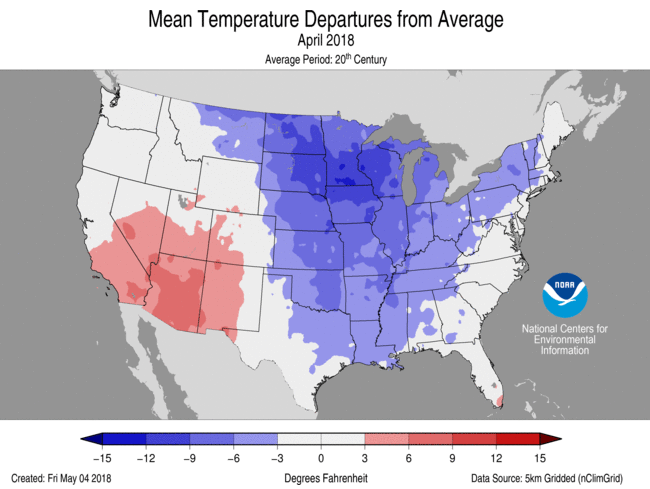 April Average Temperature Departures |
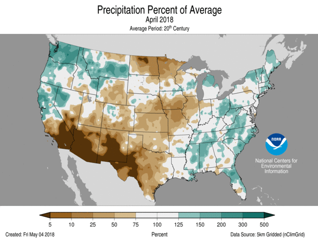 April Percent of Average Precipitation |
Temperature
- During April, the average contiguous U.S. temperature was 48.9°F, 2.2°F below the 20th century average, making it the 13th coldest April on record and the coldest since 1997.
- Below-average temperatures were observed from the Rockies to the East Coast. Twenty-two states had an April temperature that ranked among the 10 coldest on record. Eight states had their second coldest April on record and two states—Iowa and Wisconsin—were record cold.
- Above-average April temperatures were observed across much of the West, with record warm temperatures for parts of the Southwest. Arizona had its second warmest April on record with a statewide temperature 6.3°F above average. Above-average April temperatures were also observed in southern Florida.
- The contiguous U.S. average maximum (daytime) temperature during April was 61.7°F, 1.7°F below the 20th century average, marking the 21st coolest value on record and coolest since 1997. Below-average maximum temperatures were observed from the Rockies to East Coast, with 19 states having a top 10 cold April maximum temperature. Iowa had a record cold April maximum temperature. The location of record and near-record cold maximum temperature coincided with record-setting April snowfall. Above-average conditions were observed in the Southwest, where Arizona had its second warmest April maximum temperature on record.
- Nationally, the April minimum (nighttime) temperature was the seventh coldest on record at 36.1°F, 2.6°F below average. Below-average conditions were observed from the Rockies to the East Coast, where nine states had an average minimum temperature for the month that was record cold with fourteen additional states having much-below-average minimum temperatures. Above-average minimum temperatures were observed across the West.
- The Alaska average April temperature was 26.6°F, 3.3°F above the long-term mean. This ranked among the warmest third of the historical record. St. Paul and Cold Bay each had their fifth warmest April on record. Along the state’s west coast, sea ice continued to be much below average, contributing to the above-average temperatures. Some impacts of the low sea ice reported include coastal erosion and loss of hunting/fishing grounds.
- During April there were 7,068 record cold daily high (3,778) and low (3,290) temperature records, which was about 2.8 times the 2,563 record warm daily high (972) and low (1,591) temperature records.
- Based on NOAA's Residential Energy Demand Temperature Index (REDTI), the contiguous U.S. temperature-related energy demand during April was 82 percent above average and was the fifth highest value in the 124-year period of record. The below-average temperatures in the Northeast and Midwest contributed to the above-average REDTI.
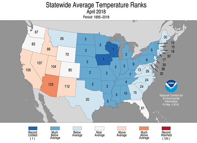
April 2018 Statewide Temperature Ranks
Precipitation

April 2018 Statewide Precipitation Ranks
- The April precipitation total for the contiguous U.S. was 2.41 inches, 0.11 inch below average, and ranked near the median value in the 124-year period of record.
- During April, above-average precipitation was observed along the West Coast, Northern Rockies and much of the East. Record high precipitation was observed in parts of the Northwest, with Washington state having its third wettest April on record with 5.53 inches of precipitation, 2.70 inches above average. This was the wettest April for the state since 1996.
- Below-average precipitation stretched from the Southwest, through much of the Great Plains, where five states had a monthly precipitation total that was much below average. The dry conditions in the Southern Plains provided ideal wildfire conditions with numerous large wildfires burning during the month. Record-low precipitation was observed in parts of the Southwest and mid-Mississippi Valley.
- According to NOAA data, analyzed by the Rutgers Global Snow Lab, the contiguous U.S. snow cover extent during April was 508,000 square miles, 227,000 square miles above the 1981–2010 average. This was the fifth largest April snow cover extent on record for the Lower 48 since satellite records began 52 years ago, and the largest April snow cover extent since 1997. Above-average snow cover was observed for most northern locations in the nation, with below-average snow cover in the Southwest.
- Most locations on the Hawaiian Islands had above-average precipitation during April with Lihue having its sixth wettest April and Kula its third wettest. On April 14-15, heavy rain fell across Kauai causing major flooding and landslides. According to preliminary data, a rain gauge near Hanalei, on Kauai’s North Shore, reported 49.69 inches of rain in 24 hours, potentially a new national record. It is pending review by the National Climate Extremes Committee.
- According to the May 1 U.S. Drought Monitor report, 28.6 percent of the contiguous U.S. was in drought, down from 29.4 percent at the beginning of April. Drought conditions improved in California, the Northern Plains and the Southeast. Drought also improved in parts of the Alaskan panhandle. Drought conditions expanded and intensified in the Southwest and Central to Southern Plains. The percent area of the contiguous U.S. experiencing D4 – Exceptional Drought, the worst category, expanded to 2.2 percent, the highest since November 2016. D4 drought conditions stretched from the Southwest to Southern Plains.
- Climate Highlights — year-to-date (January-April)
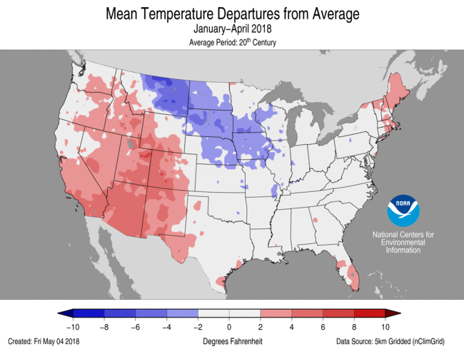 Jan-Apr Average Temperature Departures |
 Jan-Apr Percent of Average Precipitation |
Temperature
- The year-to-date (January–April) average contiguous U.S. temperature was 39.8°F, 0.7°F above average, ranking near the median value in the 124-year period of record. This was the coldest start to a year since 2014 for the nation.
- Above-average temperatures were observed across much of the West and parts of the East Coast. Arizona, California, New Mexico and Utah each had a January-April temperature that ranked among the 10 warmest on record with some locations in Arizona and New Mexico record warm. Below-average temperatures stretched from the Northern High Plains to the Mississippi Valley.
- The contiguous U.S. average maximum (daytime) temperature during January-April was 51.4°F, 0.9°F above the 20th century average, ranking in the warmest third of the historical record. Below-average maximum temperatures were observed in the Northern Plains, Midwest, and parts of the South. Above-average maximum temperatures were observed across the West and Southern Plains with much-above-average conditions in the Southwest.
- The contiguous U.S. January-April minimum (nighttime) temperature was 28.4°F, 0.5°F above average, and ranked near the median value. Above-average minimum temperatures were observed across the West and along parts of the East Coast. Below-average conditions were observed in the Great Plains and parts of the Midwest.
- The Alaska January–April temperature was 16.0°F, 5.7°F above the long-term average, tying the eighth warmest on record for the state. Record and near-record warm temperatures were observed across northern and western parts of the state with near-average conditions across southern Alaska and the panhandle. Utqia'vik (Barrow) had its warmest January–April on record, surpassing the previous record set in 2016 by 1.6°F.
- Based on NOAA's Residential Energy Demand Temperature Index (REDTI), the contiguous U.S. temperature-related energy demand during January-April was 11 percent below average and ranked near the median value in the 124-year period of record.

Jan-Apr Statewide Temperature Ranks
Precipitation
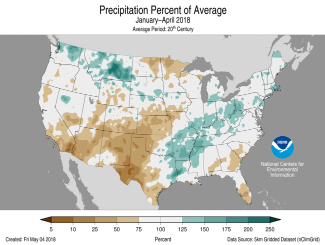
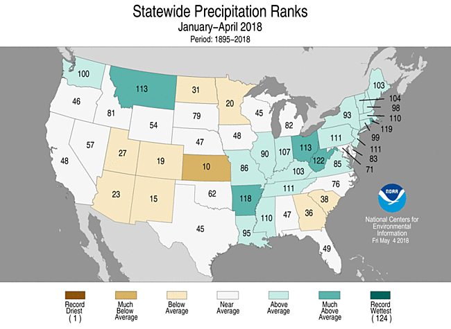
- The year-to-date precipitation total was 9.58 inches, 0.11 inch above average, also ranking near the median value.
- Below-average precipitation for the year-to-date was observed in the Southwest, the Southern High Plains and parts of the Central Plains and Upper Midwest. Kansas had its 10th driest year-to-date on record with a precipitation total 45 percent below average. Above-average precipitation was observed in parts of the Northwest, Northern High Plains, Lower Mississippi Valley and Ohio Valley. Arkansas, Montana, Ohio and West Virginia had year-to-date precipitation totals that were much above average.
Jan-Apr Statewide Precipitation Ranks
Extremes
- The U.S. Climate Extremes Index (USCEI) for the year-to-date was 15 percent below average and ranked near the median value in the 108-year period of record. Despite the below-average national value, there were elevated extremes in warm maximum temperatures and one-day precipitation totals. This was the lowest January-April CEI since 2013. The USCEI is an index that tracks extremes (falling in the upper or lower 10 percent of the record) in temperature, precipitation and drought across the contiguous United States.
- On the regional scale, the CEI in the Southwest ranked as the highest value on record due to extremes in warm maximum and minimum temperatures, the spatial extent of dry conditions and one-day precipitation totals.
**A comparison of the national temperature departure from average as calculated by NCDC's operational dataset (nClimDiv), the U.S. Historical Climatology Network (USHCN), and the U.S. Climate Reference Network (USCRN) is available on our National Temperature Index page.**
Regional Highlights:
These regional summaries were provided by the six Regional Climate Centers and reflect conditions in their respective regions. These six regions differ spatially from the nine climatic regions of the National Centers for Environmental Information.
- Northeast Region: (Information provided by the Northeast Regional Climate Center)
- The average April temperature in the Northeast was 41.2 degrees F (5.6 degrees C), which was 4.8 degrees F (2.7 degrees C) below normal, ranking this as the sixth coldest April on record for the region. Each state experienced colder than normal temperatures, with nine states ranking this April among their twenty coldest on record: New York, fifth coldest; Vermont and Pennsylvania, ninth coldest; Connecticut, 11th coldest, West Virginia and New Hampshire, 13th coldest; and Massachusetts, 15th coldest. Departures from normal ranged from 2.6 degrees F (1.4 degrees C) below normal in Delaware to 6.5 degrees F (3.6 degrees C) below normal in New York.
- The Northeast received 4.20 inches (106.7 mm) of precipitation, which was 115 percent of normal for the month of April. Delaware received 3.39 inches (86.1 mm) of precipitation, which was 93 percent of normal, causing that to be the only state in the region to experience drier than normal conditions this month. The other eleven states in the Northeast experienced wetter than normal conditions, with average precipitation amounts ranging from 3.69 inches (93.7 mm) in New York, to 5.37 inches (136.4 mm) in both Connecticut and Rhode Island. Vermont received 4.84 inches (122.9 mm) of precipitation this month, which was 127 percent of normal, ranking this as their 20th wettest April on record.
- Dry conditions have persisted in a small region of the Northeast during the month. Only 1 percent of the entire Northeast was experiencing abnormally dry conditions at the beginning of the month, increasing slightly to 2 percent of the region by the end of April. At the beginning of the month, 23 percent of Maryland was experiencing abnormally dry conditions and two percent of the state was under moderate drought. Abnormal dryness increased in Maryland throughout the month and by the end of April, 41 percent of the state was abnormally dry and one percent was in moderate drought.
- On April 2, a snowstorm moved through New Jersey, Pennsylvania and New York. The highest snow totals from this storm were areas near Scranton and Tobyhanna, Pennsylvania where 9 inches of snow (22.9 cm) were recorded. In Central Park, New York, 5.5 inches (14.0 cm) fell, despite temperatures having reached 60 degrees F (15.6 degrees C) the day before. This snowfall event ranked as the biggest snowstorm in New York City since 1982, as well as the seventh largest April snowstorm for the area on record. Some schools were closed or had delayed openings and over 300 flights in the New York City area were cancelled and many more were delayed. On April 4, strong winds brought down trees, power lines and cause travel disruptions across much of the Northeast. Across New York, gusts up to 75 miles per hour (33.5 m/s) were reported near Rochester, New York. High winds caused several tractor-trailers to rollover on Interstate 390, later prompting a commercial travel ban prohibiting high-profile vehicles from county roads that was in effect until that evening. Areas near Burlington, Vermont reported wind gusts up to 63 miles per hour (28.2 m/s) that day. Melting snow and recent rainfall led to a mudslide on April 5, which closed part of Route 30 in East Pittsburgh, Pennsylvania. An apartment complex was heavily damaged by the mudslide, but no injuries were reported. Colder than normal temperatures led Concord, New Hampshire to set their latest high temperature of 32 degrees F (0 degrees C) or colder on April 15. A day later on April 16, heavy rain caused flash flooding at several subway stations in New York City. Along the coast that same day, heavy rain and wind gusts up to 53 miles per hour (23.7 m/s) were recorded in Massachusetts, which created unfavorable conditions for participants of the Boston Marathon. A person was rescued from a vehicle after driving into floodwaters on a road along the Hawlings River in Maryland on April 17 after heavy rain led to flash flooding.
- For more information, please go to the Northeast Regional Climate Center Home Page.
- Midwest Region: (Information provided by the Midwest Regional Climate Center)
- Temperatures were well below normal in April. The region as a whole ranked as the 2nd coldest April since 1895, with only 1907 being colder. Statewide temperatures in Iowa, Minnesota, and Wisconsin were more than 10 degrees F (5.6 C) below normal and the other six states were 5 to 9 degrees F (2.8 to 5.0 C) below normal. Iowa and Wisconsin set new statewide records while Minnesota, Illinois, Missouri, and Michigan ranked as the 2nd coldest, Indiana ranked 3rd, Kentucky 7th, and Ohio 9th. Monthly temperatures were records at 373 stations across all nine Midwest states, including 82 stations in Iowa and 79 stations in Wisconsin. Daily record low temperatures (more than 3150) vastly outnumbered record highs (fewer than 100) during the month.
- April precipitation was generally below normal in the western half of the region and near or above normal in the eastern half. Precipitation deficits in northern Missouri and southern Iowa were as much as 3.00 inches (76 mm) below normal, or less than 25 percent of normal. Small areas in Ohio, Michigan, and northeastern Wisconsin had 150 percent of normal precipitation.
- April snowfall was above normal for most of the Midwest with more than half of the region receiving at least twice its normal monthly snowfall and many areas receiving several times normal. Totals topped 30 inches (76 cm) at stations in Iowa, Minnesota, Wisconsin, and Michigan. A wide swath from northern Iowa and southern Minnesota eastward to northern Michigan had snowfall totals at least 12 inches (30 cm) above normal. Many stations in this area, along with some further south, set new April snowfall records including more than 50 in Wisconsin and 20 or more in each of Iowa, Minnesota, and Michigan. Daily snow records were set across the Midwest on more than 900 occasions including more than 250 in Wisconsin alone. Green Bay set a new April snowfall record with 36.7 inches (93 cm), which also ranked as the 2nd snowiest month since records began in 1895. Only December 2008 with 45.6 inches (116 cm) was a snowier month in its 123-year history.
- Minnesota lakes were behind average in thawing out this spring. Lakes in southern Minnesota were as much as a month behind average while in central and northern parts of the state were about 2 weeks behind average. Many large lakes in northern Minnesota had yet to thaw as April came to an end.
- The month had less severe weather than in a typical Midwest April. There were reports of severe convective weather on just seven days, including only two with more than a handful of reports. The 3rd saw widespread reports across the southeastern third of the region. There were tornado reports in five states (Missouri, Illinois, Indiana, Ohio, and Kentucky), with those same states also reporting large hail and damaging winds. The 13th had reports of severe weather track across the five states in the western half of the region, including tornado reports in southern Missouri. A handful of severe weather reports came in on each of the 1st, 2nd, 15th, 17th, and 27th.
- Cold and snowy conditions, especially in early April, led to a slow start in spring planting. Corn planting was running about 2 weeks behind the 5-year average. Drier and more seasonal temperatures late in the month allowed planting to pick up though it remained behind normal.
- Drought expanded slightly in April. Small areas of northern Minnesota, southern Iowa, and northern Missouri were in moderate drought at the beginning of April. The area of moderate drought along the Iowa-Missouri border expanded by the end of the month increasing the percentage of the Midwest in drought from 2 percent to 4 percent. Areas of the region classified as abnormally dry, but not in drought, decreased during the month, particularly in Wisconsin. The abnormally dry percentage dropped from just over 10 percent of the Midwest to under 6 percent in April.
- For further details on the weather and climate events in the Midwest, see the weekly and monthly reports at the Midwest Climate Watch page.
- Southeast Region: (Information provided by the Southeast Regional Climate Center)
- Temperatures ranged from well below average to average across much of the Southeast region during April, but above-average temperatures were observed in central and southern Florida. Monthly mean temperatures were at least 2 degrees F (1.1 degrees C) below average for approximately 60 percent of the 155 long-term (i.e., period of record equaling or exceeding 50 years) stations in Alabama, Georgia, the Carolinas, Virginia, and Washington, D.C. A total of 39 long-term stations observed monthly mean temperatures that were ranked within their five coldest values on record, including Fairhope 2 NE, AL (1918-2018; coldest on record), Camilla 3 SE, GA (1938-2018; coldest on record), Walterboro 1 SW, SC (1904-2018; coldest on record), Covington Filtration Plant, VA (1961-2018; coldest on record), and New Bern, NC (1949-2018; second coldest). Several long-term stations across the region observed or tied their highest count of April days with a minimum temperature below 40 degrees F (4.4 degrees C), including Marshall, NC (1899-2018; 24 days), Mount Airy 2 W, NC (1893-2018; 20 days), Walhalla, SC (1897-2018; 16 days), Newnan 7 WNW, GA (1902-2018; 15 days), and Sylacauga 4 NE, AL (1955-2018; 15 days). On the 7th and 9th, multiple long-term stations in Virginia observed daily maximum temperatures that were ranked within their three lowest values on record for April, including Wise 1 SE (1956-2018; 31 degrees F, -0.6 degrees C), Charlottesville 2 W (1894-2018; 36 degrees F, 2.2 degrees C), Luray 5 E (1941-2018; 37 degrees F, 2.8 degrees C), and Covington Filtration Plant (38 degrees F, 3.3 degrees C). The coldest weather of the month across the Southeast occurred on the 17th, as the circulation around a departing mid-latitude cyclone ushered in unseasonably cold, dry air from Canada. Daily minimum temperatures fell below 35 degrees F (1.7 degrees C) across portions of every state north of Florida, with much of the Florida Peninsula reaching 55 degrees F (12.8 degrees C) or lower. In contrast, the warmest weather of the month occurred on the 13th and 14th, as the circulation around the Bermuda High, situated off the Atlantic coast, transported warm, humid air over the Southeast. Daily maximum temperatures exceeded 80 degrees F (26.7 degrees C) across much of the region, with portions of central and southern Florida reaching 90 degrees F or higher.
- Precipitation was near normal to well above normal across much of the Southeast region during April. Monthly precipitation totals ranged from 150 to more than 300 percent of normal in broad portions of every state and northwestern Puerto Rico. However, only 11 long-term stations observed April precipitation totals that were ranked within their five highest values on record, including Coloso, PR (1905-2018; 13.07 inches, 332 mm), Moulton, AL (1957-2018; 10.63 inches, 270 mm), Banner Elk, NC (1908-2018; 8.70 inches, 221 mm), and Florence Regional Airport, SC (1948-2018; 5.90 inches, 150 mm). Unusual dryness was found across portions of southwestern Florida and the U.S. Virgin Islands, where monthly precipitation totals were 50 to as low as 25 percent of normal. From the 7th through the 10th, a series of weak low pressure systems produced snowfall, which is unusual for April, across portions of North Carolina and Virginia, with total accumulations ranging from a trace to 5 inches (127 mm). Danville, VA (1946-2018) and Charlotte, NC (1879-2018) recorded a trace of snowfall for the first time during the month of April since 1982 and 1987, respectively. Appomattox, VA (1943-2018) observed its second, third, and fifth greatest 1-day snowfalls on record for April, with accumulations of 1.0 inch (25.4 mm) on the 8th, 0.9 inches (22.9 mm) on the 9th, and 0.2 inches (5.1 mm) on the 10th. Several other long-term stations in west-central Virginia observed 1-day snowfall totals that were ranked within their five highest values on record for April, including Lexington (1893-2018; 2.2 inches, 55.9 mm), Covington Filtration Plant (1961-2018; 1.0 inch), Concord 4 SSW (1951-2018; 0.5 inches, 12.7 mm), Buckingham (1896-2018; 0.5 inches), and Pedlar Dam (1943-2018; 0.5 inches). On the 9th and 10th, a stalled front generated heavy rainfall across portions of northern and central Florida. Numerous CoCoRaHS stations recorded 24-hour precipitation totals exceeding 5 inches, including 7.20 inches (183 mm) near Orange Springs, 6.86 inches (174 mm) near Micanopy, and 6.35 inches (161 mm) near Bronson. On the 9th, Gainesville, FL (1897-2018) observed its wettest day on record for April and meteorological spring (March-May), with 4.95 inches (126 mm) of precipitation. On the 10th, Crescent City, FL (1912-2018) observed its second wettest April day on record and its sixth wettest day during meteorological spring, with 3.80 inches (96.5 mm) of precipitation. From the 14th through the 16th, a strong and slow-moving mid-latitude cyclone produced 1 to more than 5 inches of rainfall across much of the region, with reports of localized flooding in several states. Five long-term stations observed their wettest April day on record, including Chatom, AL (1950-2018; 7.10 inches, 180 mm), Jackson, AL (1962-2018; 6.06 inches, 154 mm), Lake City 2 SE, SC (1938-2018; 3.57 inches, 90.7 mm), Staffordsville 3 ENE, VA (1952-2018; 2.81 inches, 71.4 mm), and Quantico MCAS, VA (1945-2018; 2.42 inches, 61.5 mm). In addition, multiple long-term stations in Alabama, the Carolinas, and Virginia observed their second or third wettest April day on record, including Huntsville, AL (1894-2018; 3.77 inches, 95.8 mm), Hot Springs, VA (1893-2018; 3.50 inches, 88.9 mm), Raleigh, NC (1887-2018; 3.31 inches, 84.1 mm), and Laurens, SC (1902-2018; 2.98 inches, 75.7 mm). Numerous submerged vehicles and flooded homes were reported in the community of Fulton in southwestern Alabama, requiring at least 18 water rescues. From the 22nd through the 24th, a slow-moving low pressure system produced 2 to more than 5 inches (50.8 to more than 127 mm) of rainfall across portions of every state in the region. Several long-term stations observed 1-day precipitation totals that were ranked within their three highest values on record for April, including Atlanta, GA (1879-2018; 4.16 inches, 106 mm), Boone, NC (1929-2018; 3.94 inches, 100 mm), Jasper, AL (1961-2018; 3.87 inches, 98.3 mm), Marion, NC (1893-2018; 3.81 inches, 96.8 mm), New River MCAF, NC (1964-2018; 3.76 inches, 95.5 mm), and Morganton, NC (1893-2018; 3.34 inches, 84.8 mm). In western North Carolina, four long-term stations observed their highest 2-day precipitation totals on record for April, including Marion (5.21 inches, 132 mm), Jefferson 2 E (1896-2018; 4.73 inches, 120 mm), Morganton (4.51 inches, 115 mm), and Hickory Regional Airport (1949-2018; 3.81 inches).
- There were 360 severe weather reports across the Southeast during April, which is over 140 percent of the median monthly frequency of 253 reports during 2000-2017. At least one severe weather report was recorded on 11 days during the month, but over 60 percent (221 of 360) of the reports occurred during a severe weather outbreak on the 15th. Nearly 90 percent (311 of 360) of the severe weather reports during the month were for strong thunderstorm winds. On the 3rd, a vigorous squall line produced straight-line wind gusts exceeding 50 mph across portions of northern Alabama, with some of the highest recorded gusts including 72 mph at Pryor Field Regional Airport near Decatur, 70 mph at Huntsville International Airport, and 62 mph at Northwest Alabama Regional Airport in Muscle Shoals. The Riverwalk Marina and approximately 20 large boats were damaged in Decatur, while downed trees and power lines caused damage to vehicles, homes, and other structures across northern Alabama, resulting in at least 1 injury. On the 15th, severe thunderstorms produced wind gusts exceeding 60 mph at several locations across the region, including 74 mph at Columbia Metropolitan Airport, SC, 67 mph at Charlotte Douglas International Airport, NC, 64 mph at Venice Municipal Airport, FL, and 62 mph at Vero Beach Regional Airport, FL. There were numerous reports of trees falling onto homes and vehicles, which resulted in 1 fatality and at least 7 injuries in Florida and the Carolinas. Three reports of large hail were recorded during the month, including 3-inch (tea cup-sized) hail in St. Johns County, FL on the 10th and 2.75-inch (baseball-sized) hail in Gaston County, NC on the 15th. A total of 31 tornadoes (1 unrated, 14 EF-0s, 13 EF-1s, 2 EF-2s, 1 EF-3) were confirmed across the region, which is slightly higher than the median frequency of 27 tornadoes observed during April. At least 27 injuries were caused by tornadoes during the month. On the 15th, an EF-2 tornado tracked over 33 miles across Guilford and Rockingham Counties in north-central North Carolina, resulting in at least 10 injuries. Shortly after touching down on the southeast side of Greensboro, the tornado produced extensive damage in the community of Hampton, where numerous homes lost much of their roofing and several residences had exterior walls blown out. In addition, a large portion of the roof at Hampton Elementary School was blown off, while three portable classrooms were completely destroyed. Over 1,000 structures in Guilford County sustained some degree of damage, with nearly 200 of these structures suffering major damage or complete destruction. While the tornado did not directly cause any fatalities, strong straight-line winds on the periphery of the tornadic circulation blew a tree onto a moving vehicle in Greensboro, killing the driver. Just over an hour later, the same thunderstorm produced an EF-3 tornado that tracked across portions of three counties in central Virginia, including the western portion of Lynchburg. Many hundreds of trees were snapped or uprooted, and dozens of homes sustained major damage or destruction along its 25.8-mile path, with at least 12 reported injuries. On the 7th, a lightning strike killed a 23-year-old woman and injured four other people in White Springs, FL. They were reportedly sheltering under a vehicle trailer when lightning struck a tree that was located about 25 to 30 feet away.
- Significant drought improvement occurred across much of the Southeast during the month, as above-normal precipitation reduced the coverage of moderate-to-severe (D1-D2) drought conditions from 26 percent on April 3rd to 14 percent on May 1st. Moderate drought was eliminated from the District of Columbia and was almost completely removed from Alabama. The greatest drought improvement occurred in South Carolina and Georgia, where the coverage of moderate-to-severe drought fell 27 and 23 percentage points, respectively. By the end of the month, severe drought was eliminated from South Carolina and covered only a small portion of southeastern Georgia. In contrast, severe drought developed and expanded across portions of southern Florida due to persistent dryness during the month. Cooler-than-normal air and soil temperatures, coupled with frequent rainfall in some areas, continued to delay the planting and early growth of row crops (e.g., corn, cotton, peanuts, soybeans, and tobacco) across much of the region. While above-average temperatures and much-needed rainfall improved pasture conditions across the Florida Peninsula, persistent coolness slowed the growth and green-up of livestock pastures in other parts of the region. Overgrazed pastures were reported in northern and southwestern Virginia, with livestock producers having to provide unusually large supplemental feedings for this late into the growing season. Agricultural producers in parts of Alabama, Georgia, and North Carolina struggled to spray their fields with weed-controlling herbicides due to persistent windiness during the month. In addition, high winds in mid-April delayed the transplanting of tobacco in coastal South Carolina and caused significant damage to sensitive vegetable crops in southwestern Georgia. Periods of frost and sub-freezing temperatures during the month caused minor damage to a variety of blooming fruit crops in western North Carolina and northern Virginia, including peaches, apples, cherries, and nectarines. However, a much greater-than-normal yield of peaches is expected in Georgia and South Carolina due to minimal losses from spring freezes and a sufficient accumulation of chill hours during the winter.
- For more information, please go to the Southeast Regional Climate Center Home Page.
- High Plains Region: (Information provided by the High Plains Regional Climate Center )
- April brought a wide variety of hazards to the High Plains, including record cold, blizzards, wildfires, and dust storms. Below-normal temperatures dominated eastern areas of the region this month, with departures exceeding 8.0 degrees F (4.4 degrees C) below normal across portions of the Dakotas. Numerous daily records for lowest maximum and minimum temperatures were broken during the first two weeks of April, and for many locations, it was the coolest first half of April (April 1-15) on record. Late-season snowstorms impacted much of the region, particularly in mid-April when a blizzard produced record snowfall totals and caused whiteout conditions, severe travel disruptions, and power outages. The cold and wet conditions negatively impacted calving and lambing, especially in South Dakota, and losses are still being determined. Additionally, planting was delayed across the Northern and Central Plains as soils were slow to warm up.
- Despite the impressive snowfall totals, April precipitation was below normal in most locations. While heavy snows improved drought conditions across the Northern Plains, drought continued to spread and intensify throughout Colorado and Kansas where precipitation deficits have been accumulating since October. Wildfires burned across these states, as well as others in the Southern Plains where historically extreme fire conditions were present. One notable fire in the High Plains region was the Badger Hole Fire, which burned over 48,000 acres on the border between southeastern Colorado and western Kansas, killing livestock, destroying homes, and causing $250,000 in damage to electrical infrastructure. The combination of high winds, dryness, and freshly tilled soils prompted the National Weather Service in Omaha to issue a Dust Storm Warning for eastern Nebraska, which is highly unusual for the area. Several multi-vehicle crashes occurred on Interstate 80 due to blowing dust and reduced visibility. Cold temperatures and dry conditions caused a late start to the severe weather season across the Central and Southern Plains. No tornadoes were reported in Kansas in April, which was the latest start to the tornado season since 2000.
- Despite the impressive snowfall totals, April precipitation was below normal in most locations. While heavy snows improved drought conditions across the Northern Plains, drought continued to spread and intensify throughout Colorado and Kansas where precipitation deficits have been accumulating since October. Wildfires burned across these states, as well as others in the Southern Plains where historically extreme fire conditions were present. One notable fire in the High Plains region was the Badger Hole Fire, which burned over 48,000 acres on the border between southeastern Colorado and western Kansas, killing livestock, destroying homes, and causing $250,000 in damage to electrical infrastructure. The combination of high winds, dryness, and freshly tilled soils prompted the National Weather Service in Omaha to issue a Dust Storm Warning for eastern Nebraska, which is highly unusual for the area. Several multi-vehicle crashes occurred on Interstate 80 due to blowing dust and reduced visibility. Cold temperatures and dry conditions caused a late start to the severe weather season across the Central and Southern Plains. No tornadoes were reported in Kansas in April, which was the latest start to the tornado season since 2000.
- Temperatures during the first half of the month (April 1-15) were especially cool in the High Plains, ranging from about 11.0-17.0 degrees F (6.1-9.4 degrees C) below normal. Many locations had their coolest first half of April on record. A cold snap that occurred during the first week of the month set records for lowest April temperature at Aberdeen, South Dakota, Pierre, South Dakota, and Concordia, Kansas. On the 4th, it got down to -6.0 degrees F (-21.1 degrees C) in Aberdeen, which was not only its lowest April temperature on record, but it was also the latest date that a negative temperature was recorded for Aberdeen. Aberdeen ended up recording four of the top 10 lowest minimum temperatures that have occurred in the month of April.
- Thankfully, it is unlikely that crops or other plants were damaged by the cold temperatures in April because the cold spell did not follow a period of warm weather. In previous years, spring came early and plants broke dormancy prematurely, and a cold spell like the one experienced during April would have been detrimental to plants. However, the cold temperatures are largely responsible for a delay in spring planting this year, particularly across the Dakotas. For instance, as of the end of April, the planting of spring wheat, oats, barley, and sugar beets had barely begun.
- It was a dry month for the High Plains, as precipitation ranged from 50-70 percent of normal across a large portion of the region. The driest areas included much of North Dakota and eastern Nebraska where less than 25 percent of normal precipitation fell. For instance, Omaha, Nebraska had its 3rd driest April on record, receiving only 0.27 inches (7 mm) of precipitation, which was 9 percent of normal. Locations in North Dakota, Kansas, and Wyoming had Aprils that ranked in the top 10 driest as well. Precipitation deficits tend to accumulate quickly during the spring season and should be watched as we head into the late spring and summer, which is typically the wettest time of year.
- It was a dry month for the High Plains, as precipitation ranged from 50-70 percent of normal across a large portion of the region. The driest areas included much of North Dakota and eastern Nebraska where less than 25 percent of normal precipitation fell. For instance, Omaha, Nebraska had its 3rd driest April on record, receiving only 0.27 inches (7 mm) of precipitation, which was 9 percent of normal. Locations in North Dakota, Kansas, and Wyoming had Aprils that ranked in the top 10 driest as well. Precipitation deficits tend to accumulate quickly during the spring season and should be watched as we head into the late spring and summer, which is typically the wettest time of year.
- Despite much of the High Plains being drier than normal, several snowstorms impacted the region, setting snowfall records for the month of April. The most notable storm was a blizzard that occurred April 13th-15th, impacting the North-Central U.S. For some locations, this storm produced the highest snowfall totals of the season. For instance, Sioux Falls, South Dakota received 14.5 inches (37 cm) of snow from the storm, which was the largest snowstorm of the season. It was by far the snowiest April on record for Sioux Falls, as an astounding 31.4 inches (80 cm) of snow fell, crushing the old record of 18.4 inches (47 cm) set in 1983. It was also Sioux Falls' 4th snowiest month on record! Blizzard conditions significantly reduced visibility across the region, and long stretches of highways and Interstates 29, 70, 80, and 90 were closed, impacting travel in Colorado, Kansas, Nebraska, South Dakota, and Wyoming. Numerous power outages occurred, and a combination of ice and high winds took down the Region 26 Emergency Management Agency tower in Ord, Nebraska that supported local law enforcement, first responders, and the NOAA weather transmitter. This excessive snowfall, followed by a rapid warmup, caused flooding along the Big Sioux River and Little Sioux River in eastern South Dakota.
- Upper Missouri Basin snowpack continued to be well above normal during April. According to the U.S. Army Corps of Engineers, Snow Water Equivalent (SWE) above Fort Peck Reservoir was 135 percent of average as of the end of April, and SWE between Fort Peck and Garrison Reservoirs was 129 percent of average. It appears that the snowpack has peaked in both reaches near the normal peak date of April 15. Cool and wet conditions across northwestern Wyoming allowed mountain snowpack to remain above normal. As for Colorado snowpack, the San Juan and Sangre de Cristo Mountains experienced a near-record-low snowpack this season and are on track for a near-record early meltout, according to the Colorado Climate Center. In the Plains, the mid-April storm blanketed the Dakotas, Nebraska, northern Kansas, and northeastern Colorado with snow, but the region was snow free by the end of the month.
- Drought conditions improved in the Dakotas but worsened in parts of Colorado and Kansas during April. A late-spring winter storm brought record-breaking snowfall to portions of the Northern Plains, which alleviated drought conditions. According to the U.S. Drought Monitor, the area experiencing drought decreased from 49 percent to 39 percent in North Dakota, and from 36 percent to 19 percent in South Dakota. The area in severe drought (D2) was removed, while moderate drought (D1) and abnormally dry (D0) conditions were vastly reduced. According to the South Dakota State Climatologist, stock ponds have filled up from snowmelt, and this April moisture bodes well for grasses and forage production later in the season.
- It was another dry month for drought-stricken areas of Colorado and Kansas, causing conditions to worsen. Storms brought some relief to northern Colorado, while southern Colorado and much of Kansas remained dry. Exceptional drought (D4) was expanded in southern Kansas and introduced to southwestern Colorado. Extreme drought (D3) expanded to encompass all of southern Colorado, and D3 conditions reached into central Kansas as well. As for impacts, below-normal runoff is expected in western Colorado due to the lack of snow this season. The primary agricultural impacts to the Southern Plains have been on cattle, hay, and winter wheat. Unprecedented fire conditions were present across portions of Colorado, Kansas, New Mexico, Oklahoma, and Texas, and high winds caused fires to spread quickly, burning thousands of acres.
- For more information, please go to the High Plains Regional Climate Center Home Page.
- Southern Region: (Information provided by the Southern Regional Climate Center)
- April temperatures were below normal throughout most of the Southern Region. Western Tennessee, north and central Arkansas, central and northeastern Oklahoma, and an area in central Texas experienced temperatures 6 to 8 degrees F (3.33 to 4.44 degrees C) below normal. Most of Arkansas and Oklahoma, central and western Tennessee, northern, central, and southeast Mississippi, central and southern Louisiana, and northeastern Texas were 4 to 6 degrees F (2.22 to 3.33 degrees C) below normal. The only area above normal for April was western Texas which experienced 2 to 6 degrees F (1.11 to 3.33 degrees C) above normal temperatures. The statewide monthly average temperatures were as follows: Arkansas–55.10 degrees F (12.83 degrees C), Louisiana–62.40 degrees F (16.89 degrees C), Mississippi–59.10 degrees F (15.06 degrees C), Oklahoma–53.80 degrees F (12.11 degrees C), Tennessee–52.80 degrees F (11.56 degrees C), and Texas–62.90 degrees F (17.17 degrees C). The statewide temperature rankings for April were as follows: Arkansas (third coldest), Louisiana (fifth coldest), Mississippi (third coldest), Oklahoma (second coldest), Tennessee (fourth coldest), and Texas (twentieth coldest). All state rankings are based on the period spanning 1895-2018.
- Precipitation values for the month of April varied spatially throughout the Southern Region. Parts of southeastern Mississippi and extreme eastern Tennessee received 200–300 percent of normal precipitation. Central and eastern Tennessee, southeastern Arkansas, southeastern Louisiana, and parts of southern, central, and northwestern Mississippi received 150–200 percent of normal precipitation. In contrast, parts of northern, central, and western Texas received 5 percent or less of normal precipitation. Areas of northern, western, central, and southern Texas, southwest and northeastern Oklahoma, and north and northwestern Arkansas received 50 percent or less of normal precipitation. The state-wide precipitation totals for the month were as follows: Arkansas–4.89 inches (124.21 mm), Louisiana–4.92 inches (124.97 mm), Mississippi–6.80 inches (172.72 mm), Oklahoma–2.07 inches (52.58 mm), Tennessee–5.76 inches (146.30 mm), and Texas–1.02 inches (25.91 mm). The state precipitation rankings for the month were as follows: Arkansas (fifty-eighth wettest), Louisiana (fifty-fifth wettest), Mississippi (thirty-third wettest), Oklahoma (twenty-second driest), Tennessee (twenty-sixth wettest), and Texas (fourteenth driest). All state rankings are based on the period spanning 1895-2018.
- In April, the exceptional drought classification expanded in western Oklahoma and northern Texas. Extreme drought classification appeared in southwest Texas. The severe drought classification remained through parts of north-central Oklahoma, and central, northern and western Texas. The moderate drought classification remains throughout parts of western, central, northern, and southeast Texas. Drought conditions improved from moderate to abnormally dry conditions in southern Texas. There are currently no drought conditions in Arkansas, Louisiana, Mississippi, and Tennessee.
- In April, there were 11 days with severe weather reports throughout the region. There were 696 severe weather events (75 tornado, 203 hail, and 418 wind) reported throughout the Southern Region. Forty-two of the tornado events and 116 of the wind events occurred throughout Texas, Louisiana, Arkansas, Tennessee, and Mississippi on April 13. On April 6, there were 19 tornado events reported throughout Texas, Louisiana, and Mississippi.
- As of the end of April, Oklahoma had not had a tornado touchdown in 2018. That broke the record for the longest streak to start a calendar year without a tornado in Oklahoma in recorded history.
- On April 3, 2018, there were 59 hail and 181 wind events reported throughout Oklahoma, Texas, Louisiana, Arkansas, and Mississippi. A downburst from a thunderstorm with a wind gust of 90 mph (144.84 kph) caused many downed trees in Mangham, Louisiana. Another strong wind gust of 80 mph (128.75 kph) was reported in East Haven, Texas.
- On April 6, 2018, 19 tornado reports were received throughout Texas, Louisiana, and Mississippi. In Coushatta, Louisiana an EF-2 tornado occurred causing significant tree damage. Hail caused significant vehicle damage in Celina, Texas. A wind gust of 60 mph (96.56 kph) was reported in Mount Pleasant, Texas.
- On April 13, 2018, 42 tornado reports were received throughout Arkansas, Mississippi, Texas, and Louisiana. A tornado near Shreveport, Louisiana caused one death when it touched down around highway 3132 and caused considerable tree damage. A wind gust of 70 mph (112.65 kph) was reported in Grand Lake, Arkansas.
- On April 14, 2018, 14 tornado reports were received throughout Mississippi and Louisiana. A tornado caused two injuries in Meridian, Mississippi. In Poplarville, Mississippi, roofs were blown off businesses due to strong winds.
- On April 29, 2018, a 59 mph (94.95 kph) wind gust was reported in Dimmitt, Texas.
- For more information, please go to the Southern Regional Climate Center Home Page.
- Western Region: (Information provided by the Western Region Climate Center)
- A few storm systems impacted the West this month bringing well above normal precipitation to portions of the Northwest, western Great Basin, and Intermountain West. Little to no precipitation was observed along the southern tier of the region. Temperatures were above normal throughout the Southwest and cooler than normal across the northern tier of the region.
- The first half of the month brought active weather to northern California and the Pacific Northwest. During the 4th-7th, a very strong atmospheric river made landfall on the West Coast. Weather balloons released at Oakland, California, recorded the highest precipitable water amounts for any month, November-May. This storm produced much of the month's precipitation at many locations. San Francisco, California, recorded 3.91 in (99 mm), 268% of normal for the month. This was the 14th wettest April since records began in 1849. Across the Sierra Nevada, Mina, Nevada, reported its 10th wettest April on record at 1.6 in (41 mm), 216% of normal. Records for Mina began in 1896. Further north, Wenatchee, Washington, reported its 14th wettest April in an 88-year record at 1.10 in (28 mm), 208% of normal. By month's end, snowpack in the Pacific Northwest region stood at 115% of median. The Upper Colorado region reported 57% of median snowpack. In the Great Basin region, snowpack stood at 43% of normal. The Sierra Nevada was reporting 32% of normal snow water equivalent.
- Precipitation was well below normal across the southern tier of the region, with many locations receiving no measurable precipitation. Los Angeles reported 0.02 in (0.5 mm), just 2% of normal for April. This ranks as the 18th driest April in this station's 142-year record. Phoenix, Arizona, and Albuquerque, New Mexico, reported no measurable precipitation. Normal April precipitation is 0.28 in (7 mm) at Phoenix and 0.61 in (15 mm) at Albuquerque. There are 21 other years with no measurable April precipitation in Phoenix's 86-year record and 16 such years in Albuquerque's 128-year record. Due to dry conditions, above normal temperatures, and lack of snowpack, drought conditions degraded this month in many areas of the Southwest. Changes were most notable in southern Nevada, the Four Corners region, and in New Mexico. The percentage of extreme to exceptional drought conditions by area in the Four Corners states is: 48% of Arizona, 46% of New Mexico, 28% of Utah, and 31% of Colorado.
- Temperatures were well above normal across the Southwest, transitioning to cooler than normal in the northeastern portion of the region. In southeastern California, Bishop observed its 2nd warmest April on record with an average temperature of 59.1 F (15.1 C), 4.6 F (2.6 C) above normal. Records for Bishop began in 1895. Las Vegas, Nevada, logged its 2nd warmest April in a 71-year record at an average temperature of 72.5 F (22.5 C), 5.3 F (2.9 C) above normal; records began in 1948. In Arizona, temperatures in Phoenix averaged to 77.4 F (25.2 C), 4.7 F (2.6 C) above normal and the 3rd warmest in an 86-year record. In southern New Mexico, Las Cruces experienced its 4th warmest April since records began in 1892 at 65.5 F (18.6 C), 4.1 F (2.3 C) above normal. Temperatures were much cooler than normal across northern and central Montana. Great Falls reported an average April temperature of 38.4 F (3.6 C), 4.7 F (2.6 C) below normal.
- Temperatures were near normal across much of Alaska, though much warmer than normal in the western part of the state. Kotzebue reported an average April temperature of 21.3 F (-5.9 C), 8 F (4.4 C) above normal. This was the 12th warmest since records began in 1897. Precipitation was variable across the state, with drier than normal conditions dominating around the Fairbanks region and above normal observed in the southwestern portion of the state. Fairbanks measured 0.15 in (4 mm), 48% of normal. In contrast, King Salmon received 2.06 in (52 mm), 212% of normal and the 8th wettest April since records began in 1917. Further south, Hawaii experienced very active weather throughout the month. April precipitation totals were near to well above normal across the state. On Kauai, Lihue logged 5.7 in (145 mm) of precipitation, 253% of normal and the 6th wettest since records began in 1950. On Maui, Kula reported 5.38 in (137 mm), 361% of normal and the 3rd wettest in a 41-year record.
- Temperatures were near normal across much of Alaska, though much warmer than normal in the western part of the state. Kotzebue reported an average April temperature of 21.3 F (-5.9 C), 8 F (4.4 C) above normal. This was the 12th warmest since records began in 1897. Precipitation was variable across the state, with drier than normal conditions dominating around the Fairbanks region and above normal observed in the southwestern portion of the state. Fairbanks measured 0.15 in (4 mm), 48% of normal. In contrast, King Salmon received 2.06 in (52 mm), 212% of normal and the 8th wettest April since records began in 1917. Further south, Hawaii experienced very active weather throughout the month. April precipitation totals were near to well above normal across the state. On Kauai, Lihue logged 5.7 in (145 mm) of precipitation, 253% of normal and the 6th wettest since records began in 1950. On Maui, Kula reported 5.38 in (137 mm), 361% of normal and the 3rd wettest in a 41-year record.
- April (all month): Early fire season in Arizona: Dry winter and early spring conditions as well as above normal temperatures and high winds supported an early start to Arizona's primary fire season, which typically begins in late May. The Tinder Fire, roughly 100 mi (160 km) northeast of Phoenix, was ignited on April 27 and has burned over 8600 acres (3480 hectares) and destroyed structures; losses are being evaluated.
- Mid-to-late April: Snowmelt flooding in northern/central Montana: Following an, in some cases, record-breaking winter snowpack, Montana is facing spring snowmelt flooding. Floodwaters have washed out roads, inundated fields, and prompted evacuations from threatened homes. Farmers are concerned that flooding may delay planting of spring wheat. The Governor declared a flood emergency in seven counties.
- For more information, please go to the Western Regional Climate Center Home Page.