National Overview:

- Climate Highlights — May
 May Average Temperature Departures |
 May Percent of Average Precipitation |
Temperature
- The May average temperature for the contiguous U.S. was 60.6°F, 0.4°F above average, and ranked near the middle of the 123-year period of record.
- Above-average temperatures were observed along the West Coast and into the Great Basin and Northern Rockies as well as along the coastal Southeast. Below-average temperatures were observed in parts of the Great Plains, Upper Midwest, and Lower-Mississippi Valley. No state had a record warm or record cold May temperature.
- The contiguous U.S. average maximum (daytime) temperature during May was 73.3°F, 0.3°F above the 20th century average, and ranked near the middle of the historical record. In the East, Midwest, Central Plains and Lower Mississippi Valley above-average precipitation was associated with suppressed daytime maximum temperatures. Louisiana had its ninth coldest May maximum temperature on record and coldest since 2013. Above-average maximum temperatures were observed in the West, Northern Rockies and Plains and in Florida.
- The contiguous U.S. average minimum (nighttime) temperature during May was 47.8°F, 0.4°F above the 20th century average, also ranking near the middle of the historical record. Above-average minimum temperatures were observed in the Midwest and along the entire East Coast, as well as along the West Coast into the Great Basin and Northern Rockies. Below-average minimum temperatures were observed in the Central and Southern Plains and Lower Mississippi Valley.
- During May there were 3,381 record warm daily high (1,187) and low (2,194) temperature records, which was slightly more than the 3,007 record cold daily high (1,973) and low (1,034) temperature records.
- Based on NOAA's Residential Energy Demand Temperature Index (REDTI), the contiguous U.S. temperature-related energy demand during May was 15 percent below average and the 58th lowest value in the 123-year period of record. This was due to the mixed pattern of above- and below-normal temperatures and the time of year. Below-normal monthly temperatures in the Northeast increased heating demand. Below-normal monthly temperatures in the Southern Plains reduced cooling demand, but above-normal temperatures in parts of the Southeast increased cooling demand.

May 2017 Statewide Temperature Ranks
Precipitation
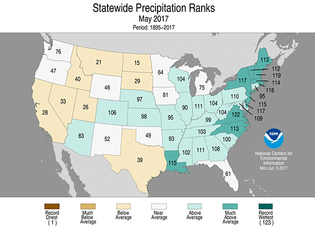
May 2017 Statewide Precipitation Ranks
- The May contiguous U.S. precipitation total was 3.31 inches, 0.40 inch above average, tying 2009 as the 25th wettest on record.
- Above-average precipitation fell across most of the East and parts of the Rockies and Great Plains. Areas along the East and Gulf Coasts were particularly wet, with 10 states much wetter than average. Below-average precipitation was observed in the West, Northern Plains and Rockies, southern Florida, and the Southern Plains.
- On the daily scale, there were 2,423 daily precipitation records broken or tied during May, 67 of which were the highest daily May totals on record.
- According to the May 30 U.S. Drought Monitor report, 5.3 percent of the contiguous U.S. was in drought, up 0.3 percent compared to the May 2 values. This continues the near-record low levels of drought that began in April. Drought improved across the Northeast, Mid-Atlantic and Southeast. Drought worsened in the Northern and Southern Plains as well as in central and northern Florida.
- Climate Highlights — spring (Mar-May)
 Mar-May Average Temperature Departures |
 Mar-May Percent of Average Precipitation |
Temperature
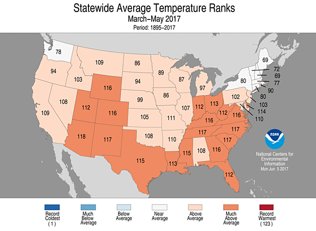
- The spring (March-May) average temperature for the contiguous U.S. was 53.5°F, 2.6°F above the 20th century average, driven in large part by warmth during the early and middle part of the season. This was the eighth warmest spring on record for the contiguous United States.
- Above-average temperatures spanned the nation during spring, with near-average temperatures observed in parts of the Northwest and Northeast. Nineteen states across the Rockies, Southern Plains, Southeast and Midwest had spring temperatures that were much above average. No state had a record warm or cold spring. For locations from the Rockies to East Coast, the majority of the seasonal warmth occurred during early- and mid-spring.
- The contiguous U.S. average maximum (daytime) temperature during spring was 65.6°F, 2.5°F above the 20th century average, and the 13th warmest on record. Above-average maximum temperatures were observed for much of the nation with much-above-average maximum temperatures in 10 states across the Southwest, Southern Plains, Ohio Valley, and Southeast. Below-average maximum temperatures were observed in the Northeast.
- The contiguous U.S. average minimum (nighttime) temperature during spring was 41.3°F, 2.7°F above the 20th century average, and the fourth warmest on record. Every state across the Lower 48 had above-average minimum temperatures with much-above-average minimum temperatures across the West, Southern Plains, Mid- to Lower-Mississippi Valley, Midwest and the Mid-Atlantic.
- Based on REDTI, the contiguous U.S. temperature-related energy demand during March-May was 54 percent below average and the 11th lowest value in the 123-year period of record.
Mar-May Statewide Temperature Ranks
Precipitation
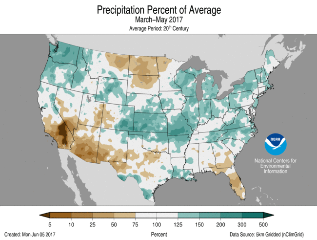
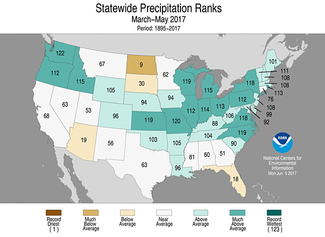
- The spring precipitation total was 9.39 inches, 1.45 inches above the 20th century average, marking the 11th wettest spring on record.
- Above-average precipitation was observed from coast to coast, with 15 states in the Northwest, Central Plains, Mid-Mississippi Valley, Great Lakes and Mid-Atlantic much wetter than average. No state had a spring precipitation total that was record wet. Below-average precipitation was observed in the Southwest, Northern Plains and Florida. North Dakota had its ninth driest spring on record. No state was record dry.
Mar-May Statewide Precipitation Ranks
Extremes
- The U.S. Climate Extremes Index (USCEI) for spring was above average and ranked as the 19th highest value on record. On the national scale, extremes in warm maximum and minimum temperatures, one-day precipitation totals, and days with precipitation were above average. The USCEI is an index that tracks extremes (falling in the upper or lower 10 percent of the record) in temperature, precipitation and drought across the contiguous U.S.
- On the regional scale, the CEI in the Southeast ranked as the ninth highest spring value on record due to extremes in warm maximum and minimum temperatures, the spatial extent of drought, and one-day precipitation totals.
- Climate Highlights — year-to-date (January-May)
 Jan-May Average Temperature Departures |
 Jan-May Percent of Average Precipitation |
Temperature
- The year-to-date average temperature for the contiguous U.S. was 47.0°F, 3.7°F above the 20th century average. This ranked as the second warmest January-May on record for the contiguous U.S. — 1.4°F cooler than the record set in 2012 and marginally warmer than the same period in 2000.
- Above-average temperatures spanned the nation with only parts of the Northwest being colder than average. Forty states were much warmer than average during January-May with Florida, Georgia, North Carolina, South Carolina and Texas record warm.
- The contiguous U.S. average maximum (daytime) temperature during January-May was 58.4°F, 3.4°F above the 20th century average, and the fifth warmest on record. Above-average maximum temperatures were observed for much of the nation, except parts of the Northwest where below-average maximum temperatures were observed. Record warm maximum temperatures were observed along the Southeast coast.
- The contiguous U.S. average minimum (nighttime) temperature during January-May was 35.7°F, 4.0°F above the 20th century average, and the second warmest on record, behind only 2012. Above-average minimum temperatures were observed from coast to coast with near-average minimum temperatures in the Northwest. Nine states in the Southwest and Southeast saw record warm year-to-date minimum temperatures.
- Based on REDTI, the contiguous U.S. temperature-related energy demand during January-May was 87 percent below average and the second lowest value in the 123-year period of record.
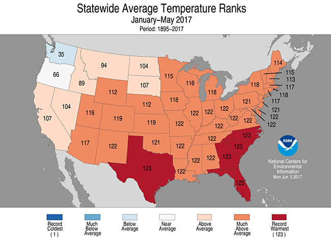
Jan-May Statewide Temperature Ranks
Precipitation
- The year-to-date precipitation total for the contiguous U.S. was 14.85 inches, 2.46 inches above average and the fourth wettest January-May on record for the Lower 48. This was the wettest first five months of a year since 1998.
- Above-average precipitation was widespread in the West where six states had much-above-average precipitation due to early year rain and snow. Idaho had its wettest year-to-date on record. Two states in the Central Plains and five states in the Great Lakes and Northeast were much wetter than average. Below-average precipitation was observed in the Northern Plains and parts of the Southeast. North Dakota had its ninth driest January-May on record.
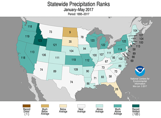
Jan-May Statewide Precipitation Ranks
Extremes
- The USCEI for the year-to-date was more than double the average and the second highest value on record. On the national scale, extremes in warm maximum and minimum temperatures, one-day precipitation totals, days with precipitation, and the spatial extent of wetness were above average.
- On the regional scale, the Northeast, Ohio Valley, Upper Midwest, Southeast, South and West all had much-above-average CEI values for the year-to-date with record high CEI values for the Ohio valley and Southeast. In each of the regions, extremes in warm maximum and minimum temperature contributed to the high CEI. In the Northeast, the element that tracks days with precipitation was record high. In the Upper Midwest, days with precipitation and the spatial extent of wetness was above average. In the Southeast, the spatial extent of drought was much above average. Record high one-day precipitation totals boosted the CEI in the South, while in the West the spatial extent of wetness and one-day precipitation totals were much above average.
Regional Highlights:
These regional summaries were provided by the six Regional Climate Centers and reflect conditions in their respective regions. These six regions differ spatially from the nine climatic regions of the National Centers for Environmental Information.
- Northeast Region: (Information provided by the Northeast Regional Climate Center)
- With an average temperature of 55.5 degrees F (13.1 degrees C), May was 0.8 degrees F (0.4 degrees C) colder than normal in the Northeast. Ten of the twelve states were colder than normal, with departures ranging from 1.3 degrees F (0.7 degrees C) to 0.6 degrees F (0.3 degrees C) below normal. Delaware wrapped up May at normal, while West Virginia was 0.4 degrees F (0.2 degrees C) warmer than normal. Despite a cold March and below-normal temperatures in May, a record warm April helped the Northeast average out to be 46.0 degrees F (7.8 degrees C) during spring, 0.4 degrees F (0.2 degrees C) warmer than normal. Six states were warmer than normal, with three ranking this spring among their top 20 warmest: Delaware, 10th warmest; West Virginia, 13th warmest; and Maryland, 14th warmest. Average temperature departures for all twelve states ranged from 0.9 degrees F (0.5 degrees C) below normal in Maine to 2.2 degrees F (1.2 degrees C) above normal in West Virginia. On May 18, LaGuardia Airport, New York, and Burlington, Vermont, tied their warmest spring temperatures on record with highs of 97 degrees F (36 degrees C) and 93 degrees F (34 degrees C), respectively. At several other sites, the high temperatures ranked among the top five warmest for spring.
- The Northeast ended May on the wet side of normal. The region received 5.53 inches (14.05 mm) of precipitation, 137 percent of normal, making it the eighth wettest May since 1895. All twelve states received above-normal precipitation, with ten ranking this May among their top 20 wettest: Rhode Island, sixth wettest; New Hampshire, seventh wettest; New Jersey, ninth wettest; Delaware, Maine, and Massachusetts; 12th wettest; New York, 13th wettest; Maryland and Vermont, 18th wettest; Pennsylvania, 20th wettest. Precipitation for the twelve states ranged from 118 percent of normal in Connecticut to 169 percent of normal in Rhode Island. Receiving 13.76 inches (34.95 mm) of precipitation, 123 percent of normal, the Northeast had its sixth wettest spring since recordkeeping began. Each of the twelve states was wetter than normal, with eight ranking this spring among their top 20 wettest: New York, sixth wettest; Rhode Island, 11th wettest; Pennsylvania, 12th wettest; Vermont, 13th wettest; Massachusetts, New Hampshire, and New Jersey, 16th wettest; and West Virginia 18th wettest. Precipitation for all states ranged from 101 percent of normal in Connecticut to 137 percent of normal in New York. Buffalo and Rochester, New York, received an entire May's worth of rain in just the first week (May 1 to 7), which contributed to the sites having their second wettest spring on record.
- The U.S. Drought Monitor released on May 4 indicated 3 percent of the Northeast was in a moderate drought, with another 8 percent being abnormally dry. Above-normal precipitation in April and May eased drought conditions so that by mid-May, the region became free of drought for the first time since April 2016. However, abnormally dry conditions lingered in parts of Pennsylvania and Connecticut through the month. May average streamflow was near to above normal. Groundwater and reservoir levels were near to above normal in many areas, but below-normal levels remained in a few spots. With improving conditions, drought declarations eased in several states.
- A line of severe thunderstorms produced eight weak (EF-0 or EF-1) tornadoes and straight-line winds of up to 100 mph (45 m/s) as it moved through Pennsylvania and New York on May 1. The storms snapped or uprooted hundreds of trees, damaged dozens of buildings, dropped heavy rain that led to flash flooding, and left more than 100,000 customers in Pennsylvania and more than 75,000 customers in New York without power. All eight tornadoes touched down in Pennsylvania. For comparison, the state averages three tornadoes for the month of May (based on data from the NOAA's Storm Prediction Center from 1889-2013). On May 18, a round of severe thunderstorms in New York and New England produced tennis ball-sized hail (2.5 in., 6.4 cm) and wind gusts up to 100 mph (45 m/s), which damaged numerous trees, buildings, and cars. Preliminary data from the U.S. Army Corps of Engineers indicated that the Lake Ontario basin had its wettest May since 1900. Above-normal precipitation during spring contributed to record-high water levels on Lake Ontario and the St. Lawrence River, which resulted in flooding and significant erosion along those waterways in New York. Homes and buildings were flooded, roads were closed, and boat launches, docks, and beaches were submerged. The high water washed away land, trees, and breakwalls, and left a few homes and cottages on the verge of falling into the lake. Wet conditions during May delayed planting and fieldwork in many parts of the Northeast but helped pastures green up.
- For more information, please go to the Northeast Regional Climate Center Home Page.
- Midwest Region: (Information provided by the Midwest Regional Climate Center)
- May precipitation was plentiful in much of the Midwest but there were also locations that received less than normal amounts. Totals ranged from under 50 percent of normal in northwestern Minnesota to more than 150 percent of normal in locations across all nine Midwest states. Three swaths of above normal precipitation extended from southwest to northeast: one from western Iowa to Upper Michigan, another from southern Missouri to Lake Erie, and the last across southeastern Kentucky. Spring (March-May) precipitation totals for the Midwest were 127 percent of normal, ranking as the 6th wettest on record (1895-2017). Six states ranked among their wettest 10 percent on record with Missouri ranking 4th and Wisconsin ranking 5th. The April-May two-month totals in Missouri set a new record with 15.47 inches (393 mm) topping the 15.22 inches (387 mm) from 1927. Flooding was an issue across the southern parts of Missouri, Illinois, and Indiana both early in the month and mid-month. Another area with flooding issues was southern Minnesota and western Wisconsin mid-month. Measureable snowfall fell in Iowa, Minnesota, Wisconsin, and Michigan during May with the highest totals in Minnesota of up to 5 to 7 inches (13 to 18 cm). Seasonal snowfall totals for the winter as a whole were well below normal in the southern half of the Midwest, with totals less than half of normal. In the northern third of the Midwest seasonal totals were closer to normal with a mix of above and below normal areas.
- May temperatures averaged to near normal for much of the Midwest. Some areas around Lake Superior had temperatures 2 to 4 degrees F (1 to 2 C) below normal but the rest of the region fell within 2 degrees F (1 C) of normal. Daily temperature records numbered over 300 record highs and nearly 500 record lows in May. There were many record low maximum temperatures in the first week of May, some record high maximum and minimum temperatures from the 16th to the 18th, and then more record low maximum temperatures from the 20th to the 23rd. Spring temperatures averaged near normal for the northern half of the Midwest and averaged just over 2 degrees F (1 C) above normal for the southern third of the region.
- About half of the Midwest had their last freezing temperature of the season in May. Many locations in the northern half of the region and in the eastern half dropped to freezing at least once in May. Missouri was the only Midwest state that had no freezing temperatures during the month. Temperatures dropped to the lower 20s F (below -4 C) in Minnesota, Wisconsin, and Michigan. Some fruit trees in Michigan sustained freeze damage on the 8th and 9th.
- Severe weather in May was hit or miss. Michigan had just three reports of severe weather for the entire month while the other Midwest states were fairly active with nearly 1500 reports across the region. There were seven days in May with no severe weather reports and another 11 days with fewer than 10 reports. On the other hand, there were five days (15th-18th and 27th) with over 100 reports on each day. An EF-2 tornado in Wisconsin killed one and injured 25 others on the 16th. Non-thunderstorm winds on the 17th killed two. One death was in Missouri where a rotten tree was felled by the strong winds. Across central Illinois, strong winds whipped up dust storms that closed portions of Interstate 72 and led to a multi-vehicle accident on US Highway 36 with one fatality.
- There was no drought in the region during May according to the US Drought Monitor. The month began with no areas of abnormally dry conditions in the region for the first time since May 2002. Abnormally dry conditions developed across northwestern Minnesota as the month went on, ending the month with about 5 percent of the region affected.
- For further details on the weather and climate events in the Midwest, see the weekly and monthly reports at the Midwest Climate Watch page.
- Southeast Region: (Information provided by the Southeast Regional Climate Center)
- Temperatures were near average across much of the Southeast region (including Puerto Rico and the U.S. Virgin Islands) during May. Only ten long-term (i.e., period of record equaling or exceeding 50 years) stations across the region observed May mean temperatures that were ranked within their top 5 warmest values on record, including Miami, FL (1896-2017; second warmest), Tampa, FL (1890-2017; fourth warmest), and Cape Hatteras, NC (1893-2017; tied for fourth warmest). From the 24th through the 31st, Miami tied its second longest streak of eight consecutive days during May with a maximum temperature at or above 90 degrees F (32.2 degrees C). On the 28th, Miami observed its warmest May day and tied its second warmest day for any month on record, reaching 98 degrees F (36.7 degrees C). This was also the highest temperature recorded in Miami outside of the three meteorological summer months (June, July, and August). Despite the lack of monthly temperature extremes across the region, periods of exceptionally warm and cold temperatures were observed during May. The warmest weather of the month occurred from the 17th through the 20th, as unseasonably warm, moist air surged northward around a strong Bermuda High off the Atlantic coast. Daily maximum temperatures exceeded 85 degrees F (29.4 degrees C) across much of the region, with numerous locations in every state reaching 90 degrees F or higher. From the 16th through the 20th, Tampa, FL observed its second longest streak of five consecutive days in which a daily maximum temperature record was tied or broken. On the 17th and 19th, Tampa tied its warmest May day and its second warmest day for any month on record, reaching 98 degrees F. Sarasota-Bradenton, FL (1911-2017) tied its second warmest daily maximum temperature for May (97 degrees F, 36.1 degrees C) on three consecutive days during the month (17th-19th). In contrast, the coolest weather of the month occurred on the 5th and 12th, as persistent cloud cover and rainfall suppressed daytime temperatures across portions of the region. Daily maximum temperatures ranged from the lower 50s F (10.6 to 11.7 degrees C) to the lower 60s F (16.1 to 17.2 degrees C) across broad areas of Alabama, Georgia, and western North Carolina on the 5th, as well as much of Virginia and the northern half of North Carolina on the 12th. On the 5th, ten long-term stations in Alabama and Georgia observed or tied their lowest daily maximum temperature on record for May, including Birmingham, AL (1896-2017; 52 degrees F, 11.1 degrees C) and Columbus, GA (1902-2017; 57 degrees F, 13.9 degrees C).
- Precipitation was well above normal across much of the Southeast region during May, but a few areas of unusual dryness were also observed. The driest locations were found across portions of the Florida Peninsula, Puerto Rico, and the U.S. Virgin Islands, where monthly precipitation totals were 10 to 50 percent of normal. In contrast, the wettest locations were found across much of Georgia, the Carolinas, Virginia, east-central and southern Alabama, the Florida Panhandle, and portions of the Florida Peninsula. Monthly precipitation totals ranged from 150 to over 300 percent of normal in these areas. Indeed, every state across the region had at least one station (including CoCoRaHS) that observed 10 inches (254 mm) of precipitation or greater during the month. At least 24 long-term stations observed May precipitation totals that were ranked within their three highest values on record. Half of these stations observed their wettest May on record, including Jefferson, NC (1896-2017; 12.83 inches, 326 mm), Montgomery, AL (1873-2017; 12.74 inches, 324 mm), Stuart, VA (1923-2017; 12.10 inches, 307 mm), and Savannah, GA (1871-2017; 11.54 inches, 293 mm). From the 20th through the 21st, a slow-moving system of thunderstorms produced widespread heavy rainfall across Alabama, with flash flooding occurring in the three major cities of Birmingham, Montgomery, and Mobile. Multiple water rescues were performed in the Birmingham metropolitan area, and several submerged vehicles were reported in Montgomery. On the 20th, Montgomery observed its wettest May day and fourth wettest day for any month on record, with 8.15 inches (207 mm) of precipitation. Of this daily total, 7.31 inches (186 mm) was recorded in only 6 hours, which corresponds to an average recurrence interval of approximately 200 years at this location. On the 22nd, Savannah, GA observed its highest 1-day precipitation total on record for meteorological spring (March, April, and May), with 6.61 inches (168 mm) of rainfall. From the 19th through the 25th, Greensboro, NC (1903-2017) observed its longest streak during May with seven consecutive days of measurable precipitation.
- There were 741 severe weather reports across the Southeast during May, which is nearly 140 percent of the median monthly frequency of 534 reports during 2000-2016. At least one severe weather report was recorded on 22 days during the month, but about 45 percent (336 of 741) of the reports were recorded on just three of these days (4th, 24th, and 27th). Approximately 55 percent (415 of 741) of all reports occurred in North Carolina and Virginia. There were 10 reports of large hail (i.e., at least 2 inches in diameter or hen egg-sized) across the region during the month, including 3-inch (tea cup-sized) hail in Chesterfield County, VA on the 27th, 2.75-inch (baseball-sized) hail in Edgefield County, SC on the 29th, and 2.75-inch hail in Duval County, FL on the 31st. Numerous reports of damaging thunderstorm wind gusts, ranging from 50 to 90 mph, occurred across the region, resulting in 1 fatality and at least 12 injuries during the month. On the 20th, a line of severe thunderstorms produced wind gusts up to 90 mph across a broad swath of north-central Alabama. There were widespread reports of downed trees and power lines, with many homes in the Huntsville metropolitan area sustaining damage. On the 30th, thunderstorm wind gusts estimated from 80 to 90 mph caused trees to fall onto several homes and vehicles across Sampson County, NC, resulting in at least 12 injuries. Approximately 16,000 turkeys were killed, as the strong winds destroyed numerous poultry houses. Damaging non-convective wind gusts, ranging from 30 to more than 60 mph, were observed across northern and central portions of Alabama and Georgia on the 4th. The combination of strong winds and wet soils from recent rainfall produced widespread downed trees and power lines in these areas, resulting in motor vehicle accidents and structural damage to homes and businesses. Some of the highest observed wind gusts were 64 mph in Cohutta, GA, 48 mph at Birmingham International Airport, AL, and 44 mph at Hartsfield-Jackson International Airport in Atlanta, GA. A total of 54 tornadoes (2 unrated, 22 EF-0s, 25 EF-1s, 5 EF-2s) were confirmed across the region during the month, which is nearly five times greater than the median frequency of 11 tornadoes observed during May. In fact, this is the fifth greatest May tornado count for the region since modern records began in 1950. Twenty tornadoes were confirmed in Georgia, which is the second greatest May tornado count for the state since 1950, trailing only the 23 tornadoes observed during May 2008. Over 90 percent (49 of 54) of the tornadoes and all 11 tornado-related injuries occurred during multi-day severe weather outbreaks on the 4th through the 5th and the 23rd through the 24th. On the 4th, an EF-1 tornado touched down in Garden City, GA and injured five people inside an auto parts store, as three of the exterior walls collapsed. On the 24th, an EF-2 tornado tracked 6.1 miles across Davie and Yadkin Counties in central North Carolina, with two reported injuries. At least 45 homes and other structures were damaged or destroyed along its path, including an elementary school gymnasium. On the 17th, a construction worker was injured by a lightning strike in Martin County, FL.
- While drought conditions were nearly or totally eliminated from several states across the region, portions of Georgia and Florida remained in moderate-to-extreme (D1-D3) drought during May. Persistent rainfall in early May removed lingering areas of moderate drought in North Carolina and Virginia. Drought conditions were nearly eliminated in Alabama during the month, as the coverage of moderate-to-severe (D1-D2) drought decreased from 32 percent on May 2nd to less than 1 percent on May 30th. Only a few small areas of moderate drought remained in South Carolina, and the coverage of moderate-to-severe drought was significantly reduced across portions of northern and central Georgia, including the removal of extreme drought in the northeastern corner of the state. In contrast, moderate-to-severe drought persisted over much of southern Georgia, while moderate-to-extreme drought continued to intensify and expand across Florida, covering nearly 72 percent of the state for the first time since February 2013. Much-below-normal streamflows and soil moisture persisted across southern Georgia and Florida due to a lack of rainfall. An extremely active wildfire season continued across Florida, with over 550 wildfires reported and nearly 60,000 acres burned during the month. The West Mims Fire in southeastern Georgia consumed an additional 50,000 acres of the Okefenokee National Wildlife Refuge during May, reaching a total of 150,000 acres since the fire began in early April. Beginning on May 6th, southern portions of Charlton County, GA, including about 2,000 residents in the community of St. George, were placed under a week-long mandatory evacuation order due to a rapid spreading of the West Mims Fire. The flames and smoke from the wildfire caused a significant reduction in tourism to the Okefenokee Swamp during May, which is typically one of its busiest months of the year. On the 6th, heavy smoke and falling ash were reported in downtown Jacksonville, FL, located about 30 miles from the fire perimeter. Pastures remained thin and drought-damaged across southern portions of the region, with harmful armyworms reported in areas of Alabama and Georgia. Many livestock producers in Florida continued to feed hay and haul in water from outside the state. Above-average precipitation during May and much of spring contributed to a successful first cutting of hay across the northern half of the region, but some livestock producers in North Carolina reported unusually thin yields due to the recent drought. Persistent rainfall during early and late May stalled crop planting and winter wheat harvesting across much of the region. Some corn and tobacco had to be replanted in North Carolina and Virginia, as heavy rainfall saturated fields and leached soil nutrients. However, farmers in Georgia and South Carolina reported that the rainfall at the end of the month was timely for the corn crop, which had begun to silk and tassel. Hundreds of acres of tomato and watermelon crops in southwestern Florida were destroyed by an extreme infestation of whiteflies, which was attributed to warm and dry weather during spring as well as an unseasonably warm winter across the state.
- For more information, please go to the Southeast Regional Climate Center Home Page.
- High Plains Region: (Information provided by the High Plains Regional Climate Center )
- Wet conditions continued in May for parts of the High Plains region, including eastern Colorado, western and central Kansas, and much of Nebraska. The spring season, which is defined as the March-May period, was very wet for these areas and for central Wyoming as well. The following top 10 records for wettest spring occurred throughout the region: Dodge City, KS (2nd wettest), Goodland, KS (3rd wettest), Pueblo, CO (3rd wettest), Lander, WY (4th wettest), Chadron, NE (5th wettest), and Casper, WY (9th wettest). Rocky Mountain snowpack was impressive this season, as Snow Water Equivalent (SWE) in the Upper Missouri Basin was above normal for most of the season and snowpack peaked two weeks later normal in late April/early May. The combination of above-normal snowpack and increasing temperatures have already caused flooding in Colorado and Wyoming, and more flooding is expected downstream as snowmelt continues to run off. The wet spring and untimely cool temperatures contributed to several problems in the agricultural fields in Kansas and Nebraska. In Kansas, wheat stripe rust continued to spread across the state. The fields that were impacted by the heavy snow event in western Kansas in late April/early May are still being evaluated, but some damage has already been spotted. In Nebraska, black stem disease was reported in alfalfa in the western part of the state, and Wheat Streak Mosaic Virus became prevalent in the southern Panhandle. Producers in both states were concerned about the excess moisture causing root rot and diseases in corn.
- In contrast, it was dry across much of the Dakotas during the spring, and precipitation deficits accumulated quickly. According to the U.S. Drought Monitor, drought spread rapidly across the Dakotas in May as impacts became more apparent. Below-normal spring temperatures delayed planting and slowed crop growth in this region. During the month of May, the percent of topsoil moisture rated short to very short increased from 7 percent to 36 percent in North Dakota and from 12 percent to 38 percent in South Dakota. This is something to watch closely as we head into summer.
- The pattern of near-normal temperatures experienced by much of the region in April continued into May in the High Plains, although temperatures tended to be more on the cool side. Temperatures throughout the central and southern parts of the region ranged from near normal to about 2.0 degrees F (1.1 degrees C) below normal, while they were slightly above normal in portions of the Dakotas.
- Despite near-normal temperatures in April and May, the impressive warmth of March caused most of the region to have a warmer-than-normal spring. For instance, Colorado Springs, Colorado had its 5th warmest spring, while it was the 7th warmest for Cheyenne, Wyoming, mostly due to the extremely warm temperatures in March.
- A negative impact of this type of pattern was plants and crops emerged early, then were subjected to sub-freezing temperatures while at growth stages that cannot sustain those types of temperatures for a long period of time. Cooler temperatures and freeze injury contributed to sugar accumulation and stripe rust in winter wheat in Kansas, and fluctuating soil temperatures put early planted corn at risk for seedling disease development in Nebraska. Unlike the rest of the region, parts of the Dakotas were particularly cool throughout most of the spring, which caused delays in planting and crop growth. Fortunately, the delays protected crops from late-season freezes because they were in early growth stages, and warmer temperatures in May helped accelerate growth. However, delayed planting raises the risk of freeze injury in the fall. To assess fall frost risk in corn, check out the Useful to Usable Corn Growing Degree Day (GDD) decision support tool on our webpage: https://hprcc.unl.edu/gdd.php.
- A negative impact of this type of pattern was plants and crops emerged early, then were subjected to sub-freezing temperatures while at growth stages that cannot sustain those types of temperatures for a long period of time. Cooler temperatures and freeze injury contributed to sugar accumulation and stripe rust in winter wheat in Kansas, and fluctuating soil temperatures put early planted corn at risk for seedling disease development in Nebraska. Unlike the rest of the region, parts of the Dakotas were particularly cool throughout most of the spring, which caused delays in planting and crop growth. Fortunately, the delays protected crops from late-season freezes because they were in early growth stages, and warmer temperatures in May helped accelerate growth. However, delayed planting raises the risk of freeze injury in the fall. To assess fall frost risk in corn, check out the Useful to Usable Corn Growing Degree Day (GDD) decision support tool on our webpage: https://hprcc.unl.edu/gdd.php.
- Severe weather occurred in every state in the High Plains region during May. A couple of storm systems were particularly noteworthy. On the 8th, severe thunderstorms produced giant hail that pummeled Denver, Colorado and the surrounding area. Hail size exceeded 2.0 inches (5 cm) across Denver and Jefferson Counties and damaged homes, businesses, and over 100,000 vehicles. Damage is still being assessed, but it is likely that this storm will become a Billion-Dollar Weather Disaster. Another storm system brought several tornadoes and instances of high wind to parts of Kansas and Nebraska on the 16th. In particular, Omaha, Nebraska and the surrounding area received wind gusts in excess of 80 mph (129 km/hr), which flipped over a plane at Eppley Airfield and knocked out power to 17,000 residents.
- Given that it is spring on the Plains, it should come as no surprise that snowstorms impacted the region as well. A particularly strong spring storm system dumped several feet of snow in the Colorado Mountains and Foothills from the 18th-20th. According to several weather stations around the area, 30.0-40.0 inches (76-102 cm) of snow fell in Estes Park, which made travel nearly impossible into and out of Rocky Mountain National Park. Southeastern Wyoming was also impacted by this system, as Interstate 80 and several other major highways were forced to close. Cheyenne, Wyoming received 14.3 inches (36 cm) of heavy snow from this system, which damaged trees and downed power lines. Normal snowfall in May for Cheyenne is only 2.3 inches (6 cm), so this system led to Cheyenne having its 6th snowiest May on record.
- Snowpack peaked and slowly began to decline in the Rockies of Colorado and Wyoming during May. According to the U.S. Army Corps of Engineers, Snow Water Equivalent (SWE) above Fort Peck Dam peaked on April 29 and was 104 percent of average at the end of May. Snowpack between Fort Peck and Garrison Dams peaked on May 2 but began to build again during mid-late May. SWE for this stretch was 164 percent of average by the end of the month. The Missouri River Basin mountain snowpack normally peaks near April 15, but both reaches peaked about two weeks later than average. As a result of the above-normal snowpack in Wyoming, streams ran much above normal to high during May and flooding occurred. Wet conditions caused much-above-normal streamflow throughout eastern Colorado, central Kansas, and eastern Nebraska.
- The drought depiction for the High Plains changed drastically during May, as both improvements and degradations occurred throughout the region. The area in drought or abnormal dryness (D0-D4) only increased from 20 percent to 25 percent during the month, but a closer look at several parts of the region revealed that conditions changed quickly.
- Improvements in drought and dryness occurred throughout Kansas, Nebraska, Colorado, and Wyoming. These states experienced excessively wet conditions during much of the spring, which alleviated the dryness. As of the end of May, Colorado, Nebraska, and Kansas were drought free, and less than one percent of Wyoming was experiencing drought. It is worth noting that very little drought existed in the U.S. during May. In fact, the May 23rd depiction of the U.S. Drought Monitor showed that only 4.52 percent of the nation was in drought (D1-D4), which was the smallest area since the U.S. Drought Monitor's inception in 2000.
- In contrast, drought and abnormal dryness expanded across the Dakotas in May. Much of this region had a dry spring, and the central Dakotas received no more than 50 percent of normal precipitation. Poor water quality in stock ponds, stressed winter wheat, and poor growth in seasonal grasses were reported in northern South Dakota/southern North Dakota. However, fall moisture was helping some areas get through the dry spring, and the dryness was welcomed by producers conducting field work.
- For more information, please go to the High Plains Regional Climate Center Home Page.
- Southern Region: (Information provided by the Southern Regional Climate Center)
- May was cooler than normal for all states in the southern region besides Tennessee. Parts of Texas, Central Louisiana, and northwestern Oklahoma had reports of 3 to 4 degrees F (1.667 to 2.222 degrees C) below normal temperatures for May. Most of Arkansas, Mississippi, Louisiana, Oklahoma, and Texas were 1 to 3 degrees F (0.556 to 1.667 degrees C) below normal temperatures. The central and eastern part of Tennessee had 0 to 2 degrees F ( 0 to 1.111 degrees C) above normal temperatures. There were also clusters of near to above normal temperatures in all of the other states except Louisiana. The statewide monthly average temperatures were as follows: Arkansas reporting 67.70 degrees F (19.83 degrees C), Louisiana reporting 71.70 degrees F (22.06 degrees C), Mississippi reporting 70.20 degrees F (21.22 degrees C), Oklahoma reporting 66.80 degrees F (19.33 degrees C), Tennessee reporting 66.70 degrees F (19.28 degrees C), and Texas reporting 72.00 degrees F (22.22 degrees C). The state-wide temperature rankings for May are as follows: Arkansas (forty-third coldest), Louisiana (seventeenth coldest), Mississippi (thirty-ninth coldest), Oklahoma (thirty-fifth coldest), Tennessee (fifty-third warmest), and Texas (forty-ninth warmest). All state rankings are based on the period spanning 1895-2017.
- Precipitation values for the month of May varied spatially across the Southern Region. Precipitation totals in parts of eastern Texas, southern Louisiana, and southern Mississippi were 300 percent of normal. Each of the six states in the region had areas 150 to 300 percent of normal precipitation. In contrast, conditions were quite dry across north, central, and western Texas, southern Oklahoma, southwest Arkansas and west central Mississippi with stations reporting between 5 to 70 percent of normal. All states had clusters of normal, below normal and above normal levels of precipitation values. Most of Louisiana and Arkansas reported above normal precipitation values. The four other states in the region, Texas, Tennessee, Oklahoma and Mississippi had great contrasts of precipitation reports throughout their states. The state-wide precipitation totals for the month are as follows: Arkansas reporting 6.54 inches (166.12 mm), Louisiana reporting 8.95 inches (227.33 mm), Mississippi reporting 6.55 inches (166.37 mm), Oklahoma reporting 4.07 inches (103.38 mm), Tennessee reporting 5.89 inches (149.61 mm), and Texas reporting 2.51 inches (63.75 mm). The state precipitation rankings for the month are as follows: Arkansas (thirty-first wettest), Louisiana (ninth wettest), Mississippi (twenty-second wettest), Oklahoma (forth-ninth driest), Tennessee (twenty-first wettest), and Texas (thirty-ninth driest). All state rankings are based on the period spanning 1895-2017.
- Over the month of May 2017, drought conditions improved for some parts of the region, such as areas in eastern Oklahoma, northern Louisiana, and western Arkansas. There were areas in northern Texas and a few counties in central Texas the entered moderate drought. Northeastern Mississippi stayed in moderate drought conditions from April into May. During the month of May, all of Tennessee and most of Oklahoma, Arkansas, and Louisiana experienced normal conditions. At this time, there are no areas experiencing extreme or exceptional drought.
- On May 2, 2017, there were 20 total hail reports in Texas and Oklahoma. There was also an 82 mph (131.97 kph) wind gust in Talala, Oklahoma.
- On May 3, 2017, there were two tornado reports in Texas, 85 total hail reports throughout Oklahoma, Arkansas, Texas, and Louisiana. Rapides parish in Louisiana had reports of tennis ball sized hail which damaged windshields. There were more than 50 wind reports throughout the region, with a 93 mph (149.67 kph) wind report in Venice, Louisiana.
- On May 9, 2017, there were five reports of tornadoes in western Texas and about a dozen reports of severe hail in Texas. Donley, Texas reported baseball sized hail.
- On May 10, 2017, there were over 40 total reports of hail in Texas and Oklahoma. There was a 72 mph (115,87 kph) wind speed recorded in Tillman, Oklahoma.
- On May 11, 2017, there were 13 tornadoes reported throughout Texas, Oklahoma, and Louisiana. There were reports of tennis ball sized hail in Kingfisher, Oklahoma and baseball sized hail in Logan, Arkansas. A strong wind event of 78 mph (125.53 kph) was reported in Stillwater, Oklahoma.
- On May 12, 2017, there were four tornadoes reported in Louisiana with one tornado injuring a person in Baton Rouge, Louisiana. A strong gust of wind caused a tree to fall on a car and injure a person in Hammond, Louisiana.
- On May 16, 2017, there were 18 tornado reports between Texas and Oklahoma. A tornado in Beckham, Oklahoma damaged many homes, replaced roofs, and caused one home to collapse.
- On May 18, 2017, there were 17 tornadoes reported throughout Texas, Oklahoma, and Arkansas. There were over 70 hail reports between Texas and Oklahoma. In Walters, Oklahoma there was a 104 mph (167.37 kph) wind report.
- On May 19, 2017, eight tornadoes were reported between Texas and Oklahoma. There were reports of softball sized hail in Coleman, Texas and tennis ball sized hail in Wichita, Texas.
- On May 21, 2017, there were 19 hail reports between Texas, Oklahoma, and Mississippi, with baseball sized hail reported in Webb, Texas. In Laredo, Texas a 14 year old boy was electrocuted and killed after picking up a downed live power line.
- On May 22, 2017, there were two tornado reports in Texas. One of the tornadoes in Galveston, Texas caused damage to a Holiday Inn.
- On May 27, 2017, there were three tornadoes in Oklahoma and one in Arkansas. In Stephens, Bryans Corner, and Hooker, Oklahoma baseball sized hail with damage to property was reported. An injury occurred from a wind event in Crawfordsville, Arkansas when a tree fell on two mobile homes. Another person was injured in Shelby, Tennessee when a tree fell on a trailer and the person was trapped for a short amount of time.
- On May 28, 2017, there were five tornadoes between Texas and Louisiana. Tea cup sized hail was reported in Edwards, Texas. A wind event in Caldwell, Louisiana caused the death of an 18 year old.
- For more information, please go to the Southern Regional Climate Center Home Page.
- Western Region: (Information provided by the Western Region Climate Center)
- Characteristic of the transition from spring to summer, periods of dry and above normal temperatures alternated with wetter conditions and below normal temperatures during May. Temperatures averaged to near normal across most of the West, and only a small area of the eastern Sierra Nevada and a swath of the Southwest observed well above normal precipitation.
- Monthly temperature anomalies throughout the West were generally within 4 F (2.2 C) of normal. Warmer than average conditions were observed along the northern tier of the region as well as in Nevada, Oregon, and northern and central California. In north-central California, Orland reported an average May temperature 70.9 F (21.6 C), 3.6 F (2 C) above normal. Further north, Medford, Oregon, observed 63.3 F (17.4 C), 3.5 F (2 C) above normal and the 6th warmest May since records began in 1911. May temperatures were slightly cooler than average across much of the Four Corners states as well as parts of Utah, Wyoming, and southern California. At an average of 56.8 F (13.8 C) for the month, Trinidad, Colorado, was 2.4 F (1.3 C) below normal. In southwest Utah, St. George recorded an average of 70.5 F (21.4 C) for the month, 1.8 F (1 C) below normal.
- Large areas of the West observed below normal precipitation, particularly in northern and central California, eastern Oregon, Nevada, eastern Montana, southern New Mexico and Utah. In central California, Oakland observed only trace precipitation, tie with 14 other years for the driest May in a 70-year record. Normal May precipitation in Oakland is 0.68 in (17 mm). Further north, Klamath Falls, Oregon, reported 0.29 in (7 mm), 21% of normal and tie for 7th driest May since records began in 1948. In northeastern Montana, Glasgow observed 0.58 in (15 mm), 30% of normal and the 7th driest May since records began in 1948. Moderate drought conditions persisted in southern California and southern Arizona this month as well as expanded in the southern Arizona-New Mexico border area. Abnormally dry conditions were noted in the US Drought Monitor in a large area of northeastern Montana.
- Precipitation was near normal for much across Washington as well as western Oregon, southwestern Montana, and southern Wyoming. Well above normal precipitation was observed in a broad swath stretching from southern California across northern Arizona and into eastern Colorado, mostly resulting from a slow-moving cutoff low-pressure system that moved through the area May 7-10. Some of these areas typically receive little May precipitation, so percentages of normal are quite high despite relatively low precipitation totals. In far southern California, San Diego reported 0.92 in (23 mm), 760% of normal and the 4th wettest May in a 79-year record. Further east, Laughlin, Nevada, received 0.65 in (17 mm), 1300% of normal and the wettest May in a 30-year record. In southern Colorado, Pueblo logged 198% of normal precipitation with 3.0 in (76.2 mm), the 5th wettest May since records began in 1954. Above normal May precipitation helped alleviate a small area of drought conditions in Colorado, leaving the state drought-free in the US Drought Monitor at month's end.
- In Alaska, May was slightly wetter than normal with near-normal temperatures. Most stations received at least 75% of normal May precipitation and many recorded above normal. Notably, the 0.94 in (24 mm) observed at Utqia'vik was 520% of normal and the wettest in the station's 117-year record. In the southwestern part of the state, Bethel observed 2.31 in (59 mm), 203% of normal and the 5th wettest since records began in 1923. Temperatures were above normal in the northern portion of the state; Kotzebue reported an average of 34.8 F (1.6 C) for the month, 2.9 F (1.6 C) above normal and Utqia'vik observed 24.6 F (-4.1 C), 3.4 F (1.9 C) above normal. South of the Alaska Range, temperatures were below normal, especially in coastal southeast Alaska. For example, Cordova recorded an average May temperature of 43.5 F (6.4 C), 1.9 F (1.1 C) below normal. Further south, an unseasonably late Kona low brought precipitation and flash flooding to Maui and Big Island in Hawaii. Aside from this event, conditions were generally near normal or drier than normal across the state. Kahului, Maui, observed a total of 0.08 in (2 mm) rainfall, 11% of normal and Lihue, Kauai reported 1.58 in (40 mm), 76% of normal. Temperatures were near to slightly above normal for most of the state; however, Lihue reported an average temperature of 77.9 F (25.5 C), 2.1 F (1.2 C) above normal and the 4th warmest since records began in 1950.
- All month: Snowmelt-driven flooding: Snow water equivalent in many basins in Washington, California, Idaho, and Nevada were well (>150%) above normal throughout the month. Multi-day periods of above normal temperatures combined with increasing solar radiation produced rapid melting of snow that sustained high and near-record flows on many streams and rivers with minor flooding reported along the Big Wood River in Hailey, Idaho, near the Truckee River near Tahoe City in California, and in the Mason Valley of Nevada in the floodplain of the Walker River.
- May 18: Winter storm in Colorado and Wyoming: A strong winter storm moved through the central Rocky Mountains bringing multiple feet of snow and cold temperatures. Allenspark, Colorado, received 42.5 in (108 cm) of snow in three days. Several major transportation routes including Highways 80 and 30 were temporarily closed as were many businesses and schools.
- Saturated soils result in massive Big Sur landslide: The exceptionally wet winter season in California resulted in saturated soils and contributed to numerous slope failures throughout the state. A massive landslide occurred in Big Sur on May 20, burying Highway 1 with an estimated 1 million tons of debris. The exact cause of this landslide is currently under investigation.
- For more information, please go to the Western Regional Climate Center Home Page.