National Overview:
As Northern Hemisphere autumn transitions into winter during this time of year, the angle of the sun above the horizon decreases, resulting in less solar heating of the northern latitudes. Temperatures cool, the atmospheric circulation intensifies, and strong extra-tropical cyclonic storms with associated cold fronts develop in the westerly flow. This is what happened in November as a very active  weather pattern brought a series of winter storms to the Lower 48 States. Several strong low pressure systems, or extra-tropical cyclones, developed in the West or central Plains, bringing beneficial snow to the mountains and snow cover to the northern tier states. About 12 percent of the country was snow covered by the 10th of the month, with the snow coverage increasing to a third of the country with snowstorms after the 21st. A few systems developed in the South. As the storm systems moved eastward, cold air was pulled in behind them. Near the end of the month, moisture drawn northward along the associated cold fronts brought locally heavy rains to the Ohio Valley and parts of the South, alleviating drought conditions in some areas. Strong winds along the front, and at least 20 tornadoes (including an EF-4 in Louisiana), caused damage in the Southeast and Eastern Seaboard.
Cold fronts and low pressure systems moving in the storm track flow are influenced by the broadscale atmospheric circulation. Two such large-scale atmospheric circulation patterns were dominant during November. The first was the La Niña, which is the phenomenon created by cooler-than-average sea surface temperatures in the eastern tropical Pacific Ocean. La Niña is typically associated with wet conditions in the northern tier states and Ohio Valley this time of year, and warm and dry conditions in the southern tier states. The second atmospheric circulation index was the Arctic Oscillation (AO), which was strongly negative during most of November. A negative AO is typically associated with dry conditions in the Southeast and colder-than-normal temperatures east of the Rockies at this time of year. In response to these two atmospheric indicators, Montana had the seventh wettest November on record and Indiana the 16th wettest, while North Carolina ranked 16th driest and New Mexico and South Carolina both ranked 18th driest. The opposing temperature influences of these two atmospheric patterns contributed to a national temperature rank near the middle of the historical distribution. The circulation patterns funneled moisture and above-normal temperatures into Alaska.
- Temperature Highlights
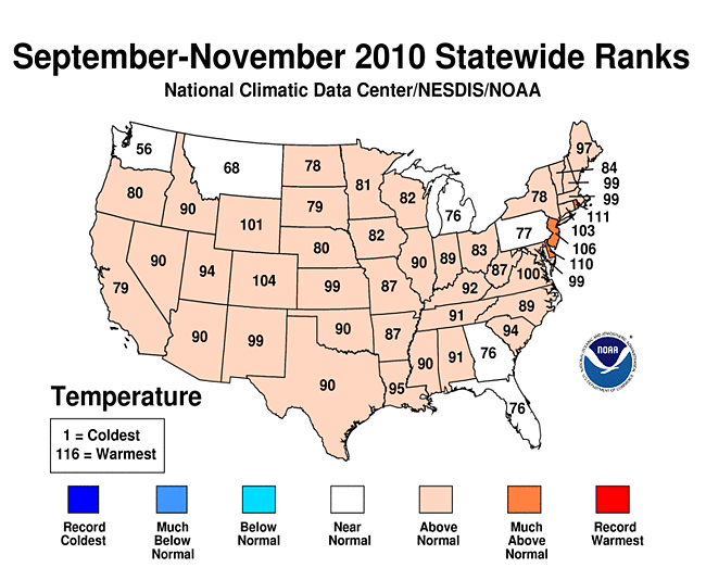
- November temperatures, when averaged across the contiguous United States, were near-normal, 0.8 degrees F (0.4 degrees C) above the 1901-2000 average. The combined average temperatures for the fall season (September-November) was 1.5 degrees F (0.8 degrees C) above normal.
- Warmer-than-normal conditions were scattered about the Great Lakes region and a portion of the Northeast. Cooler-than-normal conditions existed for a subset of states in the western half of the U.S.
- For the fall season (September-November), warmer-than-normal temperatures were predominant throughout much of the country. These conditions were mostly reflective from the above-average warmth during September and October.
- The Northeast climate region has experienced persistent warmth through the entire year, resulting in its warmest January-November period on record.
- Six states (New Hampshire, Vermont, Massachusetts, Rhode Island, Connecticut and New Jersey) had their warmest year-to-date period on record.
- Based on monthly temperatures averaged from January-November, Florida is the only state in the contiguous United States to experience a temperature that ranked below-normal.
- Precipitation Highlights
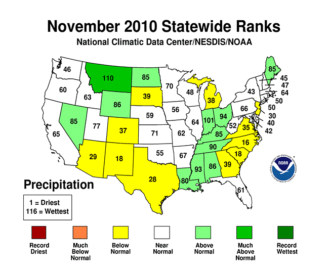
- The average precipitation was 2.02 inches (51.3 mm), 0.1 inch (2.54 mm) below the 1901-2000 average. With most of the climate regions near-normal, the above-average precipitation in the West North Central and Central climate regions offset the below-average precipitation in the Southwest resulting in a near normal month for the contiguous U.S. Montana had its seventh wettest November on record.
- Precipitation, when averaged across the U.S. for the fall period was near normal. However several states experienced precipitation that ranked among their wettest/driest ten percent. Both Maine and Minnesota had their sixth wettest period and it was the seventh wettest for Nevada and the ninth wettest for North Dakota. Meanwhile, the persistent lack of precipitation in Florida resulted in its second driest fall period on record.
- For the year-to-date period, the persistent storm track over the upper Midwest resulted in much-above-normal precipitation in Wisconsin, Minnesota, Iowa, North Dakota and South Dakota. Meanwhile, the Bermuda high situated in the western North Atlantic this past summer acted as a blocking pattern. This led to below-average precipitation for the Southeast climate region.
- Other Items of Note
- There were 57 preliminary tornado reports during November. This is near the long-term average, but marks the most tornado activity during November since 2005. Rare November tornadoes were reported in Wisconsin, Illinois, and New York — tornadoes are unusual this far north, this late in the year.
- Drought coverage continued to increased during November. The U.S. Drought Monitor reported 16.7 percent of the United States was affected by drought by November 30th. While improvements were seen across the Ohio River Valley, drought conditions deteriorated during the month in Florida, south Texas, and parts of southeast Colorado.
Alaska Temperature and Precipitation:
Beginning with January 2010 processing, the Alaska temperature and precipitation report is comprised of several datasets at NCDC, integrating GHCN and COOP datasets. Prior to 2010, the Alaskan temperature timeseries was processed with just GHCN data.
-
 Alaska
had its 23rd warmest November since records began in 1918, with a temperature 4.3°F (2.4°C) above the 1971–2000 average.
Alaska
had its 23rd warmest November since records began in 1918, with a temperature 4.3°F (2.4°C) above the 1971–2000 average.
-
 Alaska
had its 15th warmest September–November on record, with a temperature 3.1°F (1.7°C) above to the 1971–2000 average.
Alaska
had its 15th warmest September–November on record, with a temperature 3.1°F (1.7°C) above to the 1971–2000 average.
-
 Alaska
had its 19th warmest year–to–date on record, with a temperature 1.4°F (0.8°C) above the 1971–2000 average.
Alaska
had its 19th warmest year–to–date on record, with a temperature 1.4°F (0.8°C) above the 1971–2000 average.
-
 Alaska
had its 5th wettest November since records began in 1918, with an anomaly that was 57.2 percent above the 1971–2000 average.
Alaska
had its 5th wettest November since records began in 1918, with an anomaly that was 57.2 percent above the 1971–2000 average.
-
 Alaska
had its 42nd wettest September–November on record, with an anomaly that was 2.4 percent above the 1971–2000 average.
Alaska
had its 42nd wettest September–November on record, with an anomaly that was 2.4 percent above the 1971–2000 average.
-
 Alaska
had its 33rd driest year–to–date on record, with an anomaly that was 1.4 percent below the 1971–2000 average.
Alaska
had its 33rd driest year–to–date on record, with an anomaly that was 1.4 percent below the 1971–2000 average.
For additional details about recent temperatures and precipitation across the U.S., see the Regional Highlights section below. For information on local temperature and precipitation records during the month, please visit NCDC's Records page. For details and graphics on weather events across the U.S. and the globe please visit NCDC's Global Hazards page.
Regional Highlights:
These regional summaries were provided by the six Regional Climate Centers and reflect conditions in their respective regions. These six regions differ spatially from the nine climatic regions of the National Climatic Data Center.
- Northeast Region: (Information provided by the Northeast Regional Climate Center)
- The Northeast averaged 0.6 degrees F (0.3 degrees C) above normal during November with an average temperature of 39.8 degrees F (4.3 degrees C). This was the 11th consecutive month with warmer than normal temperatures, but the first month since February 2010 that at least one state in the region had a temperature average that was below normal. Maryland was that state, with an average that was 0.4 degrees F (0.2 degrees C) below normal. The remaining 11 states saw temperature departures ranging from 0.3 degrees F (0.2 degrees C) above normal in Massachusetts and West Virginia to 1.5 degrees F (0.8 degrees C) warmer than normal in Maine. Autumn 2010 (Sep-Nov) averaged 50.9 degrees F (10.5 degrees C), which was 1.4 degrees F (0.8 degrees C) above normal. This was 0.6 degrees F (0.3 degrees C) warmer than the autumn of 2009.
- Most of the Northeast ended up on the dry side in November, with Maine the one exception. The region averaged 3.20 inches (81.3 mm) of precipitation, most of which fell as rain. This was 86 percent of the normal November total. Maine's average precipitation total was 127 percent of normal; departures for the 11 other states in the region ranged from 56 percent of normal in New Jersey to 87 percent of normal in Massachusetts. The typical lake-effect areas of Pennsylvania and New York and the higher elevations in the region saw up to 10 inches (254 mm) of snowfall this month. Precipitation totals for the fall of 2010 averaged 12.12 inches (307.8 mm) or 109 percent of normal. Despite below normal precipitation in most of the Northeast, the U.S. Drought Monitor published November 30, 2010 indicated a slight improvement in the drought conditions. Portions of the eastern panhandle of West Virginia and the western panhandle of Maryland that were in severe drought (D2) a month ago improved to moderate drought (D1) at the end of November. Moderate drought conditions (D1) were still present in eastern West Virginia, while parts of western Pennsylvania and coastal New Jersey were abnormally dry.
- A powerful storm pounded northern New England on the 8th. Strong sustained winds, with gusts from 45-60 mph (20-27 m/s) downed trees and power lines in Maine and New Hampshire, cutting power to about 65,000 customers. There were numerous reports of blocked roads and structural damage; one fatality due to a downed tree was reported. Wrap-around moisture from the storm left up to 3 inches (7.6 cm) of slushy snow in eastern New York, 2 inches (5.1 cm) in southern Vermont and up to an inch (2.5 cm) in Rhode Island and southeastern Massachusetts.
- A macroburst with an embedded F1 tornado impacted the Baltimore, MD area on the 17th. Structural damage, downed and uprooted trees, and 3 injuries resulted from the 85-100 mph (38-45 m/s) winds generated by the storm.
- For more information, please go to the Northeast Regional Climate Center Home Page.
- Midwest Region: (Information provided by the Midwest Regional Climate Center)
- November precipitation was variable across the region. Precipitation was above normal from southeastern Missouri through Ohio, and 150 percent of normal from southern Indiana to southwestern Ohio. Most of this precipitation came during the last nine days of the month, when storms dropped from six to eight inches (15 to 20 cm) of rain in southern in Indiana. The heavy rain resulted in a significant improvement in the Severe to Extreme Drought in the Ohio Valley. However, normal to above normal precipitation will be needed in the coming months to further eradicate the dry conditions. Precipitation was also near to above normal in a narrow band from southwestern Iowa to northeastern Minnesota. In southwestern Minnesota and from northern Missouri into northern Lower Michigan precipitation was about 50 percent of normal.
- November temperatures were near to slightly above normal. Average daily temperatures ranged from near normal across the eastern third of the region to 1degree F to 3 degrees F (0.5 to 1.6 degrees C) in the eastern two-thirds. The greater departures were mostly in the upper Midwest. However, week to week changes in average temperatures were dramatic. During the first week of November temperatures were well above normal in the northwestern half and much below in the southeastern half. There was a major warm-up the second week of November and much of the region was from 7 degrees F to 13 degrees F (3.9 to 7.2 degrees C) above normal. The third week was significantly cooler region wide. Colder weather prevailed across the northern third of the Midwest the last nine days of the month.
- Significant snowfall in November was generally limited to an area from northwestern Iowa through the northwestern half of Minnesota, although there was some lake-effect snow in Michigan and northern Indiana during the month. Snowfall totals exceeded two feet (61 cm) in northern Minnesota, with a significant portion of the monthly total coming in a storm at the end of the month. Snowfall in northern Minnesota was generally 150 to 200 percent of normal in November. At the end of the month four or more inches (10 cm or more) of snow covered the ground over much of the northern half of Minnesota, extreme northwestern Wisconsin, and the western U. P. of Michigan
- Severe weather occurred on November 22nd as a strong cold front swept through the Midwest. Tornadoes touched down in northern Illinois and southeastern Wisconsin causing minor to moderate damage and three injuries. A few severe storms occurred later in the month in Missouri and Indiana, including four weak tornadoes reported in Missouri.
- The fall (September, October, November) temperature departures in the Midwest were near to just slightly above normal across the region. Warm, dry weather particularly in September and October aided an early completion to harvest across most of the region. The northwestern half of the region was consistently wetter than the southeastern half during September and October, while drought worsened in the Ohio Valley. Heavy rain in late November helped reduce the precipitation deficit in the southern Midwest and Ohio Valley, mitigating the drought. For the season precipitation was near to above normal west of the Mississippi River, and much above normal across Minnesota, the northern half of Wisconsin, and the Michigan U. P. Precipitation across the remainder of the region was 75 percent to 90 percent of normal.
- For details on the weather and climate events of the Midwest, see the weekly summaries in the MRCC Midwest Climate Watch page.
- Southeast Region: (Information provided by the Southeast Regional Climate Center)
- Average temperatures for November 2010 were close to normal across central portions of Georgia, North Carolina, and Virginia, while much of northern Florida and coastal sections of Georgia and North Carolina were 2 to 3 degrees F (1.1 to 1.6 degrees C) below normal. In contrast, monthly temperatures were slightly above normal across southern Alabama and northern portions of Georgia, South Carolina, and Virginia, with portions of northern Alabama as much as 3 degrees F (1.6 degrees C) above normal. A cold spell occurred over a large portion of the Southeast early in the month as a strong Arctic high moved eastward across the U.S. Nearly 100 daily low maximum temperature records were tied or broken between the 6th and 8th of the month, and most of these occurred in the southern tier of the region. Overnight temperatures were also unusually cold during this period. Cross City Airport in Florida, just west of Gainesville, recorded a daily record minimum temperature of 29 degrees F (-1.7 degrees C) on the 7th of the month, the earliest subfreezing temperature ever recorded at that station in a record extending back to 1954. The warmest temperatures of the month occurred during the last week of the month as a ridge of high pressure off the East Coast advected warm air into the region. Approximately 70 daily maximum temperature records were tied or broken between the 23rd and 26th of the month, mainly across Florida, Georgia, and Alabama. Heflin, AL, and Brunswick, GA, recorded record high temperatures of 81 degrees F (27.2 degrees C) and 86 degrees F (30 degrees C), respectively, on the 26th of the month. The monthly average temperature was near normal across Puerto Rico. In nearby St. Thomas in the U.S. Virgin Islands, the monthly average temperature was more than 3 degrees F (1.6 degrees C) below normal for the month owing to persistent cloud cover and frequent rainfall.
- There was a marked gradient in monthly precipitation totals across the Southeast region in November. Precipitation was between 100 and 150 percent of normal across the western part of the region, including Alabama, the western Panhandle of Florida, northern Georgia, northwestern South Carolina, western North Carolina, the western half of Virginia, and a small portion of southwest Florida. Huntsville, AL, recorded 7.7 inches (195.6 mm) of precipitation for the month, making it the third wettest November in a record extending back to 1908. In contrast, much of the eastern half of the region remained exceptionally dry in November (25 to 50 percent of normal). The largest precipitation deficits (less than 25 percent of normal) were found in southeastern Virginia, eastern portions of the Carolinas and Georgia, and across portions of northern and southeastern Florida. Charleston, SC received only 0.3 inches (7.6 mm) of precipitation for the month, making it the third driest November in a record extending back to 1938. The heaviest precipitation occurred on the last day of the month in conjunction with a large low pressure system, the center of which tracked across the Great Lakes. Asheville, NC recorded 4.1 inches (104.1 mm) of rain on the 30th, which broke the all-time 24-hour precipitation total for November in a record extending back to 1902. The greatest observed 24-hour rainfall total from this event was 8.4 inches (213.4 mm) at Rosman, NC, located in the southern Appalachian Mountains. Monthly precipitation totals were near normal across much of Puerto Rico. A strong feed of tropical moisture connected with the circulation of Hurricane Tomas resulted in over 4 inches (101.6 mm) of rainfall across the southern half of the island on the 6th of the month. The cold spell that occurred early in the month resulted in trace amounts of snowfall across northern sections of Alabama, Georgia, and South Carolina, 1 to 2 inches (25.4 to 50.8 mm) in the mountains of Virginia, and as much as 5 inches (127 mm) in the mountains of North Carolina.
- There were 224 reports of severe weather across the Southeast in November, including 10 tornadoes. These tornadoes occurred in connection with the broad low pressure system on the 30th of the month. Roof damage and felled trees were reported from four EF-1 tornadoes across Alabama. There were no reports of casualties from these storms. The strongest tornado reported from this event was an EF-2 that touched down northeast of Atlanta, GA, in Gwinnett County, resulting in extensive damage to as many as 56 homes in the Buford area. According to the Georgia State Climate Office, at least one fatality occurred during this storm when a tree fell on a car traveling near Stone Mountain, GA. The remaining severe weather reports across the region were connected with damaging straight-line winds from this event, as well as strong storms that moved through the Carolinas and Virginia on the 16th of the month.
- The lack of precipitation across the eastern half of the region resulted in a re-emergence of abnormally dry conditions (D0) across the eastern Carolinas and Virginia and an expansion of moderate drought (D1) and severe drought (D2) conditions across much of Georgia and central Florida. By the end of November, approximately 87 percent of the region displayed D0 or greater conditions. A small area of extreme drought (D3) was observed in northeast Florida, while southwest Alabama saw a slight amelioration from D3 to D2 conditions by the end of the month. The continued dry pattern helped many farmers in the region complete their fall harvest, but also contributed to cabbage and potato crop damage across parts of Florida. In late November, the U.S. Department of Agriculture announced that all counties in Georgia and many others in Alabama and South Carolina would be eligible for disaster relief due to crop losses resulting in part from the unusually hot and dry weather over the past several months.
- For more information, please go to the Southeast Regional Climate Center Home Page.
- High Plains Region: (Information provided by the High Plains Regional Climate Center)
- Average temperatures in November 2010 were generally near normal across the High Plains Region. Average temperatures which were up to 4 degrees F (2.2 degrees C) above normal occurred in central North Dakota, eastern South Dakota, eastern Kansas, and in isolated pockets of Nebraska, Colorado, and Wyoming. In central Colorado, several stations had average temperatures which were over 4 degrees F (2.2 degrees C) above normal; however this was not warm enough to even break into the top 10 warmest Novembers on record. Average temperatures were up to 4 degrees F (2.2 degrees C) below normal in southern Colorado, pockets of the western Dakotas, and the panhandle of Nebraska. In north-central Wyoming, average temperatures were up to 6 degrees F (3.3 degrees C) below normal and at least two locations ranked in the top 10 coolest Novembers on record.
- After recording its 4th warmest October on record, Worland, WY recorded its 8th coolest November on record (period of record 1961-2010). The average temperature at Worland this month was 27.7 degrees F (-2.4 degrees C) which was 4.1 degrees F (2.3 degrees C) below normal. The coolest November on record occurred in 1985 with 15.8 degrees F (-9.0 degrees C).
- November was drier than normal for most of the Region. Many locations across Colorado, western Kansas, central Nebraska, and eastern South Dakota received less than 25 percent of normal precipitation. In south-central Colorado, according to the U.S. Drought Monitor, ongoing dryness led to the development of severe drought conditions. Lamar, Colorado, located in southeastern Colorado on the Arkansas River, received no precipitation this month, which tied for the driest November on record (period of record 1893-2010). Also, by only receiving 0.53 inches (13 mm) of precipitation the past three months, Lamar recorded its 5th driest fall (September, October, and November) on record. The driest fall on record occurred in 1934 when no precipitation fell. There were exceptions to the dryness in northwestern and southeastern Wyoming and a swath extending from south-central Kansas through southeastern Nebraska, where precipitation was 150 percent of normal or more. In Kansas, many locations ranked in the top 10 wettest Novembers on record. This month's wet spot was Ashland, Kansas which is located in the south-central portion of the state near the Oklahoma border. With 3.40 inches (86 mm) of precipitation, Ashland recorded its 7th wettest November on record (period of record 1900-2010). 2.36 inches (60 mm) of this precipitation fell on November 12 and set a new daily precipitation record. The previous record for that date was set in 1997 with 1.90 inches (48 mm) of precipitation. Snowfall in northwestern Colorado was a welcome sight as it helped alleviate abnormally dry conditions. Steamboat Springs, Colorado set its 8th snowiest November on record when it received 38.3 inches (97 cm) of snow this month (period of record 1893-2010). However, this was not nearly enough to beat the record 57.0 inches (145 cm) of snow that fell in November 1983.
- The U.S. Drought monitor showed both improvement and deterioration over the past month. Snowfall helped alleviate the moderate drought (D1) conditions in northern Wyoming and some of the abnormally dry conditions (D0) in western Colorado and northern and eastern Wyoming. However, D0 stretched into southeastern Kansas from Oklahoma and D1 spread from east-central Colorado to the east and into western Kansas. In addition, due to an ongoing lack of precipitation, severe drought conditions (D2) developed in southeast Colorado. According to the U.S. Seasonal Drought Outlook released November 18th, the D1 areas in western Wyoming were expected to improve and the drought areas in eastern Colorado, the panhandle of Nebraska, and far southeastern Wyoming were expected to persist through December 2010.
- For more information, please go to the High Plains Regional Climate Center Home Page.
- Southern Region: (Information provided by the Southern Regional Climate Center)
- November average daily temperatures were consistently near normal throughout the Southern Region. Aside from some small pockets in Texas and eastern Oklahoma, temperatures did not deviate much beyond 3 degrees F ( 1.67 degrees C) of expected monthly normals. Generally speaking, much of the Southern Region experienced only a slightly warmer than normal month.
- November precipitation totals were quite variable over the Southern Region. With the exception of north western Oklahoma and north western Texas, the western half of the Southern Region experienced another dry month, while the south central and eastern half of the region experienced near normal to wet conditions. The driest part of the region included much of southern and western Texas, in particular, the south west, where dozens of stations did not receive any measurable precipitation. This included numerous stations in the: Trans Pecos, Edwards Plateau and Lower Valley Climate Divisions. Conditions were also quite dry in eastern Oklahoma and in western Arkansas. Precipitation totals varied from 25 to 50 percent of normal in central Oklahoma to between 50 and 70 percent of normal in eastern Oklahoma and western Arkansas. Elsewhere in the region, precipitation was generally within 30 percent of normal for the month, with slightly drier than normal conditions in south western Louisiana, southern Mississippi and central Tennessee. Conversely, precipitation was near normal throughout most of Mississippi, Tennessee and eastern Arkansas. The wettest portion of the region was in western Oklahoma and northern Texas, where precipitation totals ranged from 150 to 300 percent of normal. This equated to approximately 1 to 2 inches (25.4 to 50.8 mm) above normal conditions.
- Drought conditions in the Southern Region have changed for the better in some regions, while other regions have taken a turn for the worse. In Mississippi, near normal November precipitation has resulted in the removal of severe and extreme drought in the western and central portions of the state. A small area of severe drought remains in effect in the southern portion of the state. In Tennessee, Arkansas and Oklahoma, conditions have not changed much over the past month. A small area of moderate drought is still present in the central area of Oklahoma. In Arkansas, there has been some improvements in the southern counties, which last month were indicating extreme drought, but now are showing a one category improvement to severe drought conditions. A large part of the central and eastern counties in Arkansas are still in severe drought conditions. This is also the case for western Tennessee. In central Tennessee, moderate drought conditions have persisted over the month. In Texas, drier than normal weather has resulted in a one category deterioration in the south west portions of the state. Counties there are now facing severe drought conditions. There is also a small area of extreme drought. Severe drought is also now present in the east central counties of Texas. In Louisiana, drought conditions have not changed much over the past month. Much of the state is still under the influence of severe and extreme drought.
- The autumn dryness and anticipation of a historically dry 2010-2011 winter has fueled fears that the upcoming Texas wildfire season could be one of the worst in years. As of December 1, 71 Texas counties had a ban on outdoor burning and many more counties are expected to join this list as time progresses. Several wildfires were reported in West Texas toward the end of November, but the fire activity has been limited so far. Much of the credit for a lack of fires despite the high fire danger should be given to local governments and media, who have effectively disseminated information on the prevention of wildfires. Because of the short term nature of the drought, its impact on Texas water suppliers has been minimal with a few municipalities enacting preliminary water restrictions. The dry weather had a minimal impact on the harvesting of cotton, and actually helped to dry fields that saw abundant precipitation during the growing months. However, the dry weather has had a negative impact on the growth of winter pastures and the planting of winter wheat has been difficult throughout the state. Much of the rain that did fall throughout Central and South Texas during November did so on Election Day, which lowered the voter turnout at many precincts. The only significant hail damage during November occurred on the first of the month in Camp County as baseball and tennis ball-sized hail damaged windows, skylights, and vehicles. Straight-line winds in Greenville (Hunt County) knocked down power lines, and ripped the awnings off several buildings (Information provided by the Texas State Climate Office).
- Over 20 tornadoes touched down on the 29th of the month. These were scattered from central Louisiana to central Mississippi. In Oktibbeha County, Mississippi, 15 people were injured and numerous homes were damaged. A total of 5 injuries were reported in Monroe, Mississippi. In Yazoo County, MS, winds of 125 mph (201.17 kmph) were reported. In Louisiana, a strong tornado touched down in Winn County. Preliminary reports suggest that this was an EF4 tornado, the second strongest on the Enhanced Fujita Scale. It was reported to have a path width of approximately 100 yards (91.44 m). Several homes were reported to have been damaged. Elsewhere, most tornado-related damaged was confined to trees and power lines.
- For more information, please go to the Southern Regional Climate Center Home Page.
- Western Region: (Information provided by the Western Regional Climate Center)
- Thanks to record setting cold the final 10 days of November, monthly mean temperatures were near or below normal for almost the entire region. The first week of the month saw record setting high temperatures in many locations. Seattle, Washington, hit 74 degrees F (23.4 degrees C) on the 3rd, tying a November record going back 61 years. San Diego broke their all-time November record by 3 degrees F with a 100 degrees F (37.8 degrees C) reading on the 4th. This was also their hottest day of 2010. A few weeks later record cold invaded the region. Ely, Nevada, recorded its lowest all time November temperature, falling to -20 degrees F (-28.9 degrees C) on the 25th, while Tucson, Arizona, recorded a new November record low with 23 degrees F (-5.0 degrees C) on the 30th. Great Falls, Montana, had a 95 degrees F (59 degrees C) swing between the extreme maximum (74 degrees F, 23.4 degrees C) and minimum (-21 degrees F, -29.4 degrees C) temperature for the month, their greatest range ever for November. Meanwhile, in Alaska, Fairbanks recorded their 2nd warmest November in the past 30 years.
- Precipitation was near normal for most of the West Coast, above normal for the northern Intermountain West and Great Basin and well below normal for the Southwest. In Montana, Great Falls and Billings each recorded their 3rd wettest and 2nd snowiest November on record. Ely had their snowiest November on record and 3rd wettest dating back 72 years. No rain fell at all in parts of New Mexico and Arizona. Fairbanks measured their 3rd wettest November on record because of a very unusual rain event late in the month.
- November 20-24: Major Winter Storm: A dangerous and powerful winter storm slammed the west just before the Thanksgiving holiday. In Washington Interstate 90 was closed at Snoqualmie Summit on the 22nd due to heavy snow. Snow in Seattle caused numerous accidents (1,557 collisions in 24 hours) and flight delays at the airport. Strong winds and heavy snow left over 117,000 customers without power in Western Washington. At least 3 deaths in Washington were attributed to the storm. Blizzard conditions were reported in portions of Montana and Idaho leading to numerous school and business closures. An avalanche at Wolf Creek Ski Area in southwest Colorado took the life of the Ski Area Director after 18 inches of snow fell. In the Sierra Nevada near Donner Summit up to 100 inches (254 cm) of snow fell over the entire event, closing Interstate 80 at times. Extreme cold moved into the region behind the front causing wind chills of -40 degrees F (-40 degrees C) in Montana and a killing frost in Central California Thanksgiving morning.
- November 22: Rain and Freezing Rain in Alaska: An exceptionally unusual winter freezing rain event occurred throughout the state causing numerous problems. Beginning on the morning of the 22nd, much of the precipitation fell as either freezing rain or rain that froze on deeply frozen snow-packed roadways. This nearly brought Fairbanks to a halt and closed schools and state and federal offices for most of the week. Numerous flight delays and some cancellations occurred at both Anchorage and Fairbanks airports. Of note was the two-fold combination, consisting of both the unusual nature of the event itself at individual locations, and also the vast spatial extent, stretching at times from the Gulf of Alaska coast to the far northern reaches of the state.
See NCDC's Monthly Records web-page for weather and climate records for the month of May. For additional national, regional, and statewide data and graphics from 1895-present, for any period, please visit the Climate at a Glance page.
PLEASE NOTE: All of the temperature and precipitation ranks and values are based on preliminary data. The ranks will change when the final data are processed, but will not be replaced on these pages. Graphics based on final data are provided on the Temperature and Precipitation Maps page and the Climate at a Glance page as they become available.