National Highlights:
|
 |
Contents of this Section: |

Significant Weather Events
 |
National Temperatures
 larger image |
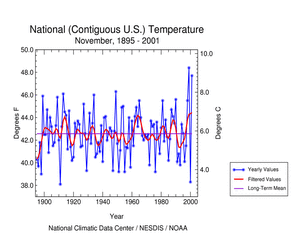
The graph to the left shows monthly mean temperature averaged across the contiguous United States based on long-term data from the U.S. Historical Climatology Network (USHCN). The 2001 value is estimated from preliminary Climate Division data using the first difference approach. November 2001 ranked as the second warmest November in the 1895 to present record. The preliminary nationally averaged temperature was 47.8° F (8.8° C) which was 5.2° F (2.9° C) above the long-term mean. The November temperature values from 1895 through 2001 are available. |
| It is interesting to note that November 1999 and November 2000 temperatures were the record warmest and second coldest, respectively. The Mean 500mb Height and Anomalies chart shows positive anomalies over the bulk of the country, with the greatest anomalies centered over the East North Central region, which were associated with above normal temperatures. A more detailed analysis including how statewide and regionwide temperatures compare to other years is available. |
 larger image |
Temperature Departures
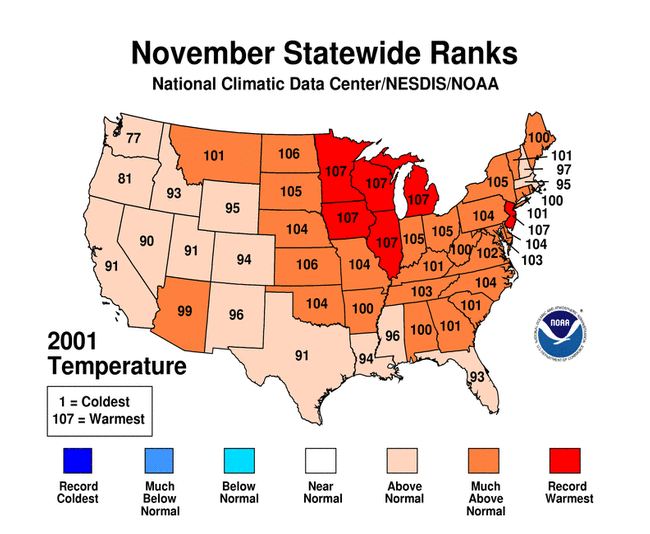
| The map to the right, based on approximately 250 airport stations, shows departures from the 1961-1990 normal temperatures for November 2001. Virtually the entire contiguous United States experienced positive temperature anomalies in November, with the largest anomalies of +9 ° F (+5° C) centered in the Midwest. Alaska was generally cooler than average while Puerto Rico and Hawaii were near normal. |  larger image |
 larger image |
The unusually warm departures of monthly mean temperature were associated with above normal persistence of daily temperatures. This is reflected in below normal day-to-day temperature variability across much of the nation, as seen both in the map to the left and in an animated map of daily temperature anomalies. |
National Precipitation
 larger image |
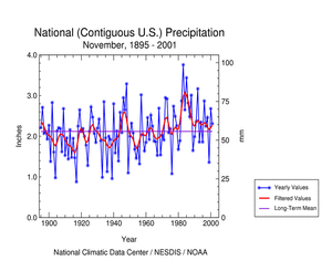
The graph to the left is a time series depicting precipitation averaged across the nation. Based upon preliminary precipitation data, November 2001 was above average, ranking thirty-sixth wettest in the 1895 to present record. While nationally averaged precipitation was above the long term mean, there was considerable regional variability. Delaware and Rhode Island were notably dry receiving much below normal precipitation for the month. |
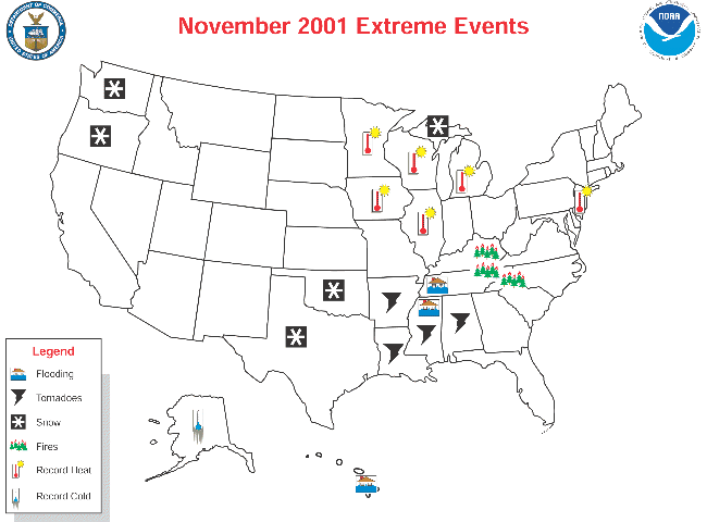
| A severe weather outbreak occurred on the 23rd and 24th affecting Arkansas, Louisiana, Mississippi and especially Alabama where the National Weather Service reported that more than 15 tornadoes may have touched down. On the 28th, ice, snow and wind gusts up to 85 mph (38 m/sec) battered the Pacific Northwest. That same day, a winter storm was blamed for 12 deaths as the first snowstorm of the season hammered the Southern Plains. The snowy weather caused hundreds of traffic accidents and thousands were without power. |  larger image |
The storm moved into the Lower Mississppi Valley on the 29th, bringing freezing rain to Arkansas and flooding to Mississippi and 8-14 inches (20-36 cm) of rain to Tennessee. Memphis had their third wettest November on record with 11.61 inches (29.5 cm) of rain.
A more detailed analysis including how statewide and regionwide temperatures compare to other years is available.
Precipitation Anomalies
| The map to the right, based on approximately 250 airport stations, shows November 2001 total precipitation as a percent of the 1961-1990 station normals. Above normal precipitation generally occurred in the West Coast states, New Mexico into Texas, the Northern Plains and in portions of the mid Mississippi River Valley. The rest of the country was mostly dry including Alaska. Conditions in Puerto Rico and Hawaii were normal to wet. |  larger image |
National Snow Cover
On November 29th, portions of Oklahoma and Texas were blanketed with snow and ice. Nine inches (23 cm) of snow fell in Aspermont, Texas and Chickasha and Shawnee, Oklahoma received around eight inches (20 cm) of snow. Icy weather caused traffic nightmares for travelers and forced many road and bridge closings. Marquette, Michigan received a record 9.2 inches (23.4 cm) of snowfall and parts of the Upper Peninsula received 8-14 inches (20-36 cm) of snow on the 26th.
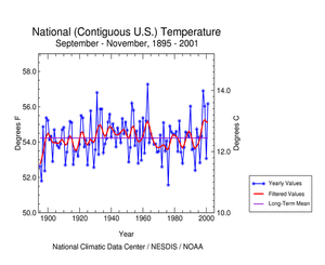
Fall Temperatures
 larger image |
The graph to the left shows seasonal mean temperature averaged across the contiguous United States based on long-term data from the U.S. Historical Climatology Network (USHCN). The 2001 value is estimated from preliminary Climate Division data using the first difference approach. Fall 2001 ranked as the fourth warmest fall in the 1895 to present record. The preliminary nationally averaged temperature was 56.4° F (13.6° C) which was 2.2° F (1.2° C) above the long-term mean. The fall temperature values from 1895 through 2001 are available. |
| Fall temperatures ranged from near normal in the South and East to record warm in the Southwest. Both Nevada and New Mexico experienced record warm falls. Alaska had a cooler than average fall. The fall temperature anomalies map shows where the largest positive anomalies occurred. A more detailed analysis including how statewide and regionwide temperatures compare to other years is available. |
 larger image |
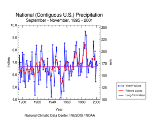
Fall Precipitation
 larger image |
The graph to the left is a time series depicting precipitation averaged across the nation. Based upon preliminary precipitation data, fall 2001 was near the long term mean.
|
| As with November, there was considerable regional variability. Delaware , New Jersey , and Virginia were record dry receiving much below normal precipitation for the season. The fall precipitation anomalies map shows where the largest anomalies occurred. A more detailed analysis including how statewide and regionwide temperatures compare to other years is available. |
 larger image |