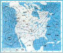
The North American 500 mb Maps for June
The sun is the primary source of earth's weather, by causing differential heating between the tropics and polar regions. This sets up a state of motion in which the atmosphere is always trying to balance itself: the warm air moves poleward in patterns called ridges, and the cooler air moves equatorward in patterns called troughs. In the mid-latitudes (30 to 60 degrees North and South) the rotation of the earth generally causes weather systems to move eastward.
This dynamic process is best seen on the 500-millibar chart. This chart shows the circulation of the atmosphere at roughly 18,000 feet (5486 meters) and is based on soundings taken by weather balloon on a twice-daily basis. These soundings are then plotted on a map and the lines of equal pressure are connected. Ridges extend toward the pole, are usually associated with warm, dry weather, and have the general shape of an upside down "U" in the Northern Hemisphere. Troughs extend toward the equator, are usually associated with cool, wet weather, and have the general shape of a "U" in the Northern Hemisphere. The area of greatest surface instability (thunderstorms) is usually immediately ahead of (to the right of) the 500 mb trough.
For the first two weeks of the month, the continental United States was dominated by an upper-level flow pattern which consisted of a trough in the west and a ridge in the east. The upper-level circulation during the last half of June shifted to a near normal pattern over the west and a stronger ridge in the east. This pattern resulted in cooler than normal temperatures along the Pacific Coast and near normal temperatures for the remainder of the country. Much warmer than normal conditions occurred in the Northeast.
| Near normal precipitation was observed from the west coast to the Rockies. Wetter than normal conditions dominated the central and southern Mississippi valley and the extreme southeast. The mid-Atlantic and Northeast portions of the country were much drier than normal. Additional information and maps can be found at the Hydrometeorological Prediction Center's Web Page.
|
larger image
|

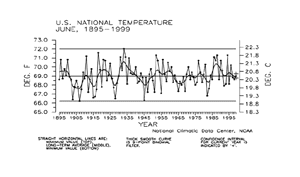
 National Temperature - June
| Preliminary data for June 1999 indicated that the monthly mean temperature averaged across the contiguous United States was near the long-term mean. About three percent of the country was much warmer than normal while less than one percent of the country was much cooler than normal.
|
larger image
|
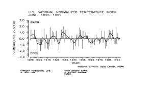
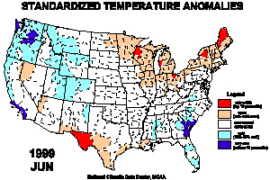
The national temperature index expresses temperature departure from the 60-year mean in terms of standard deviations. Each year's value is computed by standardizing the temperature for each of 344 climate divisions in the U.S. by using their 1931-90 mean and standard deviation, then weighting these divisional values by area.
| These area-weighted values are then normalized over the period of record. Positive values indicate warmer than the mean and negative values indicate cooler than the mean. The preliminary June 1999 national standardized temperature index also averaged near the long-term mean.
|
larger image
|
larger image
|
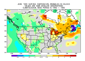
A ridge of high pressure kept eastern North America (around the Canadian - U.S. border) warmer than usual. This warmth stretched to the landmass surrounding the Hudson Bay. A storm track and transient trough near the center of the continent brought unusually cool temperatures. A persistent trough over western Canada and the U.S. Pacific Northwest kept this region cooler than usual. Clouds and rain kept the southern plains and northern Mexico cooler than average and this rain was much needed in Mexico.
|
Rain clouds also brought unusually cool temperatures to Florida. The cold bulls-eye in the Gulf of the St. Lawrence is erroneous, and efforts are under to correct the analysis where there is partial sea ice. The temperature anomaly map above is based on a blend of surface station data and satellite data.
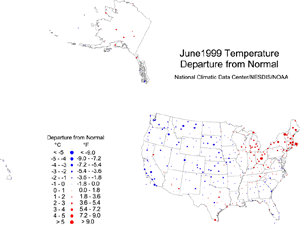
| The map to the right, based on approximately 250 airport stations, shows June 1999 average temperatures as a departure from 1961-1990 station normals. The pattern of blue dots (cold temperature departures) in the western half of the country and red dots (warm temperature departures) in the northeastern quarter of the country is consistent with the June circulation pattern. Parts of the southeastern U.S. averaged cooler than normal due to unusual cloudiness which also brought wet conditions to much of the region. June 1999 averaged near to slightly warmer than normal over much of Alaska and near to slightly cooler than normal over the Hawaiian stations.
|
larger image
|
larger image
|
The map animation to the left shows the geographical pattern of temperature anomalies for the last 12 months, compared to a base period of 1931-1990. On these standardized temperature anomaly maps, the color scheme ranges from blue (cold) to red (warm):
red = top 10 percentile
tan = 70-90 percentile
light blue = 10-30 percentile
dark blue = bottom 10 percentile.
|
Temperature Variability
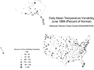
Monthly mean temperature maps show the average conditions during a month, but give no information about changes that occurred within the month. A measure of the day-to-day variability of temperature provides some insight into how temperatures changed during the month. Daily temperature variability is highly dependent on the weather systems and air masses that affect a region.
The daily difference in temperature may be lower in areas where a single air mass remains dominant. This can happen under a stable circulation pattern (at the jet stream level) that locks an air mass in place--for example, a strong zonal flow, or a stable ridge/trough pattern. The daily difference in temperature will be higher in areas that experience a greater frequency of frontal passages as cold arctic air moves southward and warmer, maritime air moves northward. This will happen under a variable circulation pattern, or along a stable storm track.
To quantify the variability in daily temperature, the average daily differences in temperature for the current month have been expressed as a ratio of the normal (1961-90) average daily difference. The magnitude of this ratio is expressed by the size of the dot representing the value at each of approximately 250 First Order airport stations across the United States. Small dots indicate that daily variability in temperature was less than normal, and may be a consequence of a dominant air mass. Large dots indicate that daily temperature variability was greater than normal reflecting a more frequent passage of differing air masses.
larger image
|
Daily temperature variability for June 1999 showed a less organized spatial pattern than in earlier seasons. This is typical for temperature variability in the summer months.
|
National Precipitation - June
larger image
|
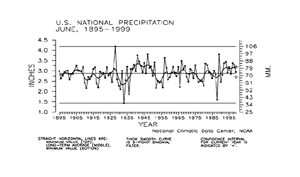
Based upon preliminary data, June 1999 precipitation averaged near the long-term mean. Over four percent of the country was much wetter than normal while about seven percent of the country was much drier than normal.
|
The national precipitation index expresses precipitation departure from the 60-year mean in terms of standard deviations. Each year's value is computed by standardizing the annual precipitation in each of 344 climate divisions across the U.S. using the gamma distribution over the 1931-90 period. The gamma statistical distribution takes into account heavy precipitation years and extremely dry years in the historical record (in mathematical parlance, "a zero-bounded skewed distribution"). These gamma-standardized divisional values are then weighted by area and averaged to determine a national standardized value for each year.
| These national values are normalized over the period of record. Negative values are drier and positive values are wetter than the mean. This index gives a more accurate indication of how precipitation across the country compares to the local normal (60-year average) climate.
|
The preliminary national standardized precipitation index for June 1999 averaged near the long-term mean.
larger image
|
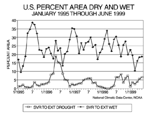
Long-term drought coverage (as measured by the Palmer Drought Index) was up slightly over May, with June 1999 having about seven percent of the country in severe to extreme drought. The percent area of the country experiencing severe to extreme wetness increased slightly to about 19%.
|
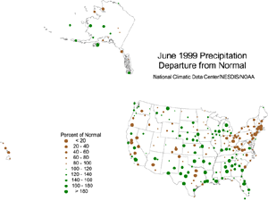
The map immediately below, based on approximately 250 First Order airport stations, shows June 1999 total precipitation as a departure from 1961-1990 station normals.
| The departure map, in general, shows the less coherent spatial pattern characteristic of summertime precipitation. However, certain areas do stand out. For example, the Northeast to Ohio Valley was unusually dry during June, and unusually wet conditions occurred over much of the Southeast and southern and central Plains. Stations in southwestern Alaska had above-normal precipitation, while the Hawaiian stations were drier than normal.
|
larger image
|
Drought Indices and Wetness Anomalies
The Palmer Z Index shows how monthly moisture conditions depart from normal (short-term drought and wetness). The animated maps show the geographical pattern of the moisture anomalies for the last 12 months. On these maps, the red shading denotes dry conditions while the green shading indicates wet conditions.
|
larger image
|
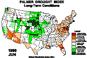
The Palmer Drought Index Maps show long-term (cumulative) drought and wet conditions. The unusually dry conditions in June caused drought to expand and intensify in the northeastern U.S., while a wet June in the Southeast brought drought relief to that region. Long-term drought continued in parts of the Southwest. Much of the northern and central Plains and central Rockies continued in long-term wet spell conditions. The animated maps show how the geographical pattern of the long-term moisture conditions has changed over the last 12 months. On these maps, the red shading denotes drought conditions while the green shading indicates wet conditions.
|
| The Palmer Crop Moisture Index is computed on a weekly basis by the National Weather Service's Climate Prediction Center and is useful for following the impact of precipitation anomalies on agriculture. The Animated Crop Moisture Index maps show the change in topsoil moisture conditions during the first 26 weeks of 1999. On these Crop Moisture Index maps, the red shading denotes dry conditions while the green shading indicates wet conditions.
|
larger image
|
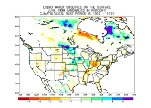
The positive anomalies in northeastern Canada, on the map to the left, corresponds to an area where the snow cover persisted longer than normal, extending through May and melting in June. This was also true west of the Hudson Bay. In contrast, south of Hudson Bay temperatures in May were warmer than usual, causing the snow cover to melt prematurely and leaving the area drier than average in June.
|
Positive wetness anomalies covered much of the U.S. plains and Midwestern states, an area where the predominant storm track brought excessive rainfall. Further west over portions of the high plains, the surface was drier than usual. High pressure over the portions of the Ohio Valley and northeastern states supressed precipitation. Most of the eastern U.S. was drier than normal and these dry conditions were most pronounced in the northeastern portion of the country. These dry conditions are not accurately depicted in this image, since dense vegetation obscures the surface water from the satellite.
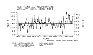
National Temperature - January-June
larger image
|
Preliminary temperature data indicate that the year-to-date, January-June 1999, was the ninth warmest January-June period since records began in 1895. About 19% of the country averaged much warmer than normal while near zero percent of the country averaged much cooler than normal.
|
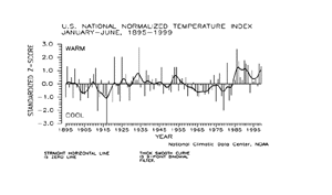
| The preliminary national standardized temperature index ranked January-June 1999 as the 11th warmest January-June on record.
|
larger image
|
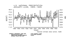
National Precipitation - January-June
larger image
|
Preliminary precipitation data indicate that the year-to-date, January-June 1999, ranked near the long-term mean for nationally averaged precipitation summed across the six months. About five percent of the country was much wetter than normal for this period while about two percent of the country averaged much drier than normal.
|
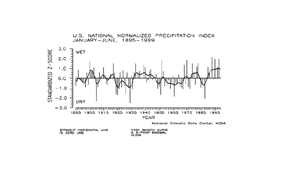
| The prelimininary national standardized precipitation index for January-June 1999 also ranked near the long-term mean.
|
larger image
|
Tornadoes - June and Year-to-date
larger image
|
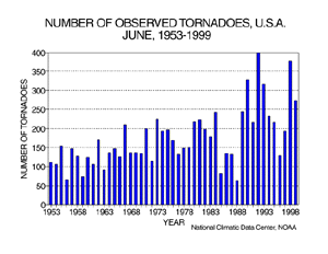
During June 1999, 273 tornadoes were documented across the contiguous United States, ranking the month as the fifth most active June since 1953. The 46-year average is 173. The most tornadoes observed in the June record was 400 in June 1992, while the least amount was 63 in June 1988.
|
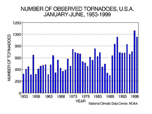
| For the year-to-date, January-June 1999, 955 tornadoes have been documented. This ranks as the third most active year-to-date, behind the count of 956 recorded in 1991. The most tornadoes observed during this same six-month period is 1061 in 1998 while the least amount was 302 in 1988.
|
larger image
|
It should be pointed out that the preliminary tornado count is traditionally higher than the final count and that the tornado observations have generally improved with time as better observing practices and instrumentation (especially weather radar and satellites) were utilized.
Current data are based on preliminary reports from River Forecast Center stations and First and Second Order airport stations obtained from the National Weather Service (NWS) Climate Prediction Center and real time Global Telecommunications System (GTS) monthly CLIMAT summaries. THE CURRENT DATA SHOULD BE USED WITH CAUTION. These preliminary data are useful for estimating how current anomalies compare to the historical record, however the actual values and rankings for the current year may change as the final data arrive at NCDC and are processed.
The following NCDC datasets are used for the historical U.S. data: the climate division drought database (TD-9640), and the hurricane datasets (TD-9636 and TD-9697). It should be noted that the climate division drought database consists of monthly data for 344 climate divisions in the contiguous United States. These divisional values are calculated from the 6000+ station Cooperative Observer network.


