Temperature
NOAA's National Centers for Environmental Information calculates the global temperature anomaly every month based on preliminary data generated from authoritative datasets of temperature observations from around the globe. The major dataset, NOAAGlobalTemp version 5, updated in mid-2019, uses comprehensive data collections of increased global area coverage over both land and ocean surfaces. NOAAGlobalTempv5 is a reconstructed dataset, meaning that the entire period of record is recalculated each month with new data. Based on those new calculations, the new historical data can bring about updates to previously reported values. These factors, together, mean that calculations from the past may be superseded by the most recent data and can affect the numbers reported in the monthly climate reports. The most current reconstruction analysis is always considered the most representative and precise of the climate system, and it is publicly available through Climate at a Glance.
October 2022
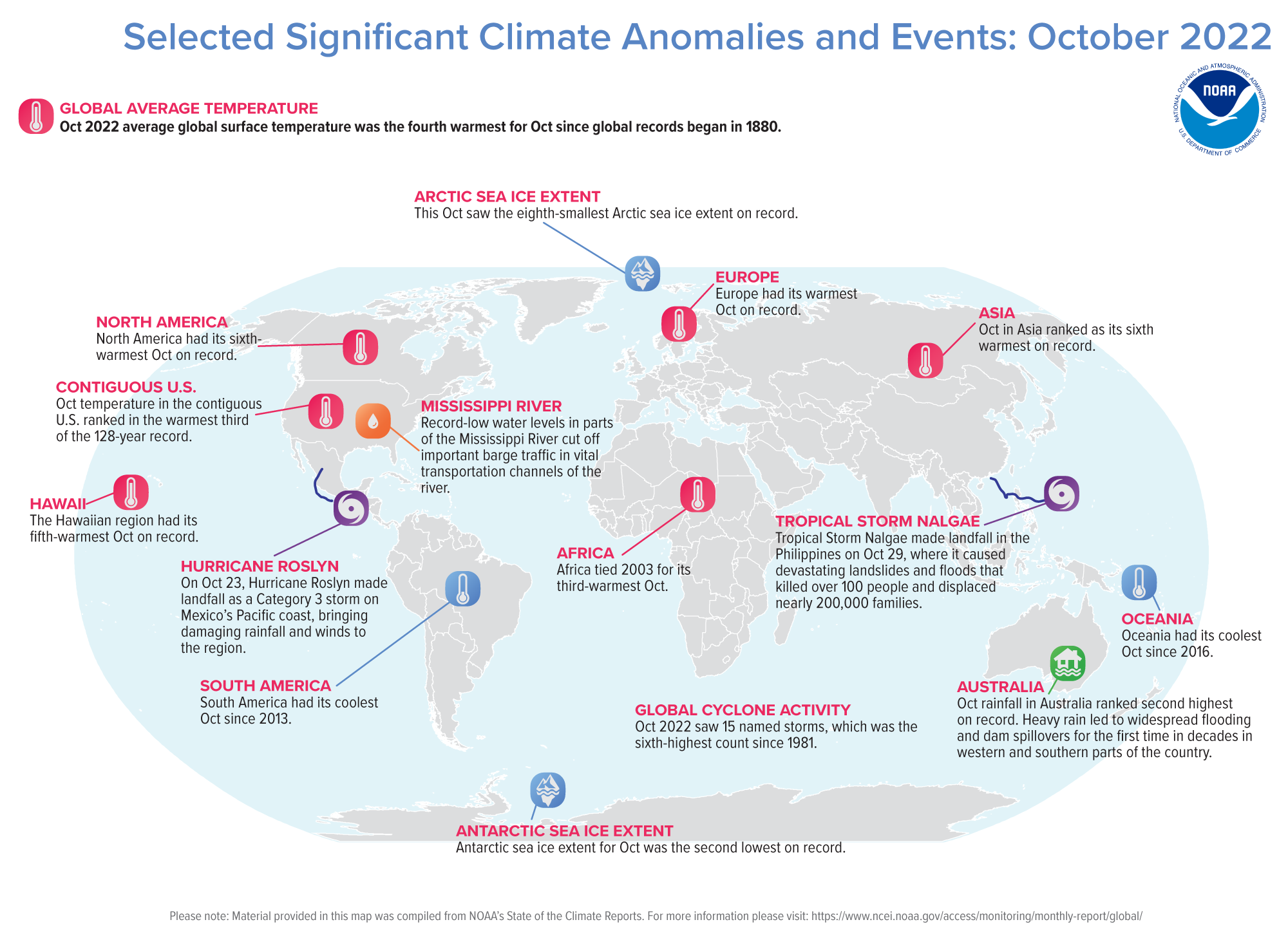
October 2022 was the fourth-warmest October in NOAA's 143-year record. The October global surface temperature was 1.60°F (0.89°C) above the 20th-century average of 57.1°F (14.0°C). The past seven Octobers were among the ten warmest Octobers on record. October 2022 marked the 46th consecutive October and the 454th consecutive month with temperatures, at least nominally, above the 20th-century average.

Warmer-than-average conditions were observed across most of Europe, northern and western North America, northern Asia, northwestern, eastern, and southern Africa, and across parts of northern Oceania and southern and western Asia. Parts of western and central Europe, western North America, and Africa experienced record-high October temperatures. Sea surface temperatures were above average across much of the Atlantic, the northern, western, and southwestern Pacific, and the Mediterranean Sea, as well as parts of the eastern Indian Ocean. Overall, record-warm October temperatures encompassed about 7.2% of the world's surface.
The unusually warm temperatures across much of the Northern Hemisphere (NH) land resulted in the warmest NH October land temperatures on record, surpassing the previous record set in 2021 by 0.03°C (0.05°F). Combined with ocean temperatures, the NH overall temperature for October was the second-warmest on record after 2015. The 2015 record is just 0.02°C (0.04°F) above this month's combined NH land and ocean temperature.
Temperatures were near- to cooler-than-average across parts of southeastern North America, central South America, eastern parts of central Asia, and southern Oceania. The Gulf of Mexico, the central, eastern tropical, and southeastern Pacific Ocean, and parts of the western Indian Ocean experienced near- to cooler-than-average sea surface temperatures. However, there were no areas with record-cold October temperatures this month.


Europe had its warmest October on record at 2.6°C (4.6°F) above the 1910-2000 average. This surpassed the previous record, set in 2020, by 0.38°C (0.68°F). More than seven countries in Europe recorded their warmest or joint-warmest October on record.
- Austria had its warmest October on record. Austria's national weather service reported that the average temperature was 2.8°C above the 1991-2020 baseline in the lowlands, and 4.0°C warmer in the mountains.
- According to MeteoSwiss, Switzerland had its warmest October since the country began its records in 1865, with an average temperature 3.7°C above the 1991-2020 average.
- Belgium tied 2001 for its warmest October on record, 3.1°C warmer than the 1991-2020 average, according to Belgium's Royal Meteorological Institute.
- MeteoFrance reported that France had its warmest October since records began in 1945, about 3.5°C above the 1991-2020 normal.
- Spain recorded its warmest October since records began in 1961.
- Germany tied 2001 for its warmest October on record according to the German Meteorological Service.
- As reported by MeteoLux, October in Luxembourg tied a 2006 record for the warmest on record at 2.9°C above the 1991-2020 average.
- According to the Ministry of the Environment and Space, Slovenia had its warmest October since at least 1950 at 3.2°C above the 1981-2010 average.
- The Danish Meteorological Institute reported that at 2.3°C above the 1991-2020 average, Denmark had its fourth warmest October since measurements began in 1874.
- The United Kingdom had an October that was 1.8°C above average and the seventh warmest on record.
- The Netherlands had its sixth-warmest October on record according to the Royal Netherlands Meteorological Institute.
Africa tied 2003 for its third-warmest October on record, after the Octobers of 2015 and 2016. North America and Asia each had their sixth-warmest October.
- Hong Kong had its eighth-warmest October on record.
- The contiguous U.S. had an average temperature 1.2°F above average, which ranked in the warmest third of the historical record.
- Much of British Columbia experienced an extended summer this October, where more than ten stations across the province recorded their warmest October on record.
Oceania and South America each had a warmer-than-average October, but it did not rank among their top ten on record.
- Oceania had its coolest October since 2016.
- New Zealand had a near-average October temperature this month.
- Australia also had a near-average October temperature, just 0.19°C above the 1961-1990 average.
- South America had its coolest October since 2013.
| October | Anomaly | Rank (out of 143 years) | Records | ||||
|---|---|---|---|---|---|---|---|
| °C | °F | Year(s) | °C | °F | |||
| Global | |||||||
| Land | +1.42 ± 0.18 | +2.56 ± 0.32 | Warmest | 2nd | 2015 | +1.47 | +2.65 |
| Coolest | 142nd | 1912 | -0.93 | -1.67 | |||
| Ocean | +0.70 ± 0.15 | +1.26 ± 0.27 | Warmest | 5th | 2015 | +0.87 | +1.57 |
| Coolest | 139th | 1908 | -0.48 | -0.86 | |||
| Ties: 2017, 2021 | |||||||
| Land and Ocean | +0.89 ± 0.15 | +1.60 ± 0.27 | Warmest | 4th | 2015 | +1.03 | +1.85 |
| Coolest | 140th | 1912 | -0.54 | -0.97 | |||
| Northern Hemisphere | |||||||
| Land | +1.55 ± 0.19 | +2.79 ± 0.34 | Warmest | 1st | 2022 | +1.55 | +2.79 |
| Coolest | 143rd | 1912 | -1.26 | -2.27 | |||
| Ocean | +0.96 ± 0.15 | +1.73 ± 0.27 | Warmest | 4th | 2015 | +1.09 | +1.96 |
| Coolest | 140th | 1892 | -0.54 | -0.97 | |||
| Land and Ocean | +1.18 ± 0.21 | +2.12 ± 0.38 | Warmest | 2nd | 2015 | +1.20 | +2.16 |
| Coolest | 142nd | 1912 | -0.78 | -1.40 | |||
| Southern Hemisphere | |||||||
| Land | +1.08 ± 0.15 | +1.94 ± 0.27 | Warmest | 10th | 2015 | +1.68 | +3.02 |
| Coolest | 134th | 1880 | -0.91 | -1.64 | |||
| Ocean | +0.51 ± 0.15 | +0.92 ± 0.27 | Warmest | 10th | 2015 | +0.70 | +1.26 |
| Coolest | 134th | 1903 | -0.45 | -0.81 | |||
| Ties: 2014 | |||||||
| Land and Ocean | +0.60 ± 0.14 | +1.08 ± 0.25 | Warmest | 10th | 2015 | +0.86 | +1.55 |
| Coolest | 134th | 1903, 1910 | -0.47 | -0.85 | |||
| Arctic | |||||||
| Land and Ocean | +2.00 ± 0.53 | +3.60 ± 0.95 | Warmest | 3rd | 2018 | +2.31 | +4.16 |
| Coolest | 141st | 1912 | -1.52 | -2.74 | |||
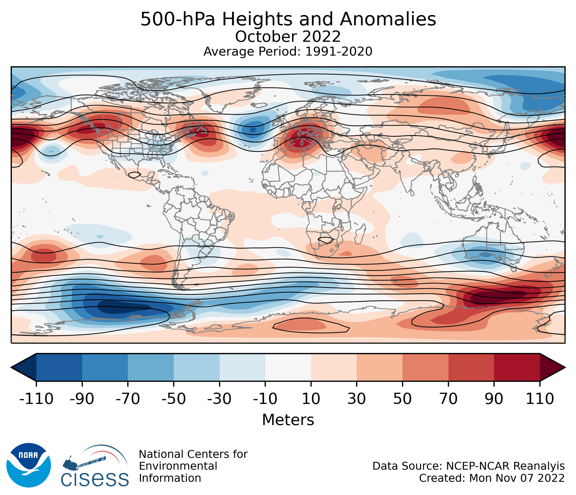
500 mb maps
In the atmosphere, 500-millibar height pressure anomalies correlate well with temperatures at the Earth's surface. The average position of the upper-level ridges of high pressure and troughs of low pressure—depicted by positive and negative 500-millibar height anomalies on the September 2022 map—is generally reflected by areas of positive and negative temperature anomalies at the surface, respectively.
Year-to-date Temperature: January–October 2022
January to October was characterized by warmer-than-average conditions across much of North America, Europe, Asia, northern and southern Africa, northern Oceania, and central and eastern South America. Much of the Atlantic and northern and western Pacific oceans, and parts of the eastern Indian Ocean, had warmer-than-average year-to-date temperatures. The January–October Northern Hemisphere land and ocean temperature ranked fourth warmest on record.
Meanwhile, near- to cooler-than-average conditions were present across small parts of north-central North America, central Saharan Africa, and western South America. Consistent with La Niña patterns, the central and eastern tropical Pacific Ocean and the southeastern Pacific Ocean experienced cooler-than-average year-to-date conditions.
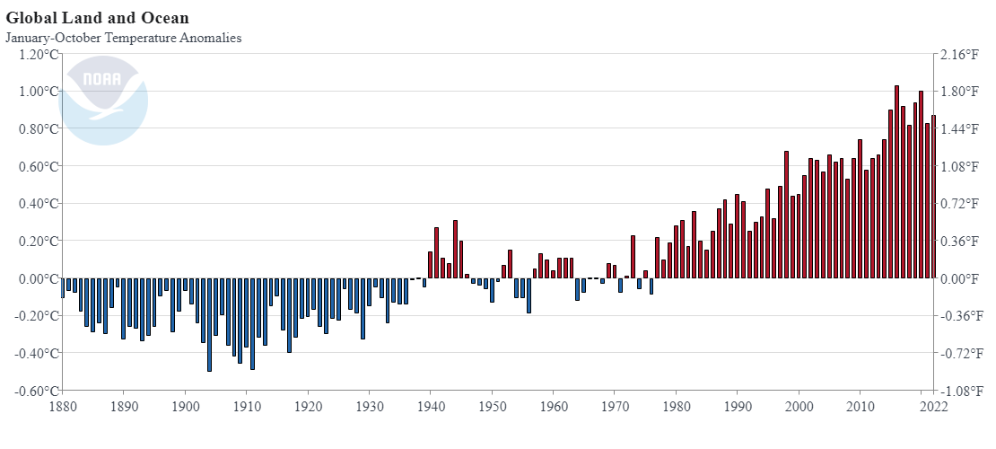
The January–October global surface temperature was 0.87°C (1.57°F) above the 1901-2000 average of 14.1°C (57.4°F) — the sixth-highest January–October temperature in the 143-year record. The ten warmest January–October periods on record have occurred since 2010. According to NCEI's statistical analysis, the year 2022 is very likely to rank among the ten warmest years on record but a less than 2% chance to rank among the five warmest years on record.


Asia had its second-warmest January–October period on record after 2020. Europe followed closely behind, with its January–October period ranking third warmest on record. The Caribbean Islands had their eighth-warmest year-to-date, while the Gulf of Mexico had its tenth-warmest. Africa and North America each had their 11th-warmest year-to-date. Oceania and South America each had a year-to-date period that ranked among the top twenty warmest on record.
| January–October | Anomaly | Rank (out of 143 years) | Records | ||||
|---|---|---|---|---|---|---|---|
| °C | °F | Year(s) | °C | °F | |||
| Global | |||||||
| Land | +1.35 ± 0.18 | +2.43 ± 0.32 | Warmest | 6th | 2016, 2020 | +1.59 | +2.86 |
| Coolest | 138th | 1884 | -0.70 | -1.26 | |||
| Ocean | +0.69 ± 0.18 | +1.24 ± 0.32 | Warmest | 6th | 2016 | +0.82 | +1.48 |
| Coolest | 138th | 1904 | -0.48 | -0.86 | |||
| Land and Ocean | +0.87 ± 0.17 | +1.57 ± 0.31 | Warmest | 6th | 2016 | +1.03 | +1.85 |
| Coolest | 138th | 1904 | -0.50 | -0.90 | |||
| Northern Hemisphere | |||||||
| Land | +1.52 ± 0.21 | +2.74 ± 0.38 | Warmest | 3rd | 2016 | +1.76 | +3.17 |
| Coolest | 141st | 1884 | -0.80 | -1.44 | |||
| Ocean | +0.87 ± 0.17 | +1.57 ± 0.31 | Warmest | 5th | 2020 | +1.00 | +1.80 |
| Coolest | 139th | 1904 | -0.52 | -0.94 | |||
| Ties: 2017 | |||||||
| Land and Ocean | +1.12 ± 0.18 | +2.02 ± 0.32 | Warmest | 4th | 2020 | +1.28 | +2.30 |
| Coolest | 140th | 1904 | -0.54 | -0.97 | |||
| Ties: 2017 | |||||||
| Southern Hemisphere | |||||||
| Land | +0.92 ± 0.13 | +1.66 ± 0.23 | Warmest | 11th | 2019 | +1.28 | +2.30 |
| Coolest | 133rd | 1917 | -0.76 | -1.37 | |||
| Ocean | +0.56 ± 0.18 | +1.01 ± 0.32 | Warmest | 7th | 2016 | +0.72 | +1.30 |
| Coolest | 137th | 1911 | -0.47 | -0.85 | |||
| Ties: 1998 | |||||||
| Land and Ocean | +0.61 ± 0.17 | +1.10 ± 0.31 | Warmest | 8th | 2016 | +0.79 | +1.42 |
| Coolest | 136th | 1911 | -0.50 | -0.90 | |||
| Arctic | |||||||
| Land and Ocean | +1.77 ± 0.12 | +3.19 ± 0.22 | Warmest | 5th | 2016 | +2.48 | +4.46 |
| Coolest | 139th | 1902 | -1.21 | -2.18 | |||
Precipitation
The maps shown below represent precipitation percent of normal (left, using a base period of 1961–1990) and precipitation percentiles (right, using the period of record) based on the GHCN dataset of land surface stations.
October 2022
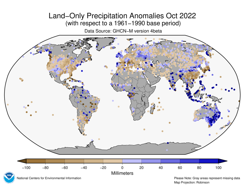
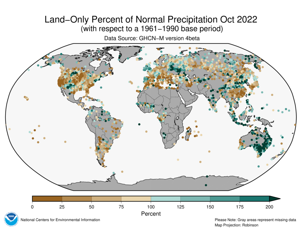
October precipitation was generally less than normal across the western, central, and southeastern U.S., southern Europe, central Asia, southern South America, as well as across parts of southeast China and southwestern Asia. Wetter-than-normal conditions were notable across parts of northern Europe, southern parts of central Asia, central India, northern Oceania, and eastern Australia.
Global Precipitation Climatology Project (GPCP)
The following analysis is based upon the Global Precipitation Climatology Project (GPCP) Interim Climate Data Record. It is provided courtesy of the GPCP Principal Investigator team at the University of Maryland.
October Highlights:
- The long-running (since 2020) La Niña provided background conditions for floods in Australia, South Asia and the Maritime Continent, and West Africa.
- Precipitation deficits dominated North America (except for Arizona and New Mexico), which continued drought over large areas and low flow in the Mississippi River.
- Western Europe reverted to rainfall deficits for October, endured a heat wave, and had its drought reinforced.
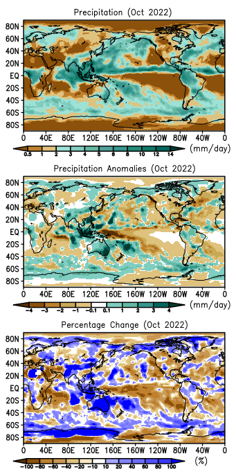
The current multi-year La Niña provided significant forcing over most of the tropical Pacific Ocean and surrounding areas, which affected precipitation patterns for the month superimposed on the usual climatological transitions into the fall/spring seasons. Other factors and normal weather variations added to the monthly maps. The figure to the left shows the mean precipitation for the past month along with the deviations from the long-term (1979-2021) climatology in terms of magnitude and percentage. This transition month had the rainfall maximum over South Asia slipping toward the south, with northern Australia still dry. The Intertropical Convergence Zone (ITCZ) stretched across the Pacific and Atlantic and broader rainfall features across northern South America and central Africa. At higher latitudes, the dry zones of the sub-tropics were evident centered about at latitude 20° with storm tracks and their associated mean precipitation further poleward.
The middle and bottom panels in the figure to the left show the deviations from climatology for this October with broad dry and wet (compared to normal) areas with superimposed. Smaller-scale features were associated with weather-scale occurrences during the month. As has been the case over the last two plus years, the ongoing La Niña, with its below normal sea surface temperatures over the central Pacific Equatorial zone, affected the precipitation anomaly distribution in the tropics and beyond. That point is obvious when examining the figure below, which shows a La Niña composite for October, i.e., a mean anomaly map for past La Niñas during October. By comparing that La Niña composite with the anomaly map for this past month, one can see obvious similarities, especially centered on the tropical Pacific, but also places where features do not match. An intense dry zone appears in both panels of the figure below across the equatorial Pacific where the cooler-than-normal sea surface temperatures are located. A dry zone extension from the equator to the southeast across the South Pacific in both panels is notable, even extending across South America and into the South Atlantic. Above the equator, the anomaly patterns in the two panels have some, but weaker agreement. As is typical of La Niña conditions, to the west of the equatorial dry area a region of generally wetter-than-normal conditions exists over the Maritime Continent (Java, etc.) and the surrounding waters, with an extension over Australia. In fact, a generally wetter-than-normal zone extends east-southeastward from Australia across the South Pacific through the Magellan Strait—in both this month's anomalies and in the composite. A little further out, both maps show a rainfall deficit over east Africa.
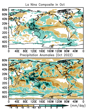
The effect of the La Niña-related circulation anomalies was therefore obvious, at least for regions close to the core of the phenomenon (the central Equatorial Pacific) and somewhat beyond. This large-scale circulation effect, however, has the ability to provide a base for smaller-scale, weather-based precipitation effects. The best example for this in October was the Maritime Continent and Australia. The multiple intense positive anomalies this month over that area were associated with storms or multiple storms enhanced or supplemented by the La Niña Effect. Although the composite has generally positive anomalies over most of Australia (in the middle of the dry season), the very intense wet feature in southeast Australia was associated with devastating floods there during the month in the states of New South Wales, Victoria and Tasmania. These October floods in Australia were the fifth episode of serious floods there over the last 19 months, another correlation with long-running La Niña conditions. Other intense features over the general Maritime Continent positive anomaly were related to floods this month in Indonesia, Cambodia, Bangladesh, and the Philippine Islands, some associated with tropical cyclone activity. Over tropical Africa, especially west Africa, the flooding that occurred in previous months continued to a degree, with additional flooding in Chad, Benin, Cameroon and (especially) Nigeria.
On the other hand, the tropical Atlantic this October was relatively dry, in terms of rainfall. This is the opposite of what is expected under La Niña conditions, which usually are associated with increased hurricane activity and rainfall.
North America was almost totally covered with less-than-normal precipitation this month, partly related to the La Niña. This relative lack of precipitation continued from the preceding months, and has led to worsening drought conditions over large areas of the U.S. including very low flow in the Mississippi River. One area in the U.S. West was spared and had an above-average rainfall total; this area was in the southwest, centered in Arizona and New Mexico. Western Europe faced another area of continued drought and endured a heat wave during the month. This region was part of broad area of negative rainfall anomalies running from the tropical Atlantic into western and central Europe and, with an interruption, across northern Eurasia. At high latitudes, positive precipitation anomalies stretch across Scandinavia and the northern edge of Asia and into Alaska.
Drought in October 2022
Drought information is based on global drought indicators available at the Global Drought Information System website, and media reports summarized by the National Drought Mitigation Center.
October Highlights: Beneficial precipitation returned to parts of Europe, but October 2022 continued dry over the agricultural lands of Africa, the Americas, and eastern China, and much of the world's agricultural lands were still suffering from low soil moisture and groundwater levels, with evaporative stress high for this time of year. These areas include the Canadian Prairies, Great Plains of the United States, Brazil and Argentina in South America, Western Europe, southeast China, and East Africa. Of the continents, Australia seemed to be in the best shape.
Europe was warmer than normal in October. Western and northern parts of Europe were wetter than normal, but central to southern and eastern parts were drier than normal. These factors combined to enhance stress from evapotranspiration across most of Europe. The October and September rains helped reduce short-term deficits, but longer-term precipitation deficits were still evident as seen in Standardized Precipitation Index (SPI) and Standardized Precipitation Evapotranspiration Index (SPEI) values at the 6-month to 24-month time scales. With soil moisture still depleted, the European Combined Drought Indicator showed areas of drought throughout Europe. According to media reports, Europe's drought resulted in losses of more than EUR 1 billion for agriculture in Romania. England's The Guardian reported that farmers warn that if drought persists through next summer as predicted, they will not be able to grow crops as reservoirs remain empty. Drought could possibly lead to the collapse of the fruit and vegetable supply chain.
Northern and western parts of Asia, and much of China, were warmer than normal during October, while southeast China and parts of central Asia were drier than normal. The combination of warmer- and drier-than-normal conditions enhanced evapotranspiration, as seen in the 1-month SPEI and Evaporative Stress Index (ESI), over southeast China, central Asia, and Southwest Asia. Short-term precipitation deficits out to the last 3 months plagued southeast China and central to western Asia; longer-term deficits were evident in central Asia at the 6- to 12-month time scales; and precipitation deficits were seen across Southwest Asia at time scales spanning the last 6 to 36 months and longer. These areas were experiencing low soil moisture and groundwater levels, according to satellite observations. Unusually warm temperatures for the last several years combined with deficient precipitation to show drought stress in the SPEI indicator at the 1-month to 48-month time scales, and stressed vegetation based on the Vegetation Health Index (VHI), across large parts of northern, central, western, and southwestern Asia. According to media reports, heat and drought have depleted eastern Turkey's Lake Van, exposing thousand-year-old stalagmites, also referred to as "underwater fairy chimneys." Severe saltwater intrusion in Shanghai, China, threatened the drinking water supply, reported Caixin.
Parts of western Africa received precipitation during October, but eastern and some southern parts were drier than normal. Temperatures were warmer than normal in eastern, southern, and western Africa. The combination of warm and dry conditions, with high evaporative stress, resulted in SPEI values reflecting drought in these areas. Soil moisture was dry and groundwater levels were low, especially in central to eastern Africa, and vegetation was stressed in parts of eastern and southern Africa. Dry conditions were evident in the SPI over eastern Africa for the last 1 month to 2 years. When persistently warmer-than-normal temperatures are included, drought is more widespread over longer periods (out to the last 4 years) in the SPEI indicator. According to media reports, weak, starving cattle are being sold in Kenya as their Maasai owners try to keep the livestock alive during severe drought. Drought in Kenya has caused the deaths of 205 elephants and scores of other wildlife between February and October, as food and water sources were limited for the wildlife. Kenya, and neighboring countries Ethiopia and Somalia, are enduring the worst drought in 40 years. Four straight rainy seasons have failed to bring rain, which has devastated livestock and crops in some regions. As noted by Oxfarm, one person is likely to die of hunger every 36 seconds between now and the end of the year in drought-stricken East Africa as the worst hit areas hurtle towards famine. Water is being rationed in Dar es Salaam, the capital of Tanzania, after a drought-induced drop in water levels from its main source, the Ruvu river.
As in September, most of Australia was wetter and near to cooler than normal in October. Parts of northern Australia were warmer than normal, and the SPEI reflected lingering drought here with some evaporative stress. But the rain has replenished soil moisture and groundwater levels, and ended drought across most of the country, with drought reflected in northern portions at 6- to 12-month time scales on Australian Bureau of Meteorology Combined Drought Indicator analyses.
Rain fell across some of the drought areas in South America again during October, but other areas were drier than normal. Temperatures were warmer than normal over the northern half of the continent but near normal to the south. The rain was not enough to overcome precipitation deficits that have built up over the last several months, so areas of drought were evident in the SPI indicator across Brazil, Bolivia, and Peru and areas south at the 3- to 12-month time scales. Above-normal temperatures enhanced evapotranspiration and contributed to drought conditions over this period, as seen in the SPEI and ESI indicators. Satellite-based indicators showed dry soils, low groundwater, and stressed vegetation persisting in the drought areas. Drought in southern and eastern Brazil was confirmed on the Northeast Brazil Drought Monitor. According to media reports, the Rosario grains exchange noted that Argentina corn planting is progressing at its slowest pace in six years due to the protracted drought, and Argentina's 2022-23 wheat harvest is projected to be 13.7 million tons, sharply lower than its previous forecast of 15 million tons as drought harmed the crop. A lack of rain has slowed soybean planting in Argentina's main farm belt region. The ongoing drought, related to a third consecutive La Niña, has hurt wheat production and threatens to affect the upcoming soy and corn season. An agricultural emergency is currently in force in Uruguay due to the water and fodder deficit, which threatens the economy of the South American country weighted heavily on livestock and agriculture.
In North America, October was warmer than normal across the western U.S. and most of Canada, with drier-than-normal conditions across the U.S. west coast, central and eastern parts of the U.S., and areas across Canada. Evaporative stress was high across much of the continent, with soils continuing to dry out and groundwater levels low in the western and central U.S. and across western Canada. Precipitation deficits persisted across much of these areas as seen in the 2- to 12-month SPI values. Persistently warmer-than-normal temperatures have enhanced evapotranspiration and exacerbated drought conditions, as seen in the corresponding SPEI. Dry conditions on the SPEI extended into Mexico at the 6- to 12-month time scales. Satellite observations (VHI) show stressed vegetation across much of the western to central U.S.
The North American Drought Monitor product depicted drought over parts of eastern Mexico, much of the U.S., and across large parts of western Canada. Over 85% of the contiguous U.S. was experiencing drought or abnormal dryness at the end of October, which is a record in the 23-year history of the U.S. Drought Monitor. Dozens of large wildfires burned in the northwestern U.S., reservoirs were low in many parts of the western U.S., ponds and wells were going dry in the central U.S., and the Mississippi and Ohio Rivers reached record low levels, halting barge traffic. According to media reports, in Canada, Vancouver residents were asked to conserve as water use was high, while reservoir levels were low. The water level is so low at Chapman Lake, British Columbia, that it can't supply enough water through a nearby irrigation channel so crews were using helicopters to get water from the middle of the lake. In British Columbia, the Sunshine Coast Regional District, District of Sechelt and shíshálh Nation declared a state of local emergency as the system that supplies water to about 90% of the homes and businesses in the Sechelt area was at "imminent risk" of running dry. Soil moisture conditions in western Saskatchewan are far worse than they were in the Dirty Thirties, according to the president of the Saskatchewan Stock Growers Association. Precipitation in Swift Current so far in 2022 is 11.8 inches (300 mm) below average, twice as bad as the worst year in the 1930s.
References
- Adler, R., G. Gu, M. Sapiano, J. Wang, G. Huffman 2017. Global Precipitation: Means, Variations and Trends During the Satellite Era (1979-2014). Surveys in Geophysics 38: 679-699, doi:10.1007/s10712-017-9416-4
- Adler, R., M. Sapiano, G. Huffman, J. Wang, G. Gu, D. Bolvin, L. Chiu, U. Schneider, A. Becker, E. Nelkin, P. Xie, R. Ferraro, D. Shin, 2018. The Global Precipitation Climatology Project (GPCP) Monthly Analysis (New Version 2.3) and a Review of 2017 Global Precipitation. Atmosphere. 9(4), 138; doi:10.3390/atmos9040138
- Gu, G., and R. Adler, 2022. Observed Variability and Trends in Global Precipitation During 1979-2020. Climate Dynamics, doi:10.1007/s00382-022-06567-9
- Huang, B., Peter W. Thorne, et. al, 2017: Extended Reconstructed Sea Surface Temperature version 5 (ERSSTv5), Upgrades, validations, and intercomparisons. J. Climate, doi: 10.1175/JCLI-D-16-0836.1
- Huang, B., V.F. Banzon, E. Freeman, J. Lawrimore, W. Liu, T.C. Peterson, T.M. Smith, P.W. Thorne, S.D. Woodruff, and H-M. Zhang, 2016: Extended Reconstructed Sea Surface Temperature Version 4 (ERSST.v4). Part I: Upgrades and Intercomparisons. J. Climate, 28, 911-930, doi:10.1175/JCLI-D-14-00006.1.
- Menne, M. J., C. N. Williams, B.E. Gleason, J. J Rennie, and J. H. Lawrimore, 2018: The Global Historical Climatology Network Monthly Temperature Dataset, Version 4. J. Climate, in press. https://doi.org/10.1175/JCLI-D-18-0094.1.
- Peterson, T.C. and R.S. Vose, 1997: An Overview of the Global Historical Climatology Network Database. Bull. Amer. Meteorol. Soc., 78, 2837-2849.
- Vose, R., B. Huang, X. Yin, D. Arndt, D. R. Easterling, J. H. Lawrimore, M. J. Menne, A. Sanchez-Lugo, and H. M. Zhang, 2021. Implementing Full Spatial Coverage in NOAA's Global Temperature Analysis. Geophysical Research Letters 48(10), e2020GL090873; doi:10.1029/2020gl090873.