Contents of this Section:
 February 2011 Selected Climate
Anomalies and Events Map
Global Highlights
- The combined global land and ocean average surface temperature for February 2011 was 0.40°C (0.72°F) above the 20th century average of 12.1°C (53.9°F). This ties for the 17th warmest such value on record.
- The combined global land and ocean average surface temperature for December 2010 – February 2011 was 0.39°C (0.70°F) above the 20th century average of 12.1°C (53.8°F), the 16th warmest such period on record.
- For the year to date, the combined global land and ocean surface temperature of 12.49°C (54.50°F) was the 16th warmest January–February period on record. This value is 0.39°C (0.70°F) above the 20th century average.
- The worldwide land surface temperature for February 2011 tied as the 28th warmest February on record, at 0.51°C (0.92°F) above the 20th century average of 3.2°C (37.8°F). The February 2011 Northern Hemisphere land temperature was the 30th warmest, while the Southern Hemisphere tied as the 25th warmest on record.
- The seasonal (December 2010 – February 2011) worldwide land surface temperature was the 26th warmest on record, 0.45°C (0.81°F) above the 20th century average of 3.2°C (37.8°F). The 2010–2011 seasonal Northern Hemisphere land temperature was the 28th warmest, while the Southern Hemisphere was 18th warmest on record.
- The worldwide ocean surface temperature for February 2011 tied as the 10th warmest February on record, at 0.36°C (0.65°F) above the 20th century average of 15.9°C (60.6°F). The 2010–2011 seasonal Northern Hemisphere ocean temperature tied as the the 9th warmest, while the Southern Hemisphere was 12th warmest on record.
- The seasonal (December 2010 – February 2011) worldwide ocean surface temperature tied as the 10th warmest on record, at 0.36°C (0.65°F) above the 20th century average of 15.8°C (60.5°F). The 2010–2011 seasonal Northern Hemisphere ocean temperature was the 8th warmest, while the Southern Hemisphere was 15th warmest on record.
Please Note: The data presented in this report are preliminary. Ranks and anomalies may change as more complete data are received and processed. Effective with the July 2010 State of the Climate Report, NCDC transitioned to the new version (version 3b) of the extended reconstructed sea surface temperature (ERSST) dataset. ERSST.v3b is an improved extended SST reconstruction over version 2. For more information about the differences between ERSST.v3b and ERSST.v2 and to access the most current data, please visit NCDC's Global Surface Temperature Anomalies page.
Introduction
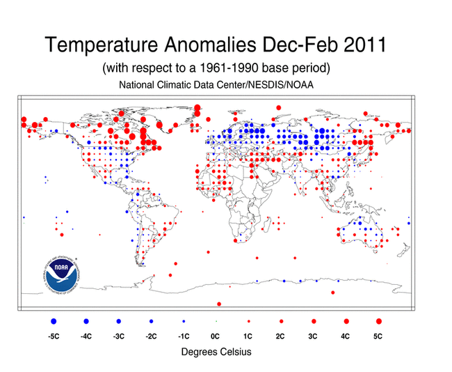
Temperature anomalies for February 2011 and December 2010 – February 2011 are shown on the dot maps below. The dot maps on the left provide a spatial representation of anomalies calculated from the Global Historical Climatology Network (GHCN) dataset of land surface stations using a 1961–1990 base period. The dot maps on the right are a product of a merged land surface and sea surface temperature (SST) anomaly analysis developed by Smith et al. (2008). For the merged land surface and SST analysis, temperature anomalies with respect to the 1971–2000 average for land and ocean are analyzed separately and then merged to form the global analysis. For more information, please visit NCDC's Global Surface Temperature Anomalies page.
February


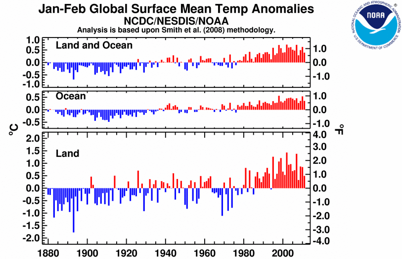
The combined global land and ocean surface temperature for February 2011 tied with 1997 as the 17th warmest February since records began in 1880. The combined global land and ocean temperature anomaly was 0.40°C (0.72°F) above the 20th century average. Sea surface temperatures (SST) during February 2011 were warmer than average across much of the world's oceans. La Niña weakened during February 2011, although SSTs remained below normal across the central and eastern equatorial Pacific Ocean. According to NOAA's Climate Prediction Center (CPC), La Niña will continue to have global impacts but ENSO-neutral conditions are expected by June 2011. The February 2011 worldwide ocean SST tied with 1995 and 1998 as the 10th warmest on record, 0.36°C (0.65°F) above the 20th century average of 15.9°C (60.6°F).
The worldwide land surface temperature tied with 2005 as the 28th warmest February on record, at 0.51°C (0.92°F) above the 20th century average. During February 2011, warmer-than-average temperatures were present across large portions of the world's land areas, with the warmest anomalies covering most of Asia, central Africa, northern Alaska, and southern Greenland. Cooler-than-average regions included Eastern Europe, western Russia, and eastern Siberia.
February 2011 for the Northern Hemisphere combined land and ocean was the 20th warmest February on record. Separately, the Northern Hemisphere land ranked as the 30th warmest February, while the Northern Hemisphere ocean tied with 1997, 2001, and 2009 as the 9th warmest on record.
The February 2011 average temperature for the Southern Hemisphere as a whole (land and ocean surface combined) was 0.38°C (0.68°F) above the 20th century average—the 14th warmest February on record. The Southern Hemisphere land-only temperature during February 2011 tied with five other years as the 25th warmest February on record. The February 2011 Southern Hemisphere ocean temperature was the 12th warmest February on record.
In Australia, the average monthly maximum temperature was much cooler than normal. According to the Australian Bureau of Meteorology (BoM), Australia experienced its fifth coolest February maximum temperatures in the 62-year period of record, at 1.36°C below average. Western Australia had its third coolest February maximum temperatures, at 2.22°C below average, and the Northern Territory was 2.27°C below normal, the seventh coolest maximum temperatures on record and coolest since 1993. The summer (December–February) was the country's coolest since 2001. The cooler temperatures can be attributed in part to an ongoing La Niña event that brought heavy rainfall to much of Australia.
Season (December–February)

The combined global land and ocean surface temperature during December 2010 – February 2011 ranked as the 16th warmest boreal winter (austral summer) on record. During the three-month season, warmer-than-average conditions were particularly felt across western Alaska, eastern Canada, southern Greenland, and northern Siberia. Cooler-than-average regions included Eastern Europe, western Russia, and Mongolia. The seasonal temperature for the worldwide land surface ranked as the 26th warmest December–February on record, at 0.45°C (0.81°F) above the 20th century average. The worldwide ocean surface temperature tied with 1997–1998 as the 10th warmest December–February temperature on record.
The Northern Hemisphere combined land and ocean surface temperature during December 2010 – February 2011 tied with 1957–1958 as the 15th warmest on record. Separately, the Northern Hemisphere land temperature was the 28th warmest December–February on record, while the Northern Hemisphere ocean temperature was the 8th warmest on record.
The Southern Hemisphere combined land and ocean temperature during the three-month period was also the 15th warmest December–February on record, tying with 1994–1995. The Southern Hemisphere land temperature was the 18th warmest December–February on record, while the Southern Hemisphere ocean temperature was the 15th warmest December–February period on record.
Year-to-date (January–February)
The  January–February 2011 map of temperature anomalies shows the presence of warmer-than-average conditions across most of the globe's surface area; however, notably cooler-than-average conditions were present across most of the United States, Europe, western Russia, southern China, much of Australia, the eastern and central Pacific Ocean, and the southern oceans. The combined global land and ocean surface temperature for the year-to-date period tied with 2000 as the 16th warmest January–February period on record. This value is 0.39°C (0.70°F) above the 20th century average.
The average position of the upper-level ridges of high pressure and troughs of low pressure (depicted by positive and negative 500-millibar height anomalies on the 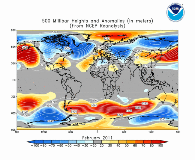 February 2011 map and
  December 2010 – February 2011, respectively) are generally reflected by areas of positive and negative temperature anomalies at the surface, respectively. For other Global products, please see the Climate Monitoring Global Products page.
Images of sea surface temperature conditions are available for all weeks during 2011 from the weekly SST page.
Temperature Rankings and Graphics
Current Month | Seasonal | Year-to-date
| February | Anomaly | Rank (out of 132 years) | Warmest on Record | ||||
|---|---|---|---|---|---|---|---|
| °C | °F | Year | °C | °F | |||
| Global | |||||||
| Land | +0.51 ± 0.31 | +0.92 ± 0.56 | 28th warmest* | 2002 | +1.60 | +2.88 | |
| Ocean | +0.36 ± 0.07 | +0.65 ± 0.13 | 10th warmest* | 1998 | +0.56 | +1.01 | |
| Land and Ocean | +0.40 ± 0.10 | +0.72 ± 0.18 | 17th warmest* | 1998 | +0.83 | +1.49 | |
| Northern Hemisphere | |||||||
| Land | +0.61 ± 0.33 | +1.10 ± 0.59 | 30th warmest | 2002 | +2.12 | +3.82 | |
| Ocean | +0.31 ± 0.08 | +0.56 ± 0.14 | 9th warmest* | 1998 | +0.55 | +0.99 | |
| Land and Ocean | +0.42 ± 0.17 | +0.76 ± 0.31 | 20th warmest | 2002 | +1.06 | +1.91 | |
| Southern Hemisphere | |||||||
| Land | +0.24 ± 0.06 | +0.43 ± 0.11 | 25th warmest* | 2010 | +1.04 | +1.87 | |
| Ocean | +0.41 ± 0.06 | +0.74 ± 0.11 | 12th warmest | 1998 | +0.58 | +1.04 | |
| Land and Ocean | +0.38 ± 0.06 | +0.68 ± 0.11 | 14th warmest* | 2010 | +0.64 | +1.15 | |
*Signifies a tie
* Global Land tied with 2005 as 28th warmest on record.
* Global Ocean tied with 1995 and 1998 as 10th warmest on record.
* Global Land and Ocean tied with 1997 as 17th warmest on record.
* Northern Hemisphere Ocean tied with 1997, 2001, and 2009 as 9th warmest on record.
* Southern Hemisphere Land tied with 1942, 1988, 1995, 1997, and 2002 as 25th warmest on record.
* Southern Hemisphere Land and Ocean tied with 1992 as 14th warmest on record.


| December–February | Anomaly | Rank (out of 132 years) | Warmest on Record | ||||
|---|---|---|---|---|---|---|---|
| °C | °F | Year | °C | °F | |||
| Global | |||||||
| Land | +0.45 ± 0.18 | +0.81 ± 0.32 | 26th warmest | 2007 | +1.36 | +2.45 | |
| Ocean | +0.36 ± 0.07 | +0.65 ± 0.13 | 10th warmest* | 1998 | +0.57 | +1.03 | |
| Land and Ocean | +0.39 ± 0.09 | +0.70 ± 0.16 | 16th warmest | 2007 | +0.71 | +1.28 | |
| Northern Hemisphere | |||||||
| Land | +0.49 ± 0.22 | +0.88 ± 0.40 | 28th warmest | 2007 | +1.61 | +2.90 | |
| Ocean | +0.35 ± 0.08 | +0.63 ± 0.14 | 8th warmest | 1998 | +0.55 | +0.99 | |
| Land and Ocean | +0.40 ± 0.13 | +0.72 ± 0.23 | 15th warmest* | 2007 | +0.92 | +1.66 | |
| Southern Hemisphere | |||||||
| Land | +0.35 ± 0.07 | +0.63 ± 0.13 | 18th warmest | 2010 | +0.83 | +1.49 | |
| Ocean | +0.38 ± 0.07 | +0.68 ± 0.13 | 15th warmest | 1998 | +0.60 | +1.08 | |
| Land and Ocean | +0.38 ± 0.07 | +0.68 ± 0.13 | 15th warmest* | 1998 | +0.62 | +1.12 | |
*Signifies a tie
* Global Ocean tied with 1997–1988 as 10th warmest on record.
* Northern Hemisphere Land and Ocean tied with 1957–1958 as 15th warmest on record.
* Southern Hemisphere Land and Ocean tied with 1994–1995 as 15th warmest on record.


| January–February | Anomaly | Rank (out of 132 years) | Warmest on Record | ||||
|---|---|---|---|---|---|---|---|
| °C | °F | Year | °C | °F | |||
| Global | |||||||
| Land | +0.48 ± 0.22 | +0.86 ± 0.40 | 25th warmest* | 2002 | +1.43 | +2.57 | |
| Ocean | +0.36 ± 0.07 | +0.65 ± 0.13 | 10th warmest* | 1998 | +0.56 | +1.01 | |
| Land and Ocean | +0.39 ± 0.09 | +0.70 ± 0.16 | 16th warmest* | 2002 | +0.72 | +1.30 | |
| Northern Hemisphere | |||||||
| Land | +0.52 ± 0.27 | +0.94 ± 0.49 | 29th warmest | 2002 | +1.89 | +3.40 | |
| Ocean | +0.33 ± 0.08 | +0.59 ± 0.14 | 8th warmest* | 1998 | +0.55 | +0.99 | |
| Land and Ocean | +0.40 ± 0.15 | +0.72 ± 0.27 | 17th warmest* | 2002 | +0.96 | +1.73 | |
| Southern Hemisphere | |||||||
| Land | +0.37 ± 0.07 | +0.67 ± 0.13 | 17th warmest* | 2010 | +0.93 | +1.67 | |
| Ocean | +0.39 ± 0.06 | +0.70 ± 0.11 | 13th warmest* | 1998 | +0.58 | +1.04 | |
| Land and Ocean | +0.38 ± 0.06 | +0.68 ± 0.11 | 15th warmest | 2010 | +0.62 | +1.12 | |
*Signifies a tie
* Global Land tied with 1963 as 25th warmest on record.
* Global Ocean tied with 2001 and 2009 as 10th warmest on record.
* Global Land and Ocean tied with 2000 as 16th warmest on record.
* Northern Hemisphere Ocean tied with 1995 as 8th warmest on record.
* Northern Hemisphere Land and Ocean tied with 1944 as 17th warmest on record.
* Southern Hemisphere Land tied with 1987 as 17th warmest on record.
* Southern Hemisphere Ocean tied with 1999 as 13th warmest on record.

The most current data may be accessed via the Global Surface Temperature Anomalies page.
Precipitation
The maps below represent anomaly values based on the GHCN dataset of land surface stations using a base period of 1961–1990. During February 2011, above-average precipitation fell over areas that included much of Australia (particularly the north), Mauritius, and parts of South America. The areas with the driest anomalies during February 2011 were observed across several islands in the central Pacific Ocean, parts of Brazil, and eastern Australia.
During the seasonal period December 2010 – February 2011, above-average precipitation fell over areas that included most of Australia, Borneo, Samoa, and parts of coastal Brazil. The driest anomalies during December 2010 – February 2011 were observed across in parts of the southeastern United States, French Polynesia, southern Pakistan, Canada's northern Pacific coast, and islands in the central Pacific Ocean.


According to the Australian Bureau of Meteorology (BoM), nationally averaged precipitation during February was the second highest in the 112-year period of record, at 76 percent above normal. South Australia recieved its highest monthly February rainfall on record (414 percent above average), while Western Australia received its second highest (130 percent above average). Several tropical and ex-tropical storms contributed to the wet weather in the north, while remnants of the storms interacted with several cold fronts in the south to produce heavy rains. Seasonally, Australia had its second wettest summer (Northern Hemisphere winter) on record, at 70 percent above average, with all states reporting above-average rainfall. Victoria received its highest summer rainfall on record, while Western Australia and South Australia experienced their second and third wettest summers. The wet conditions led to major flooding in parts of Queensland, New South Wales, Victoria, and Tasmania. La Niña contributed to the anomalous wet weather, along with several tropical cyclones. The above-average cyclone season in this region is typical during a La Niña event.
Additional details on flooding and drought events around the world can also be found on the February 2011 Global Hazards page.
References
Peterson, T.C. and R.S. Vose, 1997: An Overview of the Global Historical Climatology Network Database. Bull. Amer. Meteorol. Soc., 78, 2837-2849.
Quayle, R.G., T.C. Peterson, A.N. Basist, and C. S. Godfrey, 1999: An operational near-real-time global temperature index. Geophys. Res. Lett., 26, 333-335.
Smith, T.M., and R.W. Reynolds (2005), A global merged land air and sea surface temperature reconstruction based on historical observations (1880-1997), J. Clim., 18, 2021-2036.
Smith, et al (2008), Improvements to NOAA's Historical Merged Land-Ocean Surface Temperature Analysis (1880-2006), J. Climate., 21, 2283-2293.