Contents of this Section:
Global Highlights
- The combined global land and ocean average surface temperature for April 2010 was the warmest on record at 14.5°C (58.1°F), which is 0.76°C (1.37°F) above the 20th century average of 13.7°C (56.7°F). This was also the 34th consecutive April with global land and ocean temperatures above the 20th century average.
- The worldwide ocean surface temperature was 0.57°C (1.03°F) above the 20th century average of 16.0°C (60.9°F) and the warmest April on record. The warmth was most pronounced in the equatorial portions of the major oceans, especially the Atlantic.
- The April worldwide land surface temperature was 1.29°C (2.32°F) above the 20th century average of 8.1°C (46.5 °F)—the third warmest on record.
- For the year-to-date, the global combined land and ocean surface temperature of 13.3°C (56.0°F) was the warmest January-April period. This value is 0.69°C (1.24°F) above the 20th century average.
Please Note: The data presented in this report are preliminary. Ranks and anomalies may change as more complete data are received and processed. Effective with the July 2009 State of the Climate Report, NCDC transitioned to the new version (version 3b) of the extended reconstructed sea surface temperature (ERSST) dataset. ERSST.v3b is an improved extended SST reconstruction over version 2. For more information about the differences between ERSST.v3b and ERSST.v2 and to access the most current data, please visit NCDC's Global Surface Temperature Anomalies page.
Introduction
Temperature anomalies for April 2010 are shown on the dot maps below. The dot map on the left provides a spatial representation of anomalies calculated from the Global Historical Climatology Network (GHCN) dataset of land surface stations using a 1961–1990 base period. The dot map on the right is a product of a merged land surface and sea surface temperature (SST) anomaly analysis developed by Smith et al. (2008). For the merged land surface and SST analysis, temperature anomalies with respect to the 1971–2000 average for land and ocean are analyzed separately and then merged to form the global analysis. For more information, please visit NCDC's Global Surface Temperature Anomalies page.

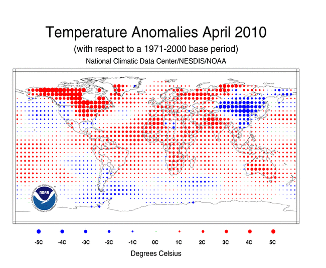
April 2010
April 2010 was characterized by very warm conditions across much of the world. Warmer-than-average conditions during April 2010 were present across much of the world's land areas. The warmest anomalies occurred in southern Asia, northern Africa, the north central and northeastern U.S., Canada, Europe, and parts of northern Russia. Although much of the world's land area was engulfed by warmer-than-average temperatures, cooler-than-average conditions prevailed across Argentina, Mongolia, eastern and southern Russia, and most of China. The worldwide land temperatures for April 2010 ranked as the third warmest—behind 2007 (warmest) and 2000 (second warmest)—on record, 1.29°C (2.32°F) above the 20th century average. Sea surface temperatures (SST) during April 2010 were the warmest on record, with an anomaly of 0.57°C (1.03°F) above the 20th century average. Warmer-than-average conditions enveloped much of the world's oceans, with cooler-than-average conditions across the higher-latitude southern oceans and parts of the northern Pacific Ocean. Although temperatures across the equatorial Pacific Ocean remained above 0.5°C (0.9°F), El Niño weakened during April 2010 as temperature anomalies cooled across the region. According to NOAA's Climate Prediction Center (CPC), a transition to El Niño Southern Oscillation (ENSO) neutral conditions is expected by June 2010 and to continue into the Northern Hemisphere summer 2010. Overall, the combined global land and ocean surface temperature anomaly for April 2010 was the warmest April on record since records began in 1880. The previous record was set in 1998. The combined global land and ocean temperature anomaly was 0.76°C (1.37°F) above the 20th century average.
Did You Know?
CLIMAT Messages
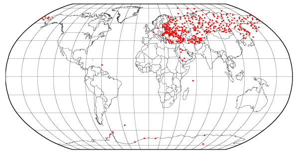
NOAA's National Centers for Environmental Information (NCEI) is the world's largest active archive of weather data. It houses data archives dating back to 1850 from all over the world. Each month, countries from all over the world send their land-based meteorological surface observations, meaning temperature and precipitation measurements, to NCEI to be added to the global record. This information is sent through the World Meteorological Organization's (WMO) Global Telecommunication System (GTS)—a coordinated system for the rapid collection, exchange and distribution of observation data from more than 200 countries around the world. The data are sent in a format called "CLIMAT messages", which are a summary of monthly weather data for a specific station. The CLIMAT message contains information of average pressure at station level, average air temperature, maximum air temperature, minimum air temperature, average vapor pressure, total precipitation, and total sunshine for a particular month. These messages are typically sent to NCEI by the 8th of every month. NCEI uses the data to produce numerous climate publications, such as the Monthly Global Report. The red dots on the loop above show how a typical month's worth of data arrives at NCEI, in a day-by-day, country-by-country fashion. Please refer to the WMO for detailed information about CLIMAT messages or the GTS.
The April 2010 average temperature for the Northern Hemisphere as a whole (land and ocean surface combined) was 0.89°C (1.60°F) above the 20th century average—the warmest April on record. The previous record was set in 2007. The Northern Hemisphere ocean temperature during April 2010 ranked as the warmest on record, with an anomaly of 0.56°C (1.01°F) above the 20th century average—the previous record was set in 2005. However, the Northern Hemisphere land was the third warmest on record, behind 2000 (warmest) and 2007 (second warmest). This value was 1.42°C (2.56°F) above the 20th century average.
According to the German Meteorological Service (Deutscher Wetterdienst), the mean temperature for Germany as a whole was 8.7°C (47.7°F), which is 1.3°C (2.3°F) above the 1961–1990 base period. April 2010 was the 27th warmest April since 1901.
The April 2010 average temperature across China was 9.1°C (48.4°F), which is 1.2°C (2.2°F) below the 1971–2000 average—resulting in the coolest April since 1961, according to the Beijing Climate Center (BCC). The provinces of Liaoning, Jilin, and Shandong had their coolest April on record, while Hebei, Anhui, and Jiangsu experienced their second coolest April since records began in 1951.
According to the India Meteorological Department (IMD), warm conditions were present in Delhi, India during April 2010. It was reported that Delhi had its warmest maximum temperature during the month when temperatures soared to 43.7°C (110.7°F) on 18 April 2010. This was the highest maximum temperature since April 1958 [43.7°C (110.7°F)]. The all-time record for the city is 45.6°C (114.1°F) set on 29 April 1941.
The average temperature for the Southern Hemisphere as a whole (land and ocean surface combined) was 0.64°C (1.15°F) above the 20th century average—the second warmest April on record, behind 1998. The Southern Hemisphere ocean temperature during April 2010 also represented the second warmest on record, with an anomaly of 0.60°C (1.08°F) above the 20th century average. The April 2010 Southern Hemisphere land temperature was 0.94°C (1.69°F) above the 20th century average—the fourth warmest April on record.
According to Australia's Bureau of Meteorology (BoM), April 2010 was warmer than normal over most of the country. For Australia as a whole, minimum temperatures were 1.68°C (3.02°F) above average, resulting in the second highest minimum temperatures, behind 2005. Regionally, Western Australia had its second highest minimum temperatures, while South Australia, Tasmania, and Victoria had their third highest on record. Meanwhile, maximum temperatures were 0.93°C (1.67°F) above normal for the continent—the tenth highest maximum temperature on record. It was reported that Western Australia had its fifth highest maximum temperature on record.
Australia's BoM also reported that Victoria and Tasmania experienced their warmest 12-month period (May 2009–April 2010) since national records began. Separately, all twelve months were warmer than average for both states, with October being the exception for the state of Tasmania. These warm conditions contributed to the anomalously warm temperature during May 2009–April 2010. The mean temperature during May 2009–April 2010 for the state of Victoria was 15.36°C (59.65°F), which is 4.36°C (7.85°F) above average. The previous record of 15.25°C (59.45°F) was set on February 2007–January 2008. Similarly, Tasmania had a mean temperature of 11.43°C (52.57°F) during May 2009-April 2010, which is 2.43°C (4.37°F) above average—exceeding the previous record of 11.34°C (52.41°F) set on May 1998-April 1999. It was reported that the mean temperature during May 2009–April 2010 for Australia as a whole was 22.69°C (72.84°F), which is 0.88° (1.58°F) above average—resulting in the third warmest 12-month period on record, behind 1997–1998 and 2005–2006.
Of note, Melbourne's (Victoria's capital) daily maximum temperature exceeded 20°C (68°F) for 123 consecutive days (8 December 2009 - 10 April 2010), surpassing the previous record of 78 consecutive days above 20°C (68°F).
Year-to-date (January–April)
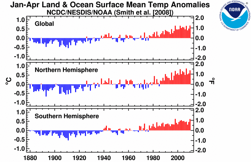
The  January–April 2010 map of temperature anomalies shows that for the first four months of the year anomalous warm temperatures were present over much of the world, with the exception of cooler-than-average conditions across the higher-latitude southern oceans, the northern Pacific Ocean, along the western South American coast, Mongolia, northern China, northern Australia, the south central and southeastern U.S., northern Mexico, and most of Europe and Russia. The combined global land and ocean surface temperature for January–April period was the warmest January-April period on record. This value is 0.69°C (1.24°F) above the 20th century average. Separately, the worldwide land surface temperature ranked as the third warmest on record, behind 2007 (warmest) and 2002 (second warmest), while the worldwide ocean surface temperature ranked as the second warmest January–April on record—behind 1998.
The average position of the upper-level ridges of high pressure and troughs of low pressure (depicted by positive and negative 500-millibar height anomalies on the  April 2010 map, respectively) are generally reflected by areas of positive and negative temperature anomalies at the surface, respectively. For other Global products, please see the Climate Monitoring Global Products page.
Images of sea surface temperature conditions are available for all weeks during 2009 from the weekly SST page.
Temperature Rankings and Graphics
| April | Anomaly | Rank (out of 131 years) | (Next) Warmest on Record | ||||
|---|---|---|---|---|---|---|---|
| °C | °F | Year | °C | °F | |||
| Global | |||||||
| Land | +1.29 | +2.32 | 3rd warmest | 2007 | +1.42 | +2.56 | |
| Ocean | +0.57 | +1.03 | Warmest | (1998) | +0.56 | +1.01 | |
| Land and Ocean | +0.76 | +1.37 | Warmest | (1998) | +0.71 | +1.28 | |
| Northern Hemisphere | |||||||
| Land | +1.42 | +2.56 | 3rd warmest | 2000 | +1.67 | +3.01 | |
| Ocean | +0.56 | +1.01 | Warmest | (2005) | +0.51 | +0.92 | |
| Land and Ocean | +0.89 | +1.60 | Warmest | (2007) | +0.85 | +1.53 | |
| Southern Hemisphere | |||||||
| Land | +0.94 | +1.69 | 4th warmest | 2005 | +1.05 | +1.89 | |
| Ocean | +0.60 | +1.08 | 2nd warmest | 1998 | +0.62 | +1.12 | |
| Land and Ocean | +0.64 | +1.15 | 2nd warmest | 1998 | +0.65 | +1.17 | |
*Signifies a tie


| January–April | Anomaly | Rank (out of 131 years) | (Next) Warmest on Record | ||||
|---|---|---|---|---|---|---|---|
| °C | °F | Year | °C | °F | |||
| Global | |||||||
| Land | +1.07 | +1.93 | 3rd warmest | 2007 | +1.32 | +2.38 | |
| Ocean | +0.55 | +0.99 | 2nd warmest | 1998 | +0.56 | +1.01 | |
| Land and Ocean | +0.69 | +1.24 | Warmest | (2002)* | +0.68 | +1.22 | |
| Northern Hemisphere | |||||||
| Land | +1.13 | +2.03 | 5th warmest | 2007 | +1.53 | +2.75 | |
| Ocean | +0.53 | +0.95 | Warmest | (1998) | +0.52 | +0.94 | |
| Land and Ocean | +0.76 | +1.37 | 3rd warmest | 2007 | +0.86 | +1.55 | |
| Southern Hemisphere | |||||||
| Land | +0.92 | +1.66 | Warmest | (2005) | +0.87 | +1.57 | |
| Ocean | +0.58 | +1.04 | 2nd warmest | 1998 | +0.60 | +1.08 | |
| Land and Ocean | +0.62 | +1.12 | 2nd warmest | 1998 | +0.63 | +1.13 | |
*Signifies a tie

The most current data may be accessed via the Global Surface Temperature Anomalies page.
Precipitation
The maps below represent anomaly values based on the GHCN dataset of land surface stations using a base period of 1961-1990. Precipitation anomalies on a month-to-month basis are often highly variable across the globe and even within regions. The areas with the wettest anomalies during April 2010 included eastern Brazil, northern South America, and parts of eastern Asia. The driest anomalies were present across the Hawaiian Islands, the southern Pacific Islands, southern South America, and parts of central Europe.


According to Beijing Climate Center (BCC), the monthly averaged precipitation in China was 56.1 mm (2.2 inches) during April 2010, which is 12.3 mm (0.5 inch) above the 1971–2000 average—resulting in the wettest April since 1974. On a provincial level, Tibet had its wettest April since national records began in 1951. It was reported that beneficial rains since March 2010 alleviated drought in Southwest China. Heavy rain fell during April 10th–14th and April 19th–22nd, triggering deadly floods that caused 15 fatalities (Source: BCC).
Australia as a whole experienced above average rainfall during April 2010 (34 percent above average), the 17th wettest April on record. Averaged nationally during the wet season (October–April), October 2009–April 2010 ranked as the 16th wettest such period since national records began in 1900. Regionally, the Northern Territory had its fifth-wettest October–April (34 percent above average) and New South Wales had its seventh-wettest period on record (15 percent above average).
According to the German Meteorological Service (Deutscher Wetterdienst), the monthly averaged precipitation in Germany was 20.7 mm (0.8 inch)—which is 37.5 mm (1.5 inches) below average. This value ranks as the second driest April since 1901, behind 2007.
According to Mexico's National Water Commission (CONAGUA), Mexico, as a whole, had its third wettest April in 69 years.
In New Zealand, soil moisture deficits continued to affect many areas of the North Island. According to New Zealand's National Institute of Water and Atmospheric Research (NIWA), April 2010 was a very dry month for much of the North Island and northern South Island. Although much needed precipitation fell over drought-stricken areas, it wasn't enough to alleviate drought. In April 2010, drought was declared in Auckland, Waikato, Bay of Plenty, South Taranaki, South Canterbury, and Otago. In contrast, Fiordland, south Westland, and parts of Southland were extremely wet during April 2010 as more than double the average precipitation fell in the region.
Additional details on flooding and drought can also be found on the April 2010 Global Hazards page.
References
Peterson, T.C. and R.S. Vose, 1997: An Overview of the Global Historical Climatology Network Database. Bull. Amer. Meteorol. Soc., 78, 2837-2849.
Quayle, R.G., T.C. Peterson, A.N. Basist, and C. S. Godfrey, 1999: An operational near-real-time global temperature index. Geophys. Res. Lett., 26, 333-335.
Smith, T.M., and R.W. Reynolds (2005), A global merged land air and sea surface temperature reconstruction based on historical observations (1880-1997), J. Clim., 18, 2021-2036.
Smith, et al (2008), Improvements to NOAA's Historical Merged Land-Ocean Surface Temperature Analysis (1880-2006), J. Climate., 21, 2283-2293.