
Global Summary:
PLEASE NOTE: The ranks and temperature anomalies in this report represent the values known at the time the report was issued. The actual ranks will change as subsequent years are added to the dataset. The anomalies themselves may change slightly as missing or erroneous data is resolved. Also, in 2009, NCDC switched to ERSST version 3b (from version 2) as a component of its global surface temperature dataset. Because the versions have slightly different methodologies, the calculated temperature anomalies will differ slightly. For more information about this switch please see the Global Surface Temperature Anomalies FAQ .
Global Temperatures
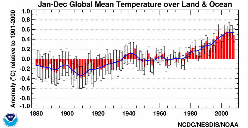
The global January-December temperature for combined land and ocean surfaces was 0.49°C (0.88°F) above the 20th century average, tying with 2001 as the eighth warmest since records began in 1880. Globally averaged land temperatures were 0.81°C (1.46°F) above average, while the ocean temperatures were 0.37°C (0.67°F) above average, ranking as the sixth warmest and tenth warmest, respectively. Eight of the ten warmest years on record have occurred since 2001, part of a rise in temperatures of 0.5°C (0.9°F) since 1880. See the global time series.
| Global Top 10 Warm Years (Jan-Dec) | Anomaly °C | Anomaly °F |
|---|---|---|
| 2005 | 0.61 | 1.10 |
| 1998 | 0.58 | 1.04 |
| 2002 | 0.56 | 1.01 |
| 2003 | 0.56 | 1.01 |
| 2006 | 0.55 | 0.99 |
| 2007 | 0.55 | 0.99 |
| 2004 | 0.53 | 0.95 |
| 2001 | 0.49 | 0.88 |
| 2008 | 0.49 | 0.88 |
| 1997 | 0.46 | 0.83 |
The year began with a cold phase (La Niña) El Niño-Southern Oscillation (ENSO) which developed during late 2007, transitioned to a neutral phase in June 2008, and remained neutral through the end of the year. The presence of a strong La Niña dampened ocean sea surface temperatures (SSTs) and contributed to a February global average temperature that was the coolest since the La Niña episode of 2000-2001. During March, sea surface temperature (SST) anomalies were cooler-than-average in all Niño regions, with the exception of the Niño 1+2 region where the monthly temperature anomaly rose to +0.82°C (+1.48°F). Temperatures across Niño 3.4 and Niño 4 regions increased slightly but the anomalies remained below average. These conditions indicated the first signs of weakening of the cold event (La Niña), however a moderate La Niña remained across the equatorial Pacific Ocean. By June, temperatures across the Niño 3.4 and Niño 4 regions continued to warm and the Oceanic Niño Index threshold [3-month (April-June) running mean] was -0.50°C (-0.90°F), indicating a transition into a neutral phase. By the end of December, neutral phase ENSO conditions persisted across the equatorial Pacific Ocean, although characteristics of a developing La Niña were present. According to the latest information from NOAA's Climate Prediction Center, La Niña conditions could develop into early 2009. For more information on the state of ENSO during 2008, please see the ENSO monitoring annual summary.
| January- December |
Anomaly | Rank | Warmest Year on Record |
|---|---|---|---|
GlobalLandOcean Land and Ocean |
+0.81°C (+1.46°F) +0.37°C (+0.67°F) +0.49°C (+0.88°F) |
6thwarmest 10th warmest 8th warmest |
2007 (+1.02°C/1.84°F) 2003 (+0.48°C/0.86°F) 2005 (+0.61°C/1.10°F) |
Northern HemisphereLandOcean Land and Ocean |
+0.89°C (+1.60°F) +0.40°C (+0.72°F) +0.59°C (+1.06°F) |
5th warmest 9th warmest 8th warmest |
2007 (+1.18°C/2.12°F) 2005 (+0.54°C/0.97°F) 2005 (+0.72°C/1.30°F) |
Southern HemisphereLandOcean Land and Ocean |
+0.54°C (+0.97°F) +0.35°C (+0.63°F) +0.38°C (+0.68°F) |
6th warmest 10th warmest 9th warmest |
2005 (+0.81°C/1.46°F) 1998 (+0.50°C/0.90°F) 1998 (+0.53°C/0.95°F) |
The 1901-2000 average combined land and ocean annual temperature is 13.9°C (56.9°F), the annually averaged land temperature for the same period is 8.5°C (47.3°F), and the long-term annually averaged sea surface temperature is 16.1°C (60.9°F).
Regional Temperatures
Warmer-than-average temperatures occurred throughout the year in most land areas of the world, with the exception of cooler-than-average conditions across Colombia, parts of Alaska, central Canada, and the midwestern continental U.S. The warmest above-average temperatures occurred throughout high latitude regions of the Northern Hemisphere including much of Europe and Asia. Temperature anomalies in these regions ranged from 2-4°C (3.6-7.2°F) above the 1961-1990 average.


The map, above left, is created using data from the Global Historical Climatology Network (GHCN), a network of more than 7,000 land surface observing stations. The map, above right, is a product of a merged land surface and sea surface temperature anomaly analysis developed by Smith and Reynolds (2005). Temperature anomalies with respect to the 1961-1990 mean for land and ocean are analyzed separately and then merged to form the global analysis. Additional information on this product is available.
Notable temperature extremes in 2008 include the below average temperatures across the Middle East, central Asia, and southeast China during January 2008. Parts of Turkey experienced their coldest January nights in 50 years (WMO). Freezing temperatures and heavy snowfall affected over 78 million people and resulted in 60 fatalities across China. The anomalously cool conditions over central Asia and southeast China were associated with the largest January snow cover extent on record for the Eurasian continent and for the Northern Hemisphere. In contrast, above average temperatures during January were observed across Australia, Europe, and northern Asia. Temperatures in Australia were 3-5°C (5-7°F) above average across large areas in Western and Central Australia. For the nation as a whole, the January 2008 average temperature was 1.23°C (2.21°F) above the 1961-1990 mean, making it the warmest January on record [Australia's Bureau of Meteorology(BoM)]. Most parts of the Fenno-Scandinavia region had their warmest winter since records began (WMO).
In March, South Australia experienced a record heat wave which brought scorching temperatures across the state. Adelaide, South Australia's capital, experienced its longest running heat wave on record, with 15 consecutive days of maximum temperatures above 35°C (95°F). This shattered the previous record of 8 consecutive days which was tied on numerous occasions, most recently in February 2004. Also, Adelaide set a new record as having the longest number of consecutive days exceeding 35°C (95°F) for all Australian state capital cities. The second longest such streak was 10 days, set in February 1988 in the city of Perth. Overall, South Australia had its third warmest March since records began with 2.35°C (4.23°F) above the 1961-1990 average (BoM).
During the second and third weeks of September, Hungary saw a marked contrast in temperatures. The city of Szeged set a new maximum temperature record for September 7 when temperatures rose to 37.6°C (100°F), surpassing the 1946 record of 36.7°C (98°F). Meanwhile, on September 15, a new national record was set when the city of Sopron, Hungary recorded its coldest temperature of 8.6°C (47°F), surpassing the previous record set in Zalaegerszeg in 1925 when temperatures fell to 10.5°C (51°F).
Additional information on other notable weather events can be found in the Significant Events section of this report.
Global Precipitation

Global precipitation in 2008 was above the 1961-1990 average. Precipitation throughout the year was variable in many areas. Regionally, drier than average conditions were widespread across the Hawaiian Islands, the western and south-central contiguous U.S., southwestern Alaska, southeastern Africa, southern Europe, northern India, and parts of Argentina, Uruguay, eastern Asia, the eastern coast of Brazil, and southern Australia. Most of Europe, western Africa, the northeastern and central contiguous U.S., parts of northern South America and southeastern Asia experienced wetter than average conditions.

The Philippine Islands received much-above-average precipitation in 2008 due to several tropical cyclones that made landfall in the region during the active season, dumping heavy precipitation which led to widespread floods and landslides on the islands. In southern China, severe storms and Typhoon Fengshen brought heavy rain across the area, causing widespread floods and landslides. The copious rainfall across southern China made June 2008 the wettest month on record for Hong Kong, Guangzhou, and Macao, according to the Hong Kong Observatory. Records began in 1884.
Precipitation across Australia was 73 percent below normal during May, resulting in the driest May on record. May 2008 had a national average of 7.86 mm (0.31 inches) of rain, supplanting the 1961 record of 8.27 mm (0.32 inches). During March-May, Australia, as a whole, experienced 53 percent below-normal precipitation, resulting in the eighth driest austral autumn (March-May). Parts of Australia have been experiencing drought conditions for over a decade.
In the U.S., heavy rain fell across much of the Midwest during the first half of June, causing the worst floods in 15 years and setting numerous new record river crest levels. For more information, please visit the June Midwest Flooding page.
Unsettled weather affected the British Isles during the boreal summer (June-August), resulting in a summer rainfall total that was much above the 1971-2000 mean. June-August 2008 period ranked as one of the top 10 wettest summers since records began there in 1914. Northern Ireland experienced its second wettest boreal summer when a total of 393.7 mm (15.5 inches) of rain fell. The wettest boreal summer for Northern Ireland was set in 1958 when 404.0 mm (15.9 inches) of rain fell.
Prolonged drought (January-September) across parts of Argentina, Paraguay, and Uruguay significantly affected agriculture. Some areas experienced their worst drought in over five decades.
During September 2008, Hurricanes Gustav, Hanna, and Ike, and Tropical Storm Kyle brought torrential rain across the Caribbean and parts of the continental U.S., triggering fatal floods and wreaking havoc across the affected areas.
For more information about precipitation extremes during 2008, see the annual report of Significant Events.
Additional information on other notable weather events can be found in the Significant Events section of this report.
NOAA's National Climatic Data Center is the world's largest active archive of weather data. The temperature and precipitation rankings are available from the center by calling: 828-271-4800.
NOAA works closely with the academic and science communities on climate-related research projects to increase the understanding of El Niño and improve forecasting techniques. NOAA's Climate Prediction Center monitors, analyzes and predicts climate events ranging from weeks to seasons for the nation. NOAA also operates the network of data buoys and satellites that provide vital information about the ocean waters, and initiates research projects to improve future climate forecasts.
References
Peterson, T.C. and R.S. Vose, 1997: An Overview of the Global Historical Climatology Network Database. Bull. Amer. Meteorol. Soc., 78, 2837-2849.
Quayle, R.G., T.C. Peterson, A.N. Basist, and C. S. Godfrey, 1999: An operational near-real-time global temperature index. Geophys. Res. Lett., 26, 333-335.
Smith, T.M., and R.W. Reynolds (2005), A global merged land air and sea surface temperature reconstruction based on historical observations (1880-1997), J. Clim., 18, 2021-2036.