Global Highlights:
- Based on preliminary data, the globally averaged combined land and sea surface temperature was the thirteenth warmest on record for April and the January-April year-to-date period ranked twelfth warmest.
- April 2008 temperatures were above average in Europe, Mexico, eastern Brazil, northwestern Alaska, northern Africa, most of Asia, the northeastern and parts of the southwestern states of the contiguous U.S. Cooler-than-average conditions occurred in the central and western U.S., eastern Australia, central Russia, and parts of India and South Africa.
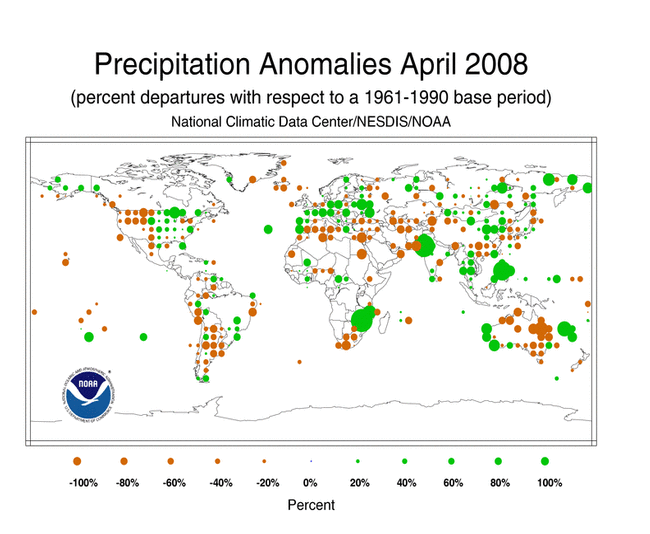
- Precipitation during April 2008 was above average in the Philippines, the central and midwestern contiguous U.S., and parts of Europe, southeastern Asia, and South America. Drier-than-average conditions were observed across the Hawaiian Islands, eastern and northern Australia, and southeastern China, western U.S. and parts of the South America and Africa.
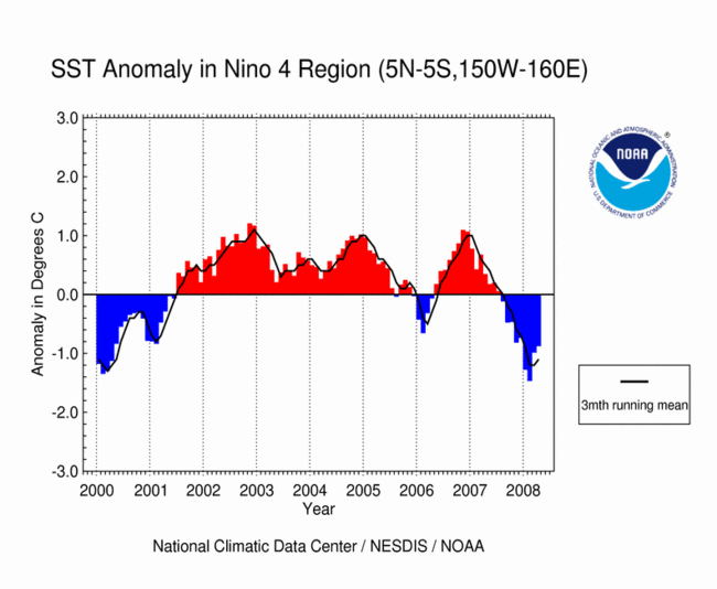
- Cold phase (La Niña) ENSO conditions were present across the equatorial Pacific Ocean during April.
Contents of this Section:
The data presented in this report are preliminary. Ranks and anomalies may change as more complete data are received and processed. The most current data may be accessed via the Global Surface Temperature Anomalies page.
Introduction
Temperature anomalies for April 2008 are shown on the dot maps below. The dot map, below left, provides a spatial representation of anomalies calculated from the Global Historical Climatology Network (GHCN) data set of land surface stations using a 1961-1990 base period. The dot map, below right, is a product of a merged land surface and sea surface temperature anomaly analysis developed by Smith and Reynolds (2005). Temperature anomalies with respect to the 1961-1990 mean for land and ocean are analyzed separately and then merged to form the global analysis. Additional information on this product is available.
The January-April 2008 map shows anomalous warm conditions over much of the world's land surface, especially across Europe and northern Asia where temperatures were 2°-4°C (4°-7°F) above average. Elsewhere, cooler-than-average conditions were observed in parts of the western and north-central states of the contiguous U.S., central Africa, eastern Australia, and parts of Colombia. As for sea surface temperatures (SST), warmer-than-average conditions were present in the Atlantic and Indian oceans, the Niño 1+2 region, and parts of the northwest Pacific Ocean. Cooler-than-average conditions were observed in all of the Niño regions (with the exception of Niño 1+2 region), parts of the northeastern Pacific and some areas in the southern oceans.
During April, above average temperatures were observed across Europe, Mexico, eastern Brazil, northwestern Alaska, northern Africa, most of Asia, the northeastern and parts of the southwestern states of the contiguous U.S. As shown in the April 2008 map, temperatures across Europe and most of Asia were 1°-4°C (2°-7°F) above the 1961-1990 mean. The warm conditions in April over Europe and Asia were associated with the least snow cover extent on record for the Eurasian continent. Meanwhile, cooler-than-average conditions were present across the central and western U.S., eastern Australia, central Russia, and parts of India and South Africa.
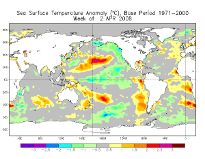
SSTs during April 2008 were warmer than average in the Atlantic, northwestern Pacific, eastern equatorial Pacific, and parts of the south Indian and south Pacific oceans. Cooler-than-average conditions were present in parts of the southern oceans, parts of the North Indian Ocean, and in the Niño regions, with the exception of the Niño 1+2 region where the monthly temperature anomaly cooled slightly to +0.41°C (+0.74°F). Temperatures across the Niño 3.4 and Niño 4 regions warmed but the anomalies remained below average. Please see the latest ENSO discussion for additional information.


The mean position of the upper level ridges of high pressure and troughs of low pressure (depicted by positive and negative 500-millibar height anomalies on the April map) are generally reflected by areas of positive and negative temperature anomalies at the surface, respectively. For other Global products, please see the Climate Monitoring Global Products page.
Images of sea surface temperature conditions are available for all weeks during 2008 at the weekly SST page.
Temperature Rankings and Graphics
Effective with the February 2006 report, NCDC transitioned from the use of the Operational Global Surface Temperature Index (Quayle et al. 1999) to the blended land and ocean dataset developed by Smith and Reynolds (2005). The differences between the two methods are discussed in Smith et al. (2005).
The combined global land and ocean surface temperature was the thirteenth warmest on record in April and the twelfth warmest on record for January-April year-to-date period. La Niña, the cold phase of the El Niño-Southern Oscillation, persisted in the equatorial Pacific, damping ocean surface temperatures. The global average ocean sea surface temperature (SST) in April was the 9th warmest on record.
| April | Anomaly | Rank | Warmest (or Next Warmest) Year on Record |
|---|---|---|---|
GlobalLandOcean Land and Ocean |
+0.64°C (+1.15°F) +0.33°C (+0.59°F) +0.41°C (+0.74°F) |
12th warmest 9th warmest 13th warmest |
2007 (+1.40°C/2.52°F) 1998 (+0.53°C/0.95°F) 1998 (+0.70°C/1.26°F) |
Northern HemisphereLandOcean Land and Ocean |
+0.81°C (+1.46°F) +0.33°C (+0.59°F) +0.51°C (+0.92°F) |
9th warmest 8th warmest 7th warmest |
2000 (+1.66°C/2.99°F) 2004 (+0.53°C/0.95°F) 2007 (+0.84°C/1.51°F) |
Southern HemisphereLandOcean Land and Ocean |
+0.08°C (+0.14°F) +0.33°C (+0.59°F) +0.29°C (+0.52°F) |
49th warmest 19th warmest 22nd warmest |
2005 (+1.09°C/1.96°F) 1998 (+0.59°C/1.06°F) 1998 (+0.63°C/1.13°F) |


| January-April | Anomaly | Rank | Warmest (or Next Warmest) Year on Record |
|---|---|---|---|
GlobalLandOcean Land and Ocean |
+0.77°C (+1.39°F) +0.29°C (+0.52°F) +0.42°C (+0.76°F) |
11th warmest 13th warmest 12th warmest |
2007 (+1.36°C/2.45°F) 1998 (+0.53°C/0.95°F) 2007 (+0.68°C/1.22°F) |
Northern HemisphereLandOcean Land and Ocean |
+0.91°C (+1.64°F) +0.29°C (+0.52°F) +0.52°C (+0.94°F) |
11th warmest 8th warmest 9th warmest |
2002 (+1.56°C/2.81°F) 2004 (+0.50°C/0.90°F) 2007 (+0.87°C/1.57°F) |
Southern HemisphereLandOcean Land and Ocean |
+0.31°C (+0.56°F) +0.30°C (+0.54°F) +0.30°C (+0.54°F) |
20th warmest 23rd warmest 22nd warmest |
2005 (+0.88°C/1.58°F) 1998 (+0.56°C/1.01°F) 1998 (+0.61°C/1.10°F) |


The most current data may be accessed via the Global Surface Temperature Anomalies page.
Precipitation
The maps below represent anomaly values based on the GHCN data set of land surface stations using a base period of 1961-1990. During April 2008, above average precipitation fell over areas that include the Philippines Islands, central and midwestern contiguous U.S., and parts of Europe, southeastern Asia, and South America. Drier-than-average conditions were observed across the Hawaiian Islands, eastern and northern Australia, and southeastern China, western U.S. and parts of the South America and Africa.
In the U.S., rainfall during April led to improving drought conditions in much of the Southeast, but at month's end, moderate to extreme drought remained over 43% of the region. Torrential rains on April 30 affected parts of the northeastern U.S. and southeastern Canada, prompting the overflow of rivers and causing record breaking floods. In Brazil, heavy rainfall caused widespread floods that destroyed crops, killed 15 people, and affected more than 30,000 across the northeast part of the country. In Haiti, heavy rain prompted a deadly mudslide on the 24th that killed three children and injured 2 people. Additional details on flooding and drought can also be found on the April Global Hazards page.
According to the Australian Bureau of Meteorology (BoM), Western Australia's capital, Perth, had the wettest April since records began in 1876, with a total of 152.4 mm (6 inches) of rain as of April 29. The previous record was set in 1926 when a total of 148.8 mm (5.9 inches) of rain fell. Perth also had the second wettest January-April period on record with a total of 214.2 mm (8.4 inches) of rainfall, behind 1955 which had a total of 296.9 mm (11.7 inches) of rain. A complete summary is available courtesy of the Australian BoM.

ENSO SST Analysis
Sea surface temperature (SST) anomalies in the equatorial Pacific Ocean warmed, but remained below average. SST anomalies in the Niño 3.4 region rose to -0.75°C (-1.35°F), a warming of +0.28°C (0.50°F) compared to March's anomaly. These conditions indicate that some weakening of La Niña (ENSO cold phase) occurred during April, but cold phase (La Niña) conditions remained across the tropical Pacific Ocean (shown in the adjacent animation of weekly sea surface temperature anomalies). A comprehensive summary of April 2008 ENSO conditions can be found on the ENSO monitoring page. For the latest advisory on ENSO conditions go to NOAA's Climate Prediction center (CPC) and the CPC ENSO Diagnostic Discussion.
Images of sea surface temperature conditions are available for all weeks since 2003 at the weekly SST page.
References
Peterson, T.C. and R.S. Vose, 1997: An Overview of the Global Historical Climatology Network Database. Bull. Amer. Meteorol. Soc., 78, 2837-2849.
Quayle, R.G., T.C. Peterson, A.N. Basist, and C. S. Godfrey, 1999: An operational near-real-time global temperature index. Geophys. Res. Lett., 26, 333-335.
Smith, T.M., and R.W. Reynolds (2005), A global merged land air and sea surface temperature reconstruction based on historical observations (1880-1997), J. Clim., 18, 2021-2036.