Global Highlights:
- Global average combined land and sea surface temperature was
the third warmest for June 2003
- Temperatures were much above average across most of Europe and
South America with below average temperatures in the northeastern
U.S. and the western half of Russia
- Precipitation during June 2003 was above average in the
southeastern U.S. and East Asia, with drier than average conditions
over most of Europe and India
- Sea-surface temperatures in the central and eastern equatorial
Pacific began to indicate that ENSO was less likely to cycle into
La Nina
|
|
Contents of this Section:
|
The data
presented in this report are preliminary. Ranks and anomalies may
change as more complete data are received and processed. The most
current data may be accessed via the Global Surface
Temperature Anomalies page.
Introduction

larger image |
June temperature
anomalies calculated from the Global Historical Climatology Network
data set of land surface stations (using a 1961-1990 base period)
also show above average temperatures throughout most of Australia,
much of Europe, South America and Alaska. Monthly temperatures were
3-5°C (5.4-9°F) above the mean. Cooler than average
temperatures were present throughout the eastern U.S. into the
Great Plains, and in Kazakhstan, where monthly temperatures were as
much as 2-4°C (3.6-7.2°F) below average. |
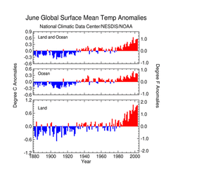
Temperature
June
- For June 2003, the global average land and ocean
surface temperature was 0.54°C (0.97°F) above the 1880-2002
average, ranking as the third warmest June in the period of
record
- The warmest June occurred in 1998, when the
global anomaly was +0.63°C (+1.13°F)
- Globally averaged land temperatures were second
warmest on record, 0.96°C (1.73°F) above the long-term
mean
|
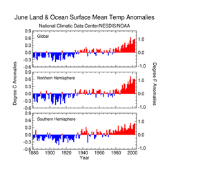
larger image |
- June 2003 temperatures averaged across the
Northern Hemisphere were second warmest on record, 0.61°C
(1.10°F) above the long term mean
- Temperatures averaged throughout the Southern
Hemisphere were second warmest, 0.47°C (0.85°F) above
average
|
larger image |
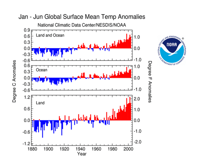
January-June
- For January-June 2003, the global average
land
and ocean surface temperature was 0.55°C (1.00°F) above
the long term mean, third warmest
- Ocean surface temperatures were 0.40°C
(0.72°F) above the 1880-2002 mean, third warmest for
January-June 2003.
- January-June 2003 temperatures averaged across
the Northern Hemisphere were eighth warmest on record, 0.89°C
(1.60°F) above the long term mean
- Temperatures averaged throughout the Southern
Hemisphere were second warmest, 0.72°C (1.30°F) above
average
|

larger image |

larger image |
- Serial monthly global surface temperature
departures with respect to a 1971-2000 mean are shown in the figure
to the left
- Globally averaged surface temperatures (land and
ocean) have been warmer than the 1971-2000 average for the last 86
consecutive months
|
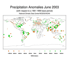
Precipitation
- During June 2003, much above average
precipitation fell across the southeastern U.S., much of Brazil,
parts of East Asia and the eastern coast of Australia
- Below average precipitation was observed in the
majority of Europe, India and western Canada
- Additional regional analysis can be found on the
Global Hazards page
|
 larger image
 |
ENSO SST Analysis

Click here for animated loop |
- Ocean and
climate indicators used to determine the state of ENSO suggest
that the projected transition to La Nina stalled during June 2003.
The negative anomalies of sea-surface temperature diminshed across
the central and equatorial Pacific, as shown in the adjacent
animation of weekly sea surface temperature anomalies. This trend
as well as others, such as deepening of the eastern equatorial
Pacific oceanic thermocline are indications of a cessation of
development to La Nina conditions, although there is considerable
uncertainty for the next several months. ENSO conditions in the
tropical Pacific are near-neutral as of the end of June 2003. The
most up-to-date information on ENSO (El Nino/Southern Oscillation)
conditions can be found at NOAA's Climate
Prediction Center (CPC) and the CPC ENSO Diagnostic
Discussion
- Images of sea surface temperature conditions are
available for all months to date during 2003 at the weekly sst page
|
References:
Peterson, T.C. and R.S. Vose, 1997: An Overview of the Global
Historical Climatology Network Database. Bull. Amer. Meteorol.
Soc., 78, 2837-2849.


 larger image