NH Snow Cover Extent
| December 2020 | Snow Cover Extent | Anomaly 1991-2020 | Trend per decade | Rank (55 years) | Record | ||||||
|---|---|---|---|---|---|---|---|---|---|---|---|
| million km² | million mi² | million km² | million mi² | million km² | million mi² | Year(s) | million km² | million mi² | |||
| Northern Hemisphere | 43.70 | 16.87 | -0.57 | -0.22 | +0.33 | +0.13 | Largest | 32nd | 2012 | 46.85 | 18.09 |
| Smallest | 24th | 1980 | 37.44 | 14.46 | |||||||
| North America | 16.50 | 6.37 | -0.40 | -0.15 | +0.11 | +0.04 | Largest | 36th | 2009 | 18.27 | 7.05 |
| Smallest | 20th | 1980 | 14.56 | 5.62 | |||||||
| Eurasia | 27.20 | 10.50 | -0.16 | -0.06 | +0.22 | +0.08 | Largest | 26th | 2002 | 29.70 | 11.47 |
| Smallest | 30th | 1980 | 22.88 | 8.83 | |||||||
Data Source: Global Snow Laboratory, Rutgers University. Period of record: 1966–2020 (55 years)
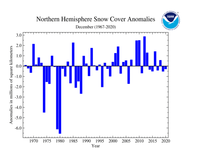
The Northern Hermisphere snow cover extent for December 2020 was near average at 43.70 million square km (16.87 million square miles). This value is 280,000 square km (110,000 square miles) below the 1981–2010 average and the 24th smallest December snow cover extent in the 55-year record.

The North American snow cover extent was 350,000 square km (140,000 square miles) below average, resulting in the 20th smallest December extent on record. Above-average December 2020 was limited to parts of southwestern and southeastern Canada, the northeastern contiguous U.S., and across the southern Rocky Mountains. Meanwhile, below-average snow cover extent was observed across parts of the northern and southwestern contiguous U.S. Canada, and the contiguous U.S. were slightly below average. Alaska snow cover extent for December 2020 tied for the largest December snow cover extent on record.
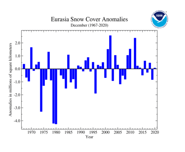
Eurasia's December 2020 snow cover extent was near average at 27.20 million square km (10.50 million square miles). Above-average snow cover extent was observed across parts of southern Khazakstan, southern Mongolia, northern China, and across central Asia. Below-average December snow cover extent was observed across Europe and southern China.
Sea Ice Extent
The sea ice extent data for the Arctic and Antarctic are provided by the National Snow and Ice Data Center (NSIDC) and are measured from passive microwave instruments onboard NOAA Satellites. The sea ice extent period of record is from 1979–2020 for a total of 42 years.
| December 2020 | Sea Ice Extent | Anomaly 1991-2020 | Trend per decade | Rank (42 years) | Record | ||||
|---|---|---|---|---|---|---|---|---|---|
| million km² | million mi² | Year(s) | million km² | million mi² | |||||
| Northern Hemisphere | 11.73 | 4.53 | -5.40% | -3.63% | Largest | 40th | 1982 | 13.64 | 5.27 |
| Smallest | 2nd | 2016 | 11.46 | 4.42 | |||||
| Southern Hemisphere | 10.57 | 4.08 | +1.63% | +0.67% | Largest | 15th | 2007 | 11.98 | 4.63 |
| Smallest | 27th | 2016 | 8.28 | 3.20 | |||||
| Globe | 22.30 | 8.61 | -2.24% | -1.71% | Largest | 35th | 1988 | 24.69 | 9.53 |
| Smallest | 7th | 2016 | 19.74 | 7.62 | |||||
Data Source: National Snow and Ice Data Center (NSIDC). Period of record: 1979–2020 (42 years)

December 2020 Arctic sea ice extent was the third smallest on record at 11.77 million square km (4.54 million square miles). This was 8.33% below the 1981–2010 average. Only Decembers of 2016 and 2017 had a smaller December extent. This was also the 23rd consecutive December with below-average sea ice extent. According to NSIDC, sea ice was below average in the Bering and Barent seas.

After four consecutive years of below-average sea ice extent, Antarctic's sea ice extent during December was near average at 10.44 million square km (4.03 million square miles).