NH Snow Cover Extent
| February 2019 | Snow Cover Extent | Anomaly 1991-2020 | Trend per decade | Rank (53 years) | Record | ||||||
|---|---|---|---|---|---|---|---|---|---|---|---|
| million km² | million mi² | million km² | million mi² | million km² | million mi² | Year(s) | million km² | million mi² | |||
| Northern Hemisphere | 46.03 | 17.77 | +0.25 | +0.10 | -0.08 | -0.03 | Largest | 27th | 1978 | 51.32 | 19.81 |
| Smallest | 28th | 1990 | 42.16 | 16.28 | |||||||
| Ties: 2006 | |||||||||||
| North America | 18.35 | 7.08 | +1.14 | +0.44 | +0.07 | +0.03 | Largest | 5th | 1978 | 19.04 | 7.35 |
| Smallest | 49th | 1991 | 15.63 | 6.03 | |||||||
| Eurasia | 27.68 | 10.69 | -0.88 | -0.34 | -0.15 | -0.06 | Largest | 43rd | 1972 | 33.26 | 12.84 |
| Smallest | 11th | 2002 | 25.91 | 10.00 | |||||||
Data Source: Global Snow Laboratory, Rutgers University. Period of record: 1967–2019 (53 years)

The Northern Hemisphere snow cover extent (SCE) for February 2019 was slightly above average at 46.03 million square km (17.77 million square miles). This was 440,000 square km (170,000 square miles) larger than the 1981–2010 average and the third consecutive year with snow cover above average. Overall, this was the 23rd largest February SCE in the 53-year period of record for the Northern Hemisphere.
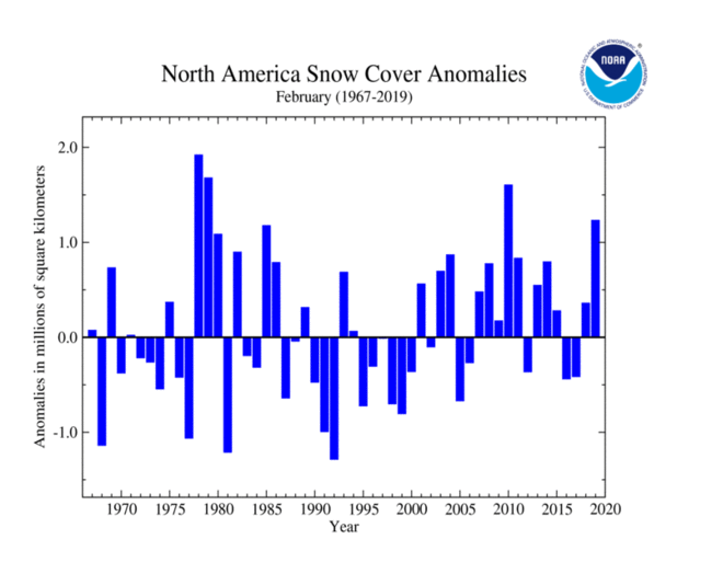
The February North American SCE was 18.35 million square km (7.08 million square miles), which is 1.23 million square km (470,000 square miles) above average. This was the largest North American SCE since 2010 and the fourth largest in the 53-year record. Only 1978, 1979, and 2010 had larger SCE for February. Snow cover was above average for much of the western, north-central, and northeastern contiguous United States. Below-average SCE was limited to parts the eastern contiguous U.S. Canada had its seventh largest SCE in its 53-year record and the contiguous U.S. had its fourth largest SCE on record. Alaska had near-average SCE, ranking as the 26th largest February SCE on record.

The Eurasian SCE during February was 27.68 million square km (10.69 million square miles), which is 800,000 square km (310,000 square miles) below average. This was the 12th smallest February SCE on record for Eurasia. Above-average SCE was mostly limited to western China, while below-average SCE was observed across much of Europe, southwestern Asia, as well as parts of northeastern China and eastern Mongolia.
Sea Ice Extent
| February 2019 | Sea Ice Extent | Anomaly 1991-2020 | Trend per decade | Rank (41 years) | Record | ||||
|---|---|---|---|---|---|---|---|---|---|
| million km² | million mi² | Year(s) | million km² | million mi² | |||||
| Northern Hemisphere | 14.39 | 5.56 | -3.16% | -3.03% | Largest | 35th | 1979 | 16.18 | 6.25 |
| Smallest | 7th | 2018 | 13.97 | 5.39 | |||||
| Southern Hemisphere | 2.65 | 1.02 | -14.24% | +0.97% | Largest | 35th | 2008 | 3.89 | 1.50 |
| Smallest | 6th | 2017 | 2.29 | 0.88 | |||||
| Ties: 2006 | |||||||||
| Globe | 17.04 | 6.58 | -5.07% | -2.34% | Largest | 36th | 1979 | 19.32 | 7.46 |
| Smallest | 6th | 2018 | 16.30 | 6.29 | |||||
Data Source: National Snow and Ice Data Center (NSIDC). Period of record: 1979–2019 (41 years)

According to the National Snow and Ice Data Center (NSIDC), the Northern Hemisphere (Arctic) sea ice extent — which is measured from passive microwave instruments onboard NOAA satellites — averaged for February 2019 was 14.40 million square km (5.56 million square miles), which is 900,000 square km (350,000 square miles), or 5.9 percent, below the 1981–2010 average. This value tied with 2015 as the seventh smallest February Arctic sea ice extent on record. The record low February sea ice extent occurred in 2018 at 13.95 million square km (5.39 million square miles). February 2019 marks the 17th consecutive February with below-average sea ice extent.
During February 2019, sea ice extent retreated in the Bering Sea, while sea ice growth occurred in the Barents Sea and the Sea of Okhotsk. The February 2019 sea ice extent in the Bering Sea was near-record low at 450,000 square km (170,000 square miles) or 44 percent below the 1981–2010 average. Only February 2018 had a lower sea ice extent for the region at 370,000 square km (140,000 square miles). Since 1979, February Arctic sea ice extent is decreasing at an average rate of 2.9 percent per decade.

The February Southern Hemisphere (Antarctic) sea ice extent was 2.66 million square km (1.03 million square miles), which was 410,000 square km (160,000 square miles), or 13.4 percent, below the 1981–2010 average. This extent was the fourth consecutive year with below-average February sea ice extent and the seventh smallest February Southern Hemisphere sea ice extent on record. The Antarctic sea ice reached its annual minimum extent on February 28 and again on March 1 at 954,000 square miles—the seventh lowest minimum extent in the satellite record.
For further information on the Northern and Southern Hemisphere snow and ice conditions, please visit the NSIDC News page.