NH Snow Cover Extent
| February 2018 | Snow Cover Extent | Anomaly 1991-2020 | Trend per decade | Rank (52 years) | Record | ||||||
|---|---|---|---|---|---|---|---|---|---|---|---|
| million km² | million mi² | million km² | million mi² | million km² | million mi² | Year(s) | million km² | million mi² | |||
| Northern Hemisphere | 46.29 | 17.87 | +0.51 | +0.20 | -0.08 | -0.03 | Largest | 23rd | 1978 | 51.32 | 19.81 |
| Smallest | 30th | 1990 | 42.16 | 16.28 | |||||||
| North America | 17.48 | 6.75 | +0.27 | +0.10 | +0.05 | +0.02 | Largest | 18th | 1978 | 19.04 | 7.35 |
| Smallest | 35th | 1991 | 15.63 | 6.03 | |||||||
| Eurasia | 28.82 | 11.13 | +0.26 | +0.10 | -0.13 | -0.05 | Largest | 28th | 1972 | 33.26 | 12.84 |
| Smallest | 25th | 2002 | 25.91 | 10.00 | |||||||
Data Source: Global Snow Laboratory, Rutgers University. Period of record: 1967–2018 (52 years)

The Northern Hemisphere snow cover extent (SCE) during February was 46.29 million square km (17.87 million square miles), 700,000 square km (270,000 square miles) above the 1981-2010 average. This was the 19th largest Northern Hemisphere SCE in the 52-year period of record and largest since 2014. The North American and Eurasian SCE were each above average. For the winter season (December 2018-February 2018), the Northern Hemisphere SCE was the 24th largest (29th smallest) on record at 220,000 square km (84,900 square miles) above average.
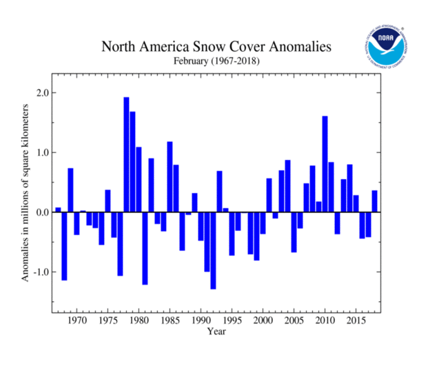
During February, the North American SCE was 360,000 square km (140,000 square miles) above the 1981-2010 average — the 19th largest on record and largest since 2014. An active storm pattern across southwestern Canada and the north-central U.S. resulted in above-average snow cover for the northwestern and north-central United States, the Canadian Rockies and the southern Canadian Prairies. Below-average snow cover was observed across parts of the southwestern U.S. and the Great Lakes region. The contiguous U.S. SCE was the 20th largest on record, the Canadian SCE was the 17th largest on record, while the Alaska SCE tied with four other years as the largest on record. The winter North American SCE was the 22nd largest on record at 130,000 square km (50,000 square miles) above average.

The Eurasian February SCE was 28.82 million square km (11.13 million square miles), 340,000 square km (130,000 square miles) above average. This ranked as the 24th largest February SCE for Eurasia. Above-average snow cover was observed across central and eastern Europe, southern Kazakhstan, and central to western China. Below-average snow cover was observed in western Europe, Turkey, Iran, and northeastern China. The winter Eurasian SCE was the 26th smallest (27th largest) on record at 90,000 million square km (35,000 square miles) above average.
Sea Ice Extent
| February 2018 | Sea Ice Extent | Anomaly 1991-2020 | Trend per decade | Rank (40 years) | Record | ||||
|---|---|---|---|---|---|---|---|---|---|
| million km² | million mi² | Year(s) | million km² | million mi² | |||||
| Northern Hemisphere | 13.97 | 5.39 | -5.99% | -3.10% | Largest | 40th | 1979 | 16.18 | 6.25 |
| Smallest | 1st | 2018 | 13.97 | 5.39 | |||||
| Southern Hemisphere | 2.33 | 0.90 | -24.60% | +1.62% | Largest | 39th | 2008 | 3.89 | 1.50 |
| Smallest | 2nd | 2017 | 2.29 | 0.88 | |||||
| Globe | 16.30 | 6.29 | -9.19% | -2.28% | Largest | 40th | 1979 | 19.32 | 7.46 |
| Smallest | 1st | 2018 | 16.30 | 6.29 | |||||
Data Source: National Snow and Ice Data Center (NSIDC). Period of record: 1979–2018 (40 years)

According to the National Snow and Ice Data Center (NSIDC), the Northern Hemisphere (Arctic) sea ice extent — which is measured from passive microwave instruments onboard NOAA satellites —averaged for February 2018 was 13.95 million square km (5.39 million square miles), 1.35 million square km (521,000 square miles), or 8.82 percent, below the 1981-2010 average. This was the smallest February Arctic sea ice extent on record, dipping below the previous record of 14.11 million square km (5.45 million square miles) set just last year in 2018. Sea ice expanded slowly in early February with ice growth nearly stopping for a few days mid-month, with expansion continuing later in the month. Some regions of the Arctic, particularly in the Bering Sea, experienced periods of shrinking sea ice during the time of year when expansion is typically observed. In general, both the Bering and Barents Seas observed below-average ice coverage during the month with near-average ice coverage elsewhere. The ice edge was much further north than normal in parts of the Barents Sea. An unusual intrusion of warm air infiltrated parts of the Arctic during February, with temperatures near the North Pole going above the freezing mark. This is the third year that such an occurrence has been observed, with such instances occurring less frequently in the past. The warm temperatures contributed to the below-average ice coverage. The annual sea ice maximum extent is expected to occur in March at near-record low levels. Overall, February Arctic ice extent is decreasing at an average rate of 3.0 percent per decade.

The February Southern Hemisphere sea ice extent was 2.29 million square km (884,000 square miles), which was 780,000 million square km 310,000 square miles), or 25.41 percent, below the 1981-2010 average. This was the second smallest February Southern Hemisphere sea ice extent on record. The smallest occurred just last year in 2018 at 2.27 million square km (876,000 square miles). Sea ice extent was particularly low in the Ross and western Amundsen Sea region, and along the southern reaches of the Bellingshausen Sea. Southern Hemisphere sea ice extent is increasing at an average rate of 1.63 percent per decade, with substantial inter-annual variability. On February 20th and 21st, the Antarctic sea ice reached its annual minimum extent at 2.18 million square kilometers (842,000 square miles), the second lowest minimum extent in the satellite record. The record lowest extent occurred on March 3, 2018 and was 70,000 square kilometers (27,000 square miles) smaller.
For further information on the Northern and Southern Hemisphere snow and ice conditions, please visit the NSIDC News page.